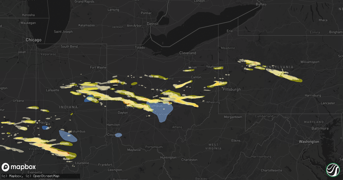
Hail Map in Ohio on March 22, 2026
Get this storm
March 22 map
$229
one time, instant access
Download today. No call, no setup
Keep the $229
Bought the map and want the full workflow? Apply the entire $229 to a subscription within 7 days. None of it is wasted.
Every map, not just this one
This buys you this map. Subscription and you get every map we run, in the markets you choose from a few cities to whole states to nationwide. Plus real-time alerts the moment a storm fires.
Contact data
Name, contact info, occupancy, even credit band for addresses in the footprint. You go from where it hit to who to call.
Become the source they trust
Unlimited branding weather history reports on demand. You already have the documented answer ready for the property owner, and you are the one who showed up with it.
Property data and RoofTrace estimates
Pull up any address you have got, its value and the exact code rules for that jurisdiction, straight from One Click Code. Then RoofTrace estimates the squares, pitch, and roof value, priced the way you price.
Storm reports in Ohio
Ohio
| Date | Description |
|---|---|
| 03/22/20266:59 PM CDT | A local report indicates 1.00 inch wind near 4 S Arlington |
| 03/22/20266:52 PM CDT | Time est from radar. |
| 03/22/20265:55 PM CDT | A local report indicates 1.00 inch wind near Quaker City |
| 03/22/20265:50 PM CDT | Public reported with picture via social media. |
| 03/22/20265:45 PM CDT | Public reported with picture via social media. |
| 03/22/20265:42 PM CDT | A local report indicates 1.00 inch wind near Old Washington |
| 03/22/20265:35 PM CDT | Public reported with picture via social media. Time estimated based off radar. |
| 03/22/20265:25 PM CDT | A local report indicates 1.00 inch wind near New Concord |
| 03/22/20265:25 PM CDT | Report from mping: quarter |
| 03/22/20265:02 PM CDT | A local report indicates 1.50 inch wind near 3 SSE Dresden |
| 03/22/20264:57 PM CDT | A local report indicates 1.00 inch wind near Dresden |
| 03/22/20264:27 PM CDT | A local report indicates 1.00 inch wind near Saint Louisville |
| 03/22/20264:17 PM CDT | A local report indicates 1.00 inch wind near Johnstown |
| 03/21/202610:25 PM CDT | Asos station kluk cincinnati lunken field. |
| 03/21/202610:05 PM CDT | Tree down along town highway 423. |
| 03/21/202610:03 PM CDT | Corrects previous tstm wnd dmg report from 3 w old washington. Several trees uprooted in backyard. |
| 03/21/202610:00 PM CDT | Tree down along bell bottom rd and state route 668. |
| 03/21/202610:00 PM CDT | Tree down by junction city oh along garey rd ne. |
| 03/21/20269:47 PM CDT | A local report indicates 1.75 inch wind near Heath |
| 03/21/20269:47 PM CDT | Lasted two minutes. |
| 03/21/20269:47 PM CDT | Hail lasted about 2-3 minutes. |
| 03/21/20269:47 PM CDT | Hail lasted about 2-3 minutes. |
| 03/21/20269:45 PM CDT | Several trees uprooted in backyard. |
| 03/21/20269:45 PM CDT | A local report indicates 1.50 inch wind near West Jefferson |
| 03/21/20269:45 PM CDT | A local report indicates 1.00 inch wind near Plain City |
| 03/21/20269:42 PM CDT | A local report indicates 1.25 inch wind near 15 W Westerville |
| 03/21/20269:40 PM CDT | A local report indicates 1.00 inch wind near London |
| 03/21/20269:30 PM CDT | Social media report of half dollar sized hail. Time estimated from radar. |
| 03/21/20269:30 PM CDT | Report from mping: quarter |
| 03/21/20269:25 PM CDT | Tree down on wires in the 14000 block of palmer road. |
| 03/21/20269:20 PM CDT | A local report indicates 1.50 inch wind near North Hampton |
| 03/21/20269:19 PM CDT | Asos station kcmh columbus john glenn international airport. |
| 03/21/20269:15 PM CDT | Awos station ktzr columbus bolton field. |
| 03/21/20269:12 PM CDT | A local report indicates 1.00 inch wind near 1 W Dublin |
| 03/21/20269:08 PM CDT | A local report indicates 1.00 inch wind near Plain City |
| 03/21/20269:02 PM CDT | Report from mping: half dollar |
| 03/21/20269:00 PM CDT | A local report indicates 1.50 inch wind near 2 E Unionville Center |
| 03/21/20268:50 PM CDT | Social media report of half dollar sized hail just south of the tusc county line. Time estimated from radar and report. |
| 03/21/20268:40 PM CDT | A local report indicates 1.00 inch wind near Bradford |
| 03/21/20268:40 PM CDT | A local report indicates 1.00 inch wind near Mount Vernon |
| 03/21/20268:34 PM CDT | A local report indicates 1.00 inch wind near West Liberty |
| 03/21/20268:25 PM CDT | A local report indicates 1.00 inch wind near 3 NW Greenville |
| 03/21/20268:20 PM CDT | Time est from radar. |
| 03/21/20268:16 PM CDT | A local report indicates 1.00 inch wind near Wilmot |
| 03/21/20268:14 PM CDT | Quarter to half dollar sized hail in glenmont. |
| 03/21/20268:10 PM CDT | A local report indicates 1.00 inch wind near 5 E Millersburg |
| 03/21/20268:08 PM CDT | Time est from radar. |
| 03/21/20268:01 PM CDT | A local report indicates 1.00 inch wind near Millersburg |
| 03/21/20268:00 PM CDT | Picture from social media. |
| 03/21/20267:54 PM CDT | A local report indicates 1.00 inch wind near 2 W Chickasaw |
| 03/21/20267:51 PM CDT | A local report indicates 1.00 inch wind near Campbell |
| 03/21/20267:50 PM CDT | A local report indicates 1.00 inch wind near Poland |
| 03/21/20267:49 PM CDT | A local report indicates 1.00 inch wind near 1 SW Mansfield |
| 03/21/20267:47 PM CDT | A local report indicates 1.00 inch wind near 2 S Mansfield |
| 03/21/20267:46 PM CDT | Report from mping: quarter |
| 03/21/20267:46 PM CDT | A local report indicates 1.00 inch wind near 1 N Lexington |
| 03/21/20267:46 PM CDT | A local report indicates 1.00 inch wind near 1 NW Poland |
| 03/21/20267:46 PM CDT | Pea sized up to quarter sized hail in mansfield. |
| 03/21/20267:45 PM CDT | A local report indicates 1.00 inch wind near Barberton |
| 03/21/20267:44 PM CDT | A local report indicates 1.00 inch wind near 1 NW Barberton |
| 03/21/20267:44 PM CDT | A local report indicates 1.00 inch wind near Mount Vernon |
| 03/21/20267:42 PM CDT | A local report indicates 1.00 inch wind near 5 E Sparta |
| 03/21/20267:40 PM CDT | A local report indicates 1.00 inch wind near 3 NNW Lexington |
| 03/21/20267:35 PM CDT | Time est from radar. |
| 03/21/20267:35 PM CDT | A local report indicates 1.00 inch wind near 2 N Galion |
| 03/21/20267:35 PM CDT | A local report indicates 1.00 inch wind near Rittman |
| 03/21/20267:30 PM CDT | A local report indicates 1.00 inch wind near 2 SW Westerville |
| 03/21/20267:29 PM CDT | A local report indicates 1.00 inch wind near 1 SSE Bucyrus |
| 03/21/20267:20 PM CDT | A local report indicates 1.40 inch wind near Westerville |
| 03/21/20267:20 PM CDT | A local report indicates 1.00 inch wind near 1 SSW Worthington |
| 03/21/20267:19 PM CDT | Time est from radar. |
| 03/21/20267:10 PM CDT | Time est from radar. |
| 03/21/20267:10 PM CDT | Time est from radar. |
| 03/21/20267:10 PM CDT | Time est from radar. |
| 03/21/20267:09 PM CDT | Time est from radar. |
All States Impacted by Hail Map on March 22, 2026
Cities Impacted by Hail Map on March 22, 2026
- Spring Mills, PA
- Clarion, PA
- Shippenville, PA
- Sligo, PA
- Summerville, PA
- Strattanville, PA
- Corsica, PA
- Brookville, PA
- Johnstown, OH
- Grampian, PA
- Sunbury, OH
- Newark, OH
- Utica, OH
- Granville, OH
- West Decatur, PA
- Morrisdale, PA
- Wallaceton, PA
- Bigler, PA
- Woodland, PA
- Allport, PA
- Hawk Run, PA
- Munson, PA
- Philipsburg, PA
- Saint Louisville, OH
- Winburne, PA
- Lanse, PA
- Alexandria, OH
- Mineral Springs, PA
- Clearfield, PA
- Hopedale, OH
- Scio, OH
- Jewett, OH
- Bellefonte, PA
- Port Matilda, PA
- State College, PA
- Julian, PA
- University Park, PA
- Reynoldsville, PA
- Knox, PA
- Parker, PA
- Emlenton, PA
- Nashport, OH
- Dresden, OH
- Frazeysburg, OH
- Du Bois, PA
- Rockton, PA
- Trinway, OH
- New Bethlehem, PA
- Fairmount City, PA
- Mayport, PA
- Zanesville, OH
- Adamsville, OH
- Coshocton, OH
- Cambridge, OH
- New Concord, OH
- Norwich, OH
- Kennerdell, PA
- Luthersburg, PA
- Marble, PA
- Venus, PA
- Cranberry, PA
- Sykesville, PA
- Irondale, OH
- Bergholz, OH
- New Cumberland, WV
- Wellsville, OH
- Hammondsville, OH
- Newell, WV
- Salineville, OH
- Toronto, OH
- Chester, WV
- Hookstown, PA
- Georgetown, PA
- Sigel, PA
- Clarington, PA
- Lucinda, PA
- Kossuth, PA
- Industry, PA
- Osceola Mills, PA
- Kipling, OH
- Byesville, OH
- Lore City, OH
- Senecaville, OH
- Aliquippa, PA
- Shippingport, PA
- Monaca, PA
- Brockway, PA
- Conway, PA
- Baden, PA
- Sewickley, PA
- Freedom, PA
- Ambridge, PA
- East Liverpool, OH
- Carrollton, OH
- Salesville, OH
- Quaker City, OH
- Bloomingdale, OH
- Troutville, PA
- Punxsutawney, PA
- Knox Dale, PA
- Falls Creek, PA
- Hyde, PA
- Curwensville, PA
- Galveston, IN
- Flora, IN
- Kokomo, IN
- Walton, IN
- Bunker Hill, IN
- Miami, IN
- Rimersburg, PA
- Callensburg, PA
- Olanta, PA
- Glen Richey, PA
- Houtzdale, PA
- Harmony, PA
- Midland, PA
- Ellwood City, PA
- Fombell, PA
- Marion, IN
- Richmond, OH
- Stratton, OH
- Weirton, WV
- Amsterdam, OH
- Converse, IN
- Clinton, PA
- Imperial, PA
- Swayzee, IN
- Sweetser, IN
- Van Buren, IN
- Celina, OH
- Rockford, OH
- Mendon, OH
- Spencerville, OH
- Venedocia, OH
- Saint Marys, OH
- Wapakoneta, OH
- Montpelier, IN
- Warren, IN
- Hartford City, IN
- Jonesboro, IN
- Gas City, IN
- Fairmount, IN
- Hawthorn, PA
- Amboy, IN
- Greentown, IN
- Moshannon, PA
- Camden, IN
- Prospect, PA
- Delphi, IN
- Bringhurst, IN
- Frenchville, PA
- Centre Hall, PA
- Huntingdon, PA
- Boalsburg, PA
- Lemont, PA
- Columbus, OH
- Dublin, OH
- Powell, OH
- Keystone, IN
- Poneto, IN
- Fowlerton, IN
- Upland, IN
- Reedsville, PA
- Milroy, PA
- Lima, OH
- Beaverdam, OH
- Columbus Grove, OH
- Bluffton, OH
- Delphos, OH
- Van Wert, OH
- Buckland, OH
- Shelbyville, IL
- Bluffton, IN
- Forest, OH
- Galena, OH
- Lewis Center, OH
- Portersville, PA
- Dunkirk, OH
- Upper Sandusky, OH
- Ada, OH
- Findlay, IL
- Westerville, OH
- Pennville, IN
- Portland, IN
- Dunkirk, IN
- Indianola, IL
- Sidell, IL
- Georgetown, IL
- Ridge Farm, IL
- Chrisman, IL
- Windsor, IL
- Mattoon, IL
- Bethany, IL
- Windfall, IN
- Elwood, IN
- Nevada, OH
- Bucyrus, OH
- Gays, IL
- Bryant, IN
- Burlington, IN
- Cutler, IN
- Russiaville, IN
- Metcalf, IL
- Centerburg, OH
- Berne, IN
- Geneva, IN
- Charleston, IL
- Westfield, IL
- Ashmore, IL
- Uniopolis, OH
- Summitville, IN
- Gaston, IN
- Coburn, PA
- Beaver Springs, PA
- Lewistown, PA
- Richfield, PA
- Mifflintown, PA
- McClure, PA
- McAlisterville, PA
- Greenville, IL
- Keyesport, IL
- Vandalia, IL
- Kansas, IL
- Martinsville, IL
- Marshall, IL
- Paris, IL
- Dennison, IL
- Muncie, IN
- Matthews, IN
- Eaton, IN
- Albany, IN
- Barberton, OH
- Doylestown, OH
- Rittman, OH
- Wadsworth, OH
- Sterling, OH
- Fort Recovery, OH
- Coldwater, OH
- Crestline, OH
- Galion, OH
- Terre Haute, IN
- Pataskala, OH
- Lerna, IL
- Greenup, IL
- Toledo, IL
- Trilla, IL
- Akron, OH
- Willshire, OH
- New Albany, OH
- Altamont, IL
- Beecher City, IL
- Cayuga, IN
- Dana, IN
- Lakewood, IL
- Clinton, OH
- Tiro, OH
- Sycamore, OH
- Mansfield, OH
- Shelby, OH
- Mount Vernon, OH
- Howard, OH
- Gambier, OH
- Effingham, IL
- Wheeler, IL
- Newton, IL
- Patoka, IL
- Vernon, IL
- Redkey, IN
- Ridgeville, IN
- Farmland, IN
- Parker City, IN
- Casey, IL
- Yorkshire, OH
- Maria Stein, OH
- Minster, OH
- Fort Loramie, OH
- Brinkhaven, OH
- Glenmont, OH
- Killbuck, OH
- La Rue, OH
- Mount Victory, OH
- Tipton, IN
- Sharpsville, IN
- Lowellville, OH
- Edinburg, PA
- Pulaski, PA
- Bloomingdale, IN
- Rockville, IN
- Marshall, IN
- Brazil, IN
- Carbon, IN
- Montezuma, IN
- Saint Henry, OH
- Alma, IL
- Hillsdale, IN
- Willow Hill, IL
- Saratoga, IN
- Winchester, IN
- Selma, IN
- Union City, IN
- Sidney, OH
- Anna, OH
- Pemberton, OH
- Port Jefferson, OH
- Quincy, OH
- Maplewood, OH
- Jackson Center, OH
- Millersburg, OH
- Wilmot, OH
- Fredericksburg, OH
- Dundee, OH
- Navarre, OH
- Beach City, OH
- Big Prairie, OH
- Danville, OH
- Lakeville, OH
- Greencastle, IN
- Fillmore, IN
- Oblong, IL
- Sumner, IL
- Loudonville, OH
- Youngstown, OH
- Struthers, OH
- Kinmundy, IL
- Cloverdale, IN
- Reelsville, IN
- West Terre Haute, IN
- Centerpoint, IN
- Mason, IL
- Warsaw, OH
- Strasburg, OH
- Bolivar, OH
- Holmesville, OH
- Conesville, OH
- West Liberty, OH
- Urbana, OH
- Bellefontaine, OH
- De Graff, OH
- Greenville, OH
- Ansonia, OH
- Union City, OH
- Flat Rock, IL
- Robinson, IL
- Palestine, IL
- Bradford, OH
- Marengo, OH
- Ashley, OH
- Cardington, OH
- West Lafayette, OH
- Jewett, IL
- Sugarcreek, OH
- Waldo, OH
- Delaware, OH
- Flora, IL
- Xenia, IL
- Louisville, IL
- Kenton, OH
- Alexandria, IN
- Saint Elmo, IL
- Teutopolis, IL
- Dieterich, IL
- West Liberty, IL
- Dundas, IL
- Iuka, IL
- Bowling Green, IN
- Freedom, IN
- Coal City, IN
- Clay City, IN
- Watson, IL
- Stilesville, IN
- Coatesville, IN
- Montrose, IL
- Cory, IN
- Pimento, IN
- Lewis, IN
- Carlisle, IN
- Merom, IN
- Oaktown, IN
- Lawrenceville, IL
- Bruceville, IN
- Edwardsport, IN
- Sandborn, IN
- Westphalia, IN
- Freelandville, IN
- Lyons, IN
- Bicknell, IN
- Ragsdale, IN
- New Philadelphia, OH
- Anderson, IN
- Yorktown, IN
- Daleville, IN
- North Lewisburg, OH
- Cable, OH
- Mingo, OH
- Plainfield, OH
- Kimbolton, OH
- Newcomerstown, OH
- Versailles, OH
- Sparta, OH
- Fredericktown, OH
- Covington, OH
- Harrod, OH
- Waynesfield, OH
- Noble, IL
- Clay City, IL
- Belle Center, OH
- Sullivan, IN
- Kempton, IN
- Patricksburg, IN
- Freeport, OH
- Port Washington, OH
- Tippecanoe, OH
- Modoc, IN
- Losantville, IN
- Walhonding, OH
- Martinsburg, OH
- Beaver Falls, PA
- Rosewood, OH
- Conover, OH
- Saint Paris, OH
- Parkersburg, IL
- Olney, IL
- Calhoun, IL
- Mount Erie, IL
- Washington, IN
- Russia, OH
- Houston, OH
- Piqua, OH
- Bridgeport, IL
- Vincennes, IN
- Troy, OH
- Fletcher, OH
- Milford Center, OH
- Marysville, OH
- Mechanicsburg, OH
- Woodstock, OH
- Irwin, OH
- Plain City, OH
- Plainville, IN
- Ellettsville, IN
- Bloomington, IN
- Casstown, OH
- Elnora, IN
- Zanesfield, OH
- Hilliard, OH
- Amlin, OH
- Odon, IN
- Newberry, IN
- Wheatland, IN
- Montgomery, IN
- Crane, IN
- Loogootee, IN
- Cannelburg, IN
- Shoals, IN
- Gettysburg, OH
- North Hampton, OH
- New Carlisle, OH
- Christiansburg, OH
- Tremont City, OH
- Springfield, OH
- Rogers, OH
- Lisbon, OH
- Darlington, PA
- Fountain City, IN
- Richmond, IN
- Bargersville, IN
- Owensburg, IN
- Bloomfield, IN
- Scotland, IN
- Unionville, IN
- Shreve, OH
- Nashville, IN
- Flushing, OH
- Martinsville, IN
- Cadiz, OH
- Richwood, OH
- Prospect, OH
- Fresno, OH
- Williams, IN
- Bedford, IN
- Monrovia, IN
- South Vienna, OH
- Piedmont, OH
- London, OH
- Catawba, OH
- South Charleston, OH
- West Jefferson, OH
- Galloway, OH
- Blacklick, OH
- Orient, OH
- Grove City, OH
- Commercial Point, OH
- Ashville, OH
- Lockbourne, OH
- Groveport, OH
- Reynoldsburg, OH
- Carroll, OH
- Kirkersville, OH
- Pickerington, OH
- Amanda, OH
- Lancaster, OH
- Buckeye Lake, OH
- Millersport, OH
- Hebron, OH
- Etna, OH
- Canal Winchester, OH
- Stoutsville, OH
- Baltimore, OH
- Heath, OH
- Lithopolis, OH
- Heltonville, IN
- Norman, IN
- Columbus, IN
- Brownstown, IN
- Medora, IN
- Freetown, IN
- Seymour, IN
- West Baden Springs, IN
- French Lick, IN
- Dubois, IN
- Mitchell, IN
- Jasper, IN
- Paoli, IN
- Orleans, IN
- Hardinsburg, IN
- Oolitic, IN
- Vallonia, IN
- Mount Sterling, OH
- Harrisburg, OH
- Glenford, OH
- Pleasantville, OH
- Bremen, OH
- Somerset, OH
- Rushville, OH
- Mount Perry, OH
- Laurelville, OH
- Jacksontown, OH
- Thornville, OH
- Tarlton, OH
- Sugar Grove, OH
- Thurston, OH
- Kingston, OH
- Circleville, OH
- Rockbridge, OH
- Fredericksburg, IN
- Salem, IN
- Campbellsburg, IN
- Creston, OH
- Seville, OH
- Oakland, IL
- Marengo, IN
- Williamsport, OH
- Milltown, IN
- Pennsylvania Furnace, PA
- Palmyra, IN
- Depauw, IN
- Pekin, IN
- Greenville, IN
- Borden, IN
- Ramsey, IN
- English, IN
- Corydon, IN
- New Middletown, IN
- Elizabeth, IN
- Stump Creek, PA
- New Salisbury, IN
- New Castle, PA
- Campbell, OH
- New Wilmington, PA
- Uniontown, OH
- Bowerston, OH
- Silver Grove, KY
- Cincinnati, OH
- Dayton, KY
- Fort Thomas, KY
- Newport, KY
- Melbourne, KY
- Amelia, OH
- Milford, OH
- Batavia, OH
- Bellevue, KY
- Middletown, IN
- Mooreland, IN
- Lynn, IN
- Williamsburg, IN
- Mooresville, IN
- Plainfield, IN
- Clayton, IN
- Indianapolis, IN
- Greenwood, IN
- Beech Grove, IN
- Avon, IN
- Franklin, IN
- Ringgold, PA
- Morgantown, IN
- Nineveh, IN
- Trafalgar, IN
- Leetsdale, PA
- Crescent, PA
- South Heights, PA
- La Fontaine, IN
- Wabash, IN
- Urbana, IN


