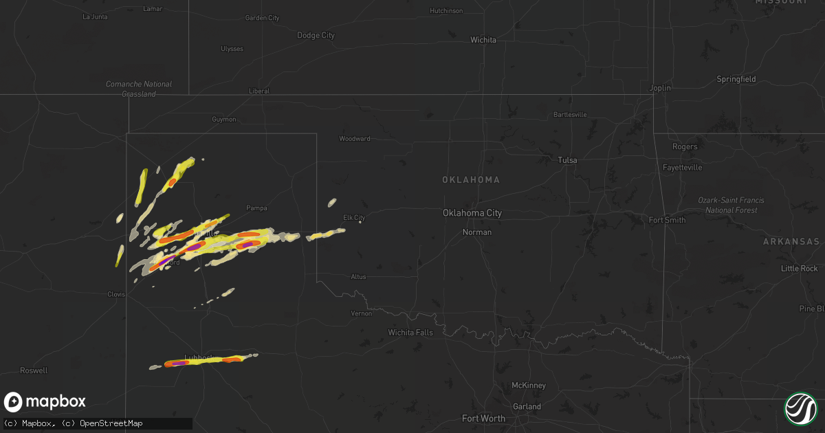
Hail Map in Oklahoma on March 22, 2019
Get this storm
March 22 map
$229
one time, instant access
Download today. No call, no setup
Keep the $229
Bought the map and want the full workflow? Apply the entire $229 to a subscription within 7 days. None of it is wasted.
Every map, not just this one
This buys you this map. Subscription and you get every map we run, in the markets you choose from a few cities to whole states to nationwide. Plus real-time alerts the moment a storm fires.
Contact data
Name, contact info, occupancy, even credit band for addresses in the footprint. You go from where it hit to who to call.
Become the source they trust
Unlimited branding weather history reports on demand. You already have the documented answer ready for the property owner, and you are the one who showed up with it.
Property data and RoofTrace estimates
Pull up any address you have got, its value and the exact code rules for that jurisdiction, straight from One Click Code. Then RoofTrace estimates the squares, pitch, and roof value, priced the way you price.
Storm reports in Oklahoma
Oklahoma
| Date | Description |
|---|---|
| 03/22/20194:23 PM CDT | Thunderstorm winds caused damage to brick building. |
| 03/22/201911:55 AM CDT | A local report indicates 59 MPH wind near 4 ESE ERICK |
| 03/22/20196:59 AM CDT | At 1158 PM CDT, a severe thunderstorm was located near Delhi, moving east at 30 mph. HAZARD...60 mph wind gusts and quarter size hail. SOURCE...Radar indicated. IMPACT...Hail damage to vehicles is expected. Expect wind damage to roofs, siding, and trees. Locations impacted include... Elk City, Sayre, Carter, Retrop and Delhi. |
| 03/22/20196:20 AM CDT | At 1120 PM CDT, a severe thunderstorm was located 8 miles southeast of Shamrock, moving east at 30 mph. HAZARD...60 mph wind gusts and quarter size hail. SOURCE...Radar indicated. IMPACT...Hail damage to vehicles is expected. Expect wind damage to roofs, siding, and trees. Locations impacted include... Erick and Texola. |
| 03/22/20195:50 AM CDT | At 1050 PM CDT, a severe thunderstorm was located 6 miles northeast of Leedey, moving northeast at 30 mph. HAZARD...60 mph wind gusts and penny size hail. SOURCE...The Camargo Mesonet had a 62 mph wind gust. IMPACT...Expect damage to roofs, siding, and trees. Locations impacted include... Leedey, Camargo, Putnam and Cestos. |
| 03/22/20195:30 AM CDT | At 1029 PM CDT, severe thunderstorms were located along a line extending from 5 miles southeast of Lefors to 9 miles southeast of Alanreed, moving east at 30 mph. HAZARD...Golf ball size hail and 60 mph wind gusts. SOURCE...Radar indicated. IMPACT...Minor damage to roofs, siding, and trees is possible. People and animals outdoors will be injured. Expect hail damage to roofs, siding, windows, and vehicles. Locations impacted include... Shamrock, Briscoe, Wheeler, Mclean, Lefors, New Mobeetie, Twitty, Allison, Lela, Kellerville, Dozier, Alanreed and Mobeetie. |
| 03/22/20192:00 AM CDT | A local report indicates 62 MPH wind near OKARCHE |
| 03/22/20191:05 AM CDT | Oklahoma mesonet station. Winds from the north-northwest. |
| 03/22/201912:59 AM CDT | At 559 PM CDT, severe thunderstorms were located along a line extending from near Texhoma to 7 miles north of Sunray to Channing, moving northeast at 35 mph. HAZARD...60 mph wind gusts and half dollar size hail. SOURCE...Radar indicated. IMPACT...Minor damage to roofs, siding, and trees is possible. Hail damage to vehicles is expected. Locations impacted include... Dumas, Cactus, Sunray, Gruver, Channing, Morse, Four Way, Masterson and Texhoma. |
| 03/22/201912:39 AM CDT | A local report indicates 58 MPH wind near 2 SW BURNS FLAT |
| 03/22/201912:15 AM CDT | North winds gusting to 60 mph reported along sh-152 north of carter. |
| 03/21/201910:40 PM CDT | A local report indicates 62 MPH wind near 4 WNW CAMARGO |
All States Impacted by Hail Map on March 22, 2019
Cities Impacted by Hail Map on March 22, 2019
- Dalhart, TX
- Channing, TX
- Claude, TX
- Clarendon, TX
- Crosbyton, TX
- Lubbock, TX
- Ropesville, TX
- Ransom Canyon, TX
- Wolfforth, TX
- Lorenzo, TX
- Ralls, TX
- Levelland, TX
- Slaton, TX
- Hereford, TX
- Friona, TX
- Amarillo, TX
- Vega, TX
- Canyon, TX
- Wellington, TX
- Texola, OK
- Erick, OK
- Summerfield, TX
- Happy, TX
- Wayside, TX
- Wildorado, TX
- Panhandle, TX
- Kress, TX
- Silverton, TX
- Stratford, TX
- Dumas, TX
- Hartley, TX
- Sayre, OK
- Plainview, TX
- Pampa, TX
- Groom, TX
- Dickens, TX
- Logan, NM
- Adrian, TX
- Broadview, NM
- Bard, NM
- Carter, OK
- Cheyenne, OK
- Sunray, TX
- Mclean, TX
- Shamrock, TX
- Santa Fe, NM
- San Jon, NM
- Bovina, TX
- Farwell, TX
- Canute, OK
- Sundown, TX
- Glorieta, NM


