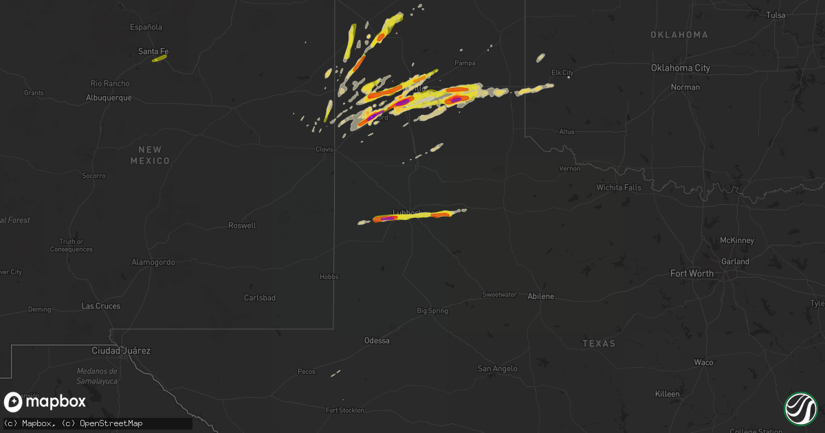
Hail Map on March 22, 2019
Get this storm
March 22 map
$229
one time, instant access
Download today. No call, no setup
Keep the $229
Bought the map and want the full workflow? Apply the entire $229 to a subscription within 7 days. None of it is wasted.
Every map, not just this one
This buys you this map. Subscription and you get every map we run, in the markets you choose from a few cities to whole states to nationwide. Plus real-time alerts the moment a storm fires.
Contact data
Name, contact info, occupancy, even credit band for addresses in the footprint. You go from where it hit to who to call.
Become the source they trust
Unlimited branding weather history reports on demand. You already have the documented answer ready for the property owner, and you are the one who showed up with it.
Property data and RoofTrace estimates
Pull up any address you have got, its value and the exact code rules for that jurisdiction, straight from One Click Code. Then RoofTrace estimates the squares, pitch, and roof value, priced the way you price.
States Impacted by Hail Map on March 22, 2019
Storm reports
Virginia
| Date | Description |
|---|---|
| 03/22/20196:00 PM CDT | Mesonet station va049... 1 n yorktown. |
| 03/22/20194:34 PM CDT | Numerous trees and wires down. |
| 03/22/20194:25 PM CDT | Tree down near the intersection of va-620 alden road and allwine avenue. |
| 03/22/20194:15 PM CDT | Multiple trees and wires down. |
| 03/22/20194:14 PM CDT | Numerous trees and wires down. |
| 03/22/20194:12 PM CDT | Power lines down near the intersection of va-605 bloomsbury road and brandy lane. |
| 03/22/20194:07 PM CDT | Numerous trees and wires down throughout the city. |
| 03/22/20193:04 PM CDT | Tree down on wires in the 4200 block of shenandoah avenue. |
| 03/22/20192:52 PM CDT | Tree down blocking va-676 towlston road near shouse drive. |
| 03/22/20192:51 PM CDT | Tree down in the 15400 block of va-658 compton road. |
| 03/22/20192:46 PM CDT | Two trees down in the 1000 block of va-674 springvale road. |
| 03/22/20192:36 PM CDT | Downed tree near riverside parkway and deerfield avenue. |
| 03/22/20192:35 PM CDT | A local report indicates 59 MPH wind near LEESBURG EXEC ARPT |
| 03/22/20192:30 PM CDT | Downed tree near riverside parkway and deefield ave |
Oklahoma
| Date | Description |
|---|---|
| 03/22/20194:23 PM CDT | Thunderstorm winds caused damage to brick building. |
| 03/22/201911:55 AM CDT | A local report indicates 59 MPH wind near 4 ESE ERICK |
| 03/22/20196:59 AM CDT | At 1158 PM CDT, a severe thunderstorm was located near Delhi, moving east at 30 mph. HAZARD...60 mph wind gusts and quarter size hail. SOURCE...Radar indicated. IMPACT...Hail damage to vehicles is expected. Expect wind damage to roofs, siding, and trees. Locations impacted include... Elk City, Sayre, Carter, Retrop and Delhi. |
| 03/22/20196:20 AM CDT | At 1120 PM CDT, a severe thunderstorm was located 8 miles southeast of Shamrock, moving east at 30 mph. HAZARD...60 mph wind gusts and quarter size hail. SOURCE...Radar indicated. IMPACT...Hail damage to vehicles is expected. Expect wind damage to roofs, siding, and trees. Locations impacted include... Erick and Texola. |
| 03/22/20195:50 AM CDT | At 1050 PM CDT, a severe thunderstorm was located 6 miles northeast of Leedey, moving northeast at 30 mph. HAZARD...60 mph wind gusts and penny size hail. SOURCE...The Camargo Mesonet had a 62 mph wind gust. IMPACT...Expect damage to roofs, siding, and trees. Locations impacted include... Leedey, Camargo, Putnam and Cestos. |
| 03/22/20195:30 AM CDT | At 1029 PM CDT, severe thunderstorms were located along a line extending from 5 miles southeast of Lefors to 9 miles southeast of Alanreed, moving east at 30 mph. HAZARD...Golf ball size hail and 60 mph wind gusts. SOURCE...Radar indicated. IMPACT...Minor damage to roofs, siding, and trees is possible. People and animals outdoors will be injured. Expect hail damage to roofs, siding, windows, and vehicles. Locations impacted include... Shamrock, Briscoe, Wheeler, Mclean, Lefors, New Mobeetie, Twitty, Allison, Lela, Kellerville, Dozier, Alanreed and Mobeetie. |
| 03/22/20192:00 AM CDT | A local report indicates 62 MPH wind near OKARCHE |
| 03/22/20191:05 AM CDT | Oklahoma mesonet station. Winds from the north-northwest. |
| 03/22/201912:59 AM CDT | At 559 PM CDT, severe thunderstorms were located along a line extending from near Texhoma to 7 miles north of Sunray to Channing, moving northeast at 35 mph. HAZARD...60 mph wind gusts and half dollar size hail. SOURCE...Radar indicated. IMPACT...Minor damage to roofs, siding, and trees is possible. Hail damage to vehicles is expected. Locations impacted include... Dumas, Cactus, Sunray, Gruver, Channing, Morse, Four Way, Masterson and Texhoma. |
| 03/22/201912:39 AM CDT | A local report indicates 58 MPH wind near 2 SW BURNS FLAT |
| 03/22/201912:15 AM CDT | North winds gusting to 60 mph reported along sh-152 north of carter. |
| 03/21/201910:40 PM CDT | A local report indicates 62 MPH wind near 4 WNW CAMARGO |
New Mexico
| Date | Description |
|---|---|
| 03/22/20193:24 PM CDT | A local report indicates 1.00 inch wind near 1 S BROADVIEW |
| 03/22/20192:25 PM CDT | A local report indicates 1.00 inch wind near 2 E GLORIETA |
| 03/22/20192:10 PM CDT | A local report indicates 1.25 inch wind near 13 SSE SANTA FE |
| 03/22/20192:08 PM CDT | A local report indicates 1.00 inch wind near 1 N ESPANOLA |
District of Columbia
| Date | Description |
|---|---|
| 03/22/20193:10 PM CDT | A local report indicates 59 MPH wind near REAGAN NATIONAL ARPT |
| 03/22/20193:02 PM CDT | Tree down on waterside drive northwest between rock creek and potomac parkway northwest and massachusetts avenue northwest. |
| 03/21/201910:52 PM CDT | At 351 PM EDT, a severe thunderstorm was located near Oakton, or near Reston, moving southeast at 50 mph. HAZARD...60 mph wind gusts. Wind gusts over 50 mph were reported in Winchester, Leesburg and at Dulles Airport. SOURCE...Radar indicated. IMPACT...Damaging winds will cause some trees and large branches to fall. This could injure those outdoors, as well as damage homes and vehicles. Roadways may become blocked by downed trees. Localized power outages are possible. Unsecured light objects may become projectiles. Locations impacted include... Arlington, Alexandria, Waldorf, Dale City, Bethesda, Bowie, Annandale, Clinton, Springfield, College Park, Fort Washington, Greenbelt, Langley Park, Beltsville, Fort Hunt, Groveton, Forestville, Falls Church, Huntington and Largo. |
| 03/21/201910:26 PM CDT | At 326 PM EDT, severe thunderstorms were located along a line extending from near Point Of Rocks to near Bluemont, moving east at 55 mph. HAZARD...60 mph wind gusts. SOURCE...Radar indicated. IMPACT...Damaging winds will cause some trees and large branches to fall. This could injure those outdoors, as well as damage homes and vehicles. Roadways may become blocked by downed trees. Localized power outages are possible. Unsecured light objects may become projectiles. Locations impacted include... Germantown, Centreville, Rockville, Bethesda, Gaithersburg, Reston, Leesburg, Olney, South Riding, Herndon, Fairfax, Vienna, Broadlands, Lansdowne, Lowes Island, Brambleton, Mantua, Pimmit Hills, Poolesville and Mclean. |
Maryland
| Date | Description |
|---|---|
| 03/22/20193:45 PM CDT | A tree fell on a house in the 9600 block of ridge view drive. |
| 03/22/20193:42 PM CDT | A tree fell on a house in the 9600 block of ridge view drive. |
| 03/22/20193:30 PM CDT | A local report indicates 58 MPH wind near GALESVILLE |
| 03/22/20193:15 PM CDT | Tree down near the intersection of md-193 enterprise road/watkins park drive and md-214 central avenue. |
| 03/22/20193:10 PM CDT | A local report indicates 58 MPH wind near 1 NE BLADENSBURG |
| 03/22/20192:58 PM CDT | Tree down blocking the ramp from md-187 old georgetown road to the i-495 capital beltway outer loop. |
| 03/22/20192:55 PM CDT | A local report indicates 58 MPH wind near 2 WSW GARRETT PARK |
| 03/22/20192:54 PM CDT | Top half of large hardwood tree snapped off on loch lomond drive. |
| 03/22/20192:53 PM CDT | Tree down alongside i-270 near democracy boulevard. |
| 03/22/20192:49 PM CDT | Downed tree on the 7800 block of ivymount terrace |
| 03/22/20192:49 PM CDT | Downed tree on the 7800 block of ivymount terrace |
| 03/22/201912:11 AM CDT | At 510 PM EDT, a severe thunderstorm was located near Fredericksburg, moving southeast at 50 mph. HAZARD...60 mph wind gusts and penny size hail. SOURCE...Radar indicated. IMPACT...Expect damage to trees and powerlines. This severe thunderstorm will be near, Port Royal and Fort A.p. Hill around 525 PM EDT. Leedstown and Loretto around 535 PM EDT. Champlain around 540 PM EDT. Montross and Newland around 545 PM EDT. Warsaw and Hague around 555 PM EDT.Other locations impacted by this severe thunderstorm includeCurrioman Landing, Hustle, Guinea, Corbin, Elevon, Supply, MountHolly, Penola, Stratford Hall and Lyells. |
| 03/22/201912:04 AM CDT | At 504 PM EDT, a severe thunderstorm was located near Fredericksburg, moving east at 40 mph. HAZARD...60 mph wind gusts. SOURCE...Measured wind gusts over 55 mph at Shannon Airport in Fredericksburg. IMPACT...Damaging winds will cause some trees and large branches to fall. This could injure those outdoors, as well as damage homes and vehicles. Roadways may become blocked by downed trees. Localized power outages are possible. Unsecured light objects may become projectiles. Locations impacted include... Stafford, Fredericksburg, King George, Dahlgren, Fairview Beach, Potomac Creek, Nanjemoy Creek, Aquia Creek, Massaponax, Spotsylvania, Falmouth, Passapatanzy, Stones Corner, Potomac Beach, Weedonville, Ninde, Snell, Partlow, Glenora and Thornburg. |
| 03/21/201911:21 PM CDT | At 421 PM EDT, a severe thunderstorm was located over Fort Washington, moving southeast at 40 mph. HAZARD...60 mph wind gusts. SOURCE...Emergency management, spotters and measured wind gusts. IMPACT...Damaging winds will cause some trees and large branches to fall. This could injure those outdoors, as well as damage homes and vehicles. Roadways may become blocked by downed trees. Localized power outages are possible. Unsecured light objects may become projectiles. Locations impacted include... Waldorf, Dale City, Lexington Park, Chesapeake Ranch Estates, La Plata, Mayo, Shady Side, Chesapeake Beach, Deale, Leonardtown, Prince Frederick, Piney Point, Quantico, Tall Timbers, Saint Inigoes Creek, Hallowing Point, Saint Leonard Creek, Town Creek, Sheridan Point and Saint Clements Bay. |
Colorado
| Date | Description |
|---|---|
| 03/21/20197:10 PM CDT | Landspout did not cause damage... Debris included feed bags being strewn about. |
Texas
| Date | Description |
|---|---|
| 03/22/20196:50 PM CDT | A local report indicates 1.50 inch wind near 5 SW HEREFORD |
| 03/22/20196:22 PM CDT | A local report indicates 1.50 inch wind near 7 SSE WILDORADO |
| 03/22/20196:21 PM CDT | A local report indicates 1.00 inch wind near 4 SSE WILDORADO |
| 03/22/20196:07 PM CDT | A local report indicates 59 MPH wind near 11 WNW BOOTLEG |
| 03/22/20195:51 PM CDT | A local report indicates 1.75 inch wind near 10 S VEGA |
| 03/22/20195:43 PM CDT | Brief tornado touchdown confirmed from multiple videos received. |
| 03/22/20195:43 PM CDT | Brief tornado touchdown confirmed from multiple videos received. |
| 03/22/20195:20 PM CDT | Multiple storm chasers reported a tornado... Possibly rain wrapped... On the ground. Picture confirmation sent. |
| 03/22/20195:08 PM CDT | Brief tornado touchdown reported by 3 storm chasers and 1 storm spotter. |
| 03/22/20195:07 PM CDT | Multiple storm chasers reported a tornado... Possibly rain wrapped... On the ground. Picture confirmation sent. |
| 03/22/20195:02 PM CDT | Storm chaser reporting quarter size hail with accumulation on area roadways. |
| 03/22/20195:01 PM CDT | Brief tornado touchdown reported by 3 storm chasers and 1 storm spotter. |
| 03/22/20194:51 PM CDT | Golf ball size hail reported by trained spotter. |
| 03/22/20194:41 PM CDT | A local report indicates 58 MPH wind near 11 WNW BOOTLEG |
| 03/22/20194:06 PM CDT | Trained spotter reported quarter size hail with thunderstorm. |
| 03/22/20195:06 AM CDT | At 1006 PM CDT, a severe thunderstorm was located 4 miles southeast of Downtown Lubbock, or 5 miles southeast of Lubbock, moving east at 15 mph. HAZARD...Quarter size hail. SOURCE...Radar indicated. IMPACT...Damage to vehicles is expected. Locations impacted include... Lubbock, Slaton, Ransom Canyon, Texas Tech University, Downtown Lubbock, Woodrow and Lubbock Science Spectrum. |
| 03/22/20194:21 AM CDT | At 920 PM CDT, a severe thunderstorm was located 9 miles west of Wolfforth, or 12 miles southeast of Levelland, moving east at 25 mph. HAZARD...Two inch hail and 60 mph wind gusts. SOURCE...Radar indicated. IMPACT...People and animals outdoors will be injured. Expect hail damage to roofs, siding, windows, and vehicles. Expect wind damage to roofs, siding, and trees. Locations impacted include... Lubbock, Wolfforth, Shallowater, Lubbock South Plains Mall, Texas Tech University, Lubbock International Airport, Downtown Lubbock, Woodrow, Reese Center, New Deal, Smyer, Ropesville and Lubbock Science Spectrum. |
| 03/22/20194:17 AM CDT | At 916 PM CDT, severe thunderstorms were located along a line extending from 5 miles north of Claude to 11 miles northeast of Wayside, moving northeast at 45 mph. HAZARD...Quarter size hail. SOURCE...Radar indicated. IMPACT...Damage to vehicles is expected. Locations impacted include... Clarendon, Claude, Groom, Lefors, Howardwick, Lake Mcclellan, Alanreed, Greenbelt Lake and Goodnight. |
| 03/22/20193:23 AM CDT | At 822 PM CDT, a severe thunderstorm was located near Sundown, or 14 miles southwest of Levelland, moving east at 35 mph. HAZARD...60 mph wind gusts and quarter size hail. SOURCE...Radar indicated. IMPACT...Hail damage to vehicles is expected. Expect wind damage to roofs, siding, and trees. Locations impacted include... Levelland, Sundown, Whitharral, Smyer and Opdyke West. |
| 03/22/20193:01 AM CDT | At 800 PM CDT, severe thunderstorms were located along a line extending from 6 miles north of Panhandle to 4 miles east of Buffalo Lake, moving northeast at 40 mph. HAZARD...60 mph wind gusts and quarter size hail. SOURCE...Radar indicated. IMPACT...Minor damage to roofs, siding, and trees is possible. Hail damage to vehicles is expected. Locations impacted include... Amarillo, Canyon, Panhandle, Claude, White Deer, Lake Tanglewood, Skellytown, Buffalo Lake, Wayside, Washburn, Umbarger, Palo Duro Canyon, Mescalero Park, Dawn, Timbercreek Canyon and Pantex. |
| 03/22/20191:38 AM CDT | At 637 PM CDT, a severe thunderstorm was located near Black, or 9 miles northeast of Friona, moving northeast at 50 mph. HAZARD...60 mph wind gusts and quarter size hail. SOURCE...Radar indicated. IMPACT...Hail damage to vehicles is expected. Expect wind damage to roofs, siding, and trees. Locations impacted include... Summerfield and Black. |
| 03/22/20191:36 AM CDT | At 634 PM CDT, severe thunderstorms were located along a line extending from 4 miles southwest of Masterson to 4 miles northwest of Amarillo to near Summerfield, moving east at 30 mph. HAZARD...Tennis ball size hail and 70 mph wind gusts. SOURCE...Radar indicated. IMPACT...Expect some tree damage. Damage is likely to mobile homes, roofs, and outbuildings. People and animals outdoors will be injured. Expect hail damage to roofs, siding, windows, and vehicles. Locations impacted include... Amarillo, Hereford, Canyon, Borger, Fritch, Stinnett, Lake Tanglewood, Sanford, Buffalo Lake, Bushland, Valley De Oro, Washburn, Umbarger, Wildorado, Palo Duro Canyon, Mescalero Park, Dawn, Four Way, Masterson and Lake Meredith. |
| 03/22/201912:57 AM CDT | At 557 PM CDT, severe thunderstorms were located along a line extending from 5 miles west of Boys Ranch to 3 miles northwest of Wildorado to 6 miles north of Hereford, moving east at 25 mph. HAZARD...60 mph wind gusts and half dollar size hail. SOURCE...Radar indicated. IMPACT...Minor damage to roofs, siding, and trees is possible. Hail damage to vehicles is expected. Locations impacted include... Hereford, Buffalo Lake, Bushland, Dawn, Valley De Oro, Boys Ranch, Umbarger and Wildorado. |
| 03/21/201911:49 PM CDT | At 449 PM CDT, severe thunderstorms were located along a line extending from 9 miles east of Glenrio to 10 miles northwest of Bootleg to 7 miles west of Rhea, moving northeast at 50 mph. HAZARD...60 mph wind gusts and quarter size hail. SOURCE...Radar indicated. IMPACT...Minor damage to roofs, siding, and trees is possible. Hail damage to vehicles is expected. Locations impacted include... Hereford, Vega, Adrian, Glenrio, Bootleg and Simms. |
| 03/21/201910:48 PM CDT | At 347 PM CDT, a severe thunderstorm was located 7 miles southeast of Romero, or 16 miles east of Nara Visa, moving northeast at 30 mph. HAZARD...Ping pong ball size hail and 60 mph wind gusts. SOURCE...Radar indicated. IMPACT...Minor damage to roofs, siding, and trees is possible. People and animals outdoors will be injured. Expect hail damage to roofs, siding, windows, and vehicles. Locations impacted include... Dalhart, Hartley, Ware and Romero. |
| 03/21/201910:06 PM CDT | At 306 PM MDT, a severe thunderstorm was located near Grady, or 28 miles north of Clovis, moving northeast at 45 mph. HAZARD...60 mph wind gusts and quarter size hail. SOURCE...Radar indicated. IMPACT...Hail damage to vehicles is expected. Expect wind damage to roofs, siding, and trees. Locations impacted include... San Jon, Grady, Broadview, Wheatland, Bellview, Bard and Glenrio. This includes Interstate 40 between Mile Markers 352 and 373. |
| 03/21/201910:04 PM CDT | Measured at 78th street and avenue u |
| 03/21/201910:02 PM CDT | A local report indicates 1.00 inch wind near HOWARDWICK |
| 03/21/20199:55 PM CDT | At 255 PM CDT, a severe thunderstorm was located 7 miles northeast of Glenrio, or 27 miles west of Vega, moving northeast at 40 mph. HAZARD...60 mph wind gusts and quarter size hail. SOURCE...Radar indicated. IMPACT...Minor damage to roofs, siding, and trees is possible. Hail damage to vehicles is expected. Locations impacted include... Adrian, Boys Ranch and Glenrio. |
| 03/21/20199:45 PM CDT | Golfball up to tennis ball size hail on highway 287 east of goodnight resulted in a cracked windshield. |
| 03/21/20199:43 PM CDT | Up to quarter size hail near upland avenue and fm 1585 |
| 03/21/20199:40 PM CDT | At 239 PM MDT, a severe thunderstorm was located 14 miles south of Nara Visa, moving north at 25 mph. HAZARD...60 mph wind gusts and half dollar size hail. SOURCE...Radar indicated. IMPACT...Hail damage to vehicles is expected. Expect wind damage to roofs, siding, and trees. Locations impacted include... Nara Visa. |
| 03/21/20199:13 PM CDT | Observed south of smyer on fm 1585 |
| 03/21/20198:29 PM CDT | A local report indicates 1.25 inch wind near LAKE TANGLEWOOD |
| 03/21/20198:22 PM CDT | A local report indicates 1.00 inch wind near 1 N LAKE TANGLEWOOD |
| 03/21/20198:15 PM CDT | Highway is covered with hail up to the size of quarters. |
| 03/21/20198:13 PM CDT | A local report indicates 1.00 inch wind near 4 N CANYON |
| 03/21/20198:08 PM CDT | Report received via spotter network. |
| 03/21/20198:07 PM CDT | Mping report. |
| 03/21/20198:05 PM CDT | A local report indicates 2.50 inch wind near 4 W CANYON |
| 03/21/20198:03 PM CDT | Report received via spotter network. |
| 03/21/20198:02 PM CDT | Late report of ping pong ball size hail... With video confirmation of time. |
| 03/21/20197:57 PM CDT | Picture and witness confirmation of tornado touchdown. |
| 03/21/20197:32 PM CDT | A local report indicates 1.50 inch wind near HEREFORD |
| 03/21/20197:31 PM CDT | A local report indicates 1.50 inch wind near 7 NE AMARILLO |
| 03/21/20197:07 PM CDT | A local report indicates 2.75 inch wind near HEREFORD |
| 03/21/20197:03 PM CDT | Hail is accumulating on the ground several inches deep. |
| 03/21/20197:02 PM CDT | A local report indicates 60 MPH wind near 7 WSW AMARILLO |
| 03/21/20197:00 PM CDT | A local report indicates 67 MPH wind near 2 WNW HEREFORD |
Cities Impacted by Hail Map on March 22, 2019
- Dalhart, TX
- Channing, TX
- Claude, TX
- Clarendon, TX
- Crosbyton, TX
- Lubbock, TX
- Ropesville, TX
- Ransom Canyon, TX
- Wolfforth, TX
- Lorenzo, TX
- Ralls, TX
- Levelland, TX
- Slaton, TX
- Hereford, TX
- Friona, TX
- Amarillo, TX
- Vega, TX
- Canyon, TX
- Wellington, TX
- Texola, OK
- Erick, OK
- Summerfield, TX
- Happy, TX
- Wayside, TX
- Wildorado, TX
- Panhandle, TX
- Kress, TX
- Silverton, TX
- Stratford, TX
- Dumas, TX
- Hartley, TX
- Sayre, OK
- Plainview, TX
- Pampa, TX
- Groom, TX
- Dickens, TX
- Logan, NM
- Adrian, TX
- Broadview, NM
- Bard, NM
- Carter, OK
- Cheyenne, OK
- Sunray, TX
- Mclean, TX
- Shamrock, TX
- Santa Fe, NM
- San Jon, NM
- Bovina, TX
- Farwell, TX
- Canute, OK
- Sundown, TX
- Glorieta, NM