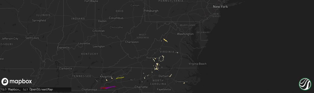
Hail Map in Virginia on March 20, 2012
The weather event in Virginia on March 20, 2012 includes Hail map. 6 states and 125 cities were impacted and suffered possible damage. The total estimated number of properties impacted is 0.
Want more than just the map?
Turn this storm into a full workflow.
- Owner + property data so you know who to knock
- OnDemand branded weather history reports to win the "did we even have hail?" argument
- RoofTrace estimate so reps stop guessing numbers at the door
Bought this map? Upgrade within 7 days and we'll credit the $230. (10-15 min setup call)
Hail
0
Estimated number of impacted properties by a 1.00" hail or larger0
Estimated number of impacted properties by a 1.75" hail or larger0
Estimated number of impacted properties by a 2.50" hail or largerStorm reports in Virginia
Virginia
| Date | Description |
|---|---|
| 03/20/20126:26 PM CDT | Nickel-sized hail with a few stones as large as quarters. |
| 03/20/20125:37 PM CDT | A local report indicates 1.00 inch wind near 4 S LACEY SPRING |
| 03/20/20125:37 PM CDT | A local report indicates 1.50 inch wind near 5 N MASSANUTTEN |
| 03/20/20125:35 PM CDT | A local report indicates 1.00 inch wind near 2 S LACEY SPRING |
| 03/20/20125:34 PM CDT | A local report indicates 1.75 inch wind near 3 SSW LACEY SPRING |
| 03/20/20125:25 PM CDT | A local report indicates 1.00 inch wind near 5 SE SWANSONVILLE |
| 03/20/20125:25 PM CDT | A local report indicates 1.00 inch wind near SURRY HILLS |
| 03/20/20125:15 PM CDT | Lasted until 625 pm edt |
| 03/20/20125:08 PM CDT | A local report indicates 1.00 inch wind near 2 S CLIMAX |
| 03/20/20124:55 PM CDT | A local report indicates 1.00 inch wind near 3 SSW NORTHWEST SMITH M |
| 03/20/20124:50 PM CDT | A local report indicates 1.00 inch wind near SCHOOLFIELD |
| 03/20/20124:45 PM CDT | A local report indicates 1.00 inch wind near DANVILLE |
| 03/20/20124:45 PM CDT | A local report indicates 1.00 inch wind near GILMER TERRACE |
| 03/20/20124:45 PM CDT | Hail lasted 5 minutes. Fell on middle valley road just outside of the town of hardy near west lake corner. No street address available. |
| 03/20/20124:25 PM CDT | Several minutes of nickel sized hail mixed with a few quarter sized. |
| 03/20/20124:06 PM CDT | A local report indicates 1.00 inch wind near 1 SW DAVIS MILL |
| 03/20/20123:45 PM CDT | A local report indicates 1.00 inch wind near 1 SSE HILLSMAN CORNER |
| 03/20/20123:40 PM CDT | A local report indicates 1.00 inch wind near 4 E EVINGTON |
All States Impacted by Hail Map on March 20, 2012
Cities Impacted by Hail Map on March 20, 2012
- McGaheysville, VA
- Keezletown, VA
- Linville, VA
- Broadway, VA
- Shenandoah, VA
- Elkton, VA
- Harrisonburg, VA
- Advance, NC
- Mocksville, NC
- Blanch, NC
- Yanceyville, NC
- Prattsville, AR
- Pelham, NC
- Ruffin, NC
- Providence, NC
- Warren, AR
- Moneta, VA
- Bedford, VA
- New Iberia, LA
- Long Island, VA
- Nathalie, VA
- Wirtz, VA
- Union Hall, VA
- Concord, VA
- Spout Spring, VA
- Appomattox, VA
- Gretna, VA
- Chatham, VA
- Sevierville, TN
- Dandridge, TN
- Rockford, TN
- Knoxville, TN
- Walland, TN
- Townsend, TN
- Mooresville, NC
- Hurt, VA
- Altavista, VA
- Louisburg, NC
- Blairs, VA
- Danville, VA
- Dry Fork, VA
- Hardy, VA
- Bridgewater, VA
- Merryville, LA
- Spring City, TN
- Chocowinity, NC
- Brookneal, VA
- Summerfield, NC
- Eden, NC
- Reidsville, NC
- Sheridan, AR
- Winston Salem, NC
- Martinsville, VA
- Youngsville, NC
- Zebulon, NC
- Vinton, LA
- Henrico, VA
- Cascade, VA
- Kannapolis, NC
- Manakin Sabot, VA
- Lynchburg, VA
- Leola, AR
- El Dorado, AR
- Jersey, AR
- Strong, AR
- Evington, VA
- Lynch Station, VA
- Clinton, TN
- Yadkinville, NC
- Galveston, TX
- Alton, VA
- Granite Falls, NC
- Vesuvius, VA
- Huddleston, VA
- Singer, LA
- Ten Mile, TN
- Morganton, NC
- Keeling, VA
- Buchanan, VA
- Gladys, VA
- Powhatan, VA
- Newton, TX
- Kirbyville, TX
- Grapevine, AR
- Clinton, AR
- Niota, TN
- Hermitage, AR
- Marshall, NC
- Hot Springs, NC
- Burnsville, NC
- Mars Hill, NC
- Del Rio, TN
- Murphy, NC
- Turtletown, TN
- Farner, TN
- Franklin, NC
- Marble, NC
- Sylva, NC
- Topton, NC
- Cullowhee, NC
- Andrews, NC
- Hayesville, NC
- Tuckasegee, NC
- Gordon, TX
- Ranger, TX
- Perrin, TX
- Santo, TX
- Weatherford, TX
- Sunset, TX
- Graford, TX
- Mineral Wells, TX
- Jacksboro, TX
- Paradise, TX
- Poolville, TX
- Springtown, TX
- Mingus, TX
- Forestburg, TX
- Bridgeport, TX
- Chico, TX
- Strawn, TX
- Palo Pinto, TX
- Millsap, TX
- Decatur, TX
- Alvord, TX
- Whitt, TX


