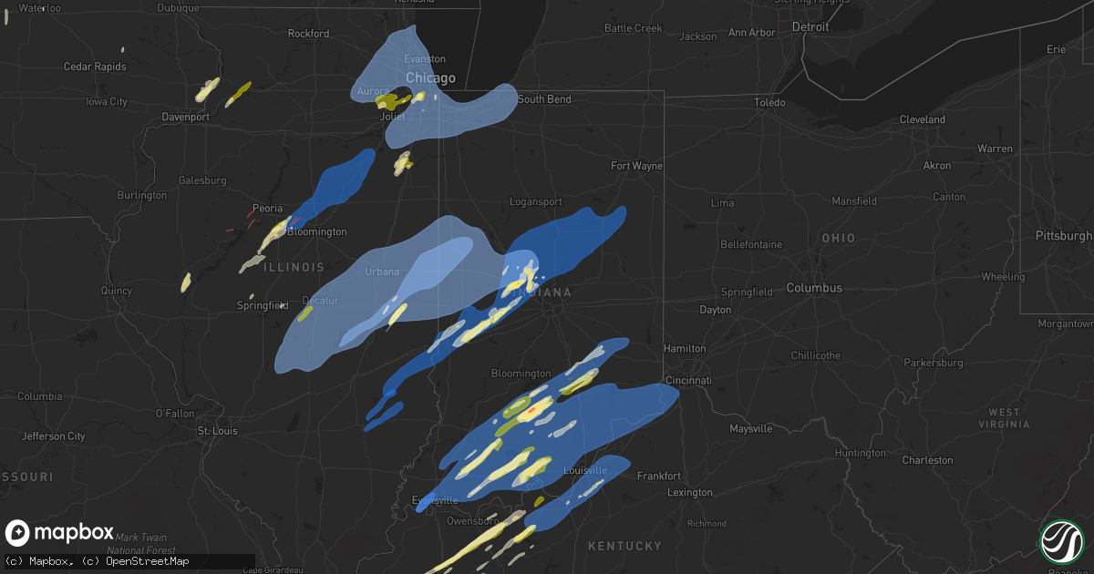
Hail Map in Indiana on March 19, 2025
Get this storm
March 19 map
$229
one time, instant access
Download today. No call, no setup
Keep the $229
Bought the map and want the full workflow? Apply the entire $229 to a subscription within 7 days. None of it is wasted.
Every map, not just this one
This buys you this map. Subscription and you get every map we run, in the markets you choose from a few cities to whole states to nationwide. Plus real-time alerts the moment a storm fires.
Contact data
Name, contact info, occupancy, even credit band for addresses in the footprint. You go from where it hit to who to call.
Become the source they trust
Unlimited branding weather history reports on demand. You already have the documented answer ready for the property owner, and you are the one who showed up with it.
Property data and RoofTrace estimates
Pull up any address you have got, its value and the exact code rules for that jurisdiction, straight from One Click Code. Then RoofTrace estimates the squares, pitch, and roof value, priced the way you price.
Storm reports in Indiana
Indiana
| Date | Description |
|---|---|
| 03/19/20256:58 PM CDT | Power lines downed in the roadway at the intersection of 350 w and west schuetter road in jasper. |
| 03/19/20256:54 PM CDT | Emergency manager relayed report of two outbuildings collapsed and damaged. Time estimated via radar. |
| 03/19/20256:53 PM CDT | Time estimated by radar. |
| 03/19/20256:53 PM CDT | A shed roof was blocking the roadway along 350 w west of jasper. |
| 03/19/20256:52 PM CDT | Additional reports from ema of hanger doors blown in and windows broken at logansport/cass county airport. Time estimated by radar. |
| 03/19/20256:52 PM CDT | Cass county ema reported power poles down and pieces of a barn in the fields near logansport airport. Time estimated by radar. |
| 03/19/20256:50 PM CDT | Trained spotter reports a tree blown down into power lines due to strong straight line winds southeast of waterford at 675 w 400 n in la porte county indiana. |
| 03/19/20256:47 PM CDT | Large pine tree was downed along stewart road west of jasper. Time estimated from radar. |
| 03/19/20256:47 PM CDT | Tree down on power lines along state road 56 west of jasper. |
| 03/19/20256:45 PM CDT | Part of barn roof blown off; fence blown down 1525 e county road 350 n. |
| 03/19/20256:45 PM CDT | Barn destroyed...nearby home damaged by flying debris. |
| 03/19/20256:42 PM CDT | Public reported thunderstorm winds estimated to 65-70 mph with quarter sized hail at 400 west and 900 south. |
| 03/19/20256:42 PM CDT | A local report indicates 1.00 inch wind near 4 W Duff |
| 03/19/20256:41 PM CDT | Time estimated by radar. |
| 03/19/20256:40 PM CDT | A local report indicates 1.00 inch wind near 6 E Spurgeon |
| 03/19/20256:37 PM CDT | Thunderstorm winds blew over semi truck on interstate 65 between mm 156 and mm 157. Time estimated by radar. |
| 03/19/20256:36 PM CDT | Delayed report. Picture of trees down over road. Relayed via social media with time estimated from radar. |
| 03/19/20256:35 PM CDT | Thunderstorm winds downed 9 poles on county road 750 west. Time estimated by radar. |
| 03/19/20256:33 PM CDT | Thunderstorm winds reportedly downed dozens of trees. Time estimated by radar. |
| 03/19/20256:28 PM CDT | Reports of 1.00 inch hail from the northwest side of greencastle where it caused siding damage to the east side of greencastle as reported by ema to greencastle 3.5 ne |
| 03/19/20256:27 PM CDT | Corrects time of previous tstm wnd dmg report from michigan city. Photos passed along from media showing several large downed trees in michigan city. Time estimated by |
| 03/19/20256:25 PM CDT | A local report indicates 1.00 inch wind near Greencastle |
| 03/19/20256:24 PM CDT | Thunderstorm winds downed roof and siding material off of barn across us highway 231 and brick chapel. Possible brief weak tornado. Time estimated by radar. |
| 03/19/20256:24 PM CDT | Corrects previous tstm wnd dmg report from 5 sw bainbridge. Thunderstorm winds downed roof and siding material off of barn across us highway 231 and brick chapel. Time |
| 03/19/20256:18 PM CDT | Multiple reports of thunderstorm winds downing trees and or power poles in crawfordsville including minor roof damage on ladoga road. Time estimated by radar. |
| 03/19/20256:15 PM CDT | Additionally pea to nickel sized hail also reported just north of knightsville. |
| 03/19/20255:59 PM CDT | Thunderstorm wind gust at khuf terre haute regional airport. |
| 03/19/20255:55 PM CDT | A local report indicates 60 MPH wind near 6 W Evansville |
| 03/19/20255:53 PM CDT | Late report. Social media picture of tree on house. Time estimated from radar. |
| 03/19/20255:47 PM CDT | Branches down. Garage collapsed. Roof damage. Power pole damage. Time estimated by radar. Reports from emergency management and social media. |
| 03/19/20255:45 PM CDT | Thunderstorm winds estimated 60-70 mph at terre haute 6.5 n. Torrential rain and pea hail. |
| 03/19/20255:42 PM CDT | Three trees uprooted on houses on forrest dr. Via social media. Time estimated by radar. |
| 03/19/20255:27 PM CDT | Photos passed along from media showing several large downed trees in michigan city. Time estimated by radar. |
| 03/18/20259:44 PM CDT | Large portion of tree down... Causing damage to house roof and porch roof in 300 block of main st. |
| 03/18/20259:43 PM CDT | 1000 block of main street... Car park roof uplifted and damage to small outbuilding. |
| 03/18/20258:55 PM CDT | Delayed report. Poles and trees downed. Relayed via 911 center. Time estimated from radar. |
| 03/18/20258:42 PM CDT | Trees down in the memphis area near memphis blue lick road. Over 500 power outages reported in the area. |
| 03/18/20258:29 PM CDT | Ham radio operator reported a power pole on fire due to lightning strike along with downed power lines in auburn... In. Time estimated by radar. |
| 03/18/20258:29 PM CDT | Ham radio operator |
| 03/18/20258:28 PM CDT | Tree down onto power line in hagerstown. |
| 03/18/20258:25 PM CDT | Wires reported down. Time estimated from radar. |
| 03/18/20258:22 PM CDT | Emergency management reported downed powerlines and a broken utility pole on cr 350 n west of sr 327. |
| 03/18/20258:22 PM CDT | Report relayed of tree limbs down between lane 230 and cr 450 west near jimmerson lake. Time estimated from radar. |
| 03/18/20258:21 PM CDT | Report relayed by em that law enforcement reported tree limbs down on orland road east of cr 400 west. Time estimated via radar. |
| 03/18/20258:17 PM CDT | Trees down on indiana state road 60 at farabee. Time estimated from radar. |
| 03/18/20258:11 PM CDT | Quarter sized hail reported in milltown. |
| 03/18/20258:11 PM CDT | Ham reported. Time estimated by radar. |
| 03/18/20258:08 PM CDT | Quarter sized hail reported in carefree. |
| 03/18/20258:06 PM CDT | Late report of some trees and power lines down in decatur county. Time estimated by radar. |
| 03/18/20258:05 PM CDT | Quarter sized hail was reported near curby. |
| 03/18/20257:59 PM CDT | Thunderstorm wind damage reported on indiana route 9 south of indiana route 46 and on indiana route 46 near hartsville. Possible tornado. Time estimated by radar. |
| 03/18/20257:56 PM CDT | Delayed report. Estimated 6 to 8 inch tree limb snapped over road county road 800n. Time estimated from radar. |
| 03/18/20257:49 PM CDT | Thunderstorm winds downed power lines at 300 south and 350 west. Time estimated by radar. |
| 03/18/20257:49 PM CDT | Delayed report. Tree down over county road 1100n. Time estimated from radar. |
| 03/18/20257:44 PM CDT | An ef-2 tornado with peak wind speeds of 112 mph and path width of 350 yards tracked for 13.55 miles through bartholomew county through 857pm causing damage to well-bui |
| 03/18/20257:41 PM CDT | Late report of thunderstorm wind damage at 3640 west 700 south which continued through rosstown where a barn roof was reportedly blown off and a trailed blown over. Pos |
| 03/18/20257:39 PM CDT | A local report indicates 61 MPH wind near 1 W Spurgeons Corner |
| 03/18/20257:36 PM CDT | Quarter sized hail was reported near taswell. Time estimated by radar. |
| 03/18/20257:29 PM CDT | Multiple trees downed and power lines down along indiana state road 145 south of birdseye. Time estimated from radar. |
| 03/18/20257:28 PM CDT | Delayed report. Power lines over road. Relayed via social media. Time estimated from radar. |
| 03/18/20257:22 PM CDT | Emergency management reports large trees down and damage to a dwelling around 2 miles southwest of akron in fulton county indiana. Time estimated from radar data. |
| 03/18/20257:21 PM CDT | Time estimated by radar. |
| 03/18/20257:20 PM CDT | Emergency management reports large trees down and sheet metal blown around 3 miles southwest of akron in fulton county indiana. Time estimated from radar data. |
| 03/18/20257:18 PM CDT | Thunderstorm winds downed 3 power poles across roadway on howard-miami county line. Time estimated by radar. |
| 03/18/20257:18 PM CDT | Light pole down along industrial park road in ferdinand. |
| 03/18/20257:15 PM CDT | Delayed report. Roof damage to skate rink. Time estimated from radar. |
| 03/18/20257:10 PM CDT | Thunderstorm winds downed tree onto residence at ohio street and virginia street. Also tree on car at park street and blvd. Time estimated by radar. |
| 03/18/20257:04 PM CDT | Time estimated by radar. |
All States Impacted by Hail Map on March 19, 2025
Cities Impacted by Hail Map on March 19, 2025
- Nevada, IA
- Radcliffe, IA
- Roland, IA
- Winterset, IA
- Dike, IA
- Grundy Center, IA
- Van Meter, IA
- Adel, IA
- De Soto, IA
- Dallas Center, IA
- Parkersburg, IA
- Evansdale, IA
- Waterloo, IA
- Granger, IA
- Grimes, IA
- Woodward, IA
- Madrid, IA
- Anamosa, IA
- Le Claire, IA
- Princeton, IA
- Long Grove, IA
- Eldridge, IA
- Camanche, IA
- Cordova, IL
- Clinton, IA
- Fulton, IL
- Erie, IL
- Albany, IL
- De Witt, IA
- Low Moor, IA
- Prophetstown, IL
- Lyndon, IL
- Morrison, IL
- Sterling, IL
- Genoa, IL
- Sycamore, IL
- Hampshire, IL
- Versailles, IL
- Mount Sterling, IL
- Frederick, IL
- Rushville, IL
- Canton, IL
- Manito, IL
- Glasford, IL
- Hanna City, IL
- Mapleton, IL
- Kingston Mines, IL
- Easton, IL
- Petersburg, IL
- Oakford, IL
- Mason City, IL
- San Jose, IL
- Green Valley, IL
- Tremont, IL
- Pleasant Plains, IL
- Delavan, IL
- Hopedale, IL
- Mackinaw, IL
- Morton, IL
- Danvers, IL
- Cantrall, IL
- Athens, IL
- Emden, IL
- Deer Creek, IL
- Mechanicsburg, IL
- Dawson, IL
- Congerville, IL
- Goodfield, IL
- Carlock, IL
- Bloomington, IL
- Hudson, IL
- Secor, IL
- Lexington, IL
- Gridley, IL
- El Paso, IL
- Eureka, IL
- Roanoke, IL
- Sullivan, IL
- Findlay, IL
- Windsor, IL
- Shelbyville, IL
- Gays, IL
- Humboldt, IL
- Arthur, IL
- Mattoon, IL
- Arcola, IL
- Chenoa, IL
- Flanagan, IL
- Pontiac, IL
- Graymont, IL
- Newman, IL
- Camargo, IL
- Villa Grove, IL
- Tuscola, IL
- Oakland, IL
- Hindsboro, IL
- Murdock, IL
- Longview, IL
- Clay City, IL
- Sailor Springs, IL
- Willow Hill, IL
- Newton, IL
- Yale, IL
- Ingraham, IL
- Louisville, IL
- Noble, IL
- Buffalo, IL
- Flora, IL
- Fairbury, IL
- Odell, IL
- Minonk, IL
- Cornell, IL
- Long Point, IL
- Streator, IL
- Blackstone, IL
- Dwight, IL
- Kinsman, IL
- Hidalgo, IL
- Oblong, IL
- Casey, IL
- Dundas, IL
- Emington, IL
- Verona, IL
- Mazon, IL
- Gardner, IL
- Charleston, IL
- Brocton, IL
- Plainfield, IL
- Oswego, IL
- Aurora, IL
- Naperville, IL
- Bolingbrook, IL
- Lockport, IL
- Crest Hill, IL
- Joliet, IL
- Romeoville, IL
- Lemont, IL
- Woodridge, IL
- Lisle, IL
- Downers Grove, IL
- Homer Glen, IL
- Darien, IL
- Willowbrook, IL
- Orland Park, IL
- Ancona, IL
- Dana, IL
- Ransom, IL
- Big Rock, IL
- Plano, IL
- Elburn, IL
- Sugar Grove, IL
- North Aurora, IL
- Montgomery, IL
- Bristol, IL
- Yorkville, IL
- Batavia, IL
- Saint Charles, IL
- Geneva, IL
- South Elgin, IL
- Elgin, IL
- Wasco, IL
- Warrenville, IL
- Mooseheart, IL
- Wayne, IL
- West Chicago, IL
- Bartlett, IL
- Dundee, IL
- Wheaton, IL
- Streamwood, IL
- Roselle, IL
- Glendale Heights, IL
- Glen Ellyn, IL
- Oak Brook, IL
- Lombard, IL
- Bloomingdale, IL
- Hanover Park, IL
- Hoffman Estates, IL
- Winfield, IL
- Carol Stream, IL
- Westmont, IL
- Elk Grove Village, IL
- Medinah, IL
- Itasca, IL
- Carpentersville, IL
- Addison, IL
- Villa Park, IL
- Schaumburg, IL
- Barrington, IL
- Rolling Meadows, IL
- Lake Zurich, IL
- Palatine, IL
- Arlington Heights, IL
- Oak Park, IL
- Wood Dale, IL
- Stone Park, IL
- Hillside, IL
- Berkeley, IL
- Bensenville, IL
- Harwood Heights, IL
- Chicago, IL
- River Grove, IL
- Franklin Park, IL
- Westchester, IL
- Elmwood Park, IL
- Schiller Park, IL
- Broadview, IL
- Melrose Park, IL
- Hines, IL
- Forest Park, IL
- Bellwood, IL
- Des Plaines, IL
- River Forest, IL
- Elmhurst, IL
- Maywood, IL
- Mount Prospect, IL
- Bonfield, IL
- Herscher, IL
- Kankakee, IL
- Chebanse, IL
- Annapolis, IL
- West York, IL
- Martinsville, IL
- Paris, IL
- Marshall, IL
- West Union, IL
- Dennison, IL
- Olney, IL
- West Liberty, IL
- Claremont, IL
- Terre Haute, IN
- West Terre Haute, IN
- Rosedale, IN
- Hume, IL
- Collison, IL
- Fairmount, IL
- Fithian, IL
- Danville, IL
- Muncie, IL
- Allerton, IL
- Homer, IL
- Oakwood, IL
- Broadlands, IL
- Georgetown, IL
- Sidell, IL
- Indianola, IL
- Catlin, IL
- Ridge Farm, IL
- Westville, IL
- Cayuga, IN
- Covington, IN
- Tilton, IL
- Perrysville, IN
- Williamsport, IN
- West Lebanon, IN
- Bismarck, IL
- Alvin, IL
- State Line, IN
- Potomac, IL
- Irving, IL
- Hillsboro, IL
- Butler, IL
- Harvel, IL
- Nokomis, IL
- Morrisonville, IL
- Raymond, IL
- Palmer, IL
- Witt, IL
- Pana, IL
- Owaneco, IL
- Edinburg, IL
- Stonington, IL
- Taylorville, IL
- Rosamond, IL
- Blue Mound, IL
- Moweaqua, IL
- Bingham, IL
- Oconee, IL
- Fillmore, IL
- Assumption, IL
- Ohlman, IL
- Ramsey, IL
- Bourbonnais, IL
- Oak Lawn, IL
- Worth, IL
- Alsip, IL
- Chicago Ridge, IL
- Hometown, IL
- Evergreen Park, IL
- Park Ridge, IL
- Wauconda, IL
- Buffalo Grove, IL
- Mundelein, IL
- Wheeling, IL
- Prospect Heights, IL
- Lincolnwood, IL
- Lake Bluff, IL
- Highland Park, IL
- Niles, IL
- Highwood, IL
- Winnetka, IL
- Vernon Hills, IL
- Libertyville, IL
- Deerfield, IL
- Lake Forest, IL
- Wilmette, IL
- Glenview, IL
- Morton Grove, IL
- North Chicago, IL
- Golf, IL
- Northbrook, IL
- Glencoe, IL
- Skokie, IL
- Lincolnshire, IL
- Great Lakes, IL
- Kenilworth, IL
- Evanston, IL
- Whiting, IN
- Hammond, IN
- Griffith, IN
- Crown Point, IN
- Gary, IN
- East Chicago, IN
- Merrillville, IN
- Hobart, IN
- Schererville, IN
- Highland, IN
- Dyer, IN
- Chicago Heights, IL
- Calumet City, IL
- Saint John, IN
- South Holland, IL
- Riverdale, IL
- Lowell, IN
- Munster, IN
- Cedar Lake, IN
- Dolton, IL
- Lansing, IL
- Crete, IL
- Glenwood, IL
- Thornton, IL
- Homewood, IL
- Harvey, IL
- Steger, IL
- Beecher, IL
- Robbins, IL
- Country Club Hills, IL
- Park Forest, IL
- Crestwood, IL
- Matteson, IL
- Peotone, IL
- Olympia Fields, IL
- Richton Park, IL
- Posen, IL
- Oak Forest, IL
- Flossmoor, IL
- Markham, IL
- Monee, IL
- Midlothian, IL
- Blue Island, IL
- University Park, IL
- Hazel Crest, IL
- Tinley Park, IL
- Frankfort, IL
- Burbank, IL
- Summit Argo, IL
- Hickory Hills, IL
- Willow Springs, IL
- New Lenox, IL
- Palos Heights, IL
- Palos Hills, IL
- Cicero, IL
- Manteno, IL
- Berwyn, IL
- Palos Park, IL
- Manhattan, IL
- Elwood, IL
- Bridgeview, IL
- Wilmington, IL
- Mokena, IL
- Justice, IL
- Channahon, IL
- Hinsdale, IL
- Brookfield, IL
- La Grange Park, IL
- Western Springs, IL
- La Grange, IL
- Riverside, IL
- Lyons, IL
- Clarendon Hills, IL
- Lake Station, IN
- Mount Vernon, IN
- Corydon, KY
- Evansville, IN
- Uniontown, KY
- Princeton, IN
- Fort Branch, IN
- Francisco, IN
- Petersburg, IN
- Oakland City, IN
- Winslow, IN
- Rockville, IN
- Farmersburg, IN
- Brazil, IN
- Bridgeton, IN
- Staunton, IN
- Harmony, IN
- Knightsville, IN
- Carbon, IN
- Greencastle, IN
- Reelsville, IN
- Bainbridge, IN
- Attica, IN
- Veedersburg, IN
- Pine Village, IN
- Otterbein, IN
- Portage, IN
- Chesterton, IN
- Valparaiso, IN
- Michigan City, IN
- Beverly Shores, IN
- Westville, IN
- Wanatah, IN
- Hebron, IN
- Tower Hill, IL
- Boody, IL
- Decatur, IL
- Forsyth, IL
- Macon, IL
- Lakewood, IL
- Herrick, IL
- Cowden, IL
- Dalton City, IL
- Bethany, IL
- Mt Zion, IL
- Velpen, IN
- Otwell, IN
- New Ross, IN
- Jamestown, IN
- Ladoga, IN
- Fillmore, IN
- Stendal, IN
- Lynnville, IN
- Coatesville, IN
- Danville, IN
- North Salem, IN
- Huntingburg, IN
- Shoals, IN
- Loogootee, IN
- La Place, IL
- Monticello, IL
- Milmine, IL
- Maroa, IL
- Oreana, IL
- De Land, IL
- Cisco, IL
- Cerro Gordo, IL
- Lovington, IL
- Argenta, IL
- Hammond, IL
- Bement, IL
- Strasburg, IL
- White Heath, IL
- Mansfield, IL
- Seymour, IL
- Ivesdale, IL
- Atwood, IL
- Sadorus, IL
- Pesotum, IL
- Tolono, IL
- Champaign, IL
- Jasper, IN
- Dubois, IN
- Montgomery, IN
- Cannelburg, IN
- Washington, IN
- Crane, IN
- Williams, IN
- Springville, IN
- Bedford, IN
- Princeton, KY
- Eddyville, KY
- Kuttawa, KY
- Fredonia, KY
- Tennyson, IN
- Lizton, IN
- Santa Claus, IN
- Lincoln City, IN
- Grandview, IN
- Dale, IN
- Mitchell, IN
- Ferdinand, IN
- Chrisney, IN
- Lamar, IN
- Rockport, IN
- Holland, IN
- Avoca, IN
- French Lick, IN
- Saint Anthony, IN
- West Baden Springs, IN
- Gentryville, IN
- Newburgh, IN
- Spurgeon, IN
- Richland, IN
- Chandler, IN
- Boonville, IN
- Elberfeld, IN
- Henderson, KY
- Haubstadt, IN
- Oolitic, IN
- Celestine, IN
- Orleans, IN
- Heltonville, IN
- Schnellville, IN
- Norman, IN
- Birdseye, IN
- Saint Meinrad, IN
- Evanston, IN
- Roachdale, IN
- Crawfordsville, IN
- Pittsboro, IN
- Brownsburg, IN
- Lebanon, IN
- Colfax, IN
- Rossville, IN
- Thorntown, IN
- Frankfort, IN
- Lafayette, IN
- Cutler, IN
- Clarks Hill, IN
- Darlington, IN
- Mulberry, IN
- Advance, IN
- Kirklin, IN
- Whitestown, IN
- Michigantown, IN
- Sheridan, IN
- Westfield, IN
- Zionsville, IN
- Tipton, IN
- Atlanta, IN
- Russiaville, IN
- Goldsmith, IN
- Sharpsville, IN
- Arcadia, IN
- Flora, IN
- Burlington, IN
- Kempton, IN
- Forest, IN
- Kokomo, IN
- Bringhurst, IN
- La Porte, IN
- New Buffalo, MI
- Rolling Prairie, IN
- Three Oaks, MI
- Union Mills, IN
- Union Pier, MI
- Savoy, IL
- Urbana, IL
- Philo, IL
- Thomasboro, IL
- Bondville, IL
- Dewey, IL
- Rantoul, IL
- Mahomet, IL
- Fisher, IL
- Dawson Springs, KY
- Madisonville, KY
- Nebo, KY
- Eckerty, IN
- Bristow, IN
- Taswell, IN
- Sacramento, KY
- Island, KY
- Medora, IN
- English, IN
- Paoli, IN
- Tunnelton, IN
- Campbellsburg, IN
- Brownstown, IN
- Hardinsburg, IN
- Salem, IN
- Saint Croix, IN
- Leopold, IN
- Sulphur, IN
- Tell City, IN
- Marengo, IN
- Branchville, IN
- Grantsburg, IN
- Columbus, IN
- Seymour, IN
- Nashville, IN
- Freetown, IN
- Jonesville, IN
- Elizabethtown, IN
- Vallonia, IN
- Windfall, IN
- Fairmount, IN
- Amboy, IN
- Sweetser, IN
- Marion, IN
- Greentown, IN
- La Fontaine, IN
- Swayzee, IN
- Converse, IN
- Cicero, IN
- Noblesville, IN
- Jonesboro, IN
- Elwood, IN
- Anderson, IN
- Summitville, IN
- Frankton, IN
- Alexandria, IN
- Rossville, IL
- Sidney, IL
- Wellington, IL
- Hoopeston, IL
- Gifford, IL
- Fowler, IN
- Rankin, IL
- Penfield, IL
- Milford, IL
- Royal, IL
- Ogden, IL
- Armstrong, IL
- Ambia, IN
- Saint Joseph, IL
- Chrisman, IL
- Dana, IN
- Clinton, IN
- Henning, IL
- Metcalf, IL
- Boswell, IN
- Hillsdale, IN
- Oxford, IN
- Kingman, IN
- Templeton, IN
- Mecca, IN
- Bloomingdale, IN
- Montezuma, IN
- West Lafayette, IN
- Rumsey, KY
- Livermore, KY
- Utica, KY
- Calhoun, KY
- Hartford, KY
- Centertown, KY
- Philpot, KY
- Whitesville, KY
- Reynolds Station, KY
- Fordsville, KY
- Hawesville, KY
- Cadiz, KY
- Hopkinsville, KY
- Gracey, KY
- Crofton, KY
- Leavenworth, IN
- New Johnsonville, TN
- Cannelton, IN
- Hope, IN
- Westpoint, IN
- Newtown, IN
- Waynetown, IN
- Romney, IN
- Wingate, IN
- Mellott, IN
- Hillsboro, IN
- New Richmond, IN
- Marshall, IN
- Linden, IN
- Waveland, IN
- Alamo, IN
- New Market, IN
- Van Buren, IN
- Gas City, IN
- Upland, IN
- Warren, IN
- Fowlerton, IN
- Gaston, IN
- Montpelier, IN
- Poneto, IN
- Hartford City, IN
- Liberty Center, IN
- Bluffton, IN
- Grammer, IN
- Hartsville, IN
- Westport, IN
- Central City, KY
- Rockport, KY
- Milltown, IN
- Scipio, IN
- Waverly, TN
- McEwen, TN
- Depauw, IN
- Cloverport, KY
- Flat Rock, IN
- Saint Paul, IN
- Greensburg, IN
- Scottsburg, IN
- McHenry, KY
- Hardinsburg, KY
- Beaver Dam, KY
- Horse Branch, KY
- Lewisport, KY
- Erin, TN
- Elkton, KY
- Greenville, KY
- Beechmont, KY
- Beech Creek, KY
- Belton, KY
- Drakesboro, KY
- Browder, KY
- Falls Of Rough, KY
- Harned, KY
- McDaniels, KY
- Westview, KY
- Hudson, KY
- Leitchfield, KY
- North Vernon, IN
- Commiskey, IN
- Fredericksburg, IN
- Crothersville, IN
- Butlerville, IN
- Vernon, IN
- Paris Crossing, IN
- Austin, IN
- Pekin, IN
- Deputy, IN
- Palmyra, IN
- Borden, IN
- Dupont, IN
- New Salisbury, IN
- Ramsey, IN
- Madison, IN
- Underwood, IN
- Holton, IN
- Lexington, IN
- Henryville, IN
- Charlestown, IN
- Corydon, IN
- Marysville, IN
- Georgetown, IN
- Sellersburg, IN
- New Washington, IN
- New Albany, IN
- Greenville, IN
- Bedford, KY
- Hanover, IN
- Milton, KY
- Floyds Knobs, IN
- Memphis, IN
- Otisco, IN
- Nabb, IN
- Bethlehem, IN
- Battletown, KY
- Crandall, IN
- Lanesville, IN
- Central, IN
- Mauckport, IN
- Derby, IN
- Payneville, KY
- Olaton, KY
- Milroy, IN
- Rushville, IN
- Laurel, IN
- Oldenburg, IN
- Morgantown, KY
- Caneyville, KY
- Webster, KY
- Guston, KY
- Brandenburg, KY
- Canaan, IN
- Versailles, IN
- Cross Plains, IN
- Dillsboro, IN
- Vevay, IN
- Bennington, IN
- Carrollton, KY
- Aurora, IN
- Rising Sun, IN
- Moores Hill, IN
- Florence, IN
- Petersburg, KY
- Union, KY
- Patriot, IN
- Ghent, KY
- Burlington, KY
- Warsaw, KY
- Sanders, KY
- Campbellsburg, KY
- Sparta, KY
- West Point, KY
- Brooks, KY
- Shepherdsville, KY
- Irvington, KY
- Custer, KY
- Ekron, KY
- Garfield, KY
- Vine Grove, KY
- Laconia, IN
- Elizabeth, IN
- Fort Knox, KY
- Cecilia, KY
- Muldraugh, KY
- Rineyville, KY
- Louisville, KY
- Fairdale, KY
- Radcliff, KY
- Glenview, KY
- Masonic Home, KY
- Prospect, KY
- Crestwood, KY
- Fisherville, KY
- Simpsonville, KY
- Pewee Valley, KY
- Mount Washington, KY
- Finchville, KY
- Buckner, KY
- La Grange, KY
- Smithfield, KY
- Shelbyville, KY
- Eminence, KY
- Florence, KY
- Walton, KY
- Verona, KY
- Belvidere, NC


