Hail Map in Austin, TX on March 19, 2013
The weather event in Austin, TX on March 19, 2013 includes Hail map. 1 state and 79 cities were impacted and suffered possible damage. The total estimated number of properties impacted is 81,639.
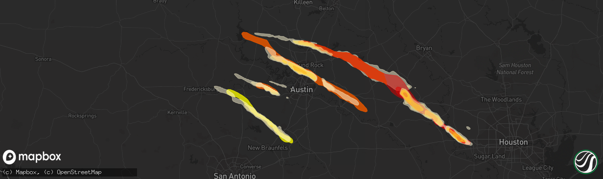
Hail
81,639
Estimated number of impacted properties by a 1.00" hail or larger0
Estimated number of impacted properties by a 1.75" hail or larger0
Estimated number of impacted properties by a 2.50" hail or largerStorm reports in Austin, TX
Austin, TX
| Date | Description |
|---|---|
| 03/19/20132:56 AM CDT | Relayed via partner social media page. |
| 03/19/20132:45 AM CDT | Nickel to ping pong ball sized hail. |
| 03/19/20132:45 AM CDT | A local report indicates 1.00 inch wind near 7 NE AUSTIN |
| 03/19/20132:40 AM CDT | A local report indicates 1.00 inch wind near ANDERSON MILL |
| 03/19/20132:35 AM CDT | A local report indicates 1.50 inch wind near JOLLYVILLE |
All States Impacted by Hail Map on March 19, 2013
All Cities Impacted by Hail Map on March 19, 2013
- Katy, TX
- Sealy, TX
- Brookshire, TX
- Hempstead, TX
- Bluffton, TX
- Georgetown, TX
- Brenham, TX
- Thrall, TX
- Austin, TX
- Ledbetter, TX
- Somerville, TX
- Dime Box, TX
- Lexington, TX
- Lincoln, TX
- Thorndale, TX
- Rockdale, TX
- Caldwell, TX
- Bertram, TX
- Eagle Pass, TX
- Quemado, TX
- Carrizo Springs, TX
- Chappell Hill, TX
- Bleiblerville, TX
- Burton, TX
- Bellville, TX
- Round Mountain, TX
- Tow, TX
- Buchanan Dam, TX
- New Ulm, TX
- La Grange, TX
- Ellinger, TX
- Fayetteville, TX
- Alleyton, TX
- Columbus, TX
- Cat Spring, TX
- Kingsbury, TX
- Martindale, TX
- New Braunfels, TX
- San Marcos, TX
- Blanco, TX
- Wimberley, TX
- Taylor, TX
- Johnson City, TX
- Dripping Springs, TX
- Hye, TX
- East Bernard, TX
- Eagle Lake, TX
- Elgin, TX
- Manor, TX
- Lampasas, TX
- McDade, TX
- Bastrop, TX
- Paige, TX
- Liberty Hill, TX
- Florence, TX
- Burnet, TX
- Pflugerville, TX
- Cedar Park, TX
- Round Rock, TX
- Leander, TX
- Marble Falls, TX
- Hutto, TX
- Granger, TX
- Sugar Land, TX
- Richmond, TX
- Stonewall, TX
- Fredericksburg, TX
- Smithville, TX
- Fischer, TX
- Abbott, TX
- Driftwood, TX
- Spicewood, TX
- San Saba, TX
- Aquilla, TX
- Fulshear, TX
- Carmine, TX
- Bend, TX
- Lometa, TX
- Giddings, TX


