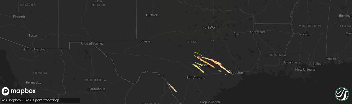
Hail Map in Texas on March 19, 2013
The weather event in Texas on March 19, 2013 includes Hail map. 1 state and 79 cities were impacted and suffered possible damage. The total estimated number of properties impacted is 265,819.
Want more than just the map?
Turn this storm into a full workflow.
- Owner + property data so you know who to knock
- OnDemand branded weather history reports to win the "did we even have hail?" argument
- RoofTrace estimate so reps stop guessing numbers at the door
Bought this map? Upgrade within 7 days and we'll credit the $230. (10-15 min setup call)
Hail
265,819
Estimated number of impacted properties by a 1.00" hail or larger62,531
Estimated number of impacted properties by a 1.75" hail or larger0
Estimated number of impacted properties by a 2.50" hail or largerStorm reports in Texas
Texas
| Date | Description |
|---|---|
| 03/19/20136:52 PM CDT | West of nix one half mile east of river 60 to 70 mph. |
| 03/19/20135:30 AM CDT | Hail near 1 inch and wind gusts estimated to 55 mph. |
| 03/19/20133:26 AM CDT | A local report indicates 1.00 inch wind near 1 WSW CIRCLE D-KC ESTAT |
| 03/19/20133:05 AM CDT | Half dollar size hail on thompson crossing drive. Hail damaged a residential home including a cracked window. |
| 03/19/20133:05 AM CDT | Hail damage to home including cracked window. Near thompson crossing street. |
| 03/19/20132:56 AM CDT | Relayed via partner social media page. |
| 03/19/20132:54 AM CDT | A local report indicates 1.00 inch wind near 14 NW AUSTIN |
| 03/19/20132:53 AM CDT | A local report indicates 1.00 inch wind near PFLUGERVILLE |
| 03/19/20132:45 AM CDT | Nickel to ping pong ball sized hail. |
| 03/19/20132:45 AM CDT | A local report indicates 1.00 inch wind near 7 NE AUSTIN |
| 03/19/20132:45 AM CDT | Half dollar size hail. |
| 03/19/20132:40 AM CDT | A local report indicates 1.00 inch wind near ANDERSON MILL |
| 03/19/20132:35 AM CDT | Small tree limbs down. |
| 03/19/20132:35 AM CDT | A local report indicates 1.50 inch wind near JOLLYVILLE |
| 03/19/20132:25 AM CDT | Golf ball size hail blew out windows in apartment complex. |
| 03/19/20132:20 AM CDT | Golf ball size hail blew out apartment complex windows. Different diameter hail completely covered the ground and measured six inches deep. |
| 03/19/20131:58 AM CDT | A local report indicates 67 MPH wind near BURNET |
| 03/19/20131:50 AM CDT | A local report indicates 1.00 inch wind near 2 W BURNET |
| 03/19/20131:50 AM CDT | Golf ball size hail was reported at the sheriffs office. Reports of roof and window damage across bellville. |
| 03/19/20131:45 AM CDT | Nickel to quarter sized hail. |
| 03/19/20131:14 AM CDT | Golf ball size hail |
| 03/19/20131:08 AM CDT | Winds were strong enough to nearly blow spotters vehicle off the road. |
| 03/19/20131:08 AM CDT | Ping pong size hail |
| 03/19/20131:01 AM CDT | Ping pong size hail. This storms southern flank later produced nickel to just under quarter size hail that fell 20 to 30 minutes in the brenham area. Five hours later t |
| 03/19/20131:01 AM CDT | Reported ping pong ball size hail 8 miles wnw of somerville. |
| 03/19/201312:58 AM CDT | Quarter size hail was reported via the spotternetwork. |
| 03/19/201312:42 AM CDT | A local report indicates 2.00 inch wind near 12 WSW CALDWELL |
| 03/19/201312:40 AM CDT | A local report indicates 1.00 inch wind near SAN MARCOS |
| 03/19/201312:30 AM CDT | A local report indicates 1.00 inch wind near 7 SSE WIMBERLEY |
| 03/19/201312:28 AM CDT | Dents to cars |
| 03/19/201312:25 AM CDT | Hail stones covered the ground. |
| 03/19/201312:25 AM CDT | A local report indicates 1.50 inch wind near 1 W LEXINGTON |
| 03/19/201312:23 AM CDT | A local report indicates 1.75 inch wind near LEXINGTON |
| 03/19/201312:20 AM CDT | Hail busted out the passenger side window of their car |
| 03/18/201311:40 PM CDT | A local report indicates 1.00 inch wind near 1 NNW TAYLOR |
| 03/18/201311:33 PM CDT | A local report indicates 1.00 inch wind near 9 E GEORGETOWN |
| 03/18/201311:30 PM CDT | A local report indicates 1.00 inch wind near 4 E GEORGETOWN |
| 03/18/201311:20 PM CDT | Mostly pea but some quarter size hail. |
| 03/18/201311:15 PM CDT | A local report indicates 1.50 inch wind near 5 N DRIPPING SPRINGS |
| 03/18/201311:14 PM CDT | A local report indicates 1.00 inch wind near GEORGETOWN |
| 03/18/201311:10 PM CDT | A local report indicates 1.50 inch wind near SUN CITY |
| 03/18/20138:19 PM CDT | A local report indicates 1.00 inch wind near 7 WNW FLORENCE |
All States Impacted by Hail Map on March 19, 2013
Cities Impacted by Hail Map on March 19, 2013
- Katy, TX
- Sealy, TX
- Brookshire, TX
- Hempstead, TX
- Bluffton, TX
- Georgetown, TX
- Brenham, TX
- Thrall, TX
- Austin, TX
- Ledbetter, TX
- Somerville, TX
- Dime Box, TX
- Lexington, TX
- Lincoln, TX
- Thorndale, TX
- Rockdale, TX
- Caldwell, TX
- Bertram, TX
- Eagle Pass, TX
- Quemado, TX
- Carrizo Springs, TX
- Chappell Hill, TX
- Bleiblerville, TX
- Burton, TX
- Bellville, TX
- Round Mountain, TX
- Tow, TX
- Buchanan Dam, TX
- New Ulm, TX
- La Grange, TX
- Ellinger, TX
- Fayetteville, TX
- Alleyton, TX
- Columbus, TX
- Cat Spring, TX
- Kingsbury, TX
- Martindale, TX
- New Braunfels, TX
- San Marcos, TX
- Blanco, TX
- Wimberley, TX
- Taylor, TX
- Johnson City, TX
- Dripping Springs, TX
- Hye, TX
- East Bernard, TX
- Eagle Lake, TX
- Elgin, TX
- Manor, TX
- Lampasas, TX
- McDade, TX
- Bastrop, TX
- Paige, TX
- Liberty Hill, TX
- Florence, TX
- Burnet, TX
- Pflugerville, TX
- Cedar Park, TX
- Round Rock, TX
- Leander, TX
- Marble Falls, TX
- Hutto, TX
- Granger, TX
- Sugar Land, TX
- Richmond, TX
- Stonewall, TX
- Fredericksburg, TX
- Smithville, TX
- Fischer, TX
- Abbott, TX
- Driftwood, TX
- Spicewood, TX
- San Saba, TX
- Aquilla, TX
- Fulshear, TX
- Carmine, TX
- Bend, TX
- Lometa, TX
- Giddings, TX


