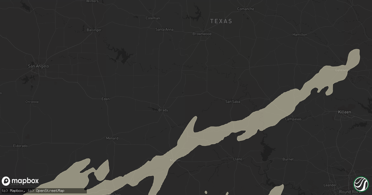
Hail Map in Kerrville, TX on March 19, 2012
Get this storm
March 19 map
$229
one time, instant access
Download today. No call, no setup
Keep the $229
Bought the map and want the full workflow? Apply the entire $229 to a subscription within 7 days. None of it is wasted.
Every map, not just this one
This buys you this map. Subscription and you get every map we run, in the markets you choose from a few cities to whole states to nationwide. Plus real-time alerts the moment a storm fires.
Contact data
Name, contact info, occupancy, even credit band for addresses in the footprint. You go from where it hit to who to call.
Become the source they trust
Unlimited branding weather history reports on demand. You already have the documented answer ready for the property owner, and you are the one who showed up with it.
Property data and RoofTrace estimates
Pull up any address you have got, its value and the exact code rules for that jurisdiction, straight from One Click Code. Then RoofTrace estimates the squares, pitch, and roof value, priced the way you price.
Storm reports in Kerrville, TX
Kerrville, TX
| Date | Description |
|---|---|
| 03/18/201210:40 PM CDT | 4.70 in rain. Hail fell fo about an hour. Mostly pea to dime size with golf ball mixed in. |
| 03/18/20128:15 PM CDT | Golfball hail reported near upper turtle creek 6 1 2 miles west of highway 16. |
All States Impacted by Hail Map on March 19, 2012
All Cities Impacted by Hail Map on March 19, 2012
- Rocksprings, TX
- Fort Hood, TX
- Camp Wood, TX
- Barksdale, TX
- Bridgeport, TX
- Dilley, TX
- Cotulla, TX
- Pearsall, TX
- Asherton, TX
- La Pryor, TX
- Utopia, TX
- Gatesville, TX
- New Matamoras, OH
- Junction, TX
- Sonora, TX
- Del Rio, TX
- Menard, TX
- West Salem, OH
- La Coste, TX
- Lytle, TX
- Atascosa, TX
- Natalia, TX
- Medina, TX
- Kerrville, TX
- Oglesby, TX
- Catarina, TX
- Brady, TX
- Tishomingo, OK
- Mill Creek, OK
- Fairmont, NC
- Nichols, SC
- Fair Bluff, NC
- Silver Lake, MN
- Hunt, TX
- Ingram, TX
- Elkton, SD
- Vanderpool, TX
- San Antonio, TX
- McFall, MO
- New Hampton, MO
- Bethany, MO
- Pleasanton, TX
- Jourdanton, TX
- Eagle Pass, TX
- Quemado, TX
- Encinal, TX
- Valley Mills, TX
- Aquilla, TX
- Clifton, TX
- China Spring, TX
- Johnson City, TX
- Stonewall, TX
- Hye, TX
- Batesville, TX
- Carrizo Springs, TX
- Abilene, TX
- Brownwood, TX
- Sabinal, TX
- Muenster, TX
- Gainesville, TX
- Eden, TX
- Paint Rock, TX
- Leakey, TX
- Laredo, TX
- Ivanhoe, MN
- Hendricks, MN
- Lake Benton, MN
- Canby, MN
- D Hanis, TX
- Indianola, OK
- Crawford, TX
- Rowena, TX
- San Saba, TX
- Pontotoc, TX
- Mason, TX
- Cherokee, TX
- Checotah, OK
- San Angelo, TX
- Telephone, TX
- Flandreau, SD
- Tilden, TX
- Calliham, TX
- Galion, OH
- Caledonia, OH
- Bucyrus, OH
- Glencoe, MN
- Cokato, MN
- Uvalde, TX
- Decatur, TX
- Rhome, TX
- Fredericksburg, TX
- Fredonia, TX
- Knippa, TX
- Tarpley, TX
- Copperas Cove, TX
- Bandera, TX
- Willow City, TX
- Valley Spring, TX
- Concan, TX
- Moore, TX
- Rio Frio, TX
- Jbsa Lackland, TX
- Art, TX
- Brackettville, TX
- Devine, TX
- Center Point, TX
- Lampasas, TX
- Rio Medina, TX
- Hondo, TX
- Boerne, TX
- Mountain Home, TX
- London, TX
- Purmela, TX
- Lometa, TX
- Bend, TX
- Blanco, TX
- Pipe Creek, TX
- Yancey, TX
- Voca, TX
- Comfort, TX
- Mico, TX
- Harper, TX
- Crystal City, TX
- Comstock, TX
- Loris, SC
- Galivants Ferry, SC
- Trent, SD
- York, NE
- McCool Junction, NE
- Fairmont, NE
- Whitefield, OK
- Marble Falls, TX
- Horseshoe Bay, TX
- Round Mountain, TX
- Burnet, TX
- Graysville, OH
- Gordon, TX
- Marion, OH
- Kinta, OK
- Quinton, OK
- Stigler, OK
- Porum, OK
- Dell Rapids, SD
- Egan, SD
- Rochelle, TX
- Conway, SC
- Petersburg, ND
- Niagara, ND
- Santo, TX
- Poolville, TX
- Hebron, IN
- Buckhannon, WV
- Lost Creek, WV
- Marietta, OK
- Santa Anna, TX
- Thackerville, OK
- Gorman, TX
- Overbrook, OK
- Ardmore, OK
- Rising Star, TX
- Strawn, TX
- Ranger, TX
- Saint Jo, TX
- Paradise, TX
- Palo Pinto, TX
- Graford, TX
- Carbon, TX
- Mannsville, OK
- Eastland, TX
- Millsap, TX
- Jacksboro, TX
- Weatherford, TX
- Whitt, TX
- Alvord, TX
- Mingus, TX
- Burneyville, OK
- Lindsay, TX
- Mineral Wells, TX
- Springtown, TX
- Perrin, TX
- Chico, TX
- Era, TX
- Sunset, TX
- Forestburg, TX
- Desdemona, TX
- Rosston, TX
- Moody, TX
- Harpster, OH
- Upper Sandusky, OH
- Orrum, NC
- Evergreen, NC
- Saint Marys, WV
- Parkersburg, WV
- Waverly, WV
- Williamstown, WV
- Nevada, OH
- Porter, MN
- Arco, MN
- Roosevelt, TX
- Bertram, TX
- Boyd, TX
- Krum, TX
- Newark, TX
- Azle, TX
- Sistersville, WV
- Byers, TX
- Melvin, TX
- Kerens, TX
- Vancourt, TX
- Eola, TX
- Millersview, TX
- Allen, OK
- Ada, OK
- Volga, WV
- Kempner, TX
- Kenedy, TX
- Walkerton, IN
- Hamlet, IN
- Killeen, TX
- Talpa, TX
- Valera, TX
- Voss, TX
- Ballinger, TX
- Charlotte, TX
- Milford, TX
- Eagleville, MO
- Hatfield, MO
- Pattonsburg, MO
- Martinsville, MO
- Ridgeway, MO
- Denver, MO
- Albany, MO
- Jeromesville, OH
- Green Sea, SC
- Hanna, IN
- Merkel, TX
- Stonewall, OK
- Garretson, SD
- Mount Calm, TX
- Sterling City, TX
- Westbrook, TX
- Mertens, TX
- Shiloh, OH
- Mansfield, OH
- Buchanan Dam, TX
- Kingsland, TX
- Llano, TX
- Stringtown, OK
- Big Wells, TX
- Caddo, OK
- Bennington, OK
- Bokchito, OK
- Aubrey, TX
- Hext, TX
- Bigfoot, TX
- Fleming, OH
- Frost, TX
- Penelope, TX
- Waco, TX
- Coleman, TX
- Milburn, OK
- Mankato, KS
- Seymour, TX
- Prairie Hill, TX
- Georgetown, TX
- Florence, TX
- Roby, TX
- Ong, NE
- Eldorado, TX
- Fowlerton, TX
- Honey Grove, TX
- Aledo, TX
- Aynor, SC
- Helotes, TX
- Mccurtain, OK
- Polk, OH
- Temple, OK
- Garden City, TX
- Liberty Hill, TX
- Prosper, TX
- Cutler, OH
- Vincent, OH
- Waterford, OH
- McGregor, TX
- Madison, MN
- Barnesville, MN
- Loving, TX
- Atoka, OK
- Pittsburg, OK
- Ponder, TX
- Ozona, TX
- Vesuvius, VA
- Fairfield, VA
- Pipestone, MN
- La Crosse, IN
- Shelby, OH
- Petrolia, TX
- Waurika, OK
- Red Oak, OK
- Webbers Falls, OK
- Wilburton, OK
- Little Elm, TX
- Trinidad, TX
- Mabank, TX
- Woodway, TX
- Friendly, WV
- Little Hocking, OH
- Grant City, MO
- Wall, TX
- Norway, KS
- Whitsett, TX
- Campbellton, TX
- Ashland, OH
- Graham, TX
- Petroleum, WV
- Vienna, WV
- El Indio, TX
- Miles, TX
- Athens, OH
- Briggs, TX
- Walters, OK
- Richland Springs, TX
- Emory, TX
- Brashear, TX
- Sulphur Springs, TX
- Morral, OH
- Terrell, TX
- Exeter, NE
- Mcalester, OK
- Shickley, NE
- Geneva, NE
- Christoval, TX
- Olney, TX
- Marietta, OH
- Elkhart, TX
- Tow, TX
- Doss, TX
- Christine, TX
- Poteet, TX
- Three Rivers, TX
- Karnes City, TX
- Hutchinson, MN
- Oak Island, NC
- Southport, NC


