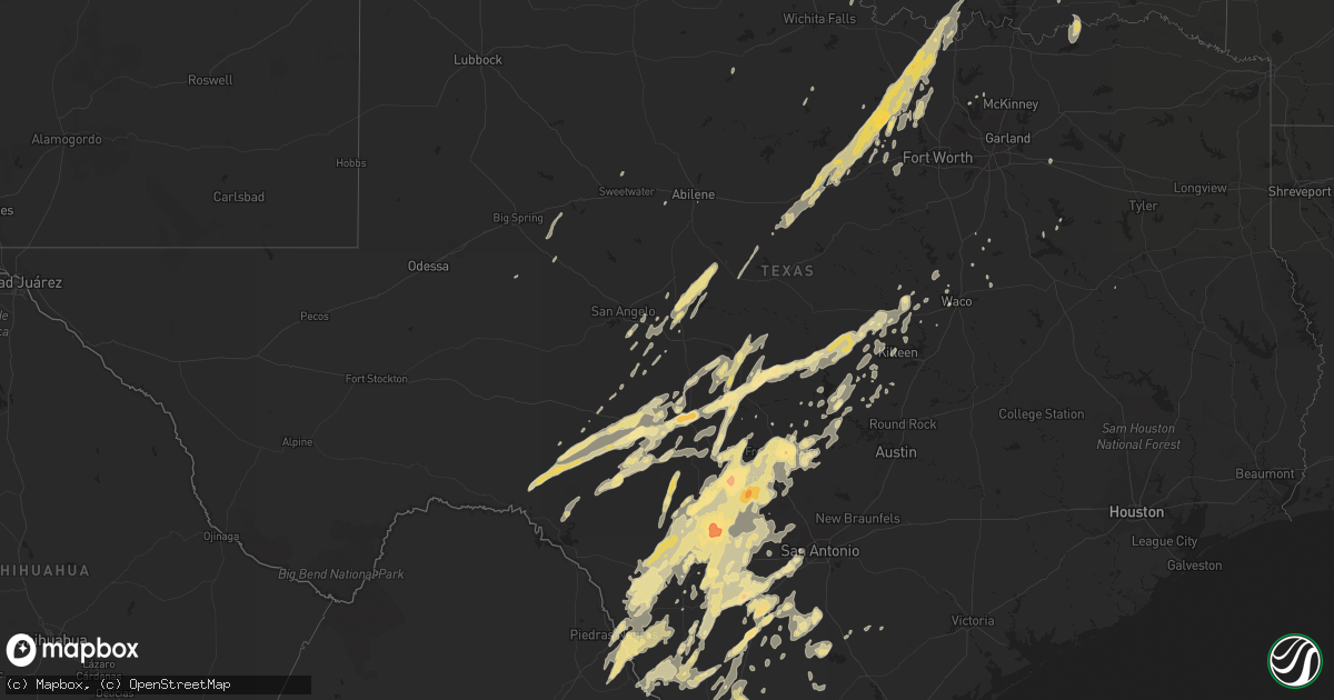
Hail Map in Texas on March 19, 2012
Get this storm
March 19 map
$229
one time, instant access
Download today. No call, no setup
Keep the $229
Bought the map and want the full workflow? Apply the entire $229 to a subscription within 7 days. None of it is wasted.
Every map, not just this one
This buys you this map. Subscription and you get every map we run, in the markets you choose from a few cities to whole states to nationwide. Plus real-time alerts the moment a storm fires.
Contact data
Name, contact info, occupancy, even credit band for addresses in the footprint. You go from where it hit to who to call.
Become the source they trust
Unlimited branding weather history reports on demand. You already have the documented answer ready for the property owner, and you are the one who showed up with it.
Property data and RoofTrace estimates
Pull up any address you have got, its value and the exact code rules for that jurisdiction, straight from One Click Code. Then RoofTrace estimates the squares, pitch, and roof value, priced the way you price.
Storm reports in Texas
Texas
| Date | Description |
|---|---|
| 03/19/20126:58 PM CDT | Hail up to the size of quarters nearly covering the ground. |
| 03/19/20126:54 PM CDT | A local report indicates 1.00 inch wind near 4 N MOUNTAIN HOME |
| 03/19/20126:46 PM CDT | Damage to pickup on fm1582 |
| 03/19/20126:39 PM CDT | Intersection of us57 and fm140 wall cloud went over house |
| 03/19/20126:35 PM CDT | A local report indicates 1.75 inch wind near 2 N LEAKEY |
| 03/19/20126:25 PM CDT | A local report indicates 1.75 inch wind near 3 NE DILLEY |
| 03/19/20126:13 PM CDT | A local report indicates 1.75 inch wind near 2 N PONTOTOC |
| 03/19/20126:12 PM CDT | Quarter up to golfball hail in utopia. |
| 03/19/20126:03 PM CDT | A local report indicates 1.75 inch wind near 2 SE FREDONIA |
| 03/19/20125:32 PM CDT | Golfball size hail reported 4 miles south of highway 90 near knippa. |
| 03/19/20125:27 PM CDT | A local report indicates 1.75 inch wind near 8 S STREETER |
| 03/19/20125:16 PM CDT | A local report indicates 1.00 inch wind near 7 SSE LONDON |
| 03/19/20125:10 PM CDT | Four wooden high tension power poles snapped off at the base along us 377. |
| 03/19/20124:48 PM CDT | One vehicle was dented by this hail. |
| 03/19/20124:02 PM CDT | Reported by traveler via local radio station. Time was estimated per radar. |
| 03/19/20123:30 PM CDT | Public reported 1 inch hail in poolville |
| 03/19/20123:23 PM CDT | A few golfballs mixed with mostly dime and nickel hail |
| 03/19/20123:12 PM CDT | Quarter size hail was reported 4 miles east of the intersection of the caverns of sonora road and rr 189. |
| 03/19/20123:10 PM CDT | A local report indicates 1.00 inch wind near 12 NE JUNO |
| 03/19/20122:25 PM CDT | Spotter reports quarters in thurber |
| 03/19/201212:28 PM CDT | *** 3 inj *** tornado touched down approximately 2 miles ene of gardendale and translated ne for approximately 1 mile. Maximum width approximately 50 yards. A barn...a |
| 03/19/20124:58 AM CDT | Tree down on hwy 155 north between gilmer and diana |
| 03/19/20123:30 AM CDT | Reports of several trees down...as well as one light pole. Reports of roof and structural damage to several buildings in the downtown area. |
| 03/19/20123:27 AM CDT | Nws storm survey concluded a downburst occurred in george west with winds estimated between 60-80 mph. The most significant damage occurred along and east of hwy 281 be |
| 03/19/20122:15 AM CDT | Multiple trees down |
| 03/19/20122:08 AM CDT | A large tree was blocking fm 908 south of rockdale. |
| 03/19/20121:59 AM CDT | Large tree limbs were blown down and blocked the roadway at the intersection of fm 1600 and cr 218. |
| 03/19/20121:20 AM CDT | A local report indicates 1.00 inch wind near 1 SSW CARRIZO SPRINGS |
| 03/19/20121:10 AM CDT | Trees reported down inside and outside mineola city limits by mineola pd. |
| 03/19/201212:20 AM CDT | Large trees were knocked down near cr 1256 and highway 19 |
| 03/18/201210:41 PM CDT | 2 inch hail east of fredericksburg near highway 290 reported by spotter. |
| 03/18/201210:41 PM CDT | Report relayed by broadcast media of golfball size hail in stonewall. |
| 03/18/201210:40 PM CDT | 4.70 in rain. Hail fell fo about an hour. Mostly pea to dime size with golf ball mixed in. |
| 03/18/201210:34 PM CDT | A local report indicates 1.00 inch wind near 3 SE FREDERICKSBURG |
| 03/18/201210:00 PM CDT | Hail ranged in size from pea to golf ball size |
| 03/18/201210:00 PM CDT | 2.04 inches of rainfall also |
| 03/18/20129:40 PM CDT | Hail reported on us highway 87 5 miles sse of brady. |
| 03/18/20129:20 PM CDT | A local report indicates 2.50 inch wind near UTOPIA |
| 03/18/20129:05 PM CDT | A local report indicates 1.25 inch wind near 3 S CONCAN |
| 03/18/20128:45 PM CDT | Pd reports 1 inch hail |
| 03/18/20128:30 PM CDT | Golfball size hail. |
| 03/18/20128:30 PM CDT | Possible tornado damage of 6 homes on ted williams and obrien road...and ladd road. Two non-life threatening injuries were reported. |
| 03/18/20128:29 PM CDT | A local report indicates 1.75 inch wind near 3 W INGRAM |
| 03/18/20128:28 PM CDT | A local report indicates 1.00 inch wind near INGRAM |
| 03/18/20128:20 PM CDT | Powerlines knocked down at county road 664 and 5710 near devine. |
| 03/18/20128:15 PM CDT | Golfball hail reported near upper turtle creek 6 1 2 miles west of highway 16. |
| 03/18/20128:15 PM CDT | Walnut size to near baseball size hail. |
| 03/18/20128:10 PM CDT | Inch to inch and three quarter size hail. |
| 03/18/20128:06 PM CDT | Power flashes and overturned semi trailer at i-35 mile marker 127. |
| 03/18/20128:00 PM CDT | Pea to golfball size hail with some damage. |
| 03/18/20127:28 PM CDT | Quarter sized hail 1 n of city of lampasas |
| 03/18/20127:26 PM CDT | A local report indicates 1.75 inch wind near DILLEY |
| 03/18/20127:25 PM CDT | Quarter size hail 1 n of city of lampasas at airport |
| 03/18/20127:12 PM CDT | A local report indicates 1.75 inch wind near LOST MAPLES STATE PARK |
| 03/18/20127:00 PM CDT | Golfball size hail along with 2 inches of rainfall in less than an hour. |
All States Impacted by Hail Map on March 19, 2012
Cities Impacted by Hail Map on March 19, 2012
- Rocksprings, TX
- Fort Hood, TX
- Camp Wood, TX
- Barksdale, TX
- Bridgeport, TX
- Dilley, TX
- Cotulla, TX
- Pearsall, TX
- Asherton, TX
- La Pryor, TX
- Utopia, TX
- Gatesville, TX
- New Matamoras, OH
- Junction, TX
- Sonora, TX
- Del Rio, TX
- Menard, TX
- West Salem, OH
- La Coste, TX
- Lytle, TX
- Atascosa, TX
- Natalia, TX
- Medina, TX
- Kerrville, TX
- Oglesby, TX
- Catarina, TX
- Brady, TX
- Tishomingo, OK
- Mill Creek, OK
- Fairmont, NC
- Nichols, SC
- Fair Bluff, NC
- Silver Lake, MN
- Hunt, TX
- Ingram, TX
- Elkton, SD
- Vanderpool, TX
- San Antonio, TX
- McFall, MO
- New Hampton, MO
- Bethany, MO
- Pleasanton, TX
- Jourdanton, TX
- Eagle Pass, TX
- Quemado, TX
- Encinal, TX
- Valley Mills, TX
- Aquilla, TX
- Clifton, TX
- China Spring, TX
- Johnson City, TX
- Stonewall, TX
- Hye, TX
- Batesville, TX
- Carrizo Springs, TX
- Abilene, TX
- Brownwood, TX
- Sabinal, TX
- Muenster, TX
- Gainesville, TX
- Eden, TX
- Paint Rock, TX
- Leakey, TX
- Laredo, TX
- Ivanhoe, MN
- Hendricks, MN
- Lake Benton, MN
- Canby, MN
- D Hanis, TX
- Indianola, OK
- Crawford, TX
- Rowena, TX
- San Saba, TX
- Pontotoc, TX
- Mason, TX
- Cherokee, TX
- Checotah, OK
- San Angelo, TX
- Telephone, TX
- Flandreau, SD
- Tilden, TX
- Calliham, TX
- Galion, OH
- Caledonia, OH
- Bucyrus, OH
- Glencoe, MN
- Cokato, MN
- Uvalde, TX
- Decatur, TX
- Rhome, TX
- Fredericksburg, TX
- Fredonia, TX
- Knippa, TX
- Tarpley, TX
- Copperas Cove, TX
- Bandera, TX
- Willow City, TX
- Valley Spring, TX
- Concan, TX
- Moore, TX
- Rio Frio, TX
- Jbsa Lackland, TX
- Art, TX
- Brackettville, TX
- Devine, TX
- Center Point, TX
- Lampasas, TX
- Rio Medina, TX
- Hondo, TX
- Boerne, TX
- Mountain Home, TX
- London, TX
- Purmela, TX
- Lometa, TX
- Bend, TX
- Blanco, TX
- Pipe Creek, TX
- Yancey, TX
- Voca, TX
- Comfort, TX
- Mico, TX
- Harper, TX
- Crystal City, TX
- Comstock, TX
- Loris, SC
- Galivants Ferry, SC
- Trent, SD
- York, NE
- McCool Junction, NE
- Fairmont, NE
- Whitefield, OK
- Marble Falls, TX
- Horseshoe Bay, TX
- Round Mountain, TX
- Burnet, TX
- Graysville, OH
- Gordon, TX
- Marion, OH
- Kinta, OK
- Quinton, OK
- Stigler, OK
- Porum, OK
- Dell Rapids, SD
- Egan, SD
- Rochelle, TX
- Conway, SC
- Petersburg, ND
- Niagara, ND
- Santo, TX
- Poolville, TX
- Hebron, IN
- Buckhannon, WV
- Lost Creek, WV
- Marietta, OK
- Santa Anna, TX
- Thackerville, OK
- Gorman, TX
- Overbrook, OK
- Ardmore, OK
- Rising Star, TX
- Strawn, TX
- Ranger, TX
- Saint Jo, TX
- Paradise, TX
- Palo Pinto, TX
- Graford, TX
- Carbon, TX
- Mannsville, OK
- Eastland, TX
- Millsap, TX
- Jacksboro, TX
- Weatherford, TX
- Whitt, TX
- Alvord, TX
- Mingus, TX
- Burneyville, OK
- Lindsay, TX
- Mineral Wells, TX
- Springtown, TX
- Perrin, TX
- Chico, TX
- Era, TX
- Sunset, TX
- Forestburg, TX
- Desdemona, TX
- Rosston, TX
- Moody, TX
- Harpster, OH
- Upper Sandusky, OH
- Orrum, NC
- Evergreen, NC
- Saint Marys, WV
- Parkersburg, WV
- Waverly, WV
- Williamstown, WV
- Nevada, OH
- Porter, MN
- Arco, MN
- Roosevelt, TX
- Bertram, TX
- Boyd, TX
- Krum, TX
- Newark, TX
- Azle, TX
- Sistersville, WV
- Byers, TX
- Melvin, TX
- Kerens, TX
- Vancourt, TX
- Eola, TX
- Millersview, TX
- Allen, OK
- Ada, OK
- Volga, WV
- Kempner, TX
- Kenedy, TX
- Walkerton, IN
- Hamlet, IN
- Killeen, TX
- Talpa, TX
- Valera, TX
- Voss, TX
- Ballinger, TX
- Charlotte, TX
- Milford, TX
- Eagleville, MO
- Hatfield, MO
- Pattonsburg, MO
- Martinsville, MO
- Ridgeway, MO
- Denver, MO
- Albany, MO
- Jeromesville, OH
- Green Sea, SC
- Hanna, IN
- Merkel, TX
- Stonewall, OK
- Garretson, SD
- Mount Calm, TX
- Sterling City, TX
- Westbrook, TX
- Mertens, TX
- Shiloh, OH
- Mansfield, OH
- Buchanan Dam, TX
- Kingsland, TX
- Llano, TX
- Stringtown, OK
- Big Wells, TX
- Caddo, OK
- Bennington, OK
- Bokchito, OK
- Aubrey, TX
- Hext, TX
- Bigfoot, TX
- Fleming, OH
- Frost, TX
- Penelope, TX
- Waco, TX
- Coleman, TX
- Milburn, OK
- Mankato, KS
- Seymour, TX
- Prairie Hill, TX
- Georgetown, TX
- Florence, TX
- Roby, TX
- Ong, NE
- Eldorado, TX
- Fowlerton, TX
- Honey Grove, TX
- Aledo, TX
- Aynor, SC
- Helotes, TX
- Mccurtain, OK
- Polk, OH
- Temple, OK
- Garden City, TX
- Liberty Hill, TX
- Prosper, TX
- Cutler, OH
- Vincent, OH
- Waterford, OH
- McGregor, TX
- Madison, MN
- Barnesville, MN
- Loving, TX
- Atoka, OK
- Pittsburg, OK
- Ponder, TX
- Ozona, TX
- Vesuvius, VA
- Fairfield, VA
- Pipestone, MN
- La Crosse, IN
- Shelby, OH
- Petrolia, TX
- Waurika, OK
- Red Oak, OK
- Webbers Falls, OK
- Wilburton, OK
- Little Elm, TX
- Trinidad, TX
- Mabank, TX
- Woodway, TX
- Friendly, WV
- Little Hocking, OH
- Grant City, MO
- Wall, TX
- Norway, KS
- Whitsett, TX
- Campbellton, TX
- Ashland, OH
- Graham, TX
- Petroleum, WV
- Vienna, WV
- El Indio, TX
- Miles, TX
- Athens, OH
- Briggs, TX
- Walters, OK
- Richland Springs, TX
- Emory, TX
- Brashear, TX
- Sulphur Springs, TX
- Morral, OH
- Terrell, TX
- Exeter, NE
- Mcalester, OK
- Shickley, NE
- Geneva, NE
- Christoval, TX
- Olney, TX
- Marietta, OH
- Elkhart, TX
- Tow, TX
- Doss, TX
- Christine, TX
- Poteet, TX
- Three Rivers, TX
- Karnes City, TX
- Hutchinson, MN
- Oak Island, NC
- Southport, NC


