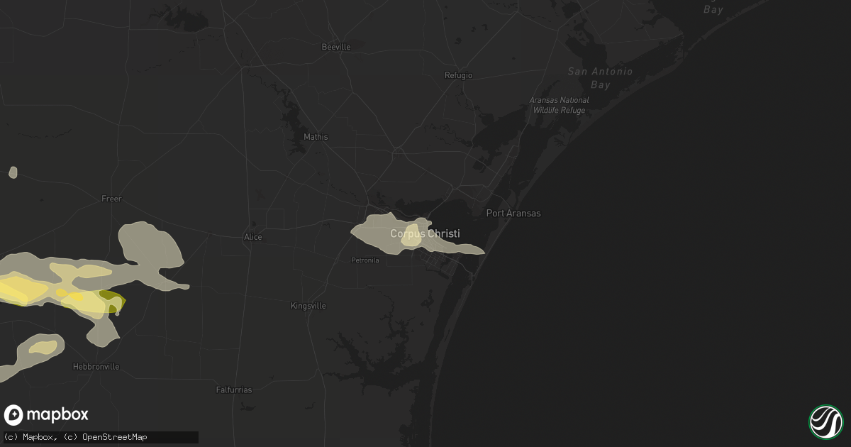
Hail Map in Corpus Christi, TX on March 18, 2016
Get this storm
March 18 map
$229
one time, instant access
Download today. No call, no setup
Keep the $229
Bought the map and want the full workflow? Apply the entire $229 to a subscription within 7 days. None of it is wasted.
Every map, not just this one
This buys you this map. Subscription and you get every map we run, in the markets you choose from a few cities to whole states to nationwide. Plus real-time alerts the moment a storm fires.
Contact data
Name, contact info, occupancy, even credit band for addresses in the footprint. You go from where it hit to who to call.
Become the source they trust
Unlimited branding weather history reports on demand. You already have the documented answer ready for the property owner, and you are the one who showed up with it.
Property data and RoofTrace estimates
Pull up any address you have got, its value and the exact code rules for that jurisdiction, straight from One Click Code. Then RoofTrace estimates the squares, pitch, and roof value, priced the way you price.
Storm reports in Corpus Christi, TX
Corpus Christi, TX
| Date | Description |
|---|---|
| 03/18/20161:31 AM CDT | Kngp asos |
| 03/18/20161:31 AM CDT | Nas corpus christi 60 mph gusts at 131 am. |
| 03/18/20161:23 AM CDT | Power pole snapped with power line down on texas hwy 361 |
| 03/18/20161:06 AM CDT | Weatherflow site along laguna shores measured gust to 53 knots. |
| 03/18/20161:03 AM CDT | Kngp asos |
| 03/18/20161:03 AM CDT | Kngp asas |
| 03/18/201612:56 AM CDT | A local report indicates 70 MPH wind near 3 ESE TEXAS AM UNIVERSI |
| 03/18/201612:56 AM CDT | Kngp asos |
| 03/18/201612:55 AM CDT | Kngp asos |
| 03/18/201612:55 AM CDT | Kngp asos |
| 03/18/201612:50 AM CDT | Kngp asos |
| 03/18/201612:50 AM CDT | Kngp asos |
| 03/18/201612:49 AM CDT | Nearly 50 foot section of chain linked fence at dorothy adkins middle school ripped off fence posts. |
| 03/18/201612:45 AM CDT | Several power poles down and medium sized trees uprooted from intersection of cr 26 and fm 763...north to intersection of fm 665 and fm 763. Damage to horse sheds as we |
| 03/18/201612:45 AM CDT | Weatherflow marine site along corpus christi bay at poenisch park measured gust to 54 knots. |
| 03/18/201612:43 AM CDT | 66 mph thunderstorm wind gust recorded at cabaniss field. |
| 03/18/201612:43 AM CDT | Large tree uprooted at nws corpus chrsiti. Winds estimated 65 to 70 mph. |
| 03/18/201612:42 AM CDT | A local report indicates 68 MPH wind near CORPUS CHRISTI |
| 03/18/201612:40 AM CDT | Roof of metal building at u-haul storage facility blown on neighboring house on french drive near mt. Vernon dr. |
All States Impacted by Hail Map on March 18, 2016
All Cities Impacted by Hail Map on March 18, 2016
- Atoka, OK
- Lettsworth, LA
- Concepcion, TX
- Lockport, LA
- Raceland, LA
- Detroit, TX
- Annona, TX
- Bagwell, TX
- Paris, TX
- Powderly, TX
- Blossom, TX
- Clarksville, TX
- Laredo, TX
- Gainesville, TX
- Marietta, OK
- Asherton, TX
- Carrizo Springs, TX
- Rocksprings, TX
- West Monroe, LA
- Sterlington, LA
- Downsville, LA
- Calhoun, LA
- Monroe, LA
- Collinston, LA
- Hennepin, OK
- Dubberly, LA
- Thibodaux, LA
- Houston, TX
- Yazoo City, MS
- Byars, OK
- Chatham, MS
- Hollandale, MS
- Ryan, OK
- Robstown, TX
- Ingram, TX
- Mountain Home, TX
- Hunt, TX
- Gillett, TX
- Stockdale, TX
- Seguin, TX
- La Vernia, TX
- Kerrville, TX
- Medina, TX
- Marble Falls, TX
- Burnet, TX
- Ragley, LA
- Longville, LA
- Dequincy, LA
- Bertram, TX
- Pauls Valley, OK
- Paoli, OK
- Wayne, OK
- Morse, LA
- Crowley, LA
- Gueydan, LA
- Uvalde, TX
- Brookston, TX
- Haynesville, LA
- Gibsland, LA
- Theriot, LA
- Port O'Connor, TX
- Goliad, TX
- Larose, LA
- Vidor, TX
- Center Point, TX
- Edna, TX
- Brackettville, TX
- Sunset, LA
- Arnaudville, LA
- Opelousas, LA
- Rolling Fork, MS
- Fredericksburg, TX
- Mayersville, MS
- Oak Grove, LA
- Lake Providence, LA
- Port Sulphur, LA
- Buras, LA
- Victoria, TX
- Cotulla, TX
- Duson, LA
- Rayne, LA
- Wilmot, AR
- Lake Village, AR
- Parkdale, AR
- Greenville, MS
- Bonita, LA
- Eudora, AR
- Leland, MS
- Jones, LA
- Bossier City, LA
- Haughton, LA
- Shreveport, LA
- Deridder, LA
- Crystal City, TX
- Harper, TX
- Ville Platte, LA
- Mamou, LA
- Bunkie, LA
- Roma, TX
- Farmerville, LA
- New Braunfels, TX
- San Marcos, TX
- Kingsbury, TX
- Round Mountain, TX
- Johnson City, TX
- Meyersville, TX
- Breaux Bridge, LA
- Saint Martinville, LA
- Horseshoe Bay, TX
- Spicewood, TX
- Kingsland, TX
- San Saba, TX
- Lampasas, TX
- Llano, TX
- Hugo, OK
- Bennington, OK
- Lane, OK
- Caddo, OK
- Boswell, OK
- Caney, OK
- Soper, OK
- Flora, MS
- Batchelor, LA
- Leakey, TX
- Raymond, MS
- Bolton, MS
- Zapata, TX
- Dubach, LA
- Bastrop, LA
- Simsboro, LA
- Choudrant, LA
- Mer Rouge, LA
- Oak Ridge, LA
- Rayville, LA
- Epps, LA
- Pioneer, LA
- Ruston, LA
- Transylvania, LA
- Arcadia, LA
- Grambling, LA
- Ardmore, OK
- Jeanerette, LA
- Lafayette, LA
- Byers, TX
- Arthur City, TX
- Pitkin, LA
- Big Wells, TX
- Eunice, LA
- Lillie, LA
- Summerfield, LA
- Vanderpool, TX
- Floresville, TX
- Adkins, TX
- Camp Wood, TX
- Golden Meadow, LA
- Galliano, LA
- Tishomingo, OK
- Simmesport, LA
- Inez, TX
- Cut Off, LA
- Realitos, TX
- Barksdale, TX
- Driftwood, TX
- Wimberley, TX
- Grant, OK
- Plaquemine, LA
- White Castle, LA
- Plaucheville, LA
- Melville, LA
- Glen Allan, MS
- Del Rio, TX
- Comstock, TX
- Lafitte, LA
- Braithwaite, LA
- Martindale, TX
- Krotz Springs, LA
- Port Barre, LA
- Bulverde, TX
- San Antonio, TX
- Pineville, LA
- Center Point, LA
- Catarina, TX
- Purcell, OK
- Bandera, TX
- Spring Branch, TX
- Barksdale Afb, LA
- Bruni, TX
- San Diego, TX
- Benavides, TX
- San Ygnacio, TX
- Freer, TX
- Hebbronville, TX
- Mirando City, TX
- Spearsville, LA
- Corpus Christi, TX
- Rio Frio, TX
- Encinal, TX
- Mannsville, OK
- Madill, OK
- Youngsville, LA
- Grosse Tete, LA
- Carencro, LA
- Broussard, LA
- Scott, LA
- Tchula, MS
- Lexington, MS
- Jonesville, LA
- Yorktown, TX
- Leander, TX
- Batesville, TX
- Dripping Springs, TX
- Quemado, TX
- Singer, LA
- Gibson, LA
- Fort Towson, OK
- Garvin, OK
- Valliant, OK
- Pickens, MS
- Silver City, MS
- Louise, MS
- Durant, MS
- Junction, TX
- Wilson, OK
- Mill Creek, OK
- Buda, TX
- Kyle, TX
- Anguilla, MS
- South Houston, TX
- Sumner, TX
- Convent, LA
- Eagle Pass, TX
- Milburn, OK
- Gray, LA
- Houma, LA
- Schriever, LA
- Waurika, OK
- Willow City, TX
- Galena Park, TX
- Goodman, MS
- Indianola, MS
- Inverness, MS
- Rio Grande City, TX
- Church Point, LA
- Canyon Lake, TX
- Edgard, LA
- Ringling, OK
- Branch, LA
- Sugartown, LA
- Dry Creek, LA
- Bokchito, OK
- Marion, LA
- Armstrong, TX
- Gheens, LA
- Des Allemands, LA
- Paradis, LA
- Elm Grove, LA
- Basile, LA
- Iota, LA
- Jennings, LA
- Durant, OK
- Stratford, OK
- Chickasha, OK
- D Hanis, TX
- McQueeney, TX
- Marksville, LA
- Comfort, TX
- Benton, MS
- Heflin, LA
- Vinton, LA
- Moreauville, LA
- Evergreen, LA
- Morrow, LA
- Beaumont, TX
- Springer, OK
- Stonewall, TX
- Jbsa Ft Sam Houston, TX
- Converse, TX
- Barataria, LA
- Burneyville, OK
- Alex, OK
- Blanchard, OK
- Lindsay, OK
- Tow, TX
- Saint James, LA
- Nocona, TX
- Sabinal, TX
- Concan, TX
- Foreman, AR
- Ashdown, AR
- Saint Jo, TX
- Leon, OK
- Chauvin, LA
- Dulac, LA
- Ninnekah, OK
- Bernice, LA
- Moorhead, MS
- Richmond, TX
- Lexington, OK
- Merryville, LA
- New Iberia, LA
- Loreauville, LA
- Roanoke, LA
- Mead, OK
- Sugar Land, TX
- Idabel, OK
- Broken Bow, OK
- Buna, TX
- Alice, TX
- Maysville, OK
- Mangham, LA
- Columbia, LA
- Coushatta, LA
- Hall Summit, LA
- Junction City, AR
- Emerson, AR
- Pasadena, TX
- Montegut, LA


