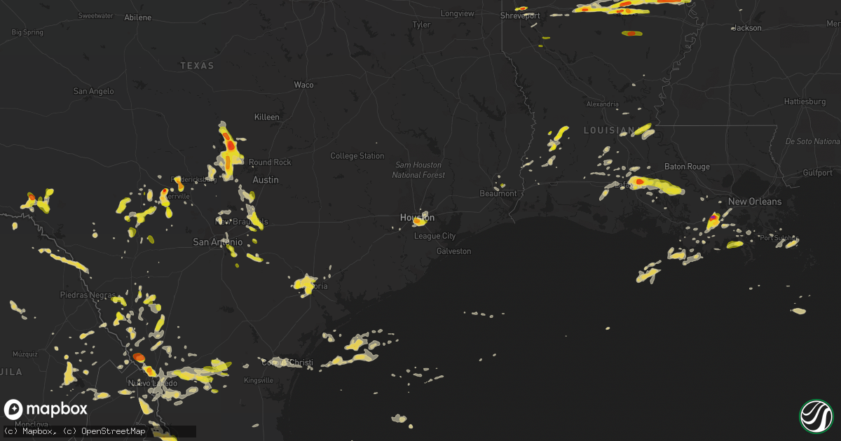
Hail Map on March 18, 2016
Get this storm
March 18 map
$229
one time, instant access
Download today. No call, no setup
Keep the $229
Bought the map and want the full workflow? Apply the entire $229 to a subscription within 7 days. None of it is wasted.
Every map, not just this one
This buys you this map. Subscription and you get every map we run, in the markets you choose from a few cities to whole states to nationwide. Plus real-time alerts the moment a storm fires.
Contact data
Name, contact info, occupancy, even credit band for addresses in the footprint. You go from where it hit to who to call.
Become the source they trust
Unlimited branding weather history reports on demand. You already have the documented answer ready for the property owner, and you are the one who showed up with it.
Property data and RoofTrace estimates
Pull up any address you have got, its value and the exact code rules for that jurisdiction, straight from One Click Code. Then RoofTrace estimates the squares, pitch, and roof value, priced the way you price.
States Impacted by Hail Map on March 18, 2016
Storm reports
Mississippi
| Date | Description |
|---|---|
| 03/18/20169:50 AM CDT | Picture of quarter size hail reported in social media |
Louisiana
| Date | Description |
|---|---|
| 03/18/20166:53 PM CDT | Trained spotter reported quarter sized hail in parks |
| 03/18/20166:48 PM CDT | Public reports golf ball sized hail between breaux bridge and parks. Time from radar. |
| 03/18/20166:45 PM CDT | Public reports golf ball sized hail. |
| 03/18/20165:56 PM CDT | Public reported hail on us 171 north of longville. Time and location estimated by radar. |
| 03/18/20164:59 PM CDT | Broadcast media shared photo of quarter size hail in simmesport. |
| 03/18/20162:55 PM CDT | Public reports ping pong size hail on hwy 165 near old sterlington road intersection. |
| 03/18/20162:41 PM CDT | Ping pong size hail covering the ground in the kiroli park area. |
| 03/18/20162:37 PM CDT | Quarter size hail reported on hwy 546...just north of the interstate 20 exit. |
| 03/18/20162:10 PM CDT | Accumulations of hail up to quarter size |
| 03/18/20162:10 PM CDT | Accumulating hail outside of pioneer ranging in size from quarter to ping pong ball |
| 03/18/20161:46 PM CDT | Quarter size hail reported on cooktown road...1/2 mile north of interstate 20. |
| 03/18/20161:35 PM CDT | Public photo of quarter size hail on knoe-tv facebook page. |
| 03/18/20161:33 PM CDT | Quarter size hail reported at simsboro courthouse. |
| 03/18/20161:30 PM CDT | Golfball size hail reported on hwy 563. |
| 03/18/20161:24 PM CDT | A local report indicates 1.25 inch wind near COLLINSTON |
| 03/18/20161:05 PM CDT | Golfball size hail reported at sterlington high school. |
| 03/18/20161:02 PM CDT | Golfball size hail reported at airline high school. |
| 03/18/20161:00 PM CDT | Quarter size hail reported in rosedale place subdivision. |
| 03/18/201612:11 PM CDT | Hail near the size of a half dollar reported near cut off. |
| 03/18/201610:32 AM CDT | Public report of half dollar hail. |
| 03/18/201610:17 AM CDT | Golfball hail reported on louisiana highway 1 just north of raceland. |
| 03/18/201610:14 AM CDT | Public report and photo via social media |
| 03/18/201610:08 AM CDT | A local report indicates 1.00 inch wind near 5 SE THIBODAUX |
| 03/18/201610:00 AM CDT | Report of quarter sized hail. Time of event estimated by radar. |
| 03/18/20169:58 AM CDT | Public report relayed by the media |
| 03/17/20167:18 PM CDT | Public reports quarter size hail at intersection of us 171 and la 3226 |
| 03/17/20167:08 PM CDT | Public posted photo of golf ball size hail near lake martin rd |
Oklahoma
| Date | Description |
|---|---|
| 03/18/20169:28 AM CDT | Reported on i35. |
| 03/18/20169:11 AM CDT | Mping report. |
Texas
| Date | Description |
|---|---|
| 03/18/20166:57 PM CDT | A local report indicates 1.00 inch wind near 4 NW MARBLE FALLS |
| 03/18/20166:40 PM CDT | A local report indicates 1.00 inch wind near 1 ENE SUNRISE BEACH VIL |
| 03/18/20166:37 PM CDT | Quarter sized hail at highway 225 and richey street in pasadena. |
| 03/18/20166:35 PM CDT | A local report indicates 1.00 inch wind near 1 S MEDINA |
| 03/18/20166:17 PM CDT | A local report indicates 1.00 inch wind near MEDINA |
| 03/18/20166:12 PM CDT | A local report indicates 1.00 inch wind near 2 S ROUND MOUNTAIN |
| 03/18/20166:06 PM CDT | Ping pong sized hail mixed with copious amounts of pea to nickel. |
| 03/18/20165:48 PM CDT | A local report indicates 1.00 inch wind near 5 NE GRANITE SHOALS |
| 03/18/20165:45 PM CDT | Quarter to ping pong sized hail at the medical center in houston. |
| 03/18/20165:40 PM CDT | Hail started out as pea size around 515pm then increased to golf ball size by 540pm |
| 03/18/20165:37 PM CDT | Had dime size hail and straight line wind gusts |
| 03/18/20165:37 PM CDT | A local report indicates 1.00 inch wind near 3 NW MARBLE FALLS |
| 03/18/20165:15 PM CDT | A local report indicates 2.25 inch wind near 6 WSW BURNET |
| 03/18/20165:15 PM CDT | A local report indicates 2.25 inch wind near 4 ENE INKS LAKE STATE P |
| 03/18/20165:12 PM CDT | A local report indicates 1.00 inch wind near BURNET |
| 03/18/20165:10 PM CDT | Nickel to quarter size hail |
| 03/18/20164:52 PM CDT | Public reported nickel to quarter size hail in north vidor |
| 03/18/20164:50 PM CDT | A local report indicates 1.75 inch wind near 4 W HUNT |
| 03/18/20164:50 PM CDT | A local report indicates 1.00 inch wind near 1 E TIVYDALE |
| 03/18/20164:45 PM CDT | A local report indicates 1.50 inch wind near TIVYDALE |
| 03/18/20161:15 PM CDT | Golfball size hail reported at sheriff office. |
| 03/18/201612:35 PM CDT | One inch hail reported in paris |
| 03/18/201612:30 PM CDT | Quarter size hail in paris |
| 03/18/201611:30 AM CDT | Sheriff reports ping pong size hail near the intersection of fm road 2118 and hwy 37...just east of the negley community. |
| 03/18/20161:35 AM CDT | Marine mesonet measured peak gust of 52 knots. |
| 03/18/20161:31 AM CDT | Nas corpus christi 60 mph gusts at 131 am. |
| 03/18/20161:31 AM CDT | Kngp asos |
| 03/18/20161:24 AM CDT | Mariner on board vessel at aransas pass |
| 03/18/20161:23 AM CDT | Power pole snapped with power line down on texas hwy 361 |
| 03/18/20161:12 AM CDT | Roof damage to conoco gas station |
| 03/18/20161:10 AM CDT | Dps corpus christi reports power poles down along highway 77. Also...several semi trucks blown over on highway 77. |
| 03/18/20161:10 AM CDT | Large trees uprooted |
| 03/18/20161:06 AM CDT | Weatherflow site along laguna shores measured gust to 53 knots. |
| 03/18/20161:03 AM CDT | Kngp asas |
| 03/18/20161:03 AM CDT | Kngp asos |
| 03/18/201612:56 AM CDT | Kngp asos |
| 03/18/201612:56 AM CDT | A local report indicates 70 MPH wind near 3 ESE TEXAS AM UNIVERSI |
| 03/18/201612:55 AM CDT | Kngp asos |
| 03/18/201612:55 AM CDT | Kngp asos |
| 03/18/201612:50 AM CDT | Kngp asos |
| 03/18/201612:50 AM CDT | Kngp asos |
| 03/18/201612:49 AM CDT | Nearly 50 foot section of chain linked fence at dorothy adkins middle school ripped off fence posts. |
| 03/18/201612:45 AM CDT | Several power poles down and medium sized trees uprooted from intersection of cr 26 and fm 763...north to intersection of fm 665 and fm 763. Damage to horse sheds as we |
| 03/18/201612:45 AM CDT | Weatherflow marine site along corpus christi bay at poenisch park measured gust to 54 knots. |
| 03/18/201612:43 AM CDT | Large tree uprooted at nws corpus chrsiti. Winds estimated 65 to 70 mph. |
| 03/18/201612:43 AM CDT | 66 mph thunderstorm wind gust recorded at cabaniss field. |
| 03/18/201612:42 AM CDT | A local report indicates 68 MPH wind near CORPUS CHRISTI |
| 03/18/201612:40 AM CDT | Roof of metal building at u-haul storage facility blown on neighboring house on french drive near mt. Vernon dr. |
| 03/18/201612:25 AM CDT | Several power poles blown down from petronila to tierra grande. Minor roof damage to properties. |
| 03/18/201612:20 AM CDT | Large section of metal roofing on out building was peeled away along rt 81. |
| 03/18/201612:19 AM CDT | Four wood telephone poles snapped near base on midway road. |
| 03/18/201612:10 AM CDT | Large trees down. Several moderate to poorly constructed homes suffered roof damage. Estimated 60 to 70 mph wind. |
| 03/18/201612:08 AM CDT | Txdot stated 14 power poles down on fm 70 just south of 665. |
| 03/18/201612:08 AM CDT | Roof damage to barn |
| 03/18/201612:07 AM CDT | Large trees down on property in bishop |
| 03/18/201612:06 AM CDT | Large tree limbs down |
| 03/18/201612:04 AM CDT | Roof damage near n armstrong and ave i. Roof to car port blown off. |
| 03/18/201612:03 AM CDT | A local report indicates 64 MPH wind near ALICE |
| 03/18/201612:01 AM CDT | Trees down in alice along cecilia street |
| 03/17/201611:57 PM CDT | Large tree limbs down |
| 03/17/201611:45 PM CDT | 18-wheeler flipped along hwy 281 and fm 1930 |
| 03/17/201611:43 PM CDT | Carport pulled from ground and destroyed. Large strong fence destroyed. Estimated wind speeds of around 70 mph. |
| 03/17/201611:39 PM CDT | Scattered coverage of large trees downed. Roof damage to homes. |
| 03/17/201611:39 PM CDT | Raws site measured gust of 67 mph. Note ob reported at 0504 utc. Site only reports once an hour and severe gust is for previous entire 60 minute period. Thus...time is |
| 03/17/201611:36 PM CDT | Public reported quarter size hail in benavides. |
| 03/17/201611:30 PM CDT | Large healthy tree uprooted along with other trees downed. Roof damage to home. |
| 03/17/201610:50 PM CDT | 150 ft. Internet tower collapsed on house along bego road |
| 03/17/201610:14 PM CDT | Pictures submitted from public of large to very large trees down. Roof damage also reported to church. Time estimated from radar. |
| 03/17/20169:59 PM CDT | A local report indicates 1.00 inch wind near BIG WELLS |
| 03/17/20169:30 PM CDT | A local report indicates 60 MPH wind near 2 WNW GILLETT |
| 03/17/20168:56 PM CDT | Nickel to quarter size hail |
| 03/17/20168:45 PM CDT | A local report indicates 1.00 inch wind near 7 ESE CALAVERAS LAKE |
| 03/17/20168:44 PM CDT | Golf ball sized hail across the northwest side of laredo. |
| 03/17/20168:32 PM CDT | A local report indicates 1.00 inch wind near 5 NW FLORESVILLE |
| 03/17/20168:30 PM CDT | Lindenwood dr behind united middle school |
| 03/17/20168:30 PM CDT | Hail was covering highway 130 |
| 03/17/20168:27 PM CDT | Mines rd. |
| 03/17/20168:13 PM CDT | On the east side of seguin |
| 03/17/20167:56 PM CDT | A local report indicates 1.00 inch wind near 2 E ZORN |
| 03/17/20167:30 PM CDT | Power lines down |
| 03/17/20167:15 PM CDT | A local report indicates 1.00 inch wind near 2 E LEAKEY |
| 03/17/20167:10 PM CDT | A local report indicates 1.00 inch wind near HAYS CITY |
| 03/17/20167:00 PM CDT | Hail left dents in car |
Cities Impacted by Hail Map on March 18, 2016
- Atoka, OK
- Lettsworth, LA
- Concepcion, TX
- Lockport, LA
- Raceland, LA
- Detroit, TX
- Annona, TX
- Bagwell, TX
- Paris, TX
- Powderly, TX
- Blossom, TX
- Clarksville, TX
- Laredo, TX
- Gainesville, TX
- Marietta, OK
- Asherton, TX
- Carrizo Springs, TX
- Rocksprings, TX
- West Monroe, LA
- Sterlington, LA
- Downsville, LA
- Calhoun, LA
- Monroe, LA
- Collinston, LA
- Hennepin, OK
- Dubberly, LA
- Thibodaux, LA
- Houston, TX
- Yazoo City, MS
- Byars, OK
- Chatham, MS
- Hollandale, MS
- Ryan, OK
- Robstown, TX
- Ingram, TX
- Mountain Home, TX
- Hunt, TX
- Gillett, TX
- Stockdale, TX
- Seguin, TX
- La Vernia, TX
- Kerrville, TX
- Medina, TX
- Marble Falls, TX
- Burnet, TX
- Ragley, LA
- Longville, LA
- Dequincy, LA
- Bertram, TX
- Pauls Valley, OK
- Paoli, OK
- Wayne, OK
- Morse, LA
- Crowley, LA
- Gueydan, LA
- Uvalde, TX
- Brookston, TX
- Haynesville, LA
- Gibsland, LA
- Theriot, LA
- Port O'Connor, TX
- Goliad, TX
- Larose, LA
- Vidor, TX
- Center Point, TX
- Edna, TX
- Brackettville, TX
- Sunset, LA
- Arnaudville, LA
- Opelousas, LA
- Rolling Fork, MS
- Fredericksburg, TX
- Mayersville, MS
- Oak Grove, LA
- Lake Providence, LA
- Port Sulphur, LA
- Buras, LA
- Victoria, TX
- Cotulla, TX
- Duson, LA
- Rayne, LA
- Wilmot, AR
- Lake Village, AR
- Parkdale, AR
- Greenville, MS
- Bonita, LA
- Eudora, AR
- Leland, MS
- Jones, LA
- Bossier City, LA
- Haughton, LA
- Shreveport, LA
- Deridder, LA
- Crystal City, TX
- Harper, TX
- Ville Platte, LA
- Mamou, LA
- Bunkie, LA
- Roma, TX
- Farmerville, LA
- New Braunfels, TX
- San Marcos, TX
- Kingsbury, TX
- Round Mountain, TX
- Johnson City, TX
- Meyersville, TX
- Breaux Bridge, LA
- Saint Martinville, LA
- Horseshoe Bay, TX
- Spicewood, TX
- Kingsland, TX
- San Saba, TX
- Lampasas, TX
- Llano, TX
- Hugo, OK
- Bennington, OK
- Lane, OK
- Caddo, OK
- Boswell, OK
- Caney, OK
- Soper, OK
- Flora, MS
- Batchelor, LA
- Leakey, TX
- Raymond, MS
- Bolton, MS
- Zapata, TX
- Dubach, LA
- Bastrop, LA
- Simsboro, LA
- Choudrant, LA
- Mer Rouge, LA
- Oak Ridge, LA
- Rayville, LA
- Epps, LA
- Pioneer, LA
- Ruston, LA
- Transylvania, LA
- Arcadia, LA
- Grambling, LA
- Ardmore, OK
- Jeanerette, LA
- Lafayette, LA
- Byers, TX
- Arthur City, TX
- Pitkin, LA
- Big Wells, TX
- Eunice, LA
- Lillie, LA
- Summerfield, LA
- Vanderpool, TX
- Floresville, TX
- Adkins, TX
- Camp Wood, TX
- Golden Meadow, LA
- Galliano, LA
- Tishomingo, OK
- Simmesport, LA
- Inez, TX
- Cut Off, LA
- Realitos, TX
- Barksdale, TX
- Driftwood, TX
- Wimberley, TX
- Grant, OK
- Plaquemine, LA
- White Castle, LA
- Plaucheville, LA
- Melville, LA
- Glen Allan, MS
- Del Rio, TX
- Comstock, TX
- Lafitte, LA
- Braithwaite, LA
- Martindale, TX
- Krotz Springs, LA
- Port Barre, LA
- Bulverde, TX
- San Antonio, TX
- Pineville, LA
- Center Point, LA
- Catarina, TX
- Purcell, OK
- Bandera, TX
- Spring Branch, TX
- Barksdale Afb, LA
- Bruni, TX
- San Diego, TX
- Benavides, TX
- San Ygnacio, TX
- Freer, TX
- Hebbronville, TX
- Mirando City, TX
- Spearsville, LA
- Corpus Christi, TX
- Rio Frio, TX
- Encinal, TX
- Mannsville, OK
- Madill, OK
- Youngsville, LA
- Grosse Tete, LA
- Carencro, LA
- Broussard, LA
- Scott, LA
- Tchula, MS
- Lexington, MS
- Jonesville, LA
- Yorktown, TX
- Leander, TX
- Batesville, TX
- Dripping Springs, TX
- Quemado, TX
- Singer, LA
- Gibson, LA
- Fort Towson, OK
- Garvin, OK
- Valliant, OK
- Pickens, MS
- Silver City, MS
- Louise, MS
- Durant, MS
- Junction, TX
- Wilson, OK
- Mill Creek, OK
- Buda, TX
- Kyle, TX
- Anguilla, MS
- South Houston, TX
- Sumner, TX
- Convent, LA
- Eagle Pass, TX
- Milburn, OK
- Gray, LA
- Houma, LA
- Schriever, LA
- Waurika, OK
- Willow City, TX
- Galena Park, TX
- Goodman, MS
- Indianola, MS
- Inverness, MS
- Rio Grande City, TX
- Church Point, LA
- Canyon Lake, TX
- Edgard, LA
- Ringling, OK
- Branch, LA
- Sugartown, LA
- Dry Creek, LA
- Bokchito, OK
- Marion, LA
- Armstrong, TX
- Gheens, LA
- Des Allemands, LA
- Paradis, LA
- Elm Grove, LA
- Basile, LA
- Iota, LA
- Jennings, LA
- Durant, OK
- Stratford, OK
- Chickasha, OK
- D Hanis, TX
- McQueeney, TX
- Marksville, LA
- Comfort, TX
- Benton, MS
- Heflin, LA
- Vinton, LA
- Moreauville, LA
- Evergreen, LA
- Morrow, LA
- Beaumont, TX
- Springer, OK
- Stonewall, TX
- Jbsa Ft Sam Houston, TX
- Converse, TX
- Barataria, LA
- Burneyville, OK
- Alex, OK
- Blanchard, OK
- Lindsay, OK
- Tow, TX
- Saint James, LA
- Nocona, TX
- Sabinal, TX
- Concan, TX
- Foreman, AR
- Ashdown, AR
- Saint Jo, TX
- Leon, OK
- Chauvin, LA
- Dulac, LA
- Ninnekah, OK
- Bernice, LA
- Moorhead, MS
- Richmond, TX
- Lexington, OK
- Merryville, LA
- New Iberia, LA
- Loreauville, LA
- Roanoke, LA
- Mead, OK
- Sugar Land, TX
- Idabel, OK
- Broken Bow, OK
- Buna, TX
- Alice, TX
- Maysville, OK
- Mangham, LA
- Columbia, LA
- Coushatta, LA
- Hall Summit, LA
- Junction City, AR
- Emerson, AR
- Pasadena, TX
- Montegut, LA