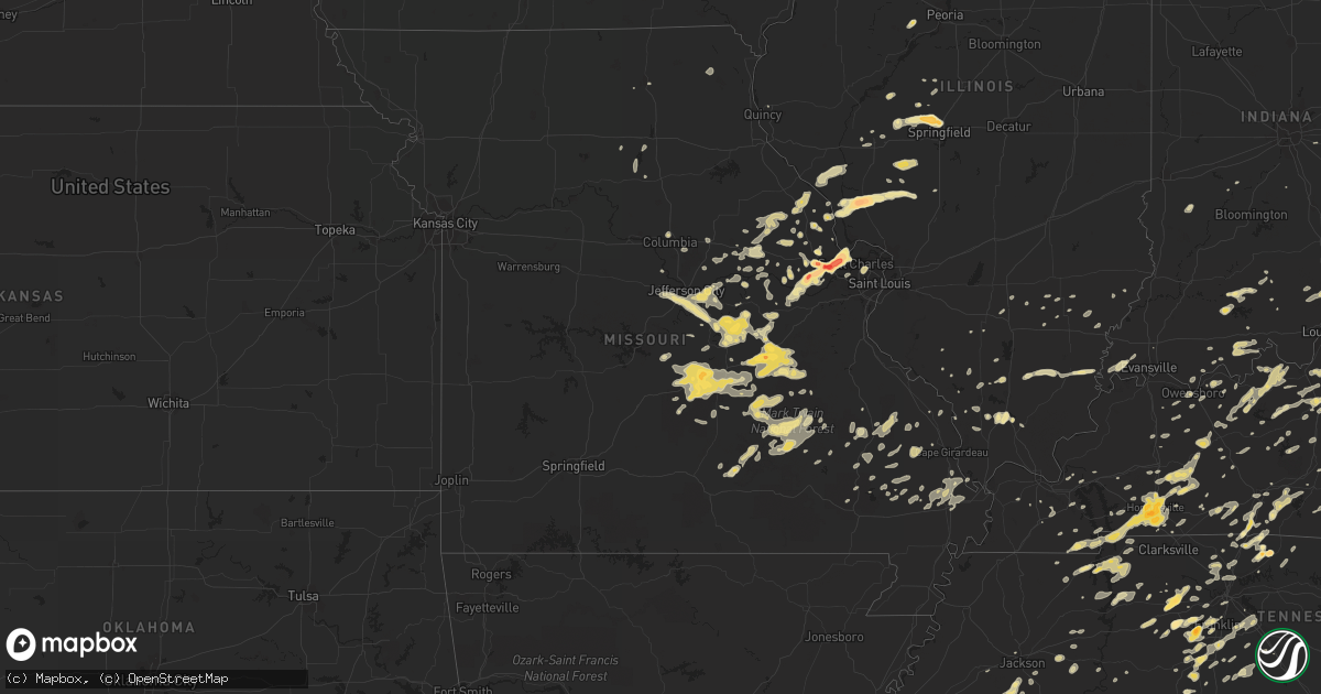
Hail Map in Missouri on March 15, 2012
Get this storm
March 15 map
$229
one time, instant access
Download today. No call, no setup
Keep the $229
Bought the map and want the full workflow? Apply the entire $229 to a subscription within 7 days. None of it is wasted.
Every map, not just this one
This buys you this map. Subscription and you get every map we run, in the markets you choose from a few cities to whole states to nationwide. Plus real-time alerts the moment a storm fires.
Contact data
Name, contact info, occupancy, even credit band for addresses in the footprint. You go from where it hit to who to call.
Become the source they trust
Unlimited branding weather history reports on demand. You already have the documented answer ready for the property owner, and you are the one who showed up with it.
Property data and RoofTrace estimates
Pull up any address you have got, its value and the exact code rules for that jurisdiction, straight from One Click Code. Then RoofTrace estimates the squares, pitch, and roof value, priced the way you price.
Storm reports in Missouri
Missouri
| Date | Description |
|---|---|
| 03/15/20126:43 PM CDT | Dime to quarter size hail. |
| 03/15/20126:05 PM CDT | A local report indicates 1.00 inch wind near NEWBURG |
| 03/15/20125:35 PM CDT | A local report indicates 1.00 inch wind near NEWBURG |
| 03/15/20125:25 PM CDT | A local report indicates 1.00 inch wind near JEROME |
| 03/15/20125:23 PM CDT | Pea to quarter size hail on i-70 west of hwy 19 |
| 03/15/20125:10 PM CDT | A local report indicates 1.00 inch wind near JEROME |
| 03/15/20125:05 PM CDT | A local report indicates 1.00 inch wind near 2 S CROCKER |
| 03/15/20124:59 PM CDT | Penny size hail with a few quarters mixed in. |
| 03/15/20124:49 PM CDT | At i-70 and hwy 79. Hail ranged from quarter size to ping pong ball size. |
| 03/15/20124:45 PM CDT | A local report indicates 1.25 inch wind near ST. PETERS |
| 03/15/20124:40 PM CDT | Hail reported over northern ofallon city. |
| 03/15/20124:38 PM CDT | Location approximate. Spotter is in st. Charles county south of old monroe and just north of i-70 and west of highway 79. |
| 03/15/20124:35 PM CDT | A local report indicates 1.00 inch wind near 5 S BELLE |
| 03/15/20124:34 PM CDT | Quarter size hail in berkeley. Report relayed by local media. |
| 03/15/20124:32 PM CDT | Retired nws employee reports golfball hail 3 miles south of ofallon |
| 03/15/20124:31 PM CDT | I-70 and tr hughs blvd. Quarter size hail covering the ground. |
| 03/15/20124:28 PM CDT | A local report indicates 1.00 inch wind near O'FALLON |
| 03/15/20124:27 PM CDT | At i-70 and veterans memorial pkwy between bryan rd and hwy k |
| 03/15/20124:25 PM CDT | A local report indicates 1.75 inch wind near DARDENNE PRAIRIE |
| 03/15/20124:25 PM CDT | A local report indicates 2.00 inch wind near 3 SSW O'FALLON |
| 03/15/20124:24 PM CDT | At feise and bryan rd |
| 03/15/20124:24 PM CDT | A local report indicates 1.50 inch wind near DARDENNE PRAIRIE |
| 03/15/20124:24 PM CDT | A local report indicates 1.75 inch wind near 2 SW O'FALLON |
| 03/15/20124:18 PM CDT | Storm chaser reports several hailstones of baseball size at winghaven blvd and i-64 |
| 03/15/20124:18 PM CDT | Hail just over 2 inches in diameter lasted about 3-4 minutes. |
| 03/15/20124:18 PM CDT | Nickel to quarter size hail at 270 and mcdonnell |
| 03/15/20124:16 PM CDT | A local report indicates 1.00 inch wind near DIXON |
| 03/15/20124:15 PM CDT | A local report indicates 1.75 inch wind near LAKE ST. LOUIS |
| 03/15/20124:15 PM CDT | Spotter is located south of n and 2 miles west of 61 |
| 03/15/20124:15 PM CDT | Windshield damage to car. Downed cedar limbs. Hail covered the ground. |
| 03/15/20124:13 PM CDT | Hail reported just north and west of lambert airport. |
| 03/15/20124:11 PM CDT | A local report indicates 1.00 inch wind near ST. ANN |
| 03/15/20124:11 PM CDT | Measured at hwy n and wyndgate ridge dr |
| 03/15/20124:10 PM CDT | Occuring at a part of the lambert international airport |
| 03/15/20124:10 PM CDT | A local report indicates 1.75 inch wind near NEW MELLE |
| 03/15/20124:05 PM CDT | Siding and garage door damaged. Goflball to tennis ball size hail. |
| 03/15/20124:04 PM CDT | A local report indicates 1.75 inch wind near NEW MELLE |
| 03/15/20124:02 PM CDT | A local report indicates 1.25 inch wind near NEW MELLE |
| 03/15/20123:55 PM CDT | Public reported quarter sized hail up to golf ball sized hail. |
| 03/15/20123:55 PM CDT | A local report indicates 1.00 inch wind near IBERIA |
| 03/15/20123:50 PM CDT | Nickel to quarter sized hail |
| 03/15/20123:50 PM CDT | Emergency manager reported power lines down...15 homes without power for aproximately three hours. |
| 03/15/20123:50 PM CDT | A local report indicates 1.00 inch wind near 6 NE MARTHASVILLE |
| 03/15/20123:40 PM CDT | A local report indicates 1.50 inch wind near FORT LEONARD WOOD |
| 03/15/20123:25 PM CDT | A local report indicates 1.50 inch wind near BELLE |
| 03/15/20122:23 PM CDT | A local report indicates 1.00 inch wind near 5 W CUBA |
| 03/15/20121:32 AM CDT | Nickel to quarter sized hail |
| 03/15/201212:46 AM CDT | Measured on the north side of columbia |
| 03/15/201212:41 AM CDT | Measured at the sheriffs office near i-70 |
| 03/14/20129:57 PM CDT | A local report indicates 1.00 inch wind near 1 S JEFFERSON CITY |
| 03/14/20129:47 PM CDT | A local report indicates 1.25 inch wind near 10 E JEFFERSON CITY |
| 03/14/20129:45 PM CDT | A local report indicates 1.00 inch wind near 2 S JEFFERSON CITY |
| 03/14/20129:35 PM CDT | A local report indicates 1.75 inch wind near 3 SSE CUBA |
| 03/14/20129:28 PM CDT | Hail size ranged from nickle to quarter. |
| 03/14/20129:15 PM CDT | A local report indicates 1.00 inch wind near JEFFERSON CITY |
| 03/14/20128:53 PM CDT | Relayed by ktjj radio |
All States Impacted by Hail Map on March 15, 2012
Cities Impacted by Hail Map on March 15, 2012
- Nebo, IL
- Pearl, IL
- Pittsfield, IL
- Pleasant Hill, IL
- Caro, MI
- Cobden, IL
- Greenfield, IL
- Chesterfield, IL
- Hettick, IL
- Carlinville, IL
- Talking Rock, GA
- Arcadia, MO
- Fredericktown, MO
- Pembroke, KY
- Oak Grove, KY
- Cadiz, KY
- Herndon, KY
- Gracey, KY
- Hopkinsville, KY
- Winfield, MO
- Decatur, TN
- Cloverport, KY
- Hawesville, KY
- Shepherdsville, KY
- Lebanon Junction, KY
- Tiplersville, MS
- Walnut, MS
- Barbourville, KY
- Cannon, KY
- Gray, KY
- Green Road, KY
- Heidrick, KY
- Girdler, KY
- Franklin, TN
- Spring Hill, TN
- Thompsons Station, TN
- College Grove, TN
- Louisville, KY
- Wilmington, OH
- Jamestown, OH
- Bonnots Mill, MO
- Marble Hill, GA
- Jasper, GA
- Foley, MO
- Elsberry, MO
- Ubly, MI
- Cass City, MI
- Deckerville, MI
- Snover, MI
- Leopold, MO
- Marble Hill, MO
- Burfordville, MO
- Whitewater, MO
- Grandview, IN
- Winchester, KY
- Eastview, KY
- Hudson, KY
- Big Clifty, KY
- Maineville, OH
- South Lebanon, OH
- Kings Mills, OH
- Morrow, OH
- Stollings, WV
- Holden, WV
- Chapmanville, WV
- Freeburn, KY
- Kermit, WV
- Wharncliffe, WV
- Henlawson, WV
- Matewan, WV
- Majestic, KY
- McCarr, KY
- Omar, WV
- Pecks Mill, WV
- Sarah Ann, WV
- Dingess, WV
- Gilbert, WV
- Harts, WV
- Williamson, WV
- Phelps, KY
- Delbarton, WV
- Logan, WV
- Switzer, WV
- Lenore, WV
- Lyburn, WV
- Yolyn, WV
- Breeden, WV
- Potosi, MO
- Mars Hill, NC
- Portland, TN
- Lamar, AR
- Springville, TN
- Paris, TN
- Buchanan, TN
- Chillicothe, OH
- Williamsport, OH
- Fayetteville, TN
- Florence, KY
- Union, KY
- Boston, KY
- Coxs Creek, KY
- Bardstown, KY
- Bloomfield, KY
- Salyersville, KY
- Bloomfield, MO
- Puxico, MO
- Campton, KY
- Crittenden, KY
- Dry Ridge, KY
- Saint Charles, VA
- Keokee, VA
- Dryden, VA
- Pennington Gap, VA
- Nashville, TN
- Middleton, TN
- Mayfield, KY
- Springfield, KY
- New Haven, KY
- Loretto, KY
- New Richmond, OH
- Bethel, OH
- Moscow, OH
- Silver Creek, GA
- Cedartown, GA
- Versailles, KY
- Bronson, MI
- West Hamlin, WV
- Branchland, WV
- Salt Rock, WV
- Hamlin, WV
- Foristell, MO
- Leasburg, MO
- Cuba, MO
- Bethpage, TN
- Burns, TN
- Dickson, TN
- White Bluff, TN
- Center, KY
- Greensburg, KY
- Edmonton, KY
- Cincinnati, OH
- New Florence, MO
- Carrollton, IL
- Kane, IL
- Eminence, MO
- Salem, MO
- Belvidere, TN
- McArthur, OH
- Hodges, AL
- Phil Campbell, AL
- Russellville, AL
- Hackleburg, AL
- Spruce Pine, AL
- Rockbridge, IL
- Eldred, IL
- Milan, MI
- Saline, MI
- Columbia, TN
- Fort Knox, KY
- West Point, KY
- Knoxville, TN
- Booneville, KY
- Bertrand, MO
- Charleston, MO
- Sikeston, MO
- Sneedville, TN
- Gallatin, TN
- Wellston, OH
- Jackson, OH
- Paoli, IN
- Maceo, KY
- Fairgrove, MI
- Akron, MI
- Belle, MO
- Jefferson City, MO
- Brownsville, TN
- Sunman, IN
- Huntland, TN
- Capac, MI
- Stewart, TN
- Big Sandy, TN
- Tennessee Ridge, TN
- Erin, TN
- Cumberland City, TN
- Dover, TN
- Hueysville, KY
- Leburn, KY
- Jackson, KY
- Garrett, KY
- Pleasant Plains, IL
- Springfield, IL
- Cantrall, IL
- Athens, IL
- Sherman, IL
- Petersburg, IL
- Tallula, IL
- Monteagle, TN
- Magnolia, KY
- Warsaw, KY
- Vevay, IN
- Winfield, WV
- Scott Depot, WV
- Hurricane, WV
- Clio, MI
- Imlay City, MI
- Millington, MI
- Birch Run, MI
- Attica, MI
- Columbiaville, MI
- Vassar, MI
- Lapeer, MI
- Otisville, MI
- Otter Lake, MI
- Hawk Point, MO
- Marshall, MI
- Cumming, GA
- Arrington, TN
- Waynesville, MO
- Palms, MI
- McGee, MO
- Danville, AL
- Paris, KY
- Hodgenville, KY
- Buffalo, KY
- Mount Sherman, KY
- Linden, TN
- Medon, TN
- Toone, TN
- Jackson, TN
- Dubois, IN
- Celestine, IN
- Warrenton, MO
- Marthasville, MO
- Simpsonville, KY
- Shelbyville, KY
- Fisherville, KY
- Nicholasville, KY
- Richmond, KY
- Lexington, KY
- Lancaster, KY
- Harbor Beach, MI
- Port Hope, MI
- Lawrenceburg, KY
- Harrodsburg, KY
- Willisburg, KY
- Salvisa, KY
- Hermann, MO
- Bean Station, TN
- Ray, OH
- Gordon, KY
- Cornettsville, KY
- Delphia, KY
- Viper, KY
- Slemp, KY
- Yeaddiss, KY
- Smilax, KY
- Bon Aqua, TN
- Lyles, TN
- Greenville, KY
- Dillsboro, IN
- Cross Plains, IN
- Versailles, IN
- Anna, OH
- Sidney, OH
- Fort Loramie, OH
- De Mossville, KY
- Waynesfield, OH
- Fulton, MO
- Columbia, MO
- Goodlettsville, TN
- Greenbrier, TN
- Whites Creek, TN
- Springfield, TN
- Ashland City, TN
- Joelton, TN
- Bridgeton, MO
- Saint Ann, MO
- Elizabethtown, KY
- Bourbon, MO
- New Liberty, KY
- Lockport, KY
- Sanders, KY
- Owenton, KY
- Campbellsburg, KY
- Pleasureville, KY
- Sparta, KY
- Bethlehem, KY
- Worthville, KY
- Clay City, IN
- Sharpsburg, KY
- Annapolis, MO
- Chamois, MO
- Morrison, MO
- Stanton, KY
- Ravenna, KY
- Clay City, KY
- Bainbridge, OH
- Edgar Springs, MO
- Licking, MO
- Beulah, MO
- Wheatfield, IN
- La Crosse, IN
- San Pierre, IN
- Kouts, IN
- North Judson, IN
- Winamac, IN
- Chicora, PA
- Lafayette, TN
- Westmoreland, TN
- Primm Springs, TN
- Santa Fe, TN
- Berry, KY
- Cynthiana, KY
- Hamilton, IN
- Norris City, IL
- New Haven, IL
- Carmi, IL
- Ann Arbor, MI
- Dexter, MI
- Ypsilanti, MI
- Pinckney, MI
- Chelsea, MI
- Whitmore Lake, MI
- Gregory, MI
- Pocahontas, TN
- Rosebud, MO
- Elkton, MI
- Pigeon, MI
- Owendale, MI
- Bledsoe, KY
- Mozelle, KY
- Warbranch, KY
- Helton, KY
- Ghent, KY
- Summersville, MO
- Waverly, TN
- McEwen, TN
- Cottontown, TN
- Goreville, IL
- Georgetown, KY
- Midway, KY
- Stamping Ground, KY
- Troy, MO
- Truxton, MO
- Silex, MO
- Marquand, MO
- Patton, MO
- Washington, MO
- Augusta, MO
- Golden Eagle, IL
- Defiance, MO
- Wentzville, MO
- Lake Saint Louis, MO
- O'Fallon, MO
- Saint Peters, MO
- Saint Charles, MO
- Rhineland, MO
- Finchville, KY
- Putney, KY
- Baxter, KY
- Evarts, KY
- Eckerty, IN
- English, IN
- Howell, MI
- Pulaski, TN
- Fieldon, IL
- Hardin, IL
- Unionville, MI
- Gagetown, MI
- Whiteville, TN
- Bolivar, TN
- Hickory Valley, TN
- Jerome, MO
- Newburg, MO
- Dixon, MO
- Riga, MI
- Blissfield, MI
- Ottawa Lake, MI
- Bluffton, OH
- Lynnville, TN
- Ethridge, TN
- Mayville, MI
- Southside, WV
- Summertown, TN
- Petersburg, MI
- Dundee, MI
- Britton, MI
- Monroe, MI
- La Salle, MI
- Ida, MI
- Temperance, MI
- Deerfield, MI
- Tecumseh, MI
- Maybee, MI
- Dallas, GA
- Deputy, IN
- Evansville, IN
- Durand, MI
- Byron, MI
- Gaines, MI
- Caryville, TN
- Jacksboro, TN
- Ozark, IL
- Franklin, KY
- Wellsville, MO
- Bellflower, MO
- Middletown, MO
- Bowling Green, MO
- Montgomery City, MO
- Wauseon, OH
- Leslie, MO
- Gerald, MO
- Mount Vernon, IN
- Ricetown, KY
- Wapakoneta, OH
- Eastpointe, MI
- Roseville, MI
- Warren, MI
- Essex, MO
- Rolla, MO
- Saint Robert, MO
- Duke, MO
- Devils Elbow, MO
- Crocker, MO
- Saint James, MO
- Fort Leonard Wood, MO
- Ooltewah, TN
- Glasgow, KY
- Knob Lick, KY
- Westphalia, MO
- Freeburg, MO
- Lohman, MO
- Koeltztown, MO
- Knox, IN
- Bonnieville, KY
- Centerville, TN
- Springport, MI
- Chandlerville, IL
- Almont, MI
- Dryden, MI
- Rineyville, KY
- Cecilia, KY
- Moscow Mills, MO
- Alpha, KY
- Albany, KY
- Bunker, MO
- Mulberry, TN
- Kelso, TN
- Nolensville, TN
- Smyrna, TN
- Trivoli, IL
- Glasford, IL
- Canton, IL
- Falls Of Rough, KY
- Harned, KY
- Dundee, KY
- Union Star, KY
- Guston, KY
- Fordsville, KY
- Rhodelia, KY
- Ekron, KY
- Hartford, KY
- Webster, KY
- Hardinsburg, KY
- Brandenburg, KY
- Payneville, KY
- Irvington, KY
- Olaton, KY
- Bay City, MI
- Essexville, MI
- Kawkawlin, MI
- Big Rock, TN
- Williamsville, MO
- Indian Mound, TN
- Counce, TN
- Michie, TN
- Hyden, KY
- Reese, MI
- Leicester, NC
- Brevard, NC
- Pisgah Forest, NC
- California, KY
- Butler, KY
- Columbus Grove, OH
- Vaughnsville, OH
- West Sunbury, PA
- Karns City, PA
- Petrolia, PA
- Wadesville, IN
- Pikeville, KY
- Raccoon, KY
- Mayslick, KY
- Hazel Green, KY
- Frenchburg, KY
- Wellington, KY
- Fairview, TN
- Minor Hill, TN
- Lester, AL
- Marion, OH
- Hindman, KY
- Pippa Passes, KY
- Garner, KY
- Put In Bay, OH
- Irvine, KY
- McKee, KY
- Berea, KY
- Waynesville, OH
- Oregonia, OH
- Lebanon, OH
- Clarksville, OH
- Jonesboro, IL
- Anna, IL
- Metamora, MI
- Ashland, IL
- Fairfield, IL
- Ava, IL
- Vine Grove, KY
- Georgetown, OH
- Augusta, KY
- Brooksville, KY
- Ezel, KY
- Keenes, IL
- Hillsboro, AL
- Boss, MO
- Cherryville, MO
- Cub Run, KY
- Decatur, AL
- Tanner, AL
- Athens, AL
- Makanda, IL
- Marion, IL
- Carbondale, IL
- Hazelwood, MO
- Maryland Heights, MO
- Saint Louis, MO
- Scottsville, KY
- Nunnelly, TN
- Owingsville, KY
- Henryville, IN
- Corinth, KY
- Williamstown, KY
- Williamsport, TN
- Underwood, IN
- Scottsburg, IN
- Bevinsville, KY
- Topmost, KY
- Kite, KY
- Chagrin Falls, OH
- Burton, OH
- De Soto, IL
- Jenera, OH
- Franklin, IL
- Modesto, IL
- Waverly, IL
- Virden, IL
- Farwell, MI
- Clare, MI
- La Vergne, TN
- Culleoka, TN
- Mount Pleasant, TN
- Murfreesboro, TN
- Perryville, MO
- Yawkey, WV
- Sod, WV
- Alkol, WV
- Griffithsville, WV
- Saint Albans, WV
- Nickelsville, VA
- Meta, MO
- Quincy, MI
- North Vernon, IN
- Steelville, MO
- North Branch, MI
- Silverwood, MI
- Murray, KY
- Kirksey, KY
- Lexington, TN
- Huron, TN
- New Concord, KY
- Lesterville, MO
- Leoma, TN
- Owensville, MO
- Manchester, MI
- Willis, MI
- Belleville, MI
- Grass Lake, MI
- Van Buren, OH
- McComb, OH
- Haleyville, AL
- Falmouth, KY
- Black, MO
- Loose Creek, MO
- Cleveland, VA
- Goodells, MI
- Apison, TN
- Cerulean, KY
- Clifford, MI
- Mount Washington, KY
- Big Laurel, KY
- Carbon Hill, AL
- Eldridge, AL
- Jeromesville, OH
- Wooster, OH
- Beaverton, MI
- South Pittsburg, TN
- Otisco, IN
- Nabb, IN
- Hanover, IN
- Pekin, IN
- Milton, KY
- Lexington, IN
- Marysville, IN
- Borden, IN
- Burkesville, KY
- Byrdstown, TN
- Allons, TN
- Monroe, TN
- Livingston, TN
- Celina, TN
- Monticello, KY
- Jamestown, KY
- Cecil, OH
- Paulding, OH
- Milltown, IN
- Hardinsburg, IN
- New Tazewell, TN
- Raywick, KY
- Lebanon, KY
- Simpson, IL
- Minden City, MI
- Palmyra, IL
- Herrin, IL
- West Frankfort, IL
- Mount Hope, AL
- Martin, KY
- Prestonsburg, KY
- David, KY
- Blue River, KY
- Campbellsville, KY
- Toledo, OH
- Francesville, IN
- Belgrade, MO
- Albion, PA
- Conneaut, OH
- Ellington, MO
- Addison, AL
- Vinemont, AL
- Falkville, AL
- Crofton, KY
- White Plains, KY
- Huntsville, AL
- Madison, AL
- Fostoria, OH
- Risingsun, OH
- Alexander, IL
- Cookeville, TN
- Allenton, MI
- Huntsville, MO
- Orleans, IN
- Wilmington, IL
- Bland, MO
- Philpot, KY
- Lewisport, KY
- Mason, OH
- Pleasant Plain, OH
- Blanchester, OH
- Trenton, OH
- Hamilton, OH
- Somerville, OH
- Goshen, OH
- Batavia, OH
- Burr Oak, MI
- Twelve Mile, IN
- Macy, IN
- Rochester, IN
- Bumpus Mills, TN
- Hazel, KY
- Vienna, MO
- Lake, MI
- Sears, MI
- Cornersville, TN
- Centerville, MO
- Freeman Spur, IL
- Vichy, MO
- Oxford, MI
- Beattyville, KY
- Benton, MO
- New Haven, MO
- Sewanee, TN
- Hanson, KY
- Sacramento, KY
- Madisonville, KY
- Thousandsticks, KY
- Princeton, KY
- Charlestown, IN
- Russell Springs, KY
- Nancy, KY
- Pomona, IL
- Romulus, MI
- Salem, IN
- Germantown, KY
- Tell City, IN
- Clarkson, KY
- Mammoth Cave, KY
- Oxford, OH
- Bay Port, MI
- Henderson, WV
- Thompsonville, IL
- Broughton, IL
- Eldorado, IL
- Macedonia, IL
- Ranger, WV
- Harvest, AL
- Petersburg, TN
- Williamsburg, OH
- Mount Orab, OH
- Alvaton, KY
- Xenia, OH
- Fort Campbell, KY
- Marshall, NC
- Jacksonville, IL
- Big Stone Gap, VA
- Decaturville, TN
- Centertown, KY
- Beaver Dam, KY
- Central City, KY
- Rockport, KY
- Rudolph, OH
- Cygnet, OH
- Trinity, AL
- Moulton, AL
- Berger, MO
- Lawrenceburg, TN
- Unionville, TN
- Lewisburg, TN
- Shelbyville, TN
- Busy, KY
- La Belle, MO
- Rutledge, MO
- Wyaconda, MO
- Grassy Creek, NC
- Crumpler, NC
- Piney Creek, NC
- Glenallen, MO
- Zalma, MO
- Ona, WV
- Glenwood, WV
- Nashville, IL
- Liberty, IN
- Powell, TN
- Heiskell, TN
- Clinton, TN
- Frankfort, KY
- Radcliff, KY
- Fraziers Bottom, WV
- Red House, WV
- Spurlockville, WV
- Culloden, WV
- Sumerco, WV
- Milton, WV
- Tornado, WV
- Lesage, WV
- Eleanor, WV
- Franklin Furnace, OH
- Wheelersburg, OH
- Pedro, OH
- Eolia, MO
- Homer, MI
- Tekonsha, MI
- Coldwater, MI
- Menlo, GA
- Gaylesville, AL
- Lyerly, GA
- Summerville, GA
- Angola, IN
- Waco, KY
- Sedgewickville, MO
- Friedheim, MO
- Oak Ridge, MO
- Daisy, MO
- Waddy, KY
- Wise, VA
- Pound, VA
- Scott, OH
- Clarklake, MI
- Jackson, MI
- Owosso, MI
- Independence, VA
- Wayne City, IL
- Charlotte, TN
- Steedman, MO
- Wewahitchka, FL
- Bristol, FL
- Eastern, KY
- Langley, KY
- Oak Harbor, OH
- Port Clinton, OH
- Vest, KY
- Bulan, KY
- Milford, OH
- West Chester, OH
- Loveland, OH
- Miamiville, OH
- Camp Dennison, OH
- Perrysburg, OH
- Walbridge, OH
- Uniopolis, OH
- Webberville, MI
- Fowlerville, MI
- Burlington, KY
- Petersburg, KY
- McHenry, KY
- Salisbury, MO
- Marceline, MO
- New Cambria, MO
- Clarksville, MO
- Krypton, KY
- Lamar, IN
- Evanston, IN
- Wright City, MO
- Townsend, TN
- Kiahsville, WV
- Elkton, KY
- Davisville, MO
- Gays Creek, KY
- Oneida, KY
- Chavies, KY
- Buckhorn, KY
- Rockmart, GA
- Clayhole, KY
- Bad Axe, MI
- Green Mountain, NC
- Scotts Hill, TN
- Reagan, TN
- Holland, OH
- Maumee, OH
- Lambertville, MI
- Palmyra, MI
- Delta, OH
- Monclova, OH
- Sylvania, OH
- Jasper, MI
- Adrian, MI
- Lyons, OH
- Erie, MI
- Metamora, OH
- Swanton, OH
- Carleton, MI
- Oregon, OH
- Sand Creek, MI
- Berkey, OH
- Madison, TN
- Sullivan, MO
- Ruth, MI
- Ada, OH
- Owensboro, KY
- La Follette, TN
- Lewisburg, KY
- Oak Hill, OH
- Saint Croix, IN
- Branchville, IN
- Bristow, IN
- Freedom, PA
- Trafalgar, IN
- Hickory, KY
- Melber, KY
- Jonesburg, MO
- Union City, MI
- Grand Tower, IL
- Dayton, KY
- Newport, KY
- Ft Mitchell, KY
- Covington, KY
- Fort Thomas, KY
- Bellevue, KY
- Auburn Hills, MI
- Pontiac, MI
- Bloomfield Hills, MI
- Sterling Heights, MI
- Utica, MI
- Davison, MI
- Iberia, MO
- Savannah, TN
- Shiloh, TN
- Ramer, TN
- Guys, TN
- Selmer, TN
- Vulcan, MO
- Webbville, KY
- Bethlehem, IN
- Pendleton, KY
- Westport, KY
- Bedford, KY
- La Grange, KY
- New Washington, IN
- Mount Sterling, KY
- Custar, OH
- Beech Creek, KY
- Drakesboro, KY
- Belton, KY
- Leopold, IN
- Cook Sta, MO
- Richland, MO
- Lakeside Marblehead, OH
- Grand Blanc, MI
- Fostoria, MI
- Goodrich, MI
- Eva, TN
- Camden, TN
- Woodburn, KY
- Bowling Green, KY
- Linwood, MI
- Allen, KY
- Bellevue, OH
- New Palestine, IN
- Marathon, TX
- Cleveland, OH
- Gates Mills, OH
- Killen, AL
- Rogersville, AL
- Anderson, AL
- Muscle Shoals, AL
- Town Creek, AL
- West Baden Springs, IN
- French Lick, IN
- Seco, KY
- Millstone, KY
- McRoberts, KY
- Thornton, KY
- Neon, KY
- Whitesburg, KY
- Du Bois, IL
- Newcomerstown, OH
- New Bloomfield, MO
- Cisne, IL
- Marion, NC
- Spruce Pine, NC
- Florence, AL
- Glendale, KY
- Aragon, GA
- Scott City, MO
- Bell City, MO
- Oran, MO
- Vanduser, MO
- Calhoun, KY
- Bevier, MO
- Macon, MO
- White House, TN
- Morgantown, KY
- Archbold, OH
- Napoleon, OH
- Glencoe, KY
- Alexandria, KY
- Leipsic, OH
- Ottawa, OH
- Science Hill, KY
- Jasper, IN
- Summer Shade, KY
- Henderson, TN
- Nortonville, KY
- Kirksville, MO
- Cross Plains, TN
- Orlinda, TN
- Pittsford, MI
- Addison, MI
- Hudson, MI
- Ortonville, MI
- Holly, MI
- Cave City, KY
- Horse Cave, KY
- Whick, KY
- Ceresco, MI
- Sadieville, KY
- Stopover, KY
- Phyllis, KY
- Kimper, KY
- Hurley, VA
- Gosport, IN
- Utica, KY
- Thurman, OH
- Vinton, OH
- Farmington, MO
- Hiltons, VA
- Pinson, TN
- Beech Bluff, TN
- Battle Creek, MI
- East Leroy, MI
- Manchester, KY
- Batchtown, IL
- Jackson, MO
- Olivehill, TN
- Clifton, TN
- Gate City, VA
- Republic, OH
- Tiffin, OH
- Linn, MO
- Annville, KY
- Kell, IL
- Hazard, KY
- Gurley, AL
- Troy, IN
- Leitchfield, KY
- Garfield, KY
- Wappapello, MO
- Hartsville, TN
- Taylorsville, KY
- Regina, KY
- Almo, KY
- Dexter, KY
- Beaver, KY
- Mousie, KY
- Wayland, KY
- McDowell, KY
- Raven, KY
- Teaberry, KY
- Gunlock, KY
- Ary, KY
- Lackey, KY
- Lost Creek, KY
- Grethel, KY
- Hi Hat, KY
- Emmalena, KY
- Fenton, MI
- Russellville, KY
- Auburn, KY
- Bentley, MI
- Rhodes, MI
- Greenville, MO
- Clubb, MO
- Bagdad, KY
- Banner, KY
- Dawson, AL
- Catlettsburg, KY
- Vincent, KY
- Saint Clair Shores, MI
- Redford, MO
- Bixby, MO
- Belleview, MO
- Chesterland, OH
- Willoughby, OH
- Advance, MO
- Sturdivant, MO
- Defiance, OH
- Lynchburg, OH
- Benton, KY
- Waverly, OH
- Dryden, TX
- Genoa, OH
- Curtice, OH
- Millbury, OH
- Ivel, KY
- Printer, KY
- Tram, KY
- Old Monroe, MO
- Toney, AL
- Smiths Grove, KY
- Brentwood, TN
- Crestwood, KY
- Mount Vernon, KY
- Livingston, KY
- Saltville, VA
- Meadowview, VA
- Winchester, IL
- Dawsonville, GA
- Bidwell, OH
- Dix, IL
- Mount Vernon, IL
- Goodspring, TN
- Hanna City, IL
- Albion, IL
- Grayville, IL
- London, AR
- Tracy City, TN
- Tazewell, TN
- Decherd, TN
- Pelham, TN
- Lexington, AL
- Loretto, TN
- Mount Morris, MI
- Martin, OH
- Rocky Ridge, OH
- Graytown, OH
- Elmore, OH
- Auburn, MI
- Midland, MI
- Corinth, MS
- Oakland, KY
- Jamestown, MO
- Centertown, MO
- Russellville, MO
- Star City, IN
- Manitou, KY
- Kewanna, IN
- Sumner, IL
- Detroit, MI
- Center Line, MI
- Tellico Plains, TN
- Trenton, KY
- Guthrie, KY
- Beaver, OH
- Hillsboro, KY
- Wayne, OH
- Bradner, OH
- Shelbiana, KY
- Madison, IN
- Sesser, IL
- Mulkeytown, IL
- Benton, IL
- Taylor, MI
- Smithland, KY
- Grand Rivers, KY
- Lenox, MO
- Macomb, MI
- Yukon, MO
- Cleves, OH
- Clinton, MI
- Butler, PA
- Renfrew, PA
- Christiana, TN
- Glenwood, IN
- Connersville, IN
- Middletown, OH
- Puryear, TN
- Cottage Grove, TN
- Bell Buckle, TN
- Shoals, IN
- Adolphus, KY
- Mansfield, TN
- Courtland, AL
- Du Quoin, IL
- Vergennes, IL
- Spencer, IN
- Rockfield, KY
- Boone, NC
- Banner Elk, NC
- Hamburg, IL
- Annada, MO
- Campbell Hill, IL
- Percy, IL
- Brumley, MO
- Mitchell, IN
- Golden Gate, IL
- Ellery, IL
- Lucerne, IN
- Kingdom City, MO
- Auxvasse, MO
- Stryker, OH
- Corning, AR
- Newbury, OH
- Novelty, OH
- Madisonville, TN
- New Castle, KY
- Eminence, KY
- High Hill, MO
- West College Corner, IN
- College Corner, OH
- Camden, OH
- Miamisburg, OH
- Ironton, MO
- Chapel Hill, TN
- Speedwell, TN
- Whitesville, KY
- Boaz, KY
- Clarksburg, OH
- Viburnum, MO
- Evart, MI
- Coleman, MI
- Brownwood, MO
- Saint Francis, KY
- Big Creek, KY
- Jonesville, KY
- Kingston Springs, TN
- Mason City, IL
- Gorham, IL
- Murphysboro, IL
- Pegram, TN
- Hamtramck, MI
- Wildersville, TN
- Clifton Hill, MO
- Eddyville, KY
- Rushville, IN
- Standish, MI
- Pinconning, MI
- Pikeville, TN
- Spring City, TN
- Elkmont, AL
- Lima, OH
- Filion, MI
- New Holland, OH
- Wooton, KY
- Mount Carmel, IL
- West Salem, IL
- Sturgis, MI
- Uniontown, MO
- Hilham, TN
- North Middletown, KY
- Carlisle, KY
- Pine Ridge, KY
- Battletown, KY
- Cannelton, IN
- Tompkinsville, KY
- Williamsburg, MO
- Monterey, IN
- Morenci, MI
- New Boston, MI
- Dansville, MI
- Clayton, MI
- Harbor View, OH
- Waterville, OH
- Canton, MI
- Stockbridge, MI
- Rockvale, TN
- Eagleville, TN
- Mount Sterling, MO
- Quincy, IL
- Westport, TN
- Santa Claus, IN
- Dale, IN
- Belfry, KY
- South Williamson, KY
- Forest Hills, KY
- Pemberville, OH
- Luckey, OH
- Jasonville, IN
- Perry Park, KY
- Moores Hill, IN
- Clyde, OH
- Bonnyman, KY
- Mistletoe, KY
- Sizerock, KY
- Eaton, OH
- West Alexandria, OH
- Sparta, IL
- Upper Sandusky, OH
- Frankewing, TN
- Mount Eden, KY
- Florence, IN
- Cumberland Furnace, TN
- Beaufort, MO
- Harrison, OH
- Hebron, KY
- North Bend, OH
- Bowling Green, OH
- Rydal, GA
- Adairsville, GA
- Commiskey, IN
- Greenview, IL
- Bardwell, KY
- Cunningham, KY
- Fairfield, OH
- Columbia, KY
- Creola, OH
- Laquey, MO
- Bruin, PA
- Parker, PA
- Island, KY
- Rumsey, KY
- Isle Saint George, OH
- Peebles, OH
- Argyle, MO
- Salt Lick, KY
- Mansfield, OH
- Onondaga, MI
- Dunlow, WV
- Wilsondale, WV
- Hartselle, AL
- Albion, MI
- Parma, MI
- Bennington, IN
- Rising Sun, IN
- Patriot, IN
- Rockport, IN
- Mentor, OH
- Fort Payne, AL
- Gallipolis, OH
- Gallipolis Ferry, WV
- Bluford, IL
- Texico, IL
- Port William, OH
- Cannel City, KY
- West Liberty, KY
- Silva, MO
- Caneyville, KY
- Hornsby, TN
- Drift, KY
- Harold, KY
- Bear Branch, KY
- Rowdy, KY
- Dema, KY
- Dana, KY
- Dwale, KY
- Crab Orchard, KY
- Helena, OH
- Fremont, OH
- Frankfort, OH
- Tawas City, MI
- Somerville, TN
- Grand Junction, TN
- Ridgeville Corners, OH
- Brooklyn, MI
- Norvell, MI
- Johnsonville, IL
- Tyner, KY
- Sandgap, KY
- Litchfield, MI
- Pleasant Lake, IN
- Englewood, TN
- Bee, VA
- Davenport, VA
- Campbellsburg, IN
- Chapin, IL
- Buncombe, IL
- Circleville, OH
- Kuttawa, KY
- Peru, IN
- Denver, IN
- Miller City, IL
- Altenburg, MO
- Frohna, MO
- Hillview, IL
- Lindsey, OH
- Waggoner, IL
- McDonald, TN
- Omaha, IL
- Fedscreek, KY
- Steele, KY
- Flint, MI
- Genesee, MI
- Brownsville, KY
- Antioch, TN
- Prospect, KY
- Goshen, KY
- Lawrenceburg, IN
- Guilford, IN
- Aurora, IN
- Rensselaer, IN


