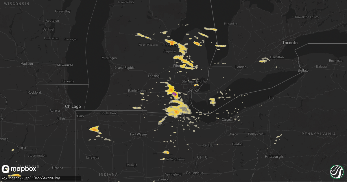
Hail Map on March 15, 2012
Get this storm
March 15 map
$229
one time, instant access
Download today. No call, no setup
Keep the $229
Bought the map and want the full workflow? Apply the entire $229 to a subscription within 7 days. None of it is wasted.
Every map, not just this one
This buys you this map. Subscription and you get every map we run, in the markets you choose from a few cities to whole states to nationwide. Plus real-time alerts the moment a storm fires.
Contact data
Name, contact info, occupancy, even credit band for addresses in the footprint. You go from where it hit to who to call.
Become the source they trust
Unlimited branding weather history reports on demand. You already have the documented answer ready for the property owner, and you are the one who showed up with it.
Property data and RoofTrace estimates
Pull up any address you have got, its value and the exact code rules for that jurisdiction, straight from One Click Code. Then RoofTrace estimates the squares, pitch, and roof value, priced the way you price.
States Impacted by Hail Map on March 15, 2012
Storm reports
Georgia
| Date | Description |
|---|---|
| 03/15/20126:30 PM CDT | Amateur radio relayed report of quarter sized hail in the shiflett road and pleasant hope road area of southeastern floyd county around 730 pm edt. |
| 03/15/20126:25 PM CDT | Floyd county emergency management relayed a public report of quarter sized hail in southeastern floyd county around 725 pm edt. |
| 03/15/20126:25 PM CDT | A local business north west of aragon reported pea sized hail increasing rapidly to quarter size. The rain was very heavy and the pea size hail accumulated for a few mi |
| 03/15/20125:55 PM CDT | Public reported quarter sized hail while driving on hwy 278 about 3 miles west of rockmart around 655 pm edt. |
| 03/14/201211:27 PM CDT | Golfball sized hail reported between 1227-1239am. |
| 03/14/20128:55 PM CDT | Bartow county 911 employee reported dime to quarter sized hail at their residence near the gordon-bartow county line. Noted hail covered lawn and car hoods. Radar estim |
Illinois
| Date | Description |
|---|---|
| 03/15/20125:54 PM CDT | Hail reported from pea to baseball size. |
| 03/15/20125:53 PM CDT | A local report indicates 1.75 inch wind near 2 E CARROLLTON |
| 03/15/20125:50 PM CDT | Relayed by local media |
| 03/15/20125:49 PM CDT | Hail size ranging between golf ball and tennis ball |
| 03/15/20125:48 PM CDT | A local report indicates 1.50 inch wind near CARROLLTON |
| 03/15/20125:47 PM CDT | A local report indicates 1.50 inch wind near CARROLLTON |
| 03/15/20125:45 PM CDT | A local report indicates 1.00 inch wind near FRANKLIN |
| 03/15/20125:40 PM CDT | A local report indicates 1.00 inch wind near WAVERLY |
| 03/15/20125:40 PM CDT | A local report indicates 1.75 inch wind near CARROLLTON |
| 03/14/201211:07 PM CDT | A local report indicates 1.00 inch wind near 10 SE NORRIS CITY |
| 03/14/201210:23 PM CDT | Possible quarter hail report from public |
| 03/14/201210:00 PM CDT | Possible quarter hail report from public |
| 03/14/201210:00 PM CDT | Public called local news to report possible half dollar sized hail. |
| 03/14/20128:25 PM CDT | A local report indicates 1.75 inch wind near 2 W CANTRALL |
| 03/14/20128:20 PM CDT | A local report indicates 1.00 inch wind near SHERMAN |
| 03/14/20128:15 PM CDT | A local report indicates 1.00 inch wind near 2 W SHERMAN |
| 03/14/20128:14 PM CDT | A local report indicates 1.00 inch wind near CANTRALL |
| 03/14/20128:06 PM CDT | A local report indicates 1.00 inch wind near 2 SW ATHENS |
| 03/14/20127:47 PM CDT | Swop report. |
Ohio
| Date | Description |
|---|---|
| 03/15/20126:19 PM CDT | A local report indicates 1.00 inch wind near 4 N TOLEDO |
| 03/15/20125:45 PM CDT | A local report indicates 1.00 inch wind near OXFORD |
| 03/15/20125:38 PM CDT | Time estimated by radar. |
| 03/15/20125:30 PM CDT | Time estimated by radar. |
| 03/15/20125:30 PM CDT | A local report indicates 1.00 inch wind near REILY |
| 03/15/20125:01 PM CDT | A local report indicates 1.00 inch wind near ANNA |
| 03/15/20124:34 PM CDT | A local report indicates 1.25 inch wind near MCCARTYVILLE |
| 03/15/20124:05 PM CDT | A local report indicates 1.75 inch wind near WAYNESFIELD |
| 03/15/20124:02 PM CDT | A local report indicates 1.00 inch wind near WAYNESFIELD |
| 03/15/20123:50 PM CDT | Photo submission. Time estimated from radar. |
| 03/15/20123:30 PM CDT | A local report indicates 1.00 inch wind near WAPAKONETA |
| 03/15/201210:33 AM CDT | A local report indicates 1.00 inch wind near CLARKSVILLE |
| 03/15/201210:28 AM CDT | Via broadcast media |
| 03/15/201210:00 AM CDT | A local report indicates 1.00 inch wind near WHITE OAK |
Indiana
| Date | Description |
|---|---|
| 03/15/20126:30 PM CDT | A local report indicates 1.00 inch wind near FULTON |
| 03/15/20125:26 PM CDT | A local report indicates 1.75 inch wind near NORTH JUDSON |
| 03/15/20125:15 PM CDT | A local report indicates 1.00 inch wind near CONNERSVILLE |
| 03/15/20124:47 PM CDT | Corrected time and location |
| 03/15/20124:44 PM CDT | A local report indicates 1.00 inch wind near STAR CITY |
| 03/15/20124:22 PM CDT | A local report indicates 1.00 inch wind near FRANCESVILLE |
| 03/15/20123:18 PM CDT | A local report indicates 1.00 inch wind near HENRYVILLE |
| 03/15/20122:44 PM CDT | A local report indicates 1.25 inch wind near 6 SSW FRENCH LICK |
| 03/15/20122:33 PM CDT | A local report indicates 1.50 inch wind near DUBOIS |
| 03/15/20122:20 PM CDT | A local report indicates 1.00 inch wind near FERDINAND |
| 03/15/20121:55 PM CDT | Additional report. Hail lasting for nearly 5 minutes. Wind gusts 40 mph associated with this storm. |
| 03/15/20121:47 PM CDT | Quarter size hail reported. |
| 03/15/20121:10 PM CDT | Quarter size hail reported. |
Kentucky
| Date | Description |
|---|---|
| 03/15/20126:56 PM CDT | A few trees down. |
| 03/15/20126:40 PM CDT | Minor roof damage and a power line down. |
| 03/15/20126:18 PM CDT | One tree down on hwy 790. |
| 03/15/20126:08 PM CDT | Trees down. Also some trees down in northwest jessamine county. |
| 03/15/20125:55 PM CDT | Tree on a house. |
| 03/15/20125:52 PM CDT | Minor roof damage and a power line down. |
| 03/15/20125:48 PM CDT | Tree down on battlefield road. |
| 03/15/20125:46 PM CDT | A local report indicates 1.00 inch wind near 5 NNW MOUNT STERLING |
| 03/15/20125:43 PM CDT | A local report indicates 1.00 inch wind near 1 W PEACH GROVE |
| 03/15/20125:37 PM CDT | A local report indicates 1.00 inch wind near 6 W ALBANY |
| 03/15/20125:01 PM CDT | On i-75 in southeast fayette. |
| 03/15/20124:53 PM CDT | A local report indicates 1.25 inch wind near RUSSELL SPRINGS |
| 03/15/20124:47 PM CDT | Corrected time and location |
| 03/15/20124:45 PM CDT | A local report indicates 60 MPH wind near 4 SW BRANDENBURG |
| 03/15/20124:42 PM CDT | Trees on power lines. |
| 03/15/20124:35 PM CDT | Tree down across squirrel tail hollow road. |
| 03/15/20124:35 PM CDT | A local report indicates 1.00 inch wind near 4 S WARSAW |
| 03/15/20124:35 PM CDT | Tree down across squirrel tail hollow road. |
| 03/15/20124:08 PM CDT | A local report indicates 1.75 inch wind near 5 E ALBANY |
| 03/15/20124:05 PM CDT | A local report indicates 1.00 inch wind near NE HISEL |
| 03/15/20124:05 PM CDT | A local report indicates 1.75 inch wind near MIDWAY |
| 03/15/20124:03 PM CDT | Near beaver lake. |
| 03/15/20123:54 PM CDT | Several reports of quarter size hail. |
| 03/15/20123:53 PM CDT | Report via twitter. |
| 03/15/20123:48 PM CDT | Tree down on james nancey lane. |
| 03/15/20123:48 PM CDT | A local report indicates 1.25 inch wind near FRANKLIN |
| 03/15/20123:44 PM CDT | A local report indicates 1.00 inch wind near WILLISBURG |
| 03/15/20123:40 PM CDT | Nickle to quarter size hail with gusts to near 50 mph. Time estimated based on radar. |
| 03/15/20123:38 PM CDT | A local report indicates 1.00 inch wind near 2 N SCOTTSVILLE |
| 03/15/20123:30 PM CDT | Golf ball sized hail on granny fork off hwy 699. |
| 03/15/20123:27 PM CDT | A local report indicates 1.00 inch wind near 1 S FALMOUTH |
| 03/15/20123:20 PM CDT | Beulah church road. |
| 03/15/20123:15 PM CDT | Golf ball hail destroyed pickup. |
| 03/15/20123:12 PM CDT | A local report indicates 1.00 inch wind near DRYHILL |
| 03/15/20123:07 PM CDT | Quarter size hail on hell for certain road. |
| 03/15/20123:04 PM CDT | The hail ranged from dime size to half dollar size |
| 03/15/20122:53 PM CDT | Quarter size hail reported west of town. |
| 03/15/20122:35 PM CDT | Quarter size hail reported. |
| 03/15/20122:35 PM CDT | A local report indicates 1.50 inch wind near 9 SE HODGENVILLE |
| 03/15/20122:25 PM CDT | A local report indicates 1.00 inch wind near LAMONT |
| 03/15/20122:20 PM CDT | Several reports of quarter size hail southeast of town. |
| 03/15/20122:20 PM CDT | A local report indicates 1.00 inch wind near ELIZABETHTOWN |
| 03/15/20122:01 PM CDT | A local report indicates 1.00 inch wind near 5 ESE TEMPLE HILL |
| 03/15/20121:45 PM CDT | Quarter sized hail was reported by a trained spotter. |
| 03/15/20121:42 PM CDT | A local report indicates 1.00 inch wind near PIPPA PASSES |
| 03/15/20121:40 PM CDT | A local report indicates 1.00 inch wind near HARDINSBURG |
| 03/15/20121:35 PM CDT | A local report indicates 1.00 inch wind near HARDINSBURG |
| 03/15/20121:15 PM CDT | A local report indicates 1.00 inch wind near E JETTS CREEK |
| 03/15/20121:11 PM CDT | Report received via twitter. |
| 03/15/201212:36 PM CDT | Golf ball size hail reported along glass avenue by law enforcement. |
Pennsylvania
| Date | Description |
|---|---|
| 03/14/20129:20 PM CDT | A local report indicates 1.00 inch wind near BUTLER |
West Virginia
| Date | Description |
|---|---|
| 03/15/20127:01 AM CDT | Golf ball size hail in winfield |
Alabama
| Date | Description |
|---|---|
| 03/15/20126:50 PM CDT | Trees down around moulton |
| 03/15/20126:43 PM CDT | Power pole snapped on cr 217 between highways 87 and 24 |
| 03/15/20126:36 PM CDT | Tree down on powerline near coffey road and sommerville road. |
| 03/15/20126:36 PM CDT | Tree down on powerline on church street |
| 03/15/20126:10 PM CDT | Quarter hail in ripley |
| 03/15/20124:58 PM CDT | Hail ranging from pea to quarter size |
| 03/14/20127:23 PM CDT | Measured 71 mph at hsv asos |
Missouri
| Date | Description |
|---|---|
| 03/15/20126:43 PM CDT | Dime to quarter size hail. |
| 03/15/20126:05 PM CDT | A local report indicates 1.00 inch wind near NEWBURG |
| 03/15/20125:35 PM CDT | A local report indicates 1.00 inch wind near NEWBURG |
| 03/15/20125:25 PM CDT | A local report indicates 1.00 inch wind near JEROME |
| 03/15/20125:23 PM CDT | Pea to quarter size hail on i-70 west of hwy 19 |
| 03/15/20125:10 PM CDT | A local report indicates 1.00 inch wind near JEROME |
| 03/15/20125:05 PM CDT | A local report indicates 1.00 inch wind near 2 S CROCKER |
| 03/15/20124:59 PM CDT | Penny size hail with a few quarters mixed in. |
| 03/15/20124:49 PM CDT | At i-70 and hwy 79. Hail ranged from quarter size to ping pong ball size. |
| 03/15/20124:45 PM CDT | A local report indicates 1.25 inch wind near ST. PETERS |
| 03/15/20124:40 PM CDT | Hail reported over northern ofallon city. |
| 03/15/20124:38 PM CDT | Location approximate. Spotter is in st. Charles county south of old monroe and just north of i-70 and west of highway 79. |
| 03/15/20124:35 PM CDT | A local report indicates 1.00 inch wind near 5 S BELLE |
| 03/15/20124:34 PM CDT | Quarter size hail in berkeley. Report relayed by local media. |
| 03/15/20124:32 PM CDT | Retired nws employee reports golfball hail 3 miles south of ofallon |
| 03/15/20124:31 PM CDT | I-70 and tr hughs blvd. Quarter size hail covering the ground. |
| 03/15/20124:28 PM CDT | A local report indicates 1.00 inch wind near O'FALLON |
| 03/15/20124:27 PM CDT | At i-70 and veterans memorial pkwy between bryan rd and hwy k |
| 03/15/20124:25 PM CDT | A local report indicates 1.75 inch wind near DARDENNE PRAIRIE |
| 03/15/20124:25 PM CDT | A local report indicates 2.00 inch wind near 3 SSW O'FALLON |
| 03/15/20124:24 PM CDT | A local report indicates 1.50 inch wind near DARDENNE PRAIRIE |
| 03/15/20124:24 PM CDT | At feise and bryan rd |
| 03/15/20124:24 PM CDT | A local report indicates 1.75 inch wind near 2 SW O'FALLON |
| 03/15/20124:18 PM CDT | Nickel to quarter size hail at 270 and mcdonnell |
| 03/15/20124:18 PM CDT | Storm chaser reports several hailstones of baseball size at winghaven blvd and i-64 |
| 03/15/20124:18 PM CDT | Hail just over 2 inches in diameter lasted about 3-4 minutes. |
| 03/15/20124:16 PM CDT | A local report indicates 1.00 inch wind near DIXON |
| 03/15/20124:15 PM CDT | Windshield damage to car. Downed cedar limbs. Hail covered the ground. |
| 03/15/20124:15 PM CDT | A local report indicates 1.75 inch wind near LAKE ST. LOUIS |
| 03/15/20124:15 PM CDT | Spotter is located south of n and 2 miles west of 61 |
| 03/15/20124:13 PM CDT | Hail reported just north and west of lambert airport. |
| 03/15/20124:11 PM CDT | Measured at hwy n and wyndgate ridge dr |
| 03/15/20124:11 PM CDT | A local report indicates 1.00 inch wind near ST. ANN |
| 03/15/20124:10 PM CDT | Occuring at a part of the lambert international airport |
| 03/15/20124:10 PM CDT | A local report indicates 1.75 inch wind near NEW MELLE |
| 03/15/20124:05 PM CDT | Siding and garage door damaged. Goflball to tennis ball size hail. |
| 03/15/20124:04 PM CDT | A local report indicates 1.75 inch wind near NEW MELLE |
| 03/15/20124:02 PM CDT | A local report indicates 1.25 inch wind near NEW MELLE |
| 03/15/20123:55 PM CDT | Public reported quarter sized hail up to golf ball sized hail. |
| 03/15/20123:55 PM CDT | A local report indicates 1.00 inch wind near IBERIA |
| 03/15/20123:50 PM CDT | Emergency manager reported power lines down...15 homes without power for aproximately three hours. |
| 03/15/20123:50 PM CDT | A local report indicates 1.00 inch wind near 6 NE MARTHASVILLE |
| 03/15/20123:50 PM CDT | Nickel to quarter sized hail |
| 03/15/20123:40 PM CDT | A local report indicates 1.50 inch wind near FORT LEONARD WOOD |
| 03/15/20123:25 PM CDT | A local report indicates 1.50 inch wind near BELLE |
| 03/15/20122:23 PM CDT | A local report indicates 1.00 inch wind near 5 W CUBA |
| 03/15/20121:32 AM CDT | Nickel to quarter sized hail |
| 03/15/201212:46 AM CDT | Measured on the north side of columbia |
| 03/15/201212:41 AM CDT | Measured at the sheriffs office near i-70 |
| 03/14/20129:57 PM CDT | A local report indicates 1.00 inch wind near 1 S JEFFERSON CITY |
| 03/14/20129:47 PM CDT | A local report indicates 1.25 inch wind near 10 E JEFFERSON CITY |
| 03/14/20129:45 PM CDT | A local report indicates 1.00 inch wind near 2 S JEFFERSON CITY |
| 03/14/20129:35 PM CDT | A local report indicates 1.75 inch wind near 3 SSE CUBA |
| 03/14/20129:28 PM CDT | Hail size ranged from nickle to quarter. |
| 03/14/20129:15 PM CDT | A local report indicates 1.00 inch wind near JEFFERSON CITY |
| 03/14/20128:53 PM CDT | Relayed by ktjj radio |
Michigan
| Date | Description |
|---|---|
| 03/15/20126:55 PM CDT | 1 inch hail. |
| 03/15/20126:50 PM CDT | A local report indicates 1.50 inch wind near 3 NNW IMLAY CITY |
| 03/15/20126:47 PM CDT | A local report indicates 1.00 inch wind near 1 NE KINDERHOOK |
| 03/15/20126:35 PM CDT | A local report indicates 70 MPH wind near 4 E DAVISON |
| 03/15/20126:35 PM CDT | A local report indicates 1.50 inch wind near 4 E DAVISON |
| 03/15/20126:20 PM CDT | A local report indicates 1.00 inch wind near 3 N BAY CITY |
| 03/15/20126:09 PM CDT | A local report indicates 1.00 inch wind near 1 N DUNDEE |
| 03/15/20126:01 PM CDT | A local report indicates 1.75 inch wind near 5 WSW MINDEN |
| 03/15/20125:57 PM CDT | A local report indicates 1.50 inch wind near 3 ESE COLUMBIAVILLE |
| 03/15/20125:57 PM CDT | A local report indicates 1.00 inch wind near 4 WSW MONROE |
| 03/15/20125:53 PM CDT | A local report indicates 1.00 inch wind near 3 ENE BRITTON |
| 03/15/20125:53 PM CDT | Numerous reports of a tornado with damage to trees and powerlines. One mile path of twisted debris between german rd and carpenter rd |
| 03/15/20125:51 PM CDT | A tornado was confirmed in central monroe county. The tornado was rated an ef0...with maximum wind speeds of 85 mph. The estimated path length of the tornado is 0.5 mil |
| 03/15/20125:50 PM CDT | Numerous reports of a tornado on the ground near ida |
| 03/15/20125:49 PM CDT | A national weather service storm damage survey confirmed a tornado in lapeer county. The tornado was rated an ef2...with maxiumum wind speeds of 125 mph. The estimated |
| 03/15/20125:45 PM CDT | A local report indicates 1.50 inch wind near 5 SSE AKRON |
| 03/15/20125:35 PM CDT | This was relayed from the public. |
| 03/15/20125:30 PM CDT | A local report indicates 1.00 inch wind near ANN ARBOR |
| 03/15/20125:28 PM CDT | A local report indicates 1.50 inch wind near 6 S MILLINGTON |
| 03/15/20125:25 PM CDT | A local report indicates 1.00 inch wind near 5 SSE DUNDEE |
| 03/15/20125:20 PM CDT | A local report indicates 1.00 inch wind near 1 W ANN ARBOR |
| 03/15/20125:20 PM CDT | A local report indicates 1.00 inch wind near ANN ARBOR |
| 03/15/20125:20 PM CDT | A local report indicates 2.00 inch wind near 2 S ANN ARBOR |
| 03/15/20125:12 PM CDT | A local report indicates 1.00 inch wind near 2 S MILLINGTON |
| 03/15/20125:03 PM CDT | A local report indicates 1.50 inch wind near 4 NW COLUMBIAVILLE |
| 03/15/20125:00 PM CDT | A local report indicates 1.50 inch wind near DEXTER |
| 03/15/20124:55 PM CDT | 1 inch hail. |
| 03/15/20124:42 PM CDT | A local report indicates 1.25 inch wind near 6 W ANN ARBOR |
| 03/15/20124:42 PM CDT | A local report indicates 1.00 inch wind near 1 SSW CHELSEA |
| 03/15/20124:40 PM CDT | A local report indicates 1.75 inch wind near 2 NE DEXTER |
| 03/15/20124:30 PM CDT | A local report indicates 1.00 inch wind near 1 WSW WHITMORE LAKE |
| 03/15/20124:19 PM CDT | A local report indicates 1.00 inch wind near 4 SE CHELSEA |
| 03/15/20124:17 PM CDT | A national weather service storm damage survey confirmed a tornado in washtenaw county. The tornado was rated an ef3...with maximum wind speeds of 135 to 140 mph. The e |
| 03/15/20124:07 PM CDT | A local report indicates 1.00 inch wind near 1 SSW PINCKNEY |
| 03/15/20123:50 PM CDT | Hailing for at least 25 minutes at bay city state recreation park |
| 03/15/20123:30 PM CDT | A local report indicates 1.00 inch wind near 6 N BAY CITY |
| 03/15/201210:58 AM CDT | A local report indicates 1.75 inch wind near 5 W ST. CLAIR SHORES |
| 03/15/20129:59 AM CDT | A local report indicates 1.50 inch wind near WARREN |
| 03/14/20128:17 PM CDT | A local report indicates 1.00 inch wind near 2 SE BLISSFIELD |
| 03/14/20128:00 PM CDT | A local report indicates 1.00 inch wind near 2 NNE KAWKAWLIN |
| 03/14/20127:30 PM CDT | A local report indicates 1.00 inch wind near 5 S CARO |
| 03/14/20127:12 PM CDT | A local report indicates 1.25 inch wind near 2 SSE CLARE |
| 03/14/20127:06 PM CDT | A local report indicates 1.75 inch wind near 3 ESE OTTAWA LAKE |
Tennessee
| Date | Description |
|---|---|
| 03/15/20125:34 PM CDT | A local report indicates 1.00 inch wind near 2 SW SMYRNA |
| 03/15/20125:30 PM CDT | Tree blown down on patton road |
| 03/15/20125:20 PM CDT | Quarter size hail in the small town of nixon |
| 03/15/20125:15 PM CDT | Tree blown down on ash hill road |
| 03/15/20125:00 PM CDT | Tree blown down on smithson road |
| 03/15/20124:46 PM CDT | Hailed for 10 minutes with minor damage to vehicles |
| 03/15/20124:43 PM CDT | A local report indicates 1.00 inch wind near COLUMBIA |
| 03/15/20124:42 PM CDT | Quarter to half dollar size hail near eastview on hwy 57 near hwy 45 |
| 03/15/20124:35 PM CDT | A local report indicates 1.00 inch wind near COLUMBIA |
| 03/15/20124:35 PM CDT | Reported at lynnwood dr and berrys chapel road |
| 03/15/20124:28 PM CDT | A local report indicates 1.00 inch wind near 8 N COOKEVILLE |
| 03/15/20124:20 PM CDT | A local report indicates 1.00 inch wind near WHITE BLUFF |
| 03/15/20124:20 PM CDT | A local report indicates 1.50 inch wind near 5 SSE DICKSON |
| 03/15/20124:12 PM CDT | Reported in dickson via facebook |
| 03/15/20124:10 PM CDT | Hail ranging from pea to ping pong ball size covered the ground in bon aqua |
| 03/15/20124:03 PM CDT | Reported on i-40 near burns |
| 03/15/20123:57 PM CDT | Corrected time....hail reported at hwy 100 and hwy 7 in northeast hickman county. Size ranged from ping pongs to golfballs and it was covering the parking lot. |
| 03/15/20123:40 PM CDT | A local report indicates 1.00 inch wind near CARYVILLE |
| 03/15/20123:15 PM CDT | Hail reported at hwy 100 and hwy 7 in northeast hickman county. Size ranged from ping pongs to golfballs and it was covering the parking lot. |
| 03/15/20123:05 PM CDT | Quarter size hail...possibly some pieces larger...on hwy 64 just west of bolivar. |
| 03/15/20123:02 PM CDT | Hail reported in joelton |
| 03/15/20122:56 PM CDT | A local report indicates 1.00 inch wind near MEDON |
| 03/15/20122:50 PM CDT | A local report indicates 1.00 inch wind near FAIRVIEW |
| 03/15/20122:49 PM CDT | Dime to quarter size hail in buchanan |
| 03/15/20122:45 PM CDT | A local report indicates 1.00 inch wind near LEXINGTON |
| 03/15/20122:45 PM CDT | A local report indicates 1.00 inch wind near WHITE HOUSE |
| 03/15/20122:45 PM CDT | Hail up to golf ball size covered the ground up to 1 inch deep in bethpage |
| 03/15/20122:42 PM CDT | Quarter size hail...some pieces possibly larger...in toone. |
| 03/15/20122:12 PM CDT | Reported near pinewood road and highway 840 |
| 03/15/20122:10 PM CDT | A local report indicates 1.50 inch wind near 11 WSW FRANKLIN |
| 03/15/20122:00 PM CDT | Power outages reported in mount pleasant as well as quarter sized hail. |
| 03/15/20121:43 PM CDT | Reported near dobbins pike and highway 52. |
South Carolina
| Date | Description |
|---|---|
| 03/15/20122:35 PM CDT | Trees down in walhalla. |
Florida
| Date | Description |
|---|---|
| 03/15/20124:28 PM CDT | Hail sizes around wewahitchka ranged from dime to quarter size at the dollar general store and express lane store. Randys discount store estimated dime to nickel and da |
North Carolina
| Date | Description |
|---|---|
| 03/15/20124:21 PM CDT | Quarter sized hail fell along and near interstate 26. Many hail reports in this area with the largest hail around quarter sized. Some wind but no reports of any wind pr |
| 03/15/20123:52 PM CDT | Quarter size hail in downtown brevard |
| 03/15/20122:28 PM CDT | Quarter size hail reported along state route 113 south of piney creek. |
Virginia
| Date | Description |
|---|---|
| 03/15/20125:10 PM CDT | Spotter reported large tree limbs down and several trees down along highway 421. |
| 03/15/20125:05 PM CDT | A local report indicates 1.00 inch wind near PENNINGTON GAP |
| 03/15/20124:00 PM CDT | A local report indicates 1.00 inch wind near PULASKI |
| 03/15/20122:28 PM CDT | Hail up to the size of quarters covered the ground on irongate lane. |
Cities Impacted by Hail Map on March 15, 2012
- Nebo, IL
- Pearl, IL
- Pittsfield, IL
- Pleasant Hill, IL
- Caro, MI
- Cobden, IL
- Greenfield, IL
- Chesterfield, IL
- Hettick, IL
- Carlinville, IL
- Talking Rock, GA
- Arcadia, MO
- Fredericktown, MO
- Pembroke, KY
- Oak Grove, KY
- Cadiz, KY
- Herndon, KY
- Gracey, KY
- Hopkinsville, KY
- Winfield, MO
- Decatur, TN
- Cloverport, KY
- Hawesville, KY
- Shepherdsville, KY
- Lebanon Junction, KY
- Tiplersville, MS
- Walnut, MS
- Barbourville, KY
- Cannon, KY
- Gray, KY
- Green Road, KY
- Heidrick, KY
- Girdler, KY
- Franklin, TN
- Spring Hill, TN
- Thompsons Station, TN
- College Grove, TN
- Louisville, KY
- Wilmington, OH
- Jamestown, OH
- Bonnots Mill, MO
- Marble Hill, GA
- Jasper, GA
- Foley, MO
- Elsberry, MO
- Ubly, MI
- Cass City, MI
- Deckerville, MI
- Snover, MI
- Leopold, MO
- Marble Hill, MO
- Burfordville, MO
- Whitewater, MO
- Grandview, IN
- Winchester, KY
- Eastview, KY
- Hudson, KY
- Big Clifty, KY
- Maineville, OH
- South Lebanon, OH
- Kings Mills, OH
- Morrow, OH
- Stollings, WV
- Holden, WV
- Chapmanville, WV
- Freeburn, KY
- Kermit, WV
- Wharncliffe, WV
- Henlawson, WV
- Matewan, WV
- Majestic, KY
- McCarr, KY
- Omar, WV
- Pecks Mill, WV
- Sarah Ann, WV
- Dingess, WV
- Gilbert, WV
- Harts, WV
- Williamson, WV
- Phelps, KY
- Delbarton, WV
- Logan, WV
- Switzer, WV
- Lenore, WV
- Lyburn, WV
- Yolyn, WV
- Breeden, WV
- Potosi, MO
- Mars Hill, NC
- Portland, TN
- Lamar, AR
- Springville, TN
- Paris, TN
- Buchanan, TN
- Chillicothe, OH
- Williamsport, OH
- Fayetteville, TN
- Florence, KY
- Union, KY
- Boston, KY
- Coxs Creek, KY
- Bardstown, KY
- Bloomfield, KY
- Salyersville, KY
- Bloomfield, MO
- Puxico, MO
- Campton, KY
- Crittenden, KY
- Dry Ridge, KY
- Saint Charles, VA
- Keokee, VA
- Dryden, VA
- Pennington Gap, VA
- Nashville, TN
- Middleton, TN
- Mayfield, KY
- Springfield, KY
- New Haven, KY
- Loretto, KY
- New Richmond, OH
- Bethel, OH
- Moscow, OH
- Silver Creek, GA
- Cedartown, GA
- Versailles, KY
- Bronson, MI
- West Hamlin, WV
- Branchland, WV
- Salt Rock, WV
- Hamlin, WV
- Foristell, MO
- Leasburg, MO
- Cuba, MO
- Bethpage, TN
- Burns, TN
- Dickson, TN
- White Bluff, TN
- Center, KY
- Greensburg, KY
- Edmonton, KY
- Cincinnati, OH
- New Florence, MO
- Carrollton, IL
- Kane, IL
- Eminence, MO
- Salem, MO
- Belvidere, TN
- McArthur, OH
- Hodges, AL
- Phil Campbell, AL
- Russellville, AL
- Hackleburg, AL
- Spruce Pine, AL
- Rockbridge, IL
- Eldred, IL
- Milan, MI
- Saline, MI
- Columbia, TN
- Fort Knox, KY
- West Point, KY
- Knoxville, TN
- Booneville, KY
- Bertrand, MO
- Charleston, MO
- Sikeston, MO
- Sneedville, TN
- Gallatin, TN
- Wellston, OH
- Jackson, OH
- Paoli, IN
- Maceo, KY
- Fairgrove, MI
- Akron, MI
- Belle, MO
- Jefferson City, MO
- Brownsville, TN
- Sunman, IN
- Huntland, TN
- Capac, MI
- Stewart, TN
- Big Sandy, TN
- Tennessee Ridge, TN
- Erin, TN
- Cumberland City, TN
- Dover, TN
- Hueysville, KY
- Leburn, KY
- Jackson, KY
- Garrett, KY
- Pleasant Plains, IL
- Springfield, IL
- Cantrall, IL
- Athens, IL
- Sherman, IL
- Petersburg, IL
- Tallula, IL
- Monteagle, TN
- Magnolia, KY
- Warsaw, KY
- Vevay, IN
- Winfield, WV
- Scott Depot, WV
- Hurricane, WV
- Clio, MI
- Imlay City, MI
- Millington, MI
- Birch Run, MI
- Attica, MI
- Columbiaville, MI
- Vassar, MI
- Lapeer, MI
- Otisville, MI
- Otter Lake, MI
- Hawk Point, MO
- Marshall, MI
- Cumming, GA
- Arrington, TN
- Waynesville, MO
- Palms, MI
- McGee, MO
- Danville, AL
- Paris, KY
- Hodgenville, KY
- Buffalo, KY
- Mount Sherman, KY
- Linden, TN
- Medon, TN
- Toone, TN
- Jackson, TN
- Dubois, IN
- Celestine, IN
- Warrenton, MO
- Marthasville, MO
- Simpsonville, KY
- Shelbyville, KY
- Fisherville, KY
- Nicholasville, KY
- Richmond, KY
- Lexington, KY
- Lancaster, KY
- Harbor Beach, MI
- Port Hope, MI
- Lawrenceburg, KY
- Harrodsburg, KY
- Willisburg, KY
- Salvisa, KY
- Hermann, MO
- Bean Station, TN
- Ray, OH
- Gordon, KY
- Cornettsville, KY
- Delphia, KY
- Viper, KY
- Slemp, KY
- Yeaddiss, KY
- Smilax, KY
- Bon Aqua, TN
- Lyles, TN
- Greenville, KY
- Dillsboro, IN
- Cross Plains, IN
- Versailles, IN
- Anna, OH
- Sidney, OH
- Fort Loramie, OH
- De Mossville, KY
- Waynesfield, OH
- Fulton, MO
- Columbia, MO
- Goodlettsville, TN
- Greenbrier, TN
- Whites Creek, TN
- Springfield, TN
- Ashland City, TN
- Joelton, TN
- Bridgeton, MO
- Saint Ann, MO
- Elizabethtown, KY
- Bourbon, MO
- New Liberty, KY
- Lockport, KY
- Sanders, KY
- Owenton, KY
- Campbellsburg, KY
- Pleasureville, KY
- Sparta, KY
- Bethlehem, KY
- Worthville, KY
- Clay City, IN
- Sharpsburg, KY
- Annapolis, MO
- Chamois, MO
- Morrison, MO
- Stanton, KY
- Ravenna, KY
- Clay City, KY
- Bainbridge, OH
- Edgar Springs, MO
- Licking, MO
- Beulah, MO
- Wheatfield, IN
- La Crosse, IN
- San Pierre, IN
- Kouts, IN
- North Judson, IN
- Winamac, IN
- Chicora, PA
- Lafayette, TN
- Westmoreland, TN
- Primm Springs, TN
- Santa Fe, TN
- Berry, KY
- Cynthiana, KY
- Hamilton, IN
- Norris City, IL
- New Haven, IL
- Carmi, IL
- Ann Arbor, MI
- Dexter, MI
- Ypsilanti, MI
- Pinckney, MI
- Chelsea, MI
- Whitmore Lake, MI
- Gregory, MI
- Pocahontas, TN
- Rosebud, MO
- Elkton, MI
- Pigeon, MI
- Owendale, MI
- Bledsoe, KY
- Mozelle, KY
- Warbranch, KY
- Helton, KY
- Ghent, KY
- Summersville, MO
- Waverly, TN
- McEwen, TN
- Cottontown, TN
- Goreville, IL
- Georgetown, KY
- Midway, KY
- Stamping Ground, KY
- Troy, MO
- Truxton, MO
- Silex, MO
- Marquand, MO
- Patton, MO
- Washington, MO
- Augusta, MO
- Golden Eagle, IL
- Defiance, MO
- Wentzville, MO
- Lake Saint Louis, MO
- O'Fallon, MO
- Saint Peters, MO
- Saint Charles, MO
- Rhineland, MO
- Finchville, KY
- Putney, KY
- Baxter, KY
- Evarts, KY
- Eckerty, IN
- English, IN
- Howell, MI
- Pulaski, TN
- Fieldon, IL
- Hardin, IL
- Unionville, MI
- Gagetown, MI
- Whiteville, TN
- Bolivar, TN
- Hickory Valley, TN
- Jerome, MO
- Newburg, MO
- Dixon, MO
- Riga, MI
- Blissfield, MI
- Ottawa Lake, MI
- Bluffton, OH
- Lynnville, TN
- Ethridge, TN
- Mayville, MI
- Southside, WV
- Summertown, TN
- Petersburg, MI
- Dundee, MI
- Britton, MI
- Monroe, MI
- La Salle, MI
- Ida, MI
- Temperance, MI
- Deerfield, MI
- Tecumseh, MI
- Maybee, MI
- Dallas, GA
- Deputy, IN
- Evansville, IN
- Durand, MI
- Byron, MI
- Gaines, MI
- Caryville, TN
- Jacksboro, TN
- Ozark, IL
- Franklin, KY
- Wellsville, MO
- Bellflower, MO
- Middletown, MO
- Bowling Green, MO
- Montgomery City, MO
- Wauseon, OH
- Leslie, MO
- Gerald, MO
- Mount Vernon, IN
- Ricetown, KY
- Wapakoneta, OH
- Eastpointe, MI
- Roseville, MI
- Warren, MI
- Essex, MO
- Rolla, MO
- Saint Robert, MO
- Duke, MO
- Devils Elbow, MO
- Crocker, MO
- Saint James, MO
- Fort Leonard Wood, MO
- Ooltewah, TN
- Glasgow, KY
- Knob Lick, KY
- Westphalia, MO
- Freeburg, MO
- Lohman, MO
- Koeltztown, MO
- Knox, IN
- Bonnieville, KY
- Centerville, TN
- Springport, MI
- Chandlerville, IL
- Almont, MI
- Dryden, MI
- Rineyville, KY
- Cecilia, KY
- Moscow Mills, MO
- Alpha, KY
- Albany, KY
- Bunker, MO
- Mulberry, TN
- Kelso, TN
- Nolensville, TN
- Smyrna, TN
- Trivoli, IL
- Glasford, IL
- Canton, IL
- Falls Of Rough, KY
- Harned, KY
- Dundee, KY
- Union Star, KY
- Guston, KY
- Fordsville, KY
- Rhodelia, KY
- Ekron, KY
- Hartford, KY
- Webster, KY
- Hardinsburg, KY
- Brandenburg, KY
- Payneville, KY
- Irvington, KY
- Olaton, KY
- Bay City, MI
- Essexville, MI
- Kawkawlin, MI
- Big Rock, TN
- Williamsville, MO
- Indian Mound, TN
- Counce, TN
- Michie, TN
- Hyden, KY
- Reese, MI
- Leicester, NC
- Brevard, NC
- Pisgah Forest, NC
- California, KY
- Butler, KY
- Columbus Grove, OH
- Vaughnsville, OH
- West Sunbury, PA
- Karns City, PA
- Petrolia, PA
- Wadesville, IN
- Pikeville, KY
- Raccoon, KY
- Mayslick, KY
- Hazel Green, KY
- Frenchburg, KY
- Wellington, KY
- Fairview, TN
- Minor Hill, TN
- Lester, AL
- Marion, OH
- Hindman, KY
- Pippa Passes, KY
- Garner, KY
- Put In Bay, OH
- Irvine, KY
- McKee, KY
- Berea, KY
- Waynesville, OH
- Oregonia, OH
- Lebanon, OH
- Clarksville, OH
- Jonesboro, IL
- Anna, IL
- Metamora, MI
- Ashland, IL
- Fairfield, IL
- Ava, IL
- Vine Grove, KY
- Georgetown, OH
- Augusta, KY
- Brooksville, KY
- Ezel, KY
- Keenes, IL
- Hillsboro, AL
- Boss, MO
- Cherryville, MO
- Cub Run, KY
- Decatur, AL
- Tanner, AL
- Athens, AL
- Makanda, IL
- Marion, IL
- Carbondale, IL
- Hazelwood, MO
- Maryland Heights, MO
- Saint Louis, MO
- Scottsville, KY
- Nunnelly, TN
- Owingsville, KY
- Henryville, IN
- Corinth, KY
- Williamstown, KY
- Williamsport, TN
- Underwood, IN
- Scottsburg, IN
- Bevinsville, KY
- Topmost, KY
- Kite, KY
- Chagrin Falls, OH
- Burton, OH
- De Soto, IL
- Jenera, OH
- Franklin, IL
- Modesto, IL
- Waverly, IL
- Virden, IL
- Farwell, MI
- Clare, MI
- La Vergne, TN
- Culleoka, TN
- Mount Pleasant, TN
- Murfreesboro, TN
- Perryville, MO
- Yawkey, WV
- Sod, WV
- Alkol, WV
- Griffithsville, WV
- Saint Albans, WV
- Nickelsville, VA
- Meta, MO
- Quincy, MI
- North Vernon, IN
- Steelville, MO
- North Branch, MI
- Silverwood, MI
- Murray, KY
- Kirksey, KY
- Lexington, TN
- Huron, TN
- New Concord, KY
- Lesterville, MO
- Leoma, TN
- Owensville, MO
- Manchester, MI
- Willis, MI
- Belleville, MI
- Grass Lake, MI
- Van Buren, OH
- McComb, OH
- Haleyville, AL
- Falmouth, KY
- Black, MO
- Loose Creek, MO
- Cleveland, VA
- Goodells, MI
- Apison, TN
- Cerulean, KY
- Clifford, MI
- Mount Washington, KY
- Big Laurel, KY
- Carbon Hill, AL
- Eldridge, AL
- Jeromesville, OH
- Wooster, OH
- Beaverton, MI
- South Pittsburg, TN
- Otisco, IN
- Nabb, IN
- Hanover, IN
- Pekin, IN
- Milton, KY
- Lexington, IN
- Marysville, IN
- Borden, IN
- Burkesville, KY
- Byrdstown, TN
- Allons, TN
- Monroe, TN
- Livingston, TN
- Celina, TN
- Monticello, KY
- Jamestown, KY
- Cecil, OH
- Paulding, OH
- Milltown, IN
- Hardinsburg, IN
- New Tazewell, TN
- Raywick, KY
- Lebanon, KY
- Simpson, IL
- Minden City, MI
- Palmyra, IL
- Herrin, IL
- West Frankfort, IL
- Mount Hope, AL
- Martin, KY
- Prestonsburg, KY
- David, KY
- Blue River, KY
- Campbellsville, KY
- Toledo, OH
- Francesville, IN
- Belgrade, MO
- Albion, PA
- Conneaut, OH
- Ellington, MO
- Addison, AL
- Vinemont, AL
- Falkville, AL
- Crofton, KY
- White Plains, KY
- Huntsville, AL
- Madison, AL
- Fostoria, OH
- Risingsun, OH
- Alexander, IL
- Cookeville, TN
- Allenton, MI
- Huntsville, MO
- Orleans, IN
- Wilmington, IL
- Bland, MO
- Philpot, KY
- Lewisport, KY
- Mason, OH
- Pleasant Plain, OH
- Blanchester, OH
- Trenton, OH
- Hamilton, OH
- Somerville, OH
- Goshen, OH
- Batavia, OH
- Burr Oak, MI
- Twelve Mile, IN
- Macy, IN
- Rochester, IN
- Bumpus Mills, TN
- Hazel, KY
- Vienna, MO
- Lake, MI
- Sears, MI
- Cornersville, TN
- Centerville, MO
- Freeman Spur, IL
- Vichy, MO
- Oxford, MI
- Beattyville, KY
- Benton, MO
- New Haven, MO
- Sewanee, TN
- Hanson, KY
- Sacramento, KY
- Madisonville, KY
- Thousandsticks, KY
- Princeton, KY
- Charlestown, IN
- Russell Springs, KY
- Nancy, KY
- Pomona, IL
- Romulus, MI
- Salem, IN
- Germantown, KY
- Tell City, IN
- Clarkson, KY
- Mammoth Cave, KY
- Oxford, OH
- Bay Port, MI
- Henderson, WV
- Thompsonville, IL
- Broughton, IL
- Eldorado, IL
- Macedonia, IL
- Ranger, WV
- Harvest, AL
- Petersburg, TN
- Williamsburg, OH
- Mount Orab, OH
- Alvaton, KY
- Xenia, OH
- Fort Campbell, KY
- Marshall, NC
- Jacksonville, IL
- Big Stone Gap, VA
- Decaturville, TN
- Centertown, KY
- Beaver Dam, KY
- Central City, KY
- Rockport, KY
- Rudolph, OH
- Cygnet, OH
- Trinity, AL
- Moulton, AL
- Berger, MO
- Lawrenceburg, TN
- Unionville, TN
- Lewisburg, TN
- Shelbyville, TN
- Busy, KY
- La Belle, MO
- Rutledge, MO
- Wyaconda, MO
- Grassy Creek, NC
- Crumpler, NC
- Piney Creek, NC
- Glenallen, MO
- Zalma, MO
- Ona, WV
- Glenwood, WV
- Nashville, IL
- Liberty, IN
- Powell, TN
- Heiskell, TN
- Clinton, TN
- Frankfort, KY
- Radcliff, KY
- Fraziers Bottom, WV
- Red House, WV
- Spurlockville, WV
- Culloden, WV
- Sumerco, WV
- Milton, WV
- Tornado, WV
- Lesage, WV
- Eleanor, WV
- Franklin Furnace, OH
- Wheelersburg, OH
- Pedro, OH
- Eolia, MO
- Homer, MI
- Tekonsha, MI
- Coldwater, MI
- Menlo, GA
- Gaylesville, AL
- Lyerly, GA
- Summerville, GA
- Angola, IN
- Waco, KY
- Sedgewickville, MO
- Friedheim, MO
- Oak Ridge, MO
- Daisy, MO
- Waddy, KY
- Wise, VA
- Pound, VA
- Scott, OH
- Clarklake, MI
- Jackson, MI
- Owosso, MI
- Independence, VA
- Wayne City, IL
- Charlotte, TN
- Steedman, MO
- Wewahitchka, FL
- Bristol, FL
- Eastern, KY
- Langley, KY
- Oak Harbor, OH
- Port Clinton, OH
- Vest, KY
- Bulan, KY
- Milford, OH
- West Chester, OH
- Loveland, OH
- Miamiville, OH
- Camp Dennison, OH
- Perrysburg, OH
- Walbridge, OH
- Uniopolis, OH
- Webberville, MI
- Fowlerville, MI
- Burlington, KY
- Petersburg, KY
- McHenry, KY
- Salisbury, MO
- Marceline, MO
- New Cambria, MO
- Clarksville, MO
- Krypton, KY
- Lamar, IN
- Evanston, IN
- Wright City, MO
- Townsend, TN
- Kiahsville, WV
- Elkton, KY
- Davisville, MO
- Gays Creek, KY
- Oneida, KY
- Chavies, KY
- Buckhorn, KY
- Rockmart, GA
- Clayhole, KY
- Bad Axe, MI
- Green Mountain, NC
- Scotts Hill, TN
- Reagan, TN
- Holland, OH
- Maumee, OH
- Lambertville, MI
- Palmyra, MI
- Delta, OH
- Monclova, OH
- Sylvania, OH
- Jasper, MI
- Adrian, MI
- Lyons, OH
- Erie, MI
- Metamora, OH
- Swanton, OH
- Carleton, MI
- Oregon, OH
- Sand Creek, MI
- Berkey, OH
- Madison, TN
- Sullivan, MO
- Ruth, MI
- Ada, OH
- Owensboro, KY
- La Follette, TN
- Lewisburg, KY
- Oak Hill, OH
- Saint Croix, IN
- Branchville, IN
- Bristow, IN
- Freedom, PA
- Trafalgar, IN
- Hickory, KY
- Melber, KY
- Jonesburg, MO
- Union City, MI
- Grand Tower, IL
- Dayton, KY
- Newport, KY
- Ft Mitchell, KY
- Covington, KY
- Fort Thomas, KY
- Bellevue, KY
- Auburn Hills, MI
- Pontiac, MI
- Bloomfield Hills, MI
- Sterling Heights, MI
- Utica, MI
- Davison, MI
- Iberia, MO
- Savannah, TN
- Shiloh, TN
- Ramer, TN
- Guys, TN
- Selmer, TN
- Vulcan, MO
- Webbville, KY
- Bethlehem, IN
- Pendleton, KY
- Westport, KY
- Bedford, KY
- La Grange, KY
- New Washington, IN
- Mount Sterling, KY
- Custar, OH
- Beech Creek, KY
- Drakesboro, KY
- Belton, KY
- Leopold, IN
- Cook Sta, MO
- Richland, MO
- Lakeside Marblehead, OH
- Grand Blanc, MI
- Fostoria, MI
- Goodrich, MI
- Eva, TN
- Camden, TN
- Woodburn, KY
- Bowling Green, KY
- Linwood, MI
- Allen, KY
- Bellevue, OH
- New Palestine, IN
- Marathon, TX
- Cleveland, OH
- Gates Mills, OH
- Killen, AL
- Rogersville, AL
- Anderson, AL
- Muscle Shoals, AL
- Town Creek, AL
- West Baden Springs, IN
- French Lick, IN
- Seco, KY
- Millstone, KY
- McRoberts, KY
- Thornton, KY
- Neon, KY
- Whitesburg, KY
- Du Bois, IL
- Newcomerstown, OH
- New Bloomfield, MO
- Cisne, IL
- Marion, NC
- Spruce Pine, NC
- Florence, AL
- Glendale, KY
- Aragon, GA
- Scott City, MO
- Bell City, MO
- Oran, MO
- Vanduser, MO
- Calhoun, KY
- Bevier, MO
- Macon, MO
- White House, TN
- Morgantown, KY
- Archbold, OH
- Napoleon, OH
- Glencoe, KY
- Alexandria, KY
- Leipsic, OH
- Ottawa, OH
- Science Hill, KY
- Jasper, IN
- Summer Shade, KY
- Henderson, TN
- Nortonville, KY
- Kirksville, MO
- Cross Plains, TN
- Orlinda, TN
- Pittsford, MI
- Addison, MI
- Hudson, MI
- Ortonville, MI
- Holly, MI
- Cave City, KY
- Horse Cave, KY
- Whick, KY
- Ceresco, MI
- Sadieville, KY
- Stopover, KY
- Phyllis, KY
- Kimper, KY
- Hurley, VA
- Gosport, IN
- Utica, KY
- Thurman, OH
- Vinton, OH
- Farmington, MO
- Hiltons, VA
- Pinson, TN
- Beech Bluff, TN
- Battle Creek, MI
- East Leroy, MI
- Manchester, KY
- Batchtown, IL
- Jackson, MO
- Olivehill, TN
- Clifton, TN
- Gate City, VA
- Republic, OH
- Tiffin, OH
- Linn, MO
- Annville, KY
- Kell, IL
- Hazard, KY
- Gurley, AL
- Troy, IN
- Leitchfield, KY
- Garfield, KY
- Wappapello, MO
- Hartsville, TN
- Taylorsville, KY
- Regina, KY
- Almo, KY
- Dexter, KY
- Beaver, KY
- Mousie, KY
- Wayland, KY
- McDowell, KY
- Raven, KY
- Teaberry, KY
- Gunlock, KY
- Ary, KY
- Lackey, KY
- Lost Creek, KY
- Grethel, KY
- Hi Hat, KY
- Emmalena, KY
- Fenton, MI
- Russellville, KY
- Auburn, KY
- Bentley, MI
- Rhodes, MI
- Greenville, MO
- Clubb, MO
- Bagdad, KY
- Banner, KY
- Dawson, AL
- Catlettsburg, KY
- Vincent, KY
- Saint Clair Shores, MI
- Redford, MO
- Bixby, MO
- Belleview, MO
- Chesterland, OH
- Willoughby, OH
- Advance, MO
- Sturdivant, MO
- Defiance, OH
- Lynchburg, OH
- Benton, KY
- Waverly, OH
- Dryden, TX
- Genoa, OH
- Curtice, OH
- Millbury, OH
- Ivel, KY
- Printer, KY
- Tram, KY
- Old Monroe, MO
- Toney, AL
- Smiths Grove, KY
- Brentwood, TN
- Crestwood, KY
- Mount Vernon, KY
- Livingston, KY
- Saltville, VA
- Meadowview, VA
- Winchester, IL
- Dawsonville, GA
- Bidwell, OH
- Dix, IL
- Mount Vernon, IL
- Goodspring, TN
- Hanna City, IL
- Albion, IL
- Grayville, IL
- London, AR
- Tracy City, TN
- Tazewell, TN
- Decherd, TN
- Pelham, TN
- Lexington, AL
- Loretto, TN
- Mount Morris, MI
- Martin, OH
- Rocky Ridge, OH
- Graytown, OH
- Elmore, OH
- Auburn, MI
- Midland, MI
- Corinth, MS
- Oakland, KY
- Jamestown, MO
- Centertown, MO
- Russellville, MO
- Star City, IN
- Manitou, KY
- Kewanna, IN
- Sumner, IL
- Detroit, MI
- Center Line, MI
- Tellico Plains, TN
- Trenton, KY
- Guthrie, KY
- Beaver, OH
- Hillsboro, KY
- Wayne, OH
- Bradner, OH
- Shelbiana, KY
- Madison, IN
- Sesser, IL
- Mulkeytown, IL
- Benton, IL
- Taylor, MI
- Smithland, KY
- Grand Rivers, KY
- Lenox, MO
- Macomb, MI
- Yukon, MO
- Cleves, OH
- Clinton, MI
- Butler, PA
- Renfrew, PA
- Christiana, TN
- Glenwood, IN
- Connersville, IN
- Middletown, OH
- Puryear, TN
- Cottage Grove, TN
- Bell Buckle, TN
- Shoals, IN
- Adolphus, KY
- Mansfield, TN
- Courtland, AL
- Du Quoin, IL
- Vergennes, IL
- Spencer, IN
- Rockfield, KY
- Boone, NC
- Banner Elk, NC
- Hamburg, IL
- Annada, MO
- Campbell Hill, IL
- Percy, IL
- Brumley, MO
- Mitchell, IN
- Golden Gate, IL
- Ellery, IL
- Lucerne, IN
- Kingdom City, MO
- Auxvasse, MO
- Stryker, OH
- Corning, AR
- Newbury, OH
- Novelty, OH
- Madisonville, TN
- New Castle, KY
- Eminence, KY
- High Hill, MO
- West College Corner, IN
- College Corner, OH
- Camden, OH
- Miamisburg, OH
- Ironton, MO
- Chapel Hill, TN
- Speedwell, TN
- Whitesville, KY
- Boaz, KY
- Clarksburg, OH
- Viburnum, MO
- Evart, MI
- Coleman, MI
- Brownwood, MO
- Saint Francis, KY
- Big Creek, KY
- Jonesville, KY
- Kingston Springs, TN
- Mason City, IL
- Gorham, IL
- Murphysboro, IL
- Pegram, TN
- Hamtramck, MI
- Wildersville, TN
- Clifton Hill, MO
- Eddyville, KY
- Rushville, IN
- Standish, MI
- Pinconning, MI
- Pikeville, TN
- Spring City, TN
- Elkmont, AL
- Lima, OH
- Filion, MI
- New Holland, OH
- Wooton, KY
- Mount Carmel, IL
- West Salem, IL
- Sturgis, MI
- Uniontown, MO
- Hilham, TN
- North Middletown, KY
- Carlisle, KY
- Pine Ridge, KY
- Battletown, KY
- Cannelton, IN
- Tompkinsville, KY
- Williamsburg, MO
- Monterey, IN
- Morenci, MI
- New Boston, MI
- Dansville, MI
- Clayton, MI
- Harbor View, OH
- Waterville, OH
- Canton, MI
- Stockbridge, MI
- Rockvale, TN
- Eagleville, TN
- Mount Sterling, MO
- Quincy, IL
- Westport, TN
- Santa Claus, IN
- Dale, IN
- Belfry, KY
- South Williamson, KY
- Forest Hills, KY
- Pemberville, OH
- Luckey, OH
- Jasonville, IN
- Perry Park, KY
- Moores Hill, IN
- Clyde, OH
- Bonnyman, KY
- Mistletoe, KY
- Sizerock, KY
- Eaton, OH
- West Alexandria, OH
- Sparta, IL
- Upper Sandusky, OH
- Frankewing, TN
- Mount Eden, KY
- Florence, IN
- Cumberland Furnace, TN
- Beaufort, MO
- Harrison, OH
- Hebron, KY
- North Bend, OH
- Bowling Green, OH
- Rydal, GA
- Adairsville, GA
- Commiskey, IN
- Greenview, IL
- Bardwell, KY
- Cunningham, KY
- Fairfield, OH
- Columbia, KY
- Creola, OH
- Laquey, MO
- Bruin, PA
- Parker, PA
- Island, KY
- Rumsey, KY
- Isle Saint George, OH
- Peebles, OH
- Argyle, MO
- Salt Lick, KY
- Mansfield, OH
- Onondaga, MI
- Dunlow, WV
- Wilsondale, WV
- Hartselle, AL
- Albion, MI
- Parma, MI
- Bennington, IN
- Rising Sun, IN
- Patriot, IN
- Rockport, IN
- Mentor, OH
- Fort Payne, AL
- Gallipolis, OH
- Gallipolis Ferry, WV
- Bluford, IL
- Texico, IL
- Port William, OH
- Cannel City, KY
- West Liberty, KY
- Silva, MO
- Caneyville, KY
- Hornsby, TN
- Drift, KY
- Harold, KY
- Bear Branch, KY
- Rowdy, KY
- Dema, KY
- Dana, KY
- Dwale, KY
- Crab Orchard, KY
- Helena, OH
- Fremont, OH
- Frankfort, OH
- Tawas City, MI
- Somerville, TN
- Grand Junction, TN
- Ridgeville Corners, OH
- Brooklyn, MI
- Norvell, MI
- Johnsonville, IL
- Tyner, KY
- Sandgap, KY
- Litchfield, MI
- Pleasant Lake, IN
- Englewood, TN
- Bee, VA
- Davenport, VA
- Campbellsburg, IN
- Chapin, IL
- Buncombe, IL
- Circleville, OH
- Kuttawa, KY
- Peru, IN
- Denver, IN
- Miller City, IL
- Altenburg, MO
- Frohna, MO
- Hillview, IL
- Lindsey, OH
- Waggoner, IL
- McDonald, TN
- Omaha, IL
- Fedscreek, KY
- Steele, KY
- Flint, MI
- Genesee, MI
- Brownsville, KY
- Antioch, TN
- Prospect, KY
- Goshen, KY
- Lawrenceburg, IN
- Guilford, IN
- Aurora, IN
- Rensselaer, IN