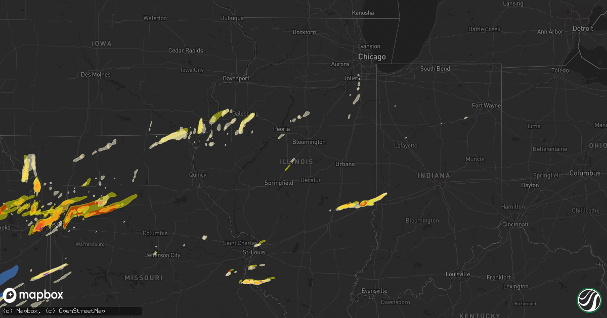
Hail Map in Illinois on March 13, 2024
Get this storm
March 13 map
$229
one time, instant access
Download today. No call, no setup
Keep the $229
Bought the map and want the full workflow? Apply the entire $229 to a subscription within 7 days. None of it is wasted.
Every map, not just this one
This buys you this map. Subscription and you get every map we run, in the markets you choose from a few cities to whole states to nationwide. Plus real-time alerts the moment a storm fires.
Contact data
Name, contact info, occupancy, even credit band for addresses in the footprint. You go from where it hit to who to call.
Become the source they trust
Unlimited branding weather history reports on demand. You already have the documented answer ready for the property owner, and you are the one who showed up with it.
Property data and RoofTrace estimates
Pull up any address you have got, its value and the exact code rules for that jurisdiction, straight from One Click Code. Then RoofTrace estimates the squares, pitch, and roof value, priced the way you price.
Storm reports in Illinois
Illinois
| Date | Description |
|---|---|
| 03/13/20246:53 PM CDT | A local report indicates 1.00 inch wind near 2 ESE Columbia |
| 03/13/20245:56 PM CDT | Power lines down. |
| 03/13/20245:51 PM CDT | A local report indicates 1.75 inch wind near Renault |
| 03/13/20245:50 PM CDT | A local report indicates 1.75 inch wind near Ruma |
| 03/13/20245:49 PM CDT | A local report indicates 1.75 inch wind near Ames |
| 03/13/20245:47 PM CDT | Hail was mostly the size of pennies and dimes... But observer did see quarter size hail mixed in. |
| 03/13/20245:36 PM CDT | Report from mping: quarter |
| 03/13/20245:32 PM CDT | A local report indicates 1.00 inch wind near 1 SE Renault |
| 03/13/20244:20 AM CDT | Measured by a private weather station. |
| 03/13/20244:04 AM CDT | A local report indicates 62 MPH wind near 4 SE Blandinsville |
| 03/13/20241:35 AM CDT | Damage to a grain bin. Time estimated with radar. |
| 03/12/202411:30 PM CDT | Relayed via wcia-tv. |
| 03/12/20249:41 PM CDT | Reports of dented cars as well. |
| 03/12/20248:37 PM CDT | Report from mping: quarter |
| 03/12/20248:31 PM CDT | Social media photo of half dollar size hail. |
| 03/12/20248:31 PM CDT | Half dollar to golf ball size hail at bent tree golf course. Relayed via broadcast media. |
| 03/12/20248:23 PM CDT | A local report indicates 1.00 inch wind near 2 WNW Edwardsville |
| 03/12/20248:10 PM CDT | A local report indicates 1.00 inch wind near Mitchell |
Cities Impacted by Hail Map on March 13, 2024
- De Soto, MO
- Festus, MO
- Fults, IL
- Valmeyer, IL
- Bloomsdale, MO
- Prairie Du Rocher, IL
- Dittmer, MO
- Cedar Hill, MO
- Red Bud, IL
- Evansville, IL
- Waterloo, IL
- Columbia, IL
- Baldwin, IL
- Burdick, KS
- Herington, KS
- Sparta, IL
- Dwight, KS
- White City, KS
- Council Grove, KS
- Gypsum, KS
- Assaria, KS
- Eudora, KS
- Linwood, KS
- De Soto, KS
- Junction City, KS
- Plainville, KS
- Tonganoxie, KS
- Palco, KS
- Ellis, KS
- Bonner Springs, KS
- Basehor, KS
- Shawnee, KS
- Lenexa, KS
- Kansas City, KS
- Alma, KS
- Leavenworth, KS
- Easton, KS
- Fort Leavenworth, KS
- Platte City, MO
- Jefferson City, MO
- Quinter, KS
- Collyer, KS
- Utica, KS
- Wakeeney, KS
- Ogallah, KS
- Alta Vista, KS
- Weston, MO
- Mission, KS
- Kansas City, MO
- Riverside, MO
- Lone Jack, MO
- Eugene, MO
- Stover, MO
- Lees Summit, MO
- Smithton, MO
- Greenwood, MO
- Knob Noster, MO
- Kingsville, MO
- Florence, MO
- Barnett, MO
- Leawood, KS
- Olean, MO
- Versailles, MO
- La Monte, MO
- Fortuna, MO
- Russellville, MO
- Mora, MO
- Warrensburg, MO
- Overland Park, KS
- Centerview, MO
- Pleasant Hill, MO
- Henley, MO
- Sedalia, MO
- Latham, MO
- Holden, MO
- Green Ridge, MO
- Wamego, KS
- McFarland, KS
- Granite City, IL
- Edwardsville, IL
- Chapman, KS
- Fort Riley, KS
- Riley, KS
- Ogden, KS
- Liberty, MO
- Trilla, IL
- Paxico, KS
- Lerna, IL
- Maple Hill, KS
- Saint Marys, KS
- Charleston, IL
- Rossville, KS
- Delia, KS
- Onaga, KS
- Vermillion, KS
- Belvue, KS
- Sand Springs, OK
- Westfield, IL
- Saint Joseph, MO
- Wathena, KS
- Elwood, KS
- Casey, IL
- Manhattan, KS
- Independence, MO
- Blue Springs, MO
- Buckner, MO
- Sibley, MO
- Orrick, MO
- Excelsior Springs, MO
- Kearney, MO
- Holt, MO
- Bartlesville, OK
- Ramona, OK
- Axtell, KS
- Nowata, OK
- Richmond, MO
- Rayville, MO
- Ashmore, IL
- Kansas, IL
- Mannford, OK
- Amazonia, MO
- Saint George, KS
- Lawson, MO
- Skiatook, OK
- Mayetta, KS
- Holton, KS
- Hoyt, KS
- Silver Lake, KS
- Hays, KS
- Marshall, IL
- Martinsville, IL
- Natoma, KS
- Paradise, KS
- Troy, KS
- Highland, KS
- Oregon, MO
- Forest City, MO
- Mound City, MO
- Paris, IL
- Camden, MO
- Hardin, MO
- Denison, KS
- Meriden, KS
- Valley Falls, KS
- Levasy, MO
- Carrollton, MO
- Norborne, MO
- Henrietta, MO
- Maitland, MO
- Dennison, IL
- Effingham, KS
- Nortonville, KS
- Luray, KS
- Waldo, KS
- Osborne, KS
- Lucas, KS
- Hunter, KS
- Sylvan Grove, KS
- Woodbine, KS
- Westmoreland, KS
- Eskridge, KS
- De Kalb, MO
- Rushville, MO
- Atchison, KS
- Catharine, KS
- Ransom, KS
- Linn, KS
- Clifton, KS
- Centertown, MO
- Narka, KS
- Toledo, IL
- Belleville, KS
- Agenda, KS
- Centralia, KS
- Hanover, KS
- Grubville, MO
- Luebbering, MO
- Neoga, IL
- Blue Rapids, KS
- Gove, KS
- Solomon, KS
- Portland, MO
- Rhineland, MO
- Cuba, KS
- Haddam, KS
- Hillsboro, MO
- Belleville, IL
- Smithton, IL
- Freeburg, IL
- Millstadt, IL
- Seneca, KS
- Baileyville, KS
- Dearborn, MO
- Clyde, KS
- Mahaska, KS
- Frankfort, KS
- Woodston, KS
- Enterprise, KS
- Topeka, KS
- Bogard, MO
- Tina, MO
- West Terre Haute, IN
- Cummings, KS
- Winchester, KS
- Oskaloosa, KS
- Lancaster, KS
- Beloit, KS
- Bosworth, MO
- Hale, MO
- Triplett, MO
- Mendon, MO
- Sumner, MO
- Miami, MO
- De Witt, MO
- Brunswick, MO
- Smithville, MO
- McLouth, KS
- Lansing, KS
- Memphis, MO
- Arbela, MO
- Luray, MO
- Mount Sterling, IA
- Kahoka, MO
- Farmington, IA
- Bonaparte, IA
- Keytesville, MO
- Dalton, MO
- Lathrop, MO
- Salisbury, MO
- Avon, IL
- Prairie City, IL
- Berwick, IL
- Saint Augustine, IL
- Abingdon, IL
- Donnellson, IA
- Polo, MO
- Cowgill, MO
- Skidmore, MO
- West Point, IA
- Fort Madison, IA
- Denmark, IA
- Wever, IA
- Danville, IA
- Braymer, MO
- Hamilton, MO
- Breckenridge, MO
- Chillicothe, MO
- Lock Springs, MO
- Jamesport, MO
- Elkhart, IL
- Williamsville, IL
- Middletown, IL
- Lincoln, IL
- Galesburg, IL
- Gilson, IL
- Knoxville, IL
- Farley, MO
- Dahinda, IL
- Burlington, IA
- Gladstone, IL
- Oquawka, IL
- Seaton, IL
- Monmouth, IL
- Little York, IL
- Virgil, KS
- Gridley, KS
- Garnett, KS
- Burlington, KS
- Yates Center, KS
- Richmond, KS
- Eureka, KS
- Hamilton, KS
- Waverly, KS
- Madison, KS
- Le Roy, KS
- Westphalia, KS
- Toronto, KS
- Piqua, KS
- Greenleaf, KS
- Palmer, KS
- Fillmore, MO
- Bolckow, MO
- Graham, MO
- Barnard, MO
- Dallas City, IL
- Metamora, IL
- Lowpoint, IL
- Carthage, IL
- Waterville, KS
- Princeton, MO
- Leonardville, KS
- Augusta, KS
- Rock, KS
- Leon, KS
- Atlanta, KS
- Udall, KS
- Douglass, KS
- Kankakee, IL
- Bourbonnais, IL
- Bonfield, IL
- Manteno, IL
- Smithshire, IL
- Roseville, IL
- Gorham, KS
- Russell, KS
- Carman, IL
- Newtown, MO
- Pollock, MO
- Powersville, MO
- Unionville, MO
- Harris, MO
- Lucerne, MO
- Ozawkie, KS
- Blandinsville, IL
- Washington, KS
- Morrowville, KS
- Clay Center, KS
- Goff, KS
- Braman, OK
- Dawn, MO
- Bethany, MO
- Raritan, IL
- Media, IL
- Medford, OK
- Victoria, KS
- Montrose, IA
- Keokuk, IA
- Morganville, KS
- Green, KS
- Tescott, KS
- Ethel, MO
- Elmer, MO
- El Dorado, KS
- Olsburg, KS
- Savannah, MO
- Lexington, MO
- Washburn, IL
- Roanoke, IL
- London Mills, IL
- Ellisville, IL
- Streator, IL
- Jonesburg, MO
- Warrenton, MO
- Winfield, KS
- Burden, KS
- Aurora, KS
- Concordia, KS
- Terre Haute, IN
- Rosedale, IN
- Lomax, IL
- New Cambria, MO
- Bucklin, MO
- South Haven, KS
- Clarksdale, MO
- Easton, MO
- Stewartsville, MO
- Benson, IL
- Minonk, IL
- Kingston, MO
- Bloomfield, IA
- Belle Plaine, KS
- Mulvane, KS
- Gower, MO
- Edgerton, MO
- Battle Ground, IN
- West Lafayette, IN
- Niota, IL
- Minneapolis, KS
- Blackwell, OK
- Nardin, OK
- Geuda Springs, KS
- Newkirk, OK
- Arkansas City, KS
- Gilman City, MO
- Stronghurst, IL
- Wayland, MO
- Downing, MO
- Cantril, IA
- Barnes, KS
- Randolph, KS
- Wellington, KS
- Good Hope, IL
- McFall, MO
- Pattonsburg, MO
- Faucett, MO
- Delphos, KS
- Colchester, IL
- Plattsburg, MO
- Rosalia, KS
- Oxford, KS
- Tipton, KS
- Pekin, IL
- Dover, MO
- Wellington, MO
- Helena, MO
- Union Star, MO
- Deer Creek, OK
- Trimble, MO
- East Peoria, IL
- Groveland, IL
- Bennington, KS
- Farmington, IL
- Yates City, IL
- Argyle, IA
- Camden Point, MO
- Gallatin, MO
- Linneus, MO
- Waldron, MO
- Napoleon, MO
- Chula, MO
- Centerville, KS
- Mound City, KS
- Pleasanton, KS
- La Cygne, KS
- Amoret, MO
- Amsterdam, MO
- Butler, MO
- Adrian, MO
- New Goshen, IN
- Concordia, MO
- Manhattan, IL
- Wilmington, IL
- Peotone, IL
- Peru, IN
- La Harpe, IL
- Soldier, KS
- Cameron, IL
- Cedar Vale, KS
- Melvern, KS
- Redfield, KS
- Uniontown, KS
- Hepler, KS
- Fort Scott, KS
- Parker, KS
- Rutland, IL
- Dana, IL
- Grenola, KS
- Andrews, IN
- Rich Hill, MO
- Foster, MO
- Severy, KS
- Howard, KS
- Longton, KS
- Sedan, KS
- Kincaid, KS
- Colony, KS
- La Harpe, KS
- Iola, KS
- Slater, MO
- Dexter, KS
- Moline, KS
- Sabetha, KS
- Sciota, IL
- Elk Falls, KS
- Long Point, IL
- Blue Mound, KS
- Fredonia, KS
- Orland Park, IL
- Mokena, IL
- Archie, MO
- Elsmore, KS
- Savonburg, KS
- Chanute, KS
- Erie, KS
- Bates City, MO
- Fall River, KS
- Buffalo, KS
- Benedict, KS
- Atlanta, IL
- Turney, MO
- Cameron, MO
- Grain Valley, MO
- Oak Grove, MO
- Homer Glen, IL
- Huntington, IN
- Hartsburg, MO
- Kidder, MO
- Monee, IL
- Frankfort, IL
- Glasgow, MO
- Ashkum, IL
- Kempton, IL
- New Lenox, IL
- Rensselaer, IN


