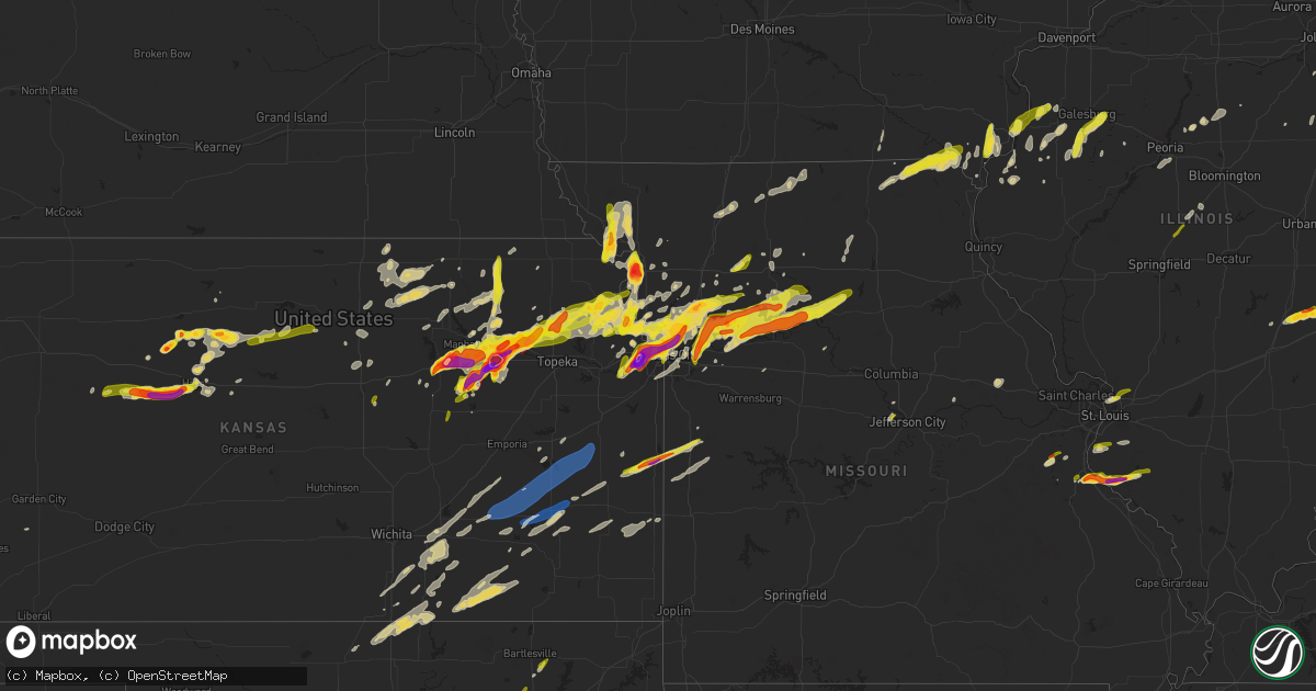
Hail Map on March 13, 2024
Get this storm
March 13 map
$229
one time, instant access
Download today. No call, no setup
Keep the $229
Bought the map and want the full workflow? Apply the entire $229 to a subscription within 7 days. None of it is wasted.
Every map, not just this one
This buys you this map. Subscription and you get every map we run, in the markets you choose from a few cities to whole states to nationwide. Plus real-time alerts the moment a storm fires.
Contact data
Name, contact info, occupancy, even credit band for addresses in the footprint. You go from where it hit to who to call.
Become the source they trust
Unlimited branding weather history reports on demand. You already have the documented answer ready for the property owner, and you are the one who showed up with it.
Property data and RoofTrace estimates
Pull up any address you have got, its value and the exact code rules for that jurisdiction, straight from One Click Code. Then RoofTrace estimates the squares, pitch, and roof value, priced the way you price.
Storm reports
Missouri
| Date | Description |
|---|---|
| 03/13/20245:41 PM CDT | A local report indicates 1.00 inch wind near 1 S Cedar Hill |
| 03/13/20244:53 PM CDT | A local report indicates 1.00 inch wind near 6 SSE Crystal City |
| 03/13/20244:53 PM CDT | Report from mping: half dollar |
| 03/13/20244:50 PM CDT | Reported as just under golf ball size hail. |
| 03/13/20244:42 PM CDT | Relayed via broadcast media from public... Time estimated via radar. |
| 03/13/20244:40 PM CDT | Relayed via broadcast media. |
| 03/13/20244:29 PM CDT | A local report indicates 1.00 inch wind near 1 W Olympian Village |
| 03/13/20244:15 PM CDT | Relayed via broadcast media... Time estimated from radar. |
| 03/13/20246:18 AM CDT | A local report indicates 1.00 inch wind near Adrian |
| 03/13/20244:20 AM CDT | Delayed report from earlier this morning. Minor damage to a barn with some sides peeled. |
| 03/13/20244:15 AM CDT | Delayed report of minor barn damage and tree limbs down from this mornings storms. |
| 03/13/20244:09 AM CDT | Downed power lines and power outages from a severe thunderstorm near the town of leeton. Time estimated from radar. |
| 03/13/20243:47 AM CDT | Downed power lines and power outages from a severe thunderstorm near ramson road. Time estimated from radar. |
| 03/13/20243:35 AM CDT | Downed power lines and power outages from a severe thunderstorm near school road and 195th street. Over 1000 customers without power. Time estimated from radar. |
| 03/13/20243:33 AM CDT | Downed power lines and power outages near georgian drive. Time estimated from radar. |
| 03/13/20243:29 AM CDT | Downed power lines and power outages from a severe thunderstorm near white oak street. Several hundred customers without power. Time estimated from radar. |
| 03/13/20243:14 AM CDT | Downed power lines and power outages from a severe thunderstorm near holmes road. Time estimated from radar. |
| 03/13/20243:06 AM CDT | Large tree down. Diameter unknown. |
| 03/13/20242:26 AM CDT | Social media report of quarter size hail in parkville. Time |
| 03/13/20242:26 AM CDT | Social media report of quarter size hail in parkville. Time estimated from radar. |
| 03/13/20242:16 AM CDT | Downed trees and wires near county road 1305. Time estimated from radar. |
| 03/13/20242:14 AM CDT | Corrects previous tstm wnd dmg report from 3 nnw moberly. Downed trees and wires near county road 1305. Time estimated from radar. |
| 03/13/20242:14 AM CDT | A local report indicates 61 MPH wind near 3 N Moberly |
| 03/13/20242:14 AM CDT | Downed trees and wires near county road 1330. Time estimated from radar. |
| 03/13/20241:59 AM CDT | Remarks pk wnd 30051/0659. |
| 03/13/20241:16 AM CDT | Downed trees and wires near route 11. Time estimated from radar. |
| 03/13/202412:46 AM CDT | Report from mping: quarter |
| 03/13/202412:45 AM CDT | A local report indicates 1.00 inch wind near 6 NNE Oakview |
| 03/13/202412:37 AM CDT | Report from mping: quarter |
| 03/13/202412:31 AM CDT | A local report indicates 1.00 inch wind near 2 S Ferrelview |
| 03/13/202412:31 AM CDT | (ea |
| 03/13/202412:29 AM CDT | A local report indicates 1.00 inch wind near Breckenridge |
| 03/13/202412:24 AM CDT | Social media report. |
| 03/12/202411:48 PM CDT | Golf ball size hail reported between holt and kearney via social media. Time estimated from radar. |
| 03/12/202411:29 PM CDT | Hail up to half dollar sized. Hail covering ground. |
| 03/12/202411:27 PM CDT | Komu viewer reports multiple quarter size hail stones. |
| 03/12/202411:20 PM CDT | Downed power lines and power outages from a severe thunderstorm near route w south of cook road. Time estimated from radar. |
| 03/12/202411:15 PM CDT | Media relayed a report and multiple photos and videos of up to quarter size hail covering the ground in the brunswick area. Strong winds also reported... Resulting in h |
| 03/12/202411:05 PM CDT | Nws employee reported 1 hail in platte county. |
| 03/12/202410:59 PM CDT | Quarter size hail near hampton road and route 45. |
| 03/12/202410:55 PM CDT | Report from mping: quarter |
| 03/12/202410:49 PM CDT | Social media report of quarter size hail covering the ground approximately six miles east of carrollton. Time estimated from radar. |
| 03/12/202410:42 PM CDT | A local report indicates 1.25 inch wind near 3 NW Anson |
| 03/12/202410:34 PM CDT | Trained spotter reported golf ball size hail in carrolton. Time estimated from radar. |
| 03/12/202410:27 PM CDT | Hail up to quarter size covering the ground. Time estimated from radar. |
| 03/12/20249:57 PM CDT | Downed power lines and power outages from thunderstorm winds near 270th street and highway z. Time estimated from radar. |
| 03/12/20249:52 PM CDT | Report from mping: half dollar |
| 03/12/20249:40 PM CDT | Mping report of quarter size hail. Time estimated from radar. |
| 03/12/20249:34 PM CDT | Photo of hail up to ping pong ball size in oregon. Time confirmed by radar. |
| 03/12/20249:28 PM CDT | Report from mping: quarter |
| 03/12/20249:28 PM CDT | Quarter size hail reported in oregon. Time estimated from radar. |
| 03/12/20249:28 PM CDT | Photo of hail up to golf ball size hail in richmond. Time estimated from radar. |
| 03/12/20249:25 PM CDT | Up to golf ball sized hail reported by the public 1 mile southeast of richmond. |
| 03/12/20249:20 PM CDT | Photo of quarter size hail in rayville. Time estimated from radar. |
| 03/12/20249:07 PM CDT | Report from mping: ping pong ball |
| 03/12/20248:58 PM CDT | Quarter-sized hail falling in st. Joseph |
| 03/12/20248:54 PM CDT | Report from mping: quarter |
| 03/12/20248:53 PM CDT | Report from mping: half dollar |
| 03/12/20248:50 PM CDT | Downed power lines and power outages from thunderstorm winds and hail near 112th street and route a. Time estimated from radar. |
| 03/12/20248:46 PM CDT | Photo of approximately ping pong ball sized hail from a resident in buckner. Time estimated from radar. |
| 03/12/20248:45 PM CDT | Walnut size hail near shoal creek parkway west of liberty. Time estimated from radar. |
| 03/12/20248:45 PM CDT | Hail reported near hwy 1 and hwy 152. |
| 03/12/20248:43 PM CDT | Golf ball size hail on the far south side of saint joseph. Photo provided via social media. |
| 03/12/20248:43 PM CDT | Photo of golf ball sized hail at benton high school. Time estimated from radar. |
| 03/12/20248:43 PM CDT | Report from mping: quarter |
| 03/12/20248:43 PM CDT | Photo of ping pong ball sized hail in pleasant valley. Time estimated from radar. |
| 03/12/20248:43 PM CDT | Report from mping: quarter |
| 03/12/20248:41 PM CDT | Spotter reported 1 inch hail and the ground is white with hail. |
| 03/12/20248:40 PM CDT | Photo of ping pong ball sized hail in liberty. Time confirmed from radar. |
| 03/12/20248:39 PM CDT | Quarter size hail near worlds of fun. Photo via social media. Time estimated from radar. |
| 03/12/20248:39 PM CDT | Report from mping: ping pong ball |
| 03/12/20248:35 PM CDT | Photo of golf ball size hail near route 291 and withers road. Time estimated from radar. |
| 03/12/20248:34 PM CDT | Power outages from thunderstorm winds near r d mize road. Time estimated from radar. |
| 03/12/20248:33 PM CDT | Report from mping: quarter |
| 03/12/20248:27 PM CDT | Downed power lines and power outages from a severe thunderstorm near birmingham road. Time estimated from radar. |
| 03/12/20248:27 PM CDT | Downed power lines and power outages near forest avenue. Time estimated from radar. |
| 03/12/20248:26 PM CDT | Severe storm damaged power lines near congress avenue. Time estimated from radar. |
| 03/12/20248:23 PM CDT | Social media photo of quarter size hail in riverside. Time estimated from radar. |
| 03/12/20248:22 PM CDT | Quarter size hail on the west side of parkville. Time estimated from radar. |
| 03/12/20248:14 PM CDT | Downed power lines and power outages from a severe thunderstorm near pacific street. Time estimated from radar. |
| 03/12/20248:00 PM CDT | Severe thunderstorms with large hail and torrential rainfall resulted in temporary stranded traffic and road closures... Including on i-35 and i-70... Between 730 and 9 |
| 03/12/20247:55 PM CDT | Report from mping: half dollar |
| 03/12/20247:54 PM CDT | Report from mping: half dollar |
| 03/12/20247:34 PM CDT | Time estimated via radar. |
| 03/12/20247:24 PM CDT | A local report indicates 1.25 inch wind near Saint Martins |
California
| Date | Description |
|---|---|
| 03/12/202410:57 PM CDT | Mesonet station wtpc1 whitaker peak raws. |
Indiana
| Date | Description |
|---|---|
| 03/12/202410:42 PM CDT | A local report indicates 1.50 inch wind near 3 WSW Shepardsville |
Kansas
| Date | Description |
|---|---|
| 03/13/20246:55 PM CDT | Public report of hail up to golf ball size one mile in from very southwest corner of rooks county. Time estimated from radar. |
| 03/13/20242:00 AM CDT | Personal weather station. |
| 03/13/20241:20 AM CDT | A local report indicates 61 MPH wind near Lillis |
| 03/13/20241:19 AM CDT | Measured at eureka municipal airport. |
| 03/12/202411:46 PM CDT | Emergency manager reports up to quarter size hail covering the ground on k-92 near 195th street. Time based on dispatch report and confirmed by radar. |
| 03/12/202411:38 PM CDT | Social media report of up to quarter size hail in fort leavenworth. Time estimated from radar. |
| 03/12/202411:30 PM CDT | Public estimated 60 mph wind gusts just north of minneapolis on highway 81. Called into dispatch. |
| 03/12/202410:57 PM CDT | Quarter size hail reported in springdale. Time estimated from radar. |
| 03/12/202410:12 PM CDT | Report from mpi |
| 03/12/202410:12 PM CDT | Report from mping: quarter |
| 03/12/202410:08 PM CDT | A local report indicates 1.00 inch wind near 3 NE Valley Falls |
| 03/12/20249:45 PM CDT | A local report indicates 1.00 inch wind near 13 SW Tipton |
| 03/12/20249:45 PM CDT | A local report indicates 2.00 inch wind near 2 N Paxico |
| 03/12/20249:42 PM CDT | Report via twitter. |
| 03/12/20249:42 PM CDT | Report via twitter. |
| 03/12/20249:32 PM CDT | A local report indicates 1.00 inch wind near 4 NW Emmeram |
| 03/12/20249:32 PM CDT | Ground covered in quarter size hail in wamego reported by law enforcement relayed by em. |
| 03/12/20249:30 PM CDT | Report was from social media. |
| 03/12/20249:30 PM CDT | A local report indicates 1.00 inch wind near 3 ENE Hoyt |
| 03/12/20249:29 PM CDT | Report from mping: quarter |
| 03/12/20249:22 PM CDT | Ping pong size hail reported by spotter. |
| 03/12/20249:21 PM CDT | Report from mping: quarter |
| 03/12/20249:21 PM CDT | A local report indicates 1.00 inch wind near 2 SSE Hays |
| 03/12/20249:20 PM CDT | Report was from social media. |
| 03/12/20249:20 PM CDT | Report was from social media. |
| 03/12/20249:20 PM CDT | Corrects previous hail report from 5 sse manhattan. Report from mping: hen egg |
| 03/12/20249:17 PM CDT | Quarter size hail reported by emergency management. |
| 03/12/20249:12 PM CDT | Report was from social media. |
| 03/12/20249:11 PM CDT | Corrected location previous hail report from 6 ne codell. |
| 03/12/20249:11 PM CDT | A local report indicates 1.50 inch wind near 6 NE Codell |
| 03/12/20249:10 PM CDT | On deep creek road south of manhattan. |
| 03/12/20249:03 PM CDT | Report from mping: golf ball |
| 03/12/20249:02 PM CDT | Delayed report. |
| 03/12/20249:00 PM CDT | Report from mping: ping pong ball |
| 03/12/20249:00 PM CDT | Report from mping: quarter |
| 03/12/20249:00 PM CDT | Picture from facebook. |
| 03/12/20248:56 PM CDT | Social media post and photo of approximately tennis ball size hail in wathena. Time estimated from radar. |
| 03/12/20248:50 PM CDT | Corrects previous hail report time and location previous hail report from 6 ne codell. |
| 03/12/20248:50 PM CDT | Hail fell at 99th and leavenworth road in kck. Public reported. |
| 03/12/20248:40 PM CDT | A local report indicates 1.75 inch wind near 5 E Cedar Bluff |
| 03/12/20248:39 PM CDT | A local report indicates 2.00 inch wind near 9 ESE Cedar Bluff |
| 03/12/20248:33 PM CDT | Public reports relayed by emergency management of a tornado on the ground at 62nd and valencia near rossvile. |
| 03/12/20248:30 PM CDT | Damage to cars and house shingles. |
| 03/12/20248:30 PM CDT | Baseball size hail reported via emergency management. |
| 03/12/20248:24 PM CDT | 2 inch hail at the grandview plaza exit on i-70. Time estimated from radar. |
| 03/12/20248:24 PM CDT | Report from mping: ping pong ball |
| 03/12/20248:23 PM CDT | Downed trees and wires near tenny avenue. Time estimated from radar. |
| 03/12/20248:21 PM CDT | Report from mping: ping pong ball |
| 03/12/20248:21 PM CDT | Report from mping: ping pong |
| 03/12/20248:20 PM CDT | Social media report of wind damage at a residence... Including to multiple fences and a porch. Large hail also damaged windows and door screens. Time and location estim |
| 03/12/20248:18 PM CDT | Report from mping: quarter |
| 03/12/20248:17 PM CDT | A local report indicates 1.50 inch wind near Grandview Plaza |
| 03/12/20248:15 PM CDT | Law enformcement reporting a tornado on the ground. |
| 03/12/20248:14 PM CDT | Photo of golf ball sized hail in kansas city... Ks. Time and location estimated from radar. |
| 03/12/20248:12 PM CDT | Quarter sized hail on johnson drive east of i-435. |
| 03/12/20248:12 PM CDT | A local report indicates 2.00 inch wind near 4 SW Cedar Bluff |
| 03/12/20248:10 PM CDT | A local report indicates 1.00 inch wind near 3 SSW Cedar Bluff |
| 03/12/20248:10 PM CDT | Hail covering the ground and size at least a quarter sized. |
| 03/12/20248:10 PM CDT | Downed tree and wires near argentine boulevard. Time estimated from radar. |
| 03/12/20248:10 PM CDT | 89th & anne ave.... Kck golf ball sized hail and heavy rain. |
| 03/12/20248:08 PM CDT | Softball size hail reported by law enforcement 2 wsw of alma. |
| 03/12/20248:07 PM CDT | Report from mping: half dollar |
| 03/12/20248:05 PM CDT | Downed tree and wires near powell avenue. Time estimated from radar. |
| 03/12/20248:05 PM CDT | Broadcast media reports tennis ball sized hail in edwardsville. Time confirmed from radar. |
| 03/12/20248:04 PM CDT | Report from mping: golf ball . Time estimated from radar. Radar. |
| 03/12/20248:04 PM CDT | Report from mping: golf ball |
| 03/12/20248:03 PM CDT | A local report indicates 1.50 inch wind near 3 SW Junction City |
| 03/12/20248:03 PM CDT | Ping pong ball sized hail near 99th street and leavenworth road. Time confirmed from radar. |
| 03/12/20248:02 PM CDT | Baseball sized hail damaged car windows. Time estimated from radar. |
| 03/12/20248:02 PM CDT | Report from mping: half dollar |
| 03/12/20248:02 PM CDT | Delayed report: 1 rancher reported 5 barns damaged... But no damage to his residence. Time estimated from radar. |
| 03/12/20248:02 PM CDT | Report from mping: quarter |
| 03/12/20248:02 PM CDT | A local report indicates 1.00 inch wind near Junction City |
| 03/12/20248:01 PM CDT | Quarter size hail at 99th and leavenworth road in kck. |
| 03/12/20248:00 PM CDT | Photo of two inch diameter hail near 64th and woodland. Time estimated from radar. |
| 03/12/20248:00 PM CDT | Two inch hail in mill valley with broken windshields. Time estimated from radar. |
| 03/12/20248:00 PM CDT | Photo of approximately tennis ball sized hail near 64th and monticello. Time confirmed from radar. |
| 03/12/20247:58 PM CDT | Severe storm damaged power lines and produced power outages south of maywood. Time estimated from radar. |
| 03/12/20247:57 PM CDT | Inch and a half sized hail reported at 167th/coffin road north of fort leavenworth... Ks |
| 03/12/20247:57 PM CDT | Photo of two-inch diameter hail just west of edwardsville. Time estimated from radar. |
| 03/12/20247:57 PM CDT | Photo of baseball sized hail in shawnee. Time estimated from radar. |
| 03/12/20247:55 PM CDT | Hail measured at 3.5 inches in diameter at 55th street and mccormick drive. Photo provided to trained spotter and relayed to the office. Time estimated from radar. |
| 03/12/20247:55 PM CDT | Photo of golf ball size hail just north of kansas speedway. Time estimated from radar. |
| 03/12/20247:54 PM CDT | Report from mping: baseball |
| 03/12/20247:54 PM CDT | Golf ball sized hail at the intersection of 64th street and monticello road. |
| 03/12/20247:52 PM CDT | Photo of golf ball sized hail in bonner springs. Time estimated from radar. |
| 03/12/20247:50 PM CDT | A local report indicates a tornado near 3 NE Alta Vista |
| 03/12/20247:50 PM CDT | Hail up to tennis ball size near 64th street and brockway street. Time estimated from radar. |
| 03/12/20247:50 PM CDT | A local report indicates 1.50 inch wind near 3 ESE Zurich |
| 03/12/20247:50 PM CDT | Photo of two-inch diameter hail near mill valley high school. Time estimated from radar. |
| 03/12/20247:46 PM CDT | A local report indicates 1.25 inch wind near 9 S Trego Center |
| 03/12/20247:45 PM CDT | Quarter sized hail near 158th street and loring rd. |
| 03/12/20247:40 PM CDT | Mping report of quarter sized hail. Time confirmed from radar. |
| 03/12/20247:38 PM CDT | Photo of approximately half dollar size hail in the western side of lenexa. Time estimated from radar. |
| 03/12/20247:36 PM CDT | Nickel to quarter sized hail at 166th street and golden road. |
| 03/12/20247:36 PM CDT | A local report indicates 1.00 inch wind near 6 SW Trego Center |
| 03/12/20247:34 PM CDT | Ping pong ball size hail reported in alma. |
| 03/12/20247:34 PM CDT | Ping pong ball size hail reported in alma. |
| 03/12/20247:30 PM CDT | Delayed report. 1.75 inch hail near the geary morris county line north of dwight. Time estimated from radar. |
| 03/12/20247:30 PM CDT | Delayed report. 1.75 inch hail near the geary morris county line north of dwight. Time estimated from radar. |
| 03/12/20247:30 PM CDT | A resident reported quarter sized hail in de soto. Time confirmed from radar. |
| 03/12/20247:22 PM CDT | A local report indicates 1.00 inch wind near 10 SW Trego Center |
| 03/12/20247:22 PM CDT | Mostly small hail... A few quarter sized. |
| 03/12/20247:21 PM CDT | Quarter sized hail at the intersection of state highway 10 and edgerton road. |
| 03/12/20247:18 PM CDT | Hail up to half dollar size ongoing. |
| 03/12/20247:11 PM CDT | Quarter sized hail reported just south of linwood. Time estimated from radar. |
| 03/12/20247:11 PM CDT | A local report indicates 1.00 inch wind near 12 S Collyer |
| 03/12/20247:01 PM CDT | 10 minutes of hail... Pea to quarter sized... Hail completely covering ground. |
Arkansas
| Date | Description |
|---|---|
| 03/13/20242:21 AM CDT | Social media report relayed by broadcast media. |
Iowa
| Date | Description |
|---|---|
| 03/13/202412:00 AM CDT | Facebook photo of ping pong ball size hail. |
Illinois
| Date | Description |
|---|---|
| 03/13/20246:53 PM CDT | A local report indicates 1.00 inch wind near 2 ESE Columbia |
| 03/13/20245:56 PM CDT | Power lines down. |
| 03/13/20245:51 PM CDT | A local report indicates 1.75 inch wind near Renault |
| 03/13/20245:50 PM CDT | A local report indicates 1.75 inch wind near Ruma |
| 03/13/20245:49 PM CDT | A local report indicates 1.75 inch wind near Ames |
| 03/13/20245:47 PM CDT | Hail was mostly the size of pennies and dimes... But observer did see quarter size hail mixed in. |
| 03/13/20245:36 PM CDT | Report from mping: quarter |
| 03/13/20245:32 PM CDT | A local report indicates 1.00 inch wind near 1 SE Renault |
| 03/13/20244:20 AM CDT | Measured by a private weather station. |
| 03/13/20244:04 AM CDT | A local report indicates 62 MPH wind near 4 SE Blandinsville |
| 03/13/20241:35 AM CDT | Damage to a grain bin. Time estimated with radar. |
| 03/12/202411:30 PM CDT | Relayed via wcia-tv. |
| 03/12/20249:41 PM CDT | Reports of dented cars as well. |
| 03/12/20248:37 PM CDT | Report from mping: quarter |
| 03/12/20248:31 PM CDT | Half dollar to golf ball size hail at bent tree golf course. Relayed via broadcast media. |
| 03/12/20248:31 PM CDT | Social media photo of half dollar size hail. |
| 03/12/20248:23 PM CDT | A local report indicates 1.00 inch wind near 2 WNW Edwardsville |
| 03/12/20248:10 PM CDT | A local report indicates 1.00 inch wind near Mitchell |
Oklahoma
| Date | Description |
|---|---|
| 03/12/20249:00 PM CDT | A local report indicates 1.00 inch wind near 7 ENE Ochelata |
| 03/12/20248:42 PM CDT | Report from mping: quarter |
| 03/12/20248:25 PM CDT | A local report indicates 1.00 inch wind near Mannford |
Cities Impacted by Hail Map on March 13, 2024
- De Soto, MO
- Festus, MO
- Fults, IL
- Valmeyer, IL
- Bloomsdale, MO
- Prairie Du Rocher, IL
- Dittmer, MO
- Cedar Hill, MO
- Red Bud, IL
- Evansville, IL
- Waterloo, IL
- Columbia, IL
- Baldwin, IL
- Burdick, KS
- Herington, KS
- Sparta, IL
- Dwight, KS
- White City, KS
- Council Grove, KS
- Gypsum, KS
- Assaria, KS
- Eudora, KS
- Linwood, KS
- De Soto, KS
- Junction City, KS
- Plainville, KS
- Tonganoxie, KS
- Palco, KS
- Ellis, KS
- Bonner Springs, KS
- Basehor, KS
- Shawnee, KS
- Lenexa, KS
- Kansas City, KS
- Alma, KS
- Leavenworth, KS
- Easton, KS
- Fort Leavenworth, KS
- Platte City, MO
- Jefferson City, MO
- Quinter, KS
- Collyer, KS
- Utica, KS
- Wakeeney, KS
- Ogallah, KS
- Alta Vista, KS
- Weston, MO
- Mission, KS
- Kansas City, MO
- Riverside, MO
- Lone Jack, MO
- Eugene, MO
- Stover, MO
- Lees Summit, MO
- Smithton, MO
- Greenwood, MO
- Knob Noster, MO
- Kingsville, MO
- Florence, MO
- Barnett, MO
- Leawood, KS
- Olean, MO
- Versailles, MO
- La Monte, MO
- Fortuna, MO
- Russellville, MO
- Mora, MO
- Warrensburg, MO
- Overland Park, KS
- Centerview, MO
- Pleasant Hill, MO
- Henley, MO
- Sedalia, MO
- Latham, MO
- Holden, MO
- Green Ridge, MO
- Wamego, KS
- McFarland, KS
- Granite City, IL
- Edwardsville, IL
- Chapman, KS
- Fort Riley, KS
- Riley, KS
- Ogden, KS
- Liberty, MO
- Trilla, IL
- Paxico, KS
- Lerna, IL
- Maple Hill, KS
- Saint Marys, KS
- Charleston, IL
- Rossville, KS
- Delia, KS
- Onaga, KS
- Vermillion, KS
- Belvue, KS
- Sand Springs, OK
- Westfield, IL
- Saint Joseph, MO
- Wathena, KS
- Elwood, KS
- Casey, IL
- Manhattan, KS
- Independence, MO
- Blue Springs, MO
- Buckner, MO
- Sibley, MO
- Orrick, MO
- Excelsior Springs, MO
- Kearney, MO
- Holt, MO
- Bartlesville, OK
- Ramona, OK
- Axtell, KS
- Nowata, OK
- Richmond, MO
- Rayville, MO
- Ashmore, IL
- Kansas, IL
- Mannford, OK
- Amazonia, MO
- Saint George, KS
- Lawson, MO
- Skiatook, OK
- Mayetta, KS
- Holton, KS
- Hoyt, KS
- Silver Lake, KS
- Hays, KS
- Marshall, IL
- Martinsville, IL
- Natoma, KS
- Paradise, KS
- Troy, KS
- Highland, KS
- Oregon, MO
- Forest City, MO
- Mound City, MO
- Paris, IL
- Camden, MO
- Hardin, MO
- Denison, KS
- Meriden, KS
- Valley Falls, KS
- Levasy, MO
- Carrollton, MO
- Norborne, MO
- Henrietta, MO
- Maitland, MO
- Dennison, IL
- Effingham, KS
- Nortonville, KS
- Luray, KS
- Waldo, KS
- Osborne, KS
- Lucas, KS
- Hunter, KS
- Sylvan Grove, KS
- Woodbine, KS
- Westmoreland, KS
- Eskridge, KS
- De Kalb, MO
- Rushville, MO
- Atchison, KS
- Catharine, KS
- Ransom, KS
- Linn, KS
- Clifton, KS
- Centertown, MO
- Narka, KS
- Toledo, IL
- Belleville, KS
- Agenda, KS
- Centralia, KS
- Hanover, KS
- Grubville, MO
- Luebbering, MO
- Neoga, IL
- Blue Rapids, KS
- Gove, KS
- Solomon, KS
- Portland, MO
- Rhineland, MO
- Cuba, KS
- Haddam, KS
- Hillsboro, MO
- Belleville, IL
- Smithton, IL
- Freeburg, IL
- Millstadt, IL
- Seneca, KS
- Baileyville, KS
- Dearborn, MO
- Clyde, KS
- Mahaska, KS
- Frankfort, KS
- Woodston, KS
- Enterprise, KS
- Topeka, KS
- Bogard, MO
- Tina, MO
- West Terre Haute, IN
- Cummings, KS
- Winchester, KS
- Oskaloosa, KS
- Lancaster, KS
- Beloit, KS
- Bosworth, MO
- Hale, MO
- Triplett, MO
- Mendon, MO
- Sumner, MO
- Miami, MO
- De Witt, MO
- Brunswick, MO
- Smithville, MO
- McLouth, KS
- Lansing, KS
- Memphis, MO
- Arbela, MO
- Luray, MO
- Mount Sterling, IA
- Kahoka, MO
- Farmington, IA
- Bonaparte, IA
- Keytesville, MO
- Dalton, MO
- Lathrop, MO
- Salisbury, MO
- Avon, IL
- Prairie City, IL
- Berwick, IL
- Saint Augustine, IL
- Abingdon, IL
- Donnellson, IA
- Polo, MO
- Cowgill, MO
- Skidmore, MO
- West Point, IA
- Fort Madison, IA
- Denmark, IA
- Wever, IA
- Danville, IA
- Braymer, MO
- Hamilton, MO
- Breckenridge, MO
- Chillicothe, MO
- Lock Springs, MO
- Jamesport, MO
- Elkhart, IL
- Williamsville, IL
- Middletown, IL
- Lincoln, IL
- Galesburg, IL
- Gilson, IL
- Knoxville, IL
- Farley, MO
- Dahinda, IL
- Burlington, IA
- Gladstone, IL
- Oquawka, IL
- Seaton, IL
- Monmouth, IL
- Little York, IL
- Virgil, KS
- Gridley, KS
- Garnett, KS
- Burlington, KS
- Yates Center, KS
- Richmond, KS
- Eureka, KS
- Hamilton, KS
- Waverly, KS
- Madison, KS
- Le Roy, KS
- Westphalia, KS
- Toronto, KS
- Piqua, KS
- Greenleaf, KS
- Palmer, KS
- Fillmore, MO
- Bolckow, MO
- Graham, MO
- Barnard, MO
- Dallas City, IL
- Metamora, IL
- Lowpoint, IL
- Carthage, IL
- Waterville, KS
- Princeton, MO
- Leonardville, KS
- Augusta, KS
- Rock, KS
- Leon, KS
- Atlanta, KS
- Udall, KS
- Douglass, KS
- Kankakee, IL
- Bourbonnais, IL
- Bonfield, IL
- Manteno, IL
- Smithshire, IL
- Roseville, IL
- Gorham, KS
- Russell, KS
- Carman, IL
- Newtown, MO
- Pollock, MO
- Powersville, MO
- Unionville, MO
- Harris, MO
- Lucerne, MO
- Ozawkie, KS
- Blandinsville, IL
- Washington, KS
- Morrowville, KS
- Clay Center, KS
- Goff, KS
- Braman, OK
- Dawn, MO
- Bethany, MO
- Raritan, IL
- Media, IL
- Medford, OK
- Victoria, KS
- Montrose, IA
- Keokuk, IA
- Morganville, KS
- Green, KS
- Tescott, KS
- Ethel, MO
- Elmer, MO
- El Dorado, KS
- Olsburg, KS
- Savannah, MO
- Lexington, MO
- Washburn, IL
- Roanoke, IL
- London Mills, IL
- Ellisville, IL
- Streator, IL
- Jonesburg, MO
- Warrenton, MO
- Winfield, KS
- Burden, KS
- Aurora, KS
- Concordia, KS
- Terre Haute, IN
- Rosedale, IN
- Lomax, IL
- New Cambria, MO
- Bucklin, MO
- South Haven, KS
- Clarksdale, MO
- Easton, MO
- Stewartsville, MO
- Benson, IL
- Minonk, IL
- Kingston, MO
- Bloomfield, IA
- Belle Plaine, KS
- Mulvane, KS
- Gower, MO
- Edgerton, MO
- Battle Ground, IN
- West Lafayette, IN
- Niota, IL
- Minneapolis, KS
- Blackwell, OK
- Nardin, OK
- Geuda Springs, KS
- Newkirk, OK
- Arkansas City, KS
- Gilman City, MO
- Stronghurst, IL
- Wayland, MO
- Downing, MO
- Cantril, IA
- Barnes, KS
- Randolph, KS
- Wellington, KS
- Good Hope, IL
- McFall, MO
- Pattonsburg, MO
- Faucett, MO
- Delphos, KS
- Colchester, IL
- Plattsburg, MO
- Rosalia, KS
- Oxford, KS
- Tipton, KS
- Pekin, IL
- Dover, MO
- Wellington, MO
- Helena, MO
- Union Star, MO
- Deer Creek, OK
- Trimble, MO
- East Peoria, IL
- Groveland, IL
- Bennington, KS
- Farmington, IL
- Yates City, IL
- Argyle, IA
- Camden Point, MO
- Gallatin, MO
- Linneus, MO
- Waldron, MO
- Napoleon, MO
- Chula, MO
- Centerville, KS
- Mound City, KS
- Pleasanton, KS
- La Cygne, KS
- Amoret, MO
- Amsterdam, MO
- Butler, MO
- Adrian, MO
- New Goshen, IN
- Concordia, MO
- Manhattan, IL
- Wilmington, IL
- Peotone, IL
- Peru, IN
- La Harpe, IL
- Soldier, KS
- Cameron, IL
- Cedar Vale, KS
- Melvern, KS
- Redfield, KS
- Uniontown, KS
- Hepler, KS
- Fort Scott, KS
- Parker, KS
- Rutland, IL
- Dana, IL
- Grenola, KS
- Andrews, IN
- Rich Hill, MO
- Foster, MO
- Severy, KS
- Howard, KS
- Longton, KS
- Sedan, KS
- Kincaid, KS
- Colony, KS
- La Harpe, KS
- Iola, KS
- Slater, MO
- Dexter, KS
- Moline, KS
- Sabetha, KS
- Sciota, IL
- Elk Falls, KS
- Long Point, IL
- Blue Mound, KS
- Fredonia, KS
- Orland Park, IL
- Mokena, IL
- Archie, MO
- Elsmore, KS
- Savonburg, KS
- Chanute, KS
- Erie, KS
- Bates City, MO
- Fall River, KS
- Buffalo, KS
- Benedict, KS
- Atlanta, IL
- Turney, MO
- Cameron, MO
- Grain Valley, MO
- Oak Grove, MO
- Homer Glen, IL
- Huntington, IN
- Hartsburg, MO
- Kidder, MO
- Monee, IL
- Frankfort, IL
- Glasgow, MO
- Ashkum, IL
- Kempton, IL
- New Lenox, IL
- Rensselaer, IN