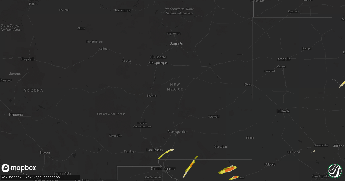
Hail Map in New Mexico on March 13, 2020
Get this storm
March 13 map
$229
one time, instant access
Download today. No call, no setup
Keep the $229
Bought the map and want the full workflow? Apply the entire $229 to a subscription within 7 days. None of it is wasted.
Every map, not just this one
This buys you this map. Subscription and you get every map we run, in the markets you choose from a few cities to whole states to nationwide. Plus real-time alerts the moment a storm fires.
Contact data
Name, contact info, occupancy, even credit band for addresses in the footprint. You go from where it hit to who to call.
Become the source they trust
Unlimited branding weather history reports on demand. You already have the documented answer ready for the property owner, and you are the one who showed up with it.
Property data and RoofTrace estimates
Pull up any address you have got, its value and the exact code rules for that jurisdiction, straight from One Click Code. Then RoofTrace estimates the squares, pitch, and roof value, priced the way you price.
Storm reports in New Mexico
New Mexico
| Date | Description |
|---|---|
| 03/13/20204:22 PM CDT | Delayed public web report. Corrected for time of occurrence based on damage survey. Tornado caused damage to house... Taking the porch and partial roof off. 4x4 posts w |
| 03/13/20204:00 PM CDT | Delayed public web report. Tornado caused damage to house... Taking the porch and partial roof off. 4x4 posts were driven into the roof in front of the house. Time is b |
| 03/13/20206:48 AM CDT | At 1147 AM MDT, a severe thunderstorm was located 17 miles south of Timberon, moving northeast at 40 mph. HAZARD...60 mph wind gusts and quarter size hail. SOURCE...Radar indicated. IMPACT...Hail damage to vehicles is expected. Expect wind damage to roofs, siding, and trees. Locations impacted include... Pinon, Lincoln National Forest, Crow Flats and The Otero Mesa. |
| 03/13/202012:34 AM CDT | At 533 PM MDT, a severe thunderstorm was located 15 miles south of Cornudas, moving northeast at 35 mph. HAZARD...60 mph wind gusts and quarter size hail. SOURCE...Radar indicated. IMPACT...Hail damage to vehicles is expected. Expect wind damage to roofs, siding, and trees. Locations impacted include... Cornudas, Salt Flat and Cornudas Mountains. |
| 03/12/202010:54 PM CDT | At 353 PM MDT, a severe thunderstorm was located 5 miles east of Orogrande, moving northeast at 45 mph. HAZARD...60 mph wind gusts and quarter size hail. SOURCE...Radar indicated. IMPACT...Hail damage to vehicles is expected. Expect wind damage to roofs, siding, and trees. Locations impacted include... Timberon, Orogrande, Pinon, Weed and The Otero Mesa. |
| 03/12/202010:05 PM CDT | At 304 PM MDT, a severe thunderstorm was located near Alamogordo, moving northeast at 40 mph. HAZARD...60 mph wind gusts and quarter size hail. SOURCE...Radar indicated. IMPACT...Hail damage to vehicles is expected. Expect wind damage to roofs, siding, and trees. Locations impacted include... Cloudcroft, Alamogordo, Mayhill, Silver Lake, Burro Flats, High Rolls, Mountain Park, La Luz, Sixteen Springs, Benson Ridge, Cox Canyon, Boles Acres, Karr Canyon and Dry Canyon. |
| 03/12/20209:58 PM CDT | At 258 PM MDT, a severe thunderstorm was located 5 miles west of Orogrande, moving northeast at 40 mph. It will move over Highway 54 near Orogrande. HAZARD...60 mph wind gusts and quarter size hail. SOURCE...Radar indicated. IMPACT...Hail damage to vehicles is expected. Expect wind damage to roofs, siding, and trees. Locations impacted include... Orogrande and The Otero Mesa. |
| 03/12/20209:21 PM CDT | At 220 PM MDT, a severe thunderstorm was located 6 miles northeast of Berino, moving northeast at 40 mph. HAZARD...60 mph wind gusts and quarter size hail. SOURCE...Radar indicated. IMPACT...Hail damage to vehicles is expected. Expect wind damage to roofs, siding, and trees. Locations impacted include... Chaparral, Orogrande, Vado, Anthony, Berino and High Valley. |
All States Impacted by Hail Map on March 13, 2020
Cities Impacted by Hail Map on March 13, 2020
- Strawn, TX
- Graford, TX
- Breckenridge, TX
- Poolville, TX
- Cloudcroft, NM
- Loraine, TX
- Maryneal, TX
- Saint Jo, TX
- Leon, OK
- Burneyville, OK
- Weatherford, TX
- Mineral Wells, TX
- Perrin, TX
- Whitt, TX
- Quanah, TX
- Eldorado, OK
- Pecos, TX
- Salt Flat, TX
- Fort Hancock, TX
- Dell City, TX
- Fort Worth, TX
- White Sands Missile Range, NM
- Roscoe, TX
- Haslet, TX
- Rhome, TX
- Newark, TX
- Berino, NM
- Anthony, NM
- Mesquite, NM
- Mentone, TX
- Springtown, TX
- Azle, TX


