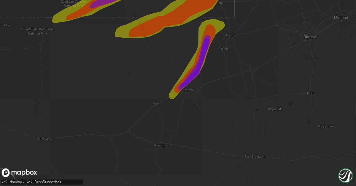
Hail Map in Pecos, TX on March 12, 2019
Get this storm
March 12 map
$229
one time, instant access
Download today. No call, no setup
Keep the $229
Bought the map and want the full workflow? Apply the entire $229 to a subscription within 7 days. None of it is wasted.
Every map, not just this one
This buys you this map. Subscription and you get every map we run, in the markets you choose from a few cities to whole states to nationwide. Plus real-time alerts the moment a storm fires.
Contact data
Name, contact info, occupancy, even credit band for addresses in the footprint. You go from where it hit to who to call.
Become the source they trust
Unlimited branding weather history reports on demand. You already have the documented answer ready for the property owner, and you are the one who showed up with it.
Property data and RoofTrace estimates
Pull up any address you have got, its value and the exact code rules for that jurisdiction, straight from One Click Code. Then RoofTrace estimates the squares, pitch, and roof value, priced the way you price.
Storm reports in Pecos, TX
Pecos, TX
| Date | Description |
|---|---|
| 03/11/20198:35 PM CDT | A local report indicates 59 MPH wind near PECOS |
| 03/11/20198:18 PM CDT | A local report indicates 1.00 inch wind near 23 SSE ORLA |
| 03/11/20198:16 PM CDT | Destroyed vehicle. Est 45 to 50 mph winds |
| 03/11/20198:01 PM CDT | Roof and structural damage approximately one half mile west of pecos airport. Time estimated from radar. |
| 03/11/20197:45 PM CDT | 3.7 n of fm 2119 |
| 03/11/20197:38 PM CDT | A local report indicates 1.00 inch wind near 23 SSE ORLA |
All States Impacted by Hail Map on March 12, 2019
All Cities Impacted by Hail Map on March 12, 2019
- Loving, NM
- Carlsbad, NM
- Salt Flat, TX
- Pecos, TX
- Mentone, TX
- Jal, NM
- Kermit, TX
- Pyote, TX
- Wink, TX
- Barstow, TX
- Fort Sumner, NM
- Lovington, NM
- Hobbs, NM
- Andrews, TX
- Sierra Blanca, TX
- Balmorhea, TX
- Fort Davis, TX
- Fort Stockton, TX
- Dell City, TX
- Marathon, TX
- Imperial, TX
- Comstock, TX
- Dryden, TX
- Coahoma, TX
- Lamesa, TX
- Big Spring, TX
- Alamogordo, NM
- Cloudcroft, NM
- Timberon, NM
- Lenorah, TX
- Stanton, TX
- Ozona, TX
- Welch, TX
- Odonnell, TX
- Tahoka, TX
- Odessa, TX
- Goldsmith, TX
- Van Horn, TX
- Seminole, TX
- Seagraves, TX
- High Rolls Mountain Park, NM
- Ira, TX
- Westbrook, TX
- Kanopolis, KS
- Ellsworth, KS
- Ellinwood, KS
- Claflin, KS
- Eunice, NM
- Sonora, TX
- Beverly, KS
- Holyrood, KS
- Stillwater, OK
- Gail, TX
- Artesia, NM
- Oberlin, KS
- San Angelo, TX
- Minneapolis, KS
- Beloit, KS
- Pinon, NM
- Menard, TX
- London, TX
- Concordia, KS
- Monahans, TX
- Sacramento, NM
- Lake Arthur, NM
- Kendall, KS
- Lincoln, KS
- Eldorado, TX
- Lorraine, KS
- Fort Hancock, TX
- Agenda, KS
- Belleville, KS
- Junction, TX
- Colorado City, TX


