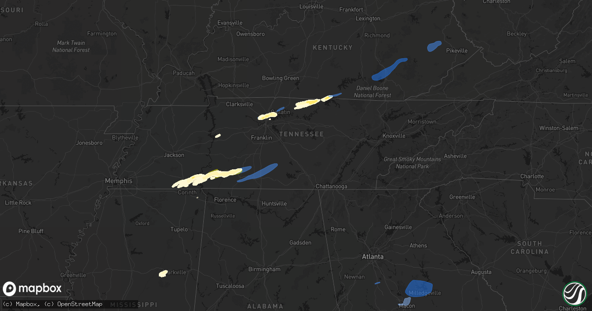
Hail Map in Tennessee on March 11, 2026
Get this storm
March 11 map
$229
one time, instant access
Download today. No call, no setup
Keep the $229
Bought the map and want the full workflow? Apply the entire $229 to a subscription within 7 days. None of it is wasted.
Every map, not just this one
This buys you this map. Subscription and you get every map we run, in the markets you choose from a few cities to whole states to nationwide. Plus real-time alerts the moment a storm fires.
Contact data
Name, contact info, occupancy, even credit band for addresses in the footprint. You go from where it hit to who to call.
Become the source they trust
Unlimited branding weather history reports on demand. You already have the documented answer ready for the property owner, and you are the one who showed up with it.
Property data and RoofTrace estimates
Pull up any address you have got, its value and the exact code rules for that jurisdiction, straight from One Click Code. Then RoofTrace estimates the squares, pitch, and roof value, priced the way you price.
Storm reports in Tennessee
Tennessee
| Date | Description |
|---|---|
| 03/11/20266:58 PM CDT | Delayed report: facebook report of downed trees... Powerlines... And a damaged carport in the area of disco loop road and lake court in friendsville. |
| 03/11/20265:30 PM CDT | Several trees down across the county. |
| 03/11/20264:15 PM CDT | A few powerlines downed due to the wind. |
| 03/11/20263:42 PM CDT | A few trees down at chestnut ridge and hwy 231. |
| 03/11/20263:37 PM CDT | Trees uprooted onto a fence on sinking creek road in sw bedford county. Time estimated from radar. |
| 03/11/20263:35 PM CDT | A couple trees down. |
| 03/11/20263:30 PM CDT | Multiple trees snapped and blown over in yard. |
| 03/11/20263:15 PM CDT | A few trees down near i-65 exit 22 cornersville. |
| 03/11/20263:06 PM CDT | Local business lost part of its metal roof... Peeled up in the wind. |
| 03/11/20263:06 PM CDT | A few trees down in hermitage springs. |
| 03/11/20262:58 PM CDT | Powerlines/powerpole reported down on mapleash avenue in columbia. |
| 03/11/20262:40 PM CDT | Emergency manager provided pictures of metal roofing off a barn structure. |
| 03/11/20262:35 PM CDT | A metal roof was peeled off a portion of a metal building. |
| 03/11/20262:23 PM CDT | Local storm spotter reports winds near 60 mph. |
| 03/11/20262:18 PM CDT | A window was shattered at the gallatin civic center. |
| 03/11/20262:15 PM CDT | Powerlines down in eastern wayne county... Near natchez trace. |
| 03/11/20262:07 PM CDT | Road blocked by tree down. |
| 03/11/20262:03 PM CDT | A building in goodletsville lost some roofing material. |
| 03/11/20262:03 PM CDT | Trees down. |
| 03/11/20261:40 PM CDT | A local report indicates 1.00 inch wind near Olive Hill |
| 03/11/20261:25 PM CDT | A local report indicates 1.00 inch wind near 1 S Crump |
| 03/11/202612:58 PM CDT | Billboard damage and tree limbs down. |
| 03/11/202612:51 PM CDT | A local report indicates 1.00 inch wind near Ramer |
All States Impacted by Hail Map on March 11, 2026
Cities Impacted by Hail Map on March 11, 2026
- Fordyce, AR
- Kingsland, AR
- New Edinburg, AR
- Rison, AR
- Pine Bluff, AR
- Huntington, TX
- Etoile, TX
- San Augustine, TX
- Albany, IN
- Anderson, IN
- Muncie, IN
- Gaston, IN
- Eaton, IN
- Dunkirk, IN
- Cicero, IN
- Daleville, IN
- Noblesville, IN
- Frankton, IN
- Yorktown, IN
- Lapel, IN
- Alexandria, IN
- Atlanta, IN
- Pittsboro, IN
- Lizton, IN
- Roachdale, IN
- Brownsburg, IN
- Zionsville, IN
- Carmel, IN
- North Salem, IN
- Lebanon, IN
- Westfield, IN
- Jamestown, IN
- Whitestown, IN
- Portland, IN
- Redkey, IN
- Ridgeville, IN
- West Milton, OH
- Greenville, OH
- Ludlow Falls, OH
- Pitsburg, OH
- Arcanum, OH
- New Madison, OH
- West Manchester, OH
- Laura, OH
- Troy, OH
- Vandalia, OH
- Englewood, OH
- Brookville, OH
- Lewisburg, OH
- Tipp City, OH
- Eldorado, OH
- New Paris, OH
- Minster, OH
- Botkins, OH
- Houston, OH
- Russia, OH
- Sidney, OH
- Jackson Center, OH
- Yorkshire, OH
- Anna, OH
- Fort Loramie, OH
- Ada, OH
- Kirby, OH
- Lakeview, OH
- Harpster, OH
- La Rue, OH
- Bloomville, OH
- Lewistown, OH
- Nevada, OH
- Forest, OH
- McCutchenville, OH
- Morral, OH
- Wapakoneta, OH
- Huntsville, OH
- New Hampshire, OH
- Kenton, OH
- Dunkirk, OH
- Russells Point, OH
- Wharton, OH
- McGuffey, OH
- Carey, OH
- Belle Center, OH
- Alger, OH
- Harrod, OH
- Sycamore, OH
- Upper Sandusky, OH
- Roundhead, OH
- Tiffin, OH
- Dola, OH
- Bucyrus, OH
- Waynesfield, OH
- Willard, OH
- New London, OH
- Wakeman, OH
- New Washington, OH
- Tiro, OH
- Bellevue, OH
- Attica, OH
- Huron, OH
- Greenwich, OH
- North Fairfield, OH
- Plymouth, OH
- Chatfield, OH
- Collins, OH
- Sandusky, OH
- Monroeville, OH
- Milan, OH
- Green Springs, OH
- Norwalk, OH
- Berlin Heights, OH
- Republic, OH
- Castalia, OH
- Amherst, OH
- Oberlin, OH
- Elyria, OH
- Vermilion, OH
- Kipton, OH
- Wellington, OH
- Lorain, OH
- Spencer, OH
- Homerville, OH
- Sullivan, OH
- Lagrange, OH
- Grafton, OH
- Nova, OH
- Lodi, OH
- Litchfield, OH
- West Salem, OH
- Ashland, OH
- Polk, OH
- Shiloh, OH
- Columbia Station, OH
- North Ridgeville, OH
- Olmsted Falls, OH
- Valley City, OH
- Medina, OH
- Strongsville, OH
- North Olmsted, OH
- Avon, OH
- Sheffield Lake, OH
- Linesville, PA
- Hartstown, PA
- Conneaut Lake, PA
- Cambridge Springs, PA
- Conneautville, PA
- Saegertown, PA
- Harmonsburg, PA
- Meadville, PA
- Guys Mills, PA
- Townville, PA
- Jamestown, PA
- Caldwell, OH
- Pocahontas, TN
- Sarahsville, OH
- Selmer, TN
- Ramer, TN
- Waverly, TN
- Chillicothe, OH
- Kingston, OH
- Stantonville, TN
- Guys, TN
- Hurricane Mills, TN
- Adamsville, TN
- Crump, TN
- Michie, TN
- Counce, TN
- Savannah, TN
- Shiloh, TN
- Olivehill, TN
- Collinwood, TN
- Waynesboro, TN
- Lutts, TN
- Burnsville, MS
- Iuka, MS
- Ashland City, TN
- Joelton, TN
- Lawrenceburg, TN
- Goodlettsville, TN
- Nashville, TN
- Whites Creek, TN
- Perryopolis, PA
- Westpoint, TN
- Ethridge, TN
- Hendersonville, TN
- Madison, TN
- Mount Juliet, TN
- Gallatin, TN
- Star Junction, PA
- Vanderbilt, PA
- Leoma, TN
- Loretto, TN
- Penn Run, PA
- Clymer, PA
- Indiana, PA
- Commodore, PA
- Cherry Tree, PA
- Mentcle, PA
- Northern Cambria, PA
- Spangler, PA
- Marsteller, PA
- Nicktown, PA
- Emeigh, PA
- Hastings, PA
- Carrolltown, PA
- Patton, PA
- Saint Boniface, PA
- Flinton, PA
- Fallentimber, PA
- Lafayette, TN
- Hartsville, TN
- Dixon Springs, TN
- Coalport, PA
- Blandburg, PA
- Tyrone, PA
- Philipsburg, PA
- Smithmill, PA
- Red Boiling Springs, TN
- Hunker, PA
- Mount Pleasant, PA
- Tarrs, PA
- Ruffs Dale, PA
- Alverton, PA
- Scottdale, PA
- New Stanton, PA
- Moss, TN
- Whitleyville, TN
- Celina, TN
- Acme, PA
- Greensburg, PA
- Burkesville, KY
- Tompkinsville, KY
- Hestand, KY
- Stahlstown, PA
- Laughlintown, PA
- Ligonier, PA
- Rector, PA
- Boswell, PA
- Latrobe, PA
- Somerset, PA
- Donegal, PA
- Jerome, PA
- Stoystown, PA
- Johnstown, PA
- Jennerstown, PA
- Windber, PA
- Hollsopple, PA
- Davidsville, PA
- Gray, PA
- Jenners, PA
- Seanor, PA
- Cairnbrook, PA
- Central City, PA
- Friedens, PA
- Hooversville, PA
- Acosta, PA
- New Enterprise, PA
- Queen, PA
- New Paris, PA
- Martinsburg, PA
- Alum Bank, PA
- Claysburg, PA
- Imler, PA
- Osterburg, PA
- Roaring Spring, PA
- Woodbury, PA
- Portage, PA
- Sproul, PA
- Hollidaysburg, PA
- Sidman, PA
- Duncansville, PA
- East Freedom, PA
- Daisytown, PA
- Coal Center, PA
- California, PA
- Brownsville, PA
- Grindstone, PA
- Fayette City, PA
- Dawson, PA
- Connellsville, PA
- Everson, PA
- White, PA
- Normalville, PA
- Champion, PA
- Melcroft, PA
- Indian Head, PA
- Hidden Valley, PA
- Jones Mills, PA
- Saxton, PA
- Williamsburg, PA
- James Creek, PA
- Loysville, PA
- Blain, PA
- Pulaski, TN
- Landisburg, PA
- New Bloomfield, PA
- Shermans Dale, PA
- Elliottsburg, PA
- Duncannon, PA
- Dauphin, PA
- Harrisburg, PA
- Grantville, PA
- Alexandria, LA
- Lecompte, LA
- Starkville, MS
- Maben, MS
- Sturgis, MS
- Ackerman, MS
- Mathiston, MS
- Marksville, LA
- Effie, LA
- Frederick, MD
- Thurmont, MD
- Walkersville, MD
- Woodsboro, MD
- Keymar, MD
- Union Bridge, MD
- New Windsor, MD
- Westminster, MD
- Damascus, MD
- Gaithersburg, MD
- Mount Airy, MD
- Sealy, TX
- Cat Spring, TX
- Brookeville, MD
- Glenelg, MD
- Glenwood, MD
- Woodbine, MD
- West Friendship, MD
- Cooksville, MD
- Ellicott City, MD
- Dayton, MD
- Sykesville, MD
- Marriottsville, MD
- Woodstock, MD
- Windsor Mill, MD
- Randallstown, MD
- Pikesville, MD
- Baltimore, MD
- Gwynn Oak, MD
- Owings Mills, MD
- Lutherville Timonium, MD
- Towson, MD
- Stevenson, MD
- Reisterstown, MD
- Hunt Valley, MD
- Cockeysville, MD
- Glen Arm, MD
- Sparks Glencoe, MD
- Phoenix, MD
- Baldwin, MD
- Hydes, MD
- Monkton, MD
- Fallston, MD
- Jackson, KY
- Clayhole, KY
- Vest, KY
- Gunlock, KY
- Salyersville, KY
- Franklin, TX
- Marquez, TX
- David, KY
- Blue River, KY
- Prestonsburg, KY
- South Fork, PA
- Saint Michael, PA
- Salix, PA
- Elton, PA
- Beaverdale, PA
- Buffalo, TX
- El Campo, TX
- Garwood, TX
- Waynesburg, PA
- Sycamore, PA
- Jefferson, PA
- Mather, PA
- Carmichaels, PA
- Clarksville, PA
- Rices Landing, PA
- Adah, PA
- East Millsboro, PA
- Crucible, PA
- McClellandtown, PA
- New Salem, PA
- Fairbank, PA
- Uniontown, PA
- Smock, PA
- Waltersburg, PA
- Keisterville, PA
- Dunbar, PA
- West Leisenring, PA
- Lemont Furnace, PA
- Mount Braddock, PA
- Youngwood, PA
- Centerville, TX
- Normangee, TX
- Middletown, DE
- Townsend, DE
- Odessa, DE
- Smithdale, MS
- Liberty, MS
- Monterey, LA
- Woodville, MS
- Vidalia, LA
- Amite, LA
- Roseland, LA
- Fluker, LA
- Kentwood, LA
- Mount Hermon, LA
- Independence, LA
- Greensburg, LA
- Holden, LA
- Franklinton, LA
- Loranger, LA
- Folsom, LA
- Covington, LA
- Bush, LA
- Ellisville, MS
- Seminary, MS
- Soso, MS
- Laurel, MS
- Ovett, MS
- Heidelberg, MS
- Shubuta, MS
- Pearl River, LA
- Wiggins, MS
- Brooklyn, MS
- Perkinston, MS
- Beaumont, MS
- McLain, MS
- Neely, MS
- Leakesville, MS
- Lucedale, MS
- Citronelle, AL
- Vinegar Bend, AL
- Tibbie, AL
- Deer Park, AL
- McIntosh, AL
- Chunchula, AL
- Wilmer, AL
- Mount Vernon, AL
- Rockford, AL
- Weogufka, AL
- Frisco City, AL
- Jackson, AL
- Uriah, AL
- Little River, AL
- Wagarville, AL
- Atmore, AL
- Repton, AL
- Brewton, AL
- Monroeville, AL
- Stockton, AL
- Perdido, AL
- Range, AL
- Lenox, AL
- Castleberry, AL
- Gainestown, AL
- Evergreen, AL
- Red Level, AL
- McKenzie, AL
- Dozier, AL
- Brantley, AL
- Church Point, LA
- Goshen, AL
- Glenwood, AL
- Troy, AL
- Banks, AL
- Brundidge, AL
- Louisville, AL
- Clayton, AL
- Midway, AL
- Abbeville, AL
- Headland, AL
- Dothan, AL
- Ashford, AL
- Cottonwood, AL
- Pansey, AL
- Bainbridge, GA
- Climax, GA
- Marshallville, GA
- Fort Valley, GA
- Warner Robins, GA
- Whigham, GA
- Cairo, GA
- Brinson, GA
- Ochlocknee, GA
- Iron City, GA
- Donalsonville, GA
- Thomasville, GA
- Boston, GA
- Camilla, GA
- Attapulgus, GA
- Colquitt, GA
- Meigs, GA
- Pelham, GA
- Chula, GA
- Norman Park, GA
- Lenox, GA
- Enigma, GA
- Ty Ty, GA
- Ocilla, GA
- Adel, GA
- Tifton, GA
- Omega, GA
- Wray, GA
- Alapaha, GA
- Sparks, GA
- Sumner, GA
- Nashville, GA
- Ashburn, GA
- Fitzgerald, GA
- Douglas, GA
- Willacoochee, GA
- Ambrose, GA
- Dixie, GA
- Quitman, GA
- Macon, GA
- Gray, GA
- Eatonton, GA
- Sparta, GA
- Haddock, GA
- Milledgeville, GA
- Hillsboro, GA
- Monticello, GA
- Doerun, GA
- Albany, GA
- Sylvester, GA
- Poulan, GA
- Pearson, GA
- Williamstown, NJ
- New Castle, DE
- Elkton, MD
- Pitman, NJ
- Blackwood, NJ
- Newark, DE
- Sewell, NJ
- Sicklerville, NJ
- Salem, NJ
- Glassboro, NJ
- Swedesboro, NJ
- Mullica Hill, NJ
- Woodstown, NJ
- Pennsville, NJ
- Penns Grove, NJ
- Monroeville, NJ
- Bear, DE
- Elmer, NJ
- Malaga, NJ
- Bridgeton, NJ
- Vineland, NJ
- Newfield, NJ
- Franklinville, NJ
- North East, MD
- Elk Mills, MD
- Pedricktown, NJ
- Charles Town, WV
- Summit Point, WV
- Winchester, VA
- Berryville, VA
- Boyce, VA
- Clarksburg, MD
- Ijamsville, MD
- Dickerson, MD
- Boyds, MD
- Germantown, MD
- Ingalls, IN
- Markleville, IN
- Indianapolis, IN
- Middletown, IN
- Fishers, IN
- Springport, IN
- Shirley, IN
- Pendleton, IN
- Fortville, IN
- Mccordsville, IN
- Nineveh, IN
- Edinburgh, IN
- Franklin, IN
- Winchester, IN
- Salamonia, IN
- Selma, IN
- Versailles, OH
- Rossburg, OH
- Farmland, IN
- New Weston, OH
- Coldwater, OH
- Saint Henry, OH
- Saratoga, IN
- Fort Recovery, OH
- Montezuma, OH
- Osgood, OH
- Burkettsville, OH
- Ansonia, OH
- Union City, IN
- Union City, OH
- Celina, OH
- Maria Stein, OH
- Parker City, IN
- Chickasaw, OH
- New Knoxville, OH
- Clyde, OH
- New Bremen, OH
- Eaton, OH
- Connersville, IN
- Richmond, IN
- Greens Fork, IN
- Boston, IN
- Cambridge City, IN
- Brownsville, IN
- Milton, IN
- Glenwood, IN
- Rushville, IN
- Centerville, IN
- Falmouth, IN
- Liberty, IN
- Ariton, AL
- Ozark, AL
- Skipperville, AL
- Clopton, AL
- Webb, AL
- Freeport, FL
- Ponce De Leon, FL
- Vernon, FL
- Ebro, FL
- Panama City Beach, FL
- Panama City, FL
- Lynn Haven, FL
- Griffin, GA
- Columbia, AL
- Blakely, GA
- Damascus, GA
- Box Springs, GA
- Mauk, GA
- Clinton, LA
- Greenwell Springs, LA
- Mandeville, LA
- Ponchatoula, LA
- Slidell, LA
- Perry, GA
- Oglethorpe, GA
- Kathleen, GA
- Bonaire, GA
- Bluffton, IN
- Tickfaw, LA
- Hammond, LA
- Albany, LA
- Ruth, MS
- Bogue Chitto, MS
- Jayess, MS
- Carson, MS
- Oak Vale, MS
- Bassfield, MS
- Sumrall, MS
- Kiln, MS
- Lacombe, LA
- Gulfport, MS
- Pass Christian, MS
- Bay Saint Louis, MS
- New Orleans, LA
- Long Beach, MS
- Waveland, MS
- Diamondhead, MS
- Biloxi, MS
- Pearlington, MS
- Lynnville, TN
- Summertown, TN
- Petersburg, TN
- Shelbyville, TN
- Cornersville, TN
- Lewisburg, TN
- Belfast, TN
- Old Hickory, TN
- Bethpage, TN
- Albany, KY
- Oneida, KY
- Keavy, KY
- Somerset, KY
- Manchester, KY
- London, KY
- Sextons Creek, KY
- Annville, KY
- Corbin, KY
- Lily, KY
- Parkers Lake, KY
- Columbus, GA
- Phenix City, AL
- Smiths Station, AL
- Pinehurst, GA
- Unadilla, GA
- Silas, AL
- Summit, MS
- Mccomb, MS


