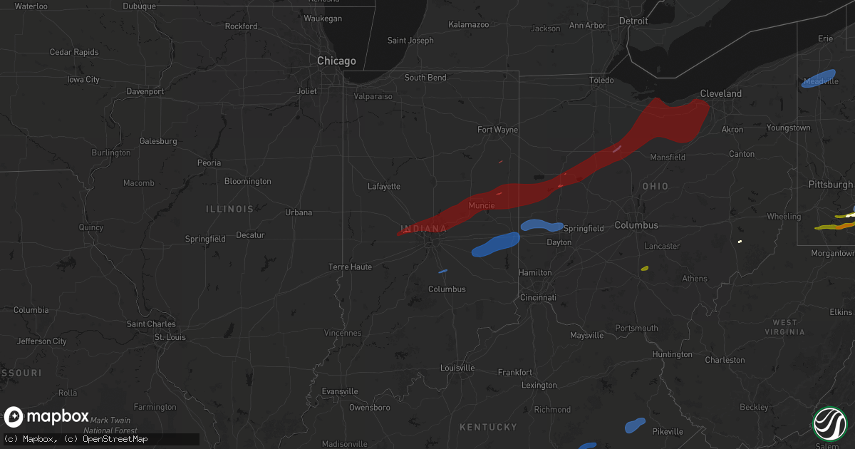
Hail Map in Indiana on March 11, 2026
Get this storm
March 11 map
$229
one time, instant access
Download today. No call, no setup
Keep the $229
Bought the map and want the full workflow? Apply the entire $229 to a subscription within 7 days. None of it is wasted.
Every map, not just this one
This buys you this map. Subscription and you get every map we run, in the markets you choose from a few cities to whole states to nationwide. Plus real-time alerts the moment a storm fires.
Contact data
Name, contact info, occupancy, even credit band for addresses in the footprint. You go from where it hit to who to call.
Become the source they trust
Unlimited branding weather history reports on demand. You already have the documented answer ready for the property owner, and you are the one who showed up with it.
Property data and RoofTrace estimates
Pull up any address you have got, its value and the exact code rules for that jurisdiction, straight from One Click Code. Then RoofTrace estimates the squares, pitch, and roof value, priced the way you price.
Storm reports in Indiana
Indiana
| Date | Description |
|---|---|
| 03/11/202610:31 AM CDT | Video of damaging wind gusts estimated around 70mph. |
| 03/11/20268:51 AM CDT | Several trees and power poles and wires down. Time estimated from radar. |
| 03/11/20268:44 AM CDT | Roof blown off building on south 8th street. Time estimated from radar. |
| 03/11/20268:43 AM CDT | Damage to roof and ac unit and union city jr/sr high school. |
| 03/11/20268:42 AM CDT | Covered bridge at harter park collapsed. |
| 03/11/20268:38 AM CDT | 4300 block of county road 850 w. Just north of falmouth in. Forwarded a public report. Damage to pole barn... Bulk seed bins moved... Siding off several buildings... 3 |
| 03/11/20268:36 AM CDT | Trees and power lines down at 400 e and ornge pike. |
| 03/11/20268:27 AM CDT | Power pole broken. |
| 03/11/20268:27 AM CDT | Power pole down on meridian street. |
| 03/11/20268:19 AM CDT | 1 foot diameter tree down... Blocking roadway... Power lines involved. |
| 03/11/20268:18 AM CDT | Damage to the roof of a barn but siding remains intact. Roofing appears to be a combination of metal panels and wood 2x4s. Time estimated by radar. |
| 03/11/20268:16 AM CDT | Multiple trees down - blocking roadway - power lines involved. |
| 03/11/20268:05 AM CDT | Delayed report. A semi was flipped on its side by thunderstorm winds on i-65 at mile marker 83.5. Time estimated from radar. |
| 03/11/20268:00 AM CDT | A local report indicates 58 MPH wind near Yorktown |
| 03/11/20267:59 AM CDT | Power pole broken across the roadway. |
| 03/11/20267:58 AM CDT | Multiple trees and power lines down. Damage to a pole barn. |
| 03/11/20267:55 AM CDT | Delayed report. Time estimated from radar. Considerable lightly scattered debris from an old barn and possibly a shed in a yard and agricultural field between 900 w and |
| 03/11/20267:55 AM CDT | Delayed report. Time estimated from radar. Scattered healthy pine trees approximately 2 feet in diameter were snapped off 10 feet or more above the ground. |
| 03/11/20267:55 AM CDT | Delayed report. Time estimated from radar. Thunderstorm winds caused tree damage and roof damage to pole barn in and across from 1460 s 900 w daleville indiana. |
| 03/11/20267:50 AM CDT | A local report indicates 58 MPH wind near 2 S Linwood |
| 03/11/20267:49 AM CDT | Many reports of large limbs down. |
| 03/11/20267:48 AM CDT | Several trees and poles down blocking roads south of anderson near pendleton. Structural damage to roofs of houses. Time estimated by radar. |
| 03/11/20267:45 AM CDT | Some tree limbs down. |
| 03/11/20267:39 AM CDT | Large tree toppled onto house. |
| 03/11/20267:34 AM CDT | Corrects previous tstm wnd dmg report from koleen. Thunderstorm wind damage to a tree. |
| 03/11/20267:32 AM CDT | Southbound lanes of sr 37 blocked by a large tree limb at promise road. |
| 03/11/20267:28 AM CDT | Garage door blown in. Time estimated from radar. |
| 03/11/20267:27 AM CDT | Trees down along allisonville from 71st to 75th. Time estimated from radar. |
| 03/11/20267:25 AM CDT | Power lines down. Time estimated from radar. |
| 03/11/20267:19 AM CDT | A local report indicates 68 MPH wind near 1 N Zionsville |
| 03/11/20267:17 AM CDT | Thunderstorm winds blew down trees. |
| 03/11/20267:07 AM CDT | Corrects previous tstm wnd dmg report from linton. Thunderstorm wind damage to a roof and billboard. |
| 03/11/20267:00 AM CDT | Corrects previous tstm wnd dmg report from 1 sse lizton. Tree down on sr 136 near entrance to tri west middle school. Long section of chain link fence torn off its supp |
| 03/11/20267:00 AM CDT | Tree down on sr 136 near entrance to tri west middle school. Some shingles off home across the street. Trees and branches down in and around the school parking lot. Tim |
| 03/10/20267:34 PM CDT | Thunderstorm wind damage to a tree. |
| 03/10/20267:07 PM CDT | Thunderstorm wind damage to a roof and billboard. |
All States Impacted by Hail Map on March 11, 2026
Cities Impacted by Hail Map on March 11, 2026
- Fordyce, AR
- Kingsland, AR
- New Edinburg, AR
- Rison, AR
- Pine Bluff, AR
- Huntington, TX
- Etoile, TX
- San Augustine, TX
- Albany, IN
- Anderson, IN
- Muncie, IN
- Gaston, IN
- Eaton, IN
- Dunkirk, IN
- Cicero, IN
- Daleville, IN
- Noblesville, IN
- Frankton, IN
- Yorktown, IN
- Lapel, IN
- Alexandria, IN
- Atlanta, IN
- Pittsboro, IN
- Lizton, IN
- Roachdale, IN
- Brownsburg, IN
- Zionsville, IN
- Carmel, IN
- North Salem, IN
- Lebanon, IN
- Westfield, IN
- Jamestown, IN
- Whitestown, IN
- Portland, IN
- Redkey, IN
- Ridgeville, IN
- West Milton, OH
- Greenville, OH
- Ludlow Falls, OH
- Pitsburg, OH
- Arcanum, OH
- New Madison, OH
- West Manchester, OH
- Laura, OH
- Troy, OH
- Vandalia, OH
- Englewood, OH
- Brookville, OH
- Lewisburg, OH
- Tipp City, OH
- Eldorado, OH
- New Paris, OH
- Minster, OH
- Botkins, OH
- Houston, OH
- Russia, OH
- Sidney, OH
- Jackson Center, OH
- Yorkshire, OH
- Anna, OH
- Fort Loramie, OH
- Ada, OH
- Kirby, OH
- Lakeview, OH
- Harpster, OH
- La Rue, OH
- Bloomville, OH
- Lewistown, OH
- Nevada, OH
- Forest, OH
- McCutchenville, OH
- Morral, OH
- Wapakoneta, OH
- Huntsville, OH
- New Hampshire, OH
- Kenton, OH
- Dunkirk, OH
- Russells Point, OH
- Wharton, OH
- McGuffey, OH
- Carey, OH
- Belle Center, OH
- Alger, OH
- Harrod, OH
- Sycamore, OH
- Upper Sandusky, OH
- Roundhead, OH
- Tiffin, OH
- Dola, OH
- Bucyrus, OH
- Waynesfield, OH
- Willard, OH
- New London, OH
- Wakeman, OH
- New Washington, OH
- Tiro, OH
- Bellevue, OH
- Attica, OH
- Huron, OH
- Greenwich, OH
- North Fairfield, OH
- Plymouth, OH
- Chatfield, OH
- Collins, OH
- Sandusky, OH
- Monroeville, OH
- Milan, OH
- Green Springs, OH
- Norwalk, OH
- Berlin Heights, OH
- Republic, OH
- Castalia, OH
- Amherst, OH
- Oberlin, OH
- Elyria, OH
- Vermilion, OH
- Kipton, OH
- Wellington, OH
- Lorain, OH
- Spencer, OH
- Homerville, OH
- Sullivan, OH
- Lagrange, OH
- Grafton, OH
- Nova, OH
- Lodi, OH
- Litchfield, OH
- West Salem, OH
- Ashland, OH
- Polk, OH
- Shiloh, OH
- Columbia Station, OH
- North Ridgeville, OH
- Olmsted Falls, OH
- Valley City, OH
- Medina, OH
- Strongsville, OH
- North Olmsted, OH
- Avon, OH
- Sheffield Lake, OH
- Linesville, PA
- Hartstown, PA
- Conneaut Lake, PA
- Cambridge Springs, PA
- Conneautville, PA
- Saegertown, PA
- Harmonsburg, PA
- Meadville, PA
- Guys Mills, PA
- Townville, PA
- Jamestown, PA
- Caldwell, OH
- Pocahontas, TN
- Sarahsville, OH
- Selmer, TN
- Ramer, TN
- Waverly, TN
- Chillicothe, OH
- Kingston, OH
- Stantonville, TN
- Guys, TN
- Hurricane Mills, TN
- Adamsville, TN
- Crump, TN
- Michie, TN
- Counce, TN
- Savannah, TN
- Shiloh, TN
- Olivehill, TN
- Collinwood, TN
- Waynesboro, TN
- Lutts, TN
- Burnsville, MS
- Iuka, MS
- Ashland City, TN
- Joelton, TN
- Lawrenceburg, TN
- Goodlettsville, TN
- Nashville, TN
- Whites Creek, TN
- Perryopolis, PA
- Westpoint, TN
- Ethridge, TN
- Hendersonville, TN
- Madison, TN
- Mount Juliet, TN
- Gallatin, TN
- Star Junction, PA
- Vanderbilt, PA
- Leoma, TN
- Loretto, TN
- Penn Run, PA
- Clymer, PA
- Indiana, PA
- Commodore, PA
- Cherry Tree, PA
- Mentcle, PA
- Northern Cambria, PA
- Spangler, PA
- Marsteller, PA
- Nicktown, PA
- Emeigh, PA
- Hastings, PA
- Carrolltown, PA
- Patton, PA
- Saint Boniface, PA
- Flinton, PA
- Fallentimber, PA
- Lafayette, TN
- Hartsville, TN
- Dixon Springs, TN
- Coalport, PA
- Blandburg, PA
- Tyrone, PA
- Philipsburg, PA
- Smithmill, PA
- Red Boiling Springs, TN
- Hunker, PA
- Mount Pleasant, PA
- Tarrs, PA
- Ruffs Dale, PA
- Alverton, PA
- Scottdale, PA
- New Stanton, PA
- Moss, TN
- Whitleyville, TN
- Celina, TN
- Acme, PA
- Greensburg, PA
- Burkesville, KY
- Tompkinsville, KY
- Hestand, KY
- Stahlstown, PA
- Laughlintown, PA
- Ligonier, PA
- Rector, PA
- Boswell, PA
- Latrobe, PA
- Somerset, PA
- Donegal, PA
- Jerome, PA
- Stoystown, PA
- Johnstown, PA
- Jennerstown, PA
- Windber, PA
- Hollsopple, PA
- Davidsville, PA
- Gray, PA
- Jenners, PA
- Seanor, PA
- Cairnbrook, PA
- Central City, PA
- Friedens, PA
- Hooversville, PA
- Acosta, PA
- New Enterprise, PA
- Queen, PA
- New Paris, PA
- Martinsburg, PA
- Alum Bank, PA
- Claysburg, PA
- Imler, PA
- Osterburg, PA
- Roaring Spring, PA
- Woodbury, PA
- Portage, PA
- Sproul, PA
- Hollidaysburg, PA
- Sidman, PA
- Duncansville, PA
- East Freedom, PA
- Daisytown, PA
- Coal Center, PA
- California, PA
- Brownsville, PA
- Grindstone, PA
- Fayette City, PA
- Dawson, PA
- Connellsville, PA
- Everson, PA
- White, PA
- Normalville, PA
- Champion, PA
- Melcroft, PA
- Indian Head, PA
- Hidden Valley, PA
- Jones Mills, PA
- Saxton, PA
- Williamsburg, PA
- James Creek, PA
- Loysville, PA
- Blain, PA
- Pulaski, TN
- Landisburg, PA
- New Bloomfield, PA
- Shermans Dale, PA
- Elliottsburg, PA
- Duncannon, PA
- Dauphin, PA
- Harrisburg, PA
- Grantville, PA
- Alexandria, LA
- Lecompte, LA
- Starkville, MS
- Maben, MS
- Sturgis, MS
- Ackerman, MS
- Mathiston, MS
- Marksville, LA
- Effie, LA
- Frederick, MD
- Thurmont, MD
- Walkersville, MD
- Woodsboro, MD
- Keymar, MD
- Union Bridge, MD
- New Windsor, MD
- Westminster, MD
- Damascus, MD
- Gaithersburg, MD
- Mount Airy, MD
- Sealy, TX
- Cat Spring, TX
- Brookeville, MD
- Glenelg, MD
- Glenwood, MD
- Woodbine, MD
- West Friendship, MD
- Cooksville, MD
- Ellicott City, MD
- Dayton, MD
- Sykesville, MD
- Marriottsville, MD
- Woodstock, MD
- Windsor Mill, MD
- Randallstown, MD
- Pikesville, MD
- Baltimore, MD
- Gwynn Oak, MD
- Owings Mills, MD
- Lutherville Timonium, MD
- Towson, MD
- Stevenson, MD
- Reisterstown, MD
- Hunt Valley, MD
- Cockeysville, MD
- Glen Arm, MD
- Sparks Glencoe, MD
- Phoenix, MD
- Baldwin, MD
- Hydes, MD
- Monkton, MD
- Fallston, MD
- Jackson, KY
- Clayhole, KY
- Vest, KY
- Gunlock, KY
- Salyersville, KY
- Franklin, TX
- Marquez, TX
- David, KY
- Blue River, KY
- Prestonsburg, KY
- South Fork, PA
- Saint Michael, PA
- Salix, PA
- Elton, PA
- Beaverdale, PA
- Buffalo, TX
- El Campo, TX
- Garwood, TX
- Waynesburg, PA
- Sycamore, PA
- Jefferson, PA
- Mather, PA
- Carmichaels, PA
- Clarksville, PA
- Rices Landing, PA
- Adah, PA
- East Millsboro, PA
- Crucible, PA
- McClellandtown, PA
- New Salem, PA
- Fairbank, PA
- Uniontown, PA
- Smock, PA
- Waltersburg, PA
- Keisterville, PA
- Dunbar, PA
- West Leisenring, PA
- Lemont Furnace, PA
- Mount Braddock, PA
- Youngwood, PA
- Centerville, TX
- Normangee, TX
- Middletown, DE
- Townsend, DE
- Odessa, DE
- Smithdale, MS
- Liberty, MS
- Monterey, LA
- Woodville, MS
- Vidalia, LA
- Amite, LA
- Roseland, LA
- Fluker, LA
- Kentwood, LA
- Mount Hermon, LA
- Independence, LA
- Greensburg, LA
- Holden, LA
- Franklinton, LA
- Loranger, LA
- Folsom, LA
- Covington, LA
- Bush, LA
- Ellisville, MS
- Seminary, MS
- Soso, MS
- Laurel, MS
- Ovett, MS
- Heidelberg, MS
- Shubuta, MS
- Pearl River, LA
- Wiggins, MS
- Brooklyn, MS
- Perkinston, MS
- Beaumont, MS
- McLain, MS
- Neely, MS
- Leakesville, MS
- Lucedale, MS
- Citronelle, AL
- Vinegar Bend, AL
- Tibbie, AL
- Deer Park, AL
- McIntosh, AL
- Chunchula, AL
- Wilmer, AL
- Mount Vernon, AL
- Rockford, AL
- Weogufka, AL
- Frisco City, AL
- Jackson, AL
- Uriah, AL
- Little River, AL
- Wagarville, AL
- Atmore, AL
- Repton, AL
- Brewton, AL
- Monroeville, AL
- Stockton, AL
- Perdido, AL
- Range, AL
- Lenox, AL
- Castleberry, AL
- Gainestown, AL
- Evergreen, AL
- Red Level, AL
- McKenzie, AL
- Dozier, AL
- Brantley, AL
- Church Point, LA
- Goshen, AL
- Glenwood, AL
- Troy, AL
- Banks, AL
- Brundidge, AL
- Louisville, AL
- Clayton, AL
- Midway, AL
- Abbeville, AL
- Headland, AL
- Dothan, AL
- Ashford, AL
- Cottonwood, AL
- Pansey, AL
- Bainbridge, GA
- Climax, GA
- Marshallville, GA
- Fort Valley, GA
- Warner Robins, GA
- Whigham, GA
- Cairo, GA
- Brinson, GA
- Ochlocknee, GA
- Iron City, GA
- Donalsonville, GA
- Thomasville, GA
- Boston, GA
- Camilla, GA
- Attapulgus, GA
- Colquitt, GA
- Meigs, GA
- Pelham, GA
- Chula, GA
- Norman Park, GA
- Lenox, GA
- Enigma, GA
- Ty Ty, GA
- Ocilla, GA
- Adel, GA
- Tifton, GA
- Omega, GA
- Wray, GA
- Alapaha, GA
- Sparks, GA
- Sumner, GA
- Nashville, GA
- Ashburn, GA
- Fitzgerald, GA
- Douglas, GA
- Willacoochee, GA
- Ambrose, GA
- Dixie, GA
- Quitman, GA
- Macon, GA
- Gray, GA
- Eatonton, GA
- Sparta, GA
- Haddock, GA
- Milledgeville, GA
- Hillsboro, GA
- Monticello, GA
- Doerun, GA
- Albany, GA
- Sylvester, GA
- Poulan, GA
- Pearson, GA
- Williamstown, NJ
- New Castle, DE
- Elkton, MD
- Pitman, NJ
- Blackwood, NJ
- Newark, DE
- Sewell, NJ
- Sicklerville, NJ
- Salem, NJ
- Glassboro, NJ
- Swedesboro, NJ
- Mullica Hill, NJ
- Woodstown, NJ
- Pennsville, NJ
- Penns Grove, NJ
- Monroeville, NJ
- Bear, DE
- Elmer, NJ
- Malaga, NJ
- Bridgeton, NJ
- Vineland, NJ
- Newfield, NJ
- Franklinville, NJ
- North East, MD
- Elk Mills, MD
- Pedricktown, NJ
- Charles Town, WV
- Summit Point, WV
- Winchester, VA
- Berryville, VA
- Boyce, VA
- Clarksburg, MD
- Ijamsville, MD
- Dickerson, MD
- Boyds, MD
- Germantown, MD
- Ingalls, IN
- Markleville, IN
- Indianapolis, IN
- Middletown, IN
- Fishers, IN
- Springport, IN
- Shirley, IN
- Pendleton, IN
- Fortville, IN
- Mccordsville, IN
- Nineveh, IN
- Edinburgh, IN
- Franklin, IN
- Winchester, IN
- Salamonia, IN
- Selma, IN
- Versailles, OH
- Rossburg, OH
- Farmland, IN
- New Weston, OH
- Coldwater, OH
- Saint Henry, OH
- Saratoga, IN
- Fort Recovery, OH
- Montezuma, OH
- Osgood, OH
- Burkettsville, OH
- Ansonia, OH
- Union City, IN
- Union City, OH
- Celina, OH
- Maria Stein, OH
- Parker City, IN
- Chickasaw, OH
- New Knoxville, OH
- Clyde, OH
- New Bremen, OH
- Eaton, OH
- Connersville, IN
- Richmond, IN
- Greens Fork, IN
- Boston, IN
- Cambridge City, IN
- Brownsville, IN
- Milton, IN
- Glenwood, IN
- Rushville, IN
- Centerville, IN
- Falmouth, IN
- Liberty, IN
- Ariton, AL
- Ozark, AL
- Skipperville, AL
- Clopton, AL
- Webb, AL
- Freeport, FL
- Ponce De Leon, FL
- Vernon, FL
- Ebro, FL
- Panama City Beach, FL
- Panama City, FL
- Lynn Haven, FL
- Griffin, GA
- Columbia, AL
- Blakely, GA
- Damascus, GA
- Box Springs, GA
- Mauk, GA
- Clinton, LA
- Greenwell Springs, LA
- Mandeville, LA
- Ponchatoula, LA
- Slidell, LA
- Perry, GA
- Oglethorpe, GA
- Kathleen, GA
- Bonaire, GA
- Bluffton, IN
- Tickfaw, LA
- Hammond, LA
- Albany, LA
- Ruth, MS
- Bogue Chitto, MS
- Jayess, MS
- Carson, MS
- Oak Vale, MS
- Bassfield, MS
- Sumrall, MS
- Kiln, MS
- Lacombe, LA
- Gulfport, MS
- Pass Christian, MS
- Bay Saint Louis, MS
- New Orleans, LA
- Long Beach, MS
- Waveland, MS
- Diamondhead, MS
- Biloxi, MS
- Pearlington, MS
- Lynnville, TN
- Summertown, TN
- Petersburg, TN
- Shelbyville, TN
- Cornersville, TN
- Lewisburg, TN
- Belfast, TN
- Old Hickory, TN
- Bethpage, TN
- Albany, KY
- Oneida, KY
- Keavy, KY
- Somerset, KY
- Manchester, KY
- London, KY
- Sextons Creek, KY
- Annville, KY
- Corbin, KY
- Lily, KY
- Parkers Lake, KY
- Columbus, GA
- Phenix City, AL
- Smiths Station, AL
- Pinehurst, GA
- Unadilla, GA
- Silas, AL
- Summit, MS
- Mccomb, MS


