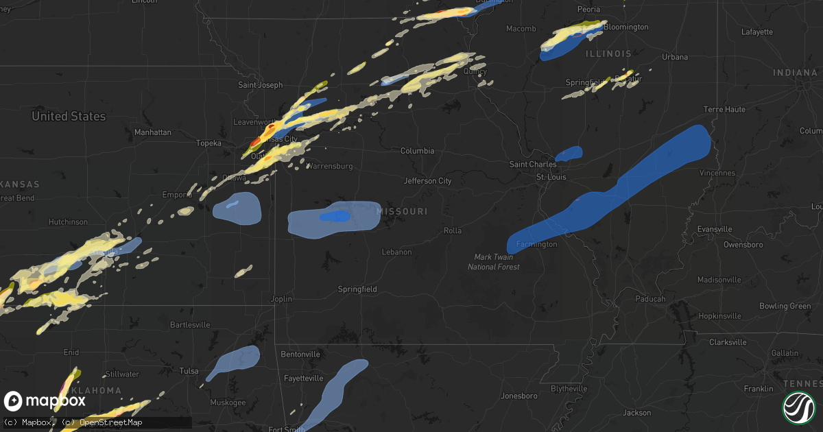
Hail Map in Missouri on March 10, 2026
Get this storm
March 10 map
$229
one time, instant access
Download today. No call, no setup
Keep the $229
Bought the map and want the full workflow? Apply the entire $229 to a subscription within 7 days. None of it is wasted.
Every map, not just this one
This buys you this map. Subscription and you get every map we run, in the markets you choose from a few cities to whole states to nationwide. Plus real-time alerts the moment a storm fires.
Contact data
Name, contact info, occupancy, even credit band for addresses in the footprint. You go from where it hit to who to call.
Become the source they trust
Unlimited branding weather history reports on demand. You already have the documented answer ready for the property owner, and you are the one who showed up with it.
Property data and RoofTrace estimates
Pull up any address you have got, its value and the exact code rules for that jurisdiction, straight from One Click Code. Then RoofTrace estimates the squares, pitch, and roof value, priced the way you price.
Storm reports in Missouri
Missouri
| Date | Description |
|---|---|
| 03/10/20266:59 PM CDT | Report from mping: quarter |
| 03/10/20266:52 PM CDT | Social media report of slightly larger than golf ball size hail near oak trafficway. Time estimated from social media post and confirmed from radar. |
| 03/10/20266:52 PM CDT | Mping reports of tree damage northeast of lake waukomis. Time confirmed from radar. |
| 03/10/20266:51 PM CDT | Report from mping: golf ball |
| 03/10/20266:50 PM CDT | Social media report of quarter size hail near kearney. Time estimated from radar. |
| 03/10/20266:48 PM CDT | Report from mping: half dollar |
| 03/10/20266:45 PM CDT | Report from mping: ping pong ball |
| 03/10/20266:40 PM CDT | Social media report of downed trees and damage to a property near routes 152 and 169. Golf ball size hail also reported with the storm. Time confirmed from radar. |
| 03/10/20266:40 PM CDT | Report from mping: ping pong ball |
| 03/10/20266:39 PM CDT | Report from mping: half dollar |
| 03/10/20266:38 PM CDT | Report from mping: ping pong ball |
| 03/10/20266:37 PM CDT | Report from mping: baseball++ |
| 03/10/20266:37 PM CDT | Report from mping: tennis ball |
| 03/10/20266:36 PM CDT | Report from mping: quarter |
| 03/10/20266:36 PM CDT | Public relayed images of up to around ping pong ball size hail via social media. |
| 03/10/20266:36 PM CDT | Report from mping: ping pong ball |
| 03/10/20266:36 PM CDT | Social media report and photo. Time estimated from radar. |
| 03/10/20266:35 PM CDT | Report from mping: hen egg |
| 03/10/20266:35 PM CDT | Public relayed picture of hail... Via social media... Estimated to be just larger than golf balls. |
| 03/10/20266:35 PM CDT | Report from mping: hen egg |
| 03/10/20266:34 PM CDT | Report from mping: baseball |
| 03/10/20266:34 PM CDT | Report from mping: ping pong ball |
| 03/10/20266:33 PM CDT | Broadcast media shared photos of tennis ball hail... With statement of several baseball size stones seen. |
| 03/10/20266:32 PM CDT | Spotter relayed report of hail up to just bigger than tennis balls. |
| 03/10/20266:32 PM CDT | Report from mping: quarter |
| 03/10/20266:31 PM CDT | Report from mping: golf ball |
| 03/10/20266:30 PM CDT | Report from mping: half dollar |
| 03/10/20266:30 PM CDT | Public reported quarter hail. |
| 03/10/20266:30 PM CDT | Public relayed images of very large hail via social media. Estimated up to baseball in size. |
| 03/10/20266:30 PM CDT | A local report indicates 2.75 inch wind near 1 NW Houston Lake |
| 03/10/20266:30 PM CDT | Public relayed hail compared to a quarter... Via social media. Estimated up to just larger than 2 inches. |
| 03/10/20266:30 PM CDT | A local report indicates 3.00 inch wind near 2 SE Weatherby Lake |
| 03/10/20266:30 PM CDT | Retired nws employee reported golf ball to orange hai. |
| 03/10/20266:29 PM CDT | Social media report with photo and measurement. Time estimated from radar. |
| 03/10/20266:29 PM CDT | Social media report and photo. Time estimated from radar. |
| 03/10/20266:29 PM CDT | Social media photo and size estimate. Time based on radar. |
| 03/10/20266:29 PM CDT | Report from mping: hen egg |
| 03/10/20266:29 PM CDT | Public relayed images of large hail... Estimated to around tennis ball. |
| 03/10/20266:28 PM CDT | Nws employee relayed picture of up to 3.25 inch hail at parents house. |
| 03/10/20266:25 PM CDT | Multiple cracked or broken windshields. Time confirmed from radar. |
| 03/10/20264:50 AM CDT | Tree damage. Time estimated by radar. |
| 03/10/20264:20 AM CDT | Tree down on house in leadwood. |
| 03/10/20263:30 AM CDT | 3 power poles broken. Time estimated by radar. |
| 03/10/20263:26 AM CDT | Metal sheet roofing removed from an outbuilding at an animal rescue. Time estimated from radar. |
| 03/10/20262:47 AM CDT | Corrects previous tstm wnd dmg report from 3 nnw orchard farms. Significant damage to a barn in northwest st. Charles county... Mo. |
| 03/10/20261:21 AM CDT | A tree branch was over the roadway on o highway. Size unknown. |
| 03/10/20261:20 AM CDT | A tree was downed off of south marvin road. |
| 03/10/20261:14 AM CDT | A small shed was blown over in versailles. |
| 03/10/202612:45 AM CDT | A tree was down over the roadway along commercial st and niangua st. |
| 03/10/202612:42 AM CDT | An outbuilding was flipped upside down. |
| 03/10/202612:42 AM CDT | Numerous power poles and power lines are down at highway 83 and highway ee. |
| 03/10/202612:40 AM CDT | A 79mph wind gust was measured at the scout camp near iconium. |
| 03/10/202612:15 AM CDT | N main st... Martin st... N saint james st... Trees and branches down. Shingles... Gutters and trees on the house. Fence blown down at the cemetery. Time based on radar |
| 03/10/202612:15 AM CDT | A nws storm survey found numerous uprooted trees laying in a east to northeast pattern from west of el dorado springs through the north side of el dorado springs. One t |
| 03/10/202612:15 AM CDT | An outbuilding sustained extensive damage with walls falling outward. Maximum winds were estimated at 80mph. |
| 03/09/202611:45 PM CDT | Social media report. Time estimated from radar. |
| 03/09/202611:37 PM CDT | Public report of a downed tree and minor property damage at a residence near rich hill. Time estimated from radar. |
| 03/09/202611:14 PM CDT | Downed tree and minor property damage at a residence southwest of peculiar. Time estimated from radar. |
| 03/09/202610:53 PM CDT | Social media report. Time estimated from radar. |
| 03/09/202610:48 PM CDT | Time confirmed from radar. |
| 03/09/202610:33 PM CDT | Report from mping: quarter |
| 03/09/202610:32 PM CDT | Time confirmed from radar. |
| 03/09/202610:26 PM CDT | A local report indicates 1.00 inch wind near 3 SW Lake Tapawingo |
| 03/09/202610:26 PM CDT | Report from mping: ping pong ball |
| 03/09/202610:26 PM CDT | Time confirmed from radar. |
| 03/09/202610:26 PM CDT | Time estimated from radar. |
| 03/09/202610:13 PM CDT | Report from mping: half dollar |
| 03/09/202610:09 PM CDT | Social media report and photo. Time estimated from radar. |
| 03/09/20269:48 PM CDT | Social media report of quarter size hail between macon and clarence. Time estimated from radar. |
| 03/09/20269:46 PM CDT | Report from mping: quarter |
| 03/09/20269:41 PM CDT | A local report indicates 1.25 inch wind near 2 S Raytown |
| 03/09/20269:40 PM CDT | A local report indicates 1.25 inch wind near 2 SW Raytown |
| 03/09/20269:23 PM CDT | Social media report. Time confirmed from radar. |
| 03/09/20269:20 PM CDT | Downed wires near derstier road. Time estimated from radar. |
| 03/09/20269:15 PM CDT | Social media report. |
| 03/09/20268:34 PM CDT | Private weather sensor. |
| 03/09/20268:09 PM CDT | Social media photo of walnut sized hail east of stet. Time estimated from radar. |
| 03/09/20268:08 PM CDT | A local report indicates 1.50 inch wind near 5 NNE Green Castle |
| 03/09/20267:49 PM CDT | Social media report. Time estimated from radar. |
| 03/09/20267:49 PM CDT | Downed wires near route m. Time estimated from radar. |
| 03/09/20267:46 PM CDT | Downed wires near crowley road. Time confirmed from radar. |
| 03/09/20267:45 PM CDT | Social media photo of quarter size hail in excelsior springs. Time estimated from radar. |
| 03/09/20267:44 PM CDT | Social media report of quarter size hail on route 10 east of woods heights. Time estimated from radar. |
| 03/09/20267:35 PM CDT | Downed tree and wires near 98th street. Time estimated from radar. |
| 03/09/20267:35 PM CDT | Social media report of quarter size hail in wood heights. Time estimated from radar. |
| 03/09/20267:30 PM CDT | Social media report. Time estimated from radar. |
| 03/09/20267:27 PM CDT | Social media report of walnut size hail near mirabile. Time estimated from radar. |
| 03/09/20267:19 PM CDT | Report from mping: golf ball |
| 03/09/20267:17 PM CDT | Social media report of quarter size hail east of hamilton. Time estimated from radar. |
| 03/09/20267:16 PM CDT | Social media report and photos. Time confirmed from radar. |
| 03/09/20267:15 PM CDT | Downed power lines near holstein road. Time estimated from radar. |
| 03/09/20267:07 PM CDT | Report from mping: quarter |
| 03/09/20267:05 PM CDT | Downed wires near shepherd road. Time estimated from radar. |
| 03/09/20267:02 PM CDT | Social media report of half dollar size hail in lawson. Time estimated from radar. |
| 03/09/20267:02 PM CDT | Report from mping: quarter |
| 03/09/20267:00 PM CDT | Up to inch and a half hail reported. |
All States Impacted by Hail Map on March 10, 2026
Cities Impacted by Hail Map on March 10, 2026
- Dryden, TX
- Shattuck, OK
- Sheffield, TX
- Ozona, TX
- Higgins, TX
- Canadian, TX
- Wingate, TX
- Flanagan, IL
- El Paso, IL
- Minonk, IL
- Graymont, IL
- Pontiac, IL
- Tuscola, TX
- Gridley, IL
- Marseilles, IL
- Ovalo, TX
- Buffalo Gap, TX
- Abilene, TX
- Odell, IL
- Fargo, OK
- Buffalo, OK
- Morris, IL
- Seneca, IL
- Newark, IL
- Del Rio, TX
- May, OK
- Follett, TX
- Booker, TX
- Minooka, IL
- Yorkville, IL
- Trent, TX
- Merkel, TX
- Hawley, TX
- Anson, TX
- Clyde, TX
- Lueders, TX
- Avoca, TX
- Stamford, TX
- Freedom, OK
- Joliet, IL
- Plainfield, IL
- Shorewood, IL
- Oswego, IL
- Kempton, IL
- Emington, IL
- Cabery, IL
- Mertzon, TX
- Comstock, TX
- San Angelo, TX
- Buckingham, IL
- Reddick, IL
- Dwight, IL
- Campus, IL
- Lemont, IL
- Lockport, IL
- Romeoville, IL
- Crest Hill, IL
- Bolingbrook, IL
- Woodridge, IL
- Naperville, IL
- Norton, TX
- Baird, TX
- Eldorado, TX
- Brackettville, TX
- Haskell, TX
- Winters, TX
- Balko, OK
- Herscher, IL
- Alva, OK
- Laughlin Afb, TX
- Downers Grove, IL
- Willowbrook, IL
- Darien, IL
- Westmont, IL
- Coldwater, KS
- Hinsdale, IL
- Clarendon Hills, IL
- Laverne, OK
- Bronte, TX
- Gracemont, OK
- Anadarko, OK
- Oak Brook, IL
- Bonfield, IL
- Union Hill, IL
- Lake City, KS
- Weinert, TX
- Grandfield, OK
- Kankakee, IL
- Moran, TX
- Binger, OK
- Sonora, TX
- Lawn, TX
- Willow Springs, IL
- La Grange, IL
- Western Springs, IL
- Seaton, IL
- Mediapolis, IA
- Oakville, IA
- Hickory Hills, IL
- Justice, IL
- Devol, OK
- Medicine Lodge, KS
- Hillside, IL
- Westchester, IL
- La Grange Park, IL
- Brookfield, IL
- Broadview, IL
- Lyons, IL
- Bourbonnais, IL
- Summit Argo, IL
- Hines, IL
- Maywood, IL
- Forest Park, IL
- Riverside, IL
- Cicero, IL
- Berwyn, IL
- Chicago, IL
- Bradley, IL
- Toulon, IL
- Neponset, IL
- Minco, OK
- Agency, IA
- Eldon, IA
- Ottumwa, IA
- Keithsburg, IL
- Randlett, OK
- West Burlington, IA
- Danville, IA
- Burlington, IA
- Aledo, IL
- Alexis, IL
- Bloomfield, IA
- Middletown, IA
- Sperry, IA
- Goree, TX
- Seymour, TX
- Throckmorton, TX
- Woodhull, IL
- Cambridge, IL
- Altona, IL
- Eudora, KS
- Baldwin City, KS
- Walters, OK
- Hinton, OK
- Calumet, OK
- Bridgeview, IL
- El Reno, OK
- Oak Park, IL
- River Forest, IL
- Bellwood, IL
- Momence, IL
- Union City, OK
- Okarche, OK
- Kingfisher, OK
- Lockridge, IA
- Fairfield, IA
- Kansas City, MO
- Batavia, IA
- Kewanee, IL
- Galva, IL
- Kansas City, KS
- De Soto, KS
- Joy, IL
- Little York, IL
- Saint Anne, IL
- Buda, IL
- New Windsor, IL
- Viola, IL
- Uvalde, TX
- Barksdale, TX
- Rocksprings, TX
- Bonner Springs, KS
- Linwood, KS
- Bradford, IL
- Cisco, TX
- Breckenridge, TX
- Aroma Park, IL
- Yukon, OK
- Dover, OK
- Hennessey, OK
- Grant Park, IL
- Manteno, IL
- Sharon, KS
- Camp Wood, TX
- Rio Frio, TX
- Leakey, TX
- Mustang, OK
- Oquawka, IL
- Princeton, IL
- Tiskilwa, IL
- Wyanet, IL
- Shawnee, KS
- Riverside, MO
- Coggon, IA
- Monticello, IA
- Alpha, IL
- Ophiem, IL
- Libertyville, IA
- Lynn Center, IL
- Electra, TX
- Central City, IA
- Annawan, IL
- Sheffield, IL
- Albany, TX
- Holt, MO
- Temple, OK
- Lawton, OK
- Oklahoma City, OK
- Reynolds, IL
- Illinois City, IL
- Taylor Ridge, IL
- Andalusia, IL
- Milan, IL
- Davenport, IA
- Buffalo, IA
- Blue Grass, IA
- Moline, IL
- Rock Island, IL
- Bettendorf, IA
- Le Claire, IA
- Pleasant Valley, IA
- Eldridge, IA
- Princeton, IA
- Cordova, IL
- Albany, IL
- Rio, IL
- Isabel, KS
- Wilmore, KS
- Attica, KS
- Brighton, IA
- North Henderson, IL
- Caddo, TX
- Zenda, KS
- Nashville, KS
- West Olive, MI
- Zeeland, MI
- Holland, MI
- Mineral, IL
- Lawson, MO
- Lathrop, MO
- Polo, MO
- Amana, IA
- Oxford, IA
- Iowa City, IA
- North Liberty, IA
- Tiffin, IA
- Oneida, IL
- Schneider, IN
- Lake Village, IN
- Lowell, IN
- Ottawa, IL
- Elizabeth, IL
- Hanover, IL
- Mount Pleasant, IA
- Wayland, IA
- Bethany, OK
- Kalona, IA
- Wellman, IA
- Liberty, MO
- Kearney, MO
- Camanche, IA
- Pembroke Township, IL
- Morocco, IN
- Comanche, OK
- Marlow, OK
- Duncan, OK
- Oklaunion, TX
- Harrold, TX
- Davidson, OK
- Swisher, IA
- Fairfax, IA
- Cedar Rapids, IA
- Ely, IA
- Marion, IA
- Mount Vernon, IA
- Springville, IA
- Riverside, IA
- Columbus Junction, IA
- Spivey, KS
- Sheridan, IL
- Sandwich, IL
- Zwingle, IA
- Dubuque, IA
- Stockton, IL
- Wedron, IL
- Serena, IL
- Winfield, IA
- Eden, TX
- Hudsonville, MI
- Jenison, MI
- Cascade, IA
- Bernard, IA
- Frederick, OK
- Peosta, IA
- Kingston, MO
- Hamilton, MO
- Concan, TX
- Coralville, IA
- Solon, IA
- Malden, IL
- Dover, IL
- Kent, IL
- Ranger, TX
- Demotte, IN
- Olds, IA
- Bishop Hill, IL
- Arlington, IL
- West Brooklyn, IL
- Utica, IL
- West Branch, IA
- West Liberty, IA
- Edmond, OK
- Jones, OK
- Spencer, OK
- Atalissa, IA
- Tipton, IA
- Plano, IL
- Paint Rock, TX
- La Motte, IA
- Peru, IL
- Mendota, IL
- Lena, IL
- Morning Sun, IA
- Harper, KS
- Letts, IA
- Wapello, IA
- Utopia, TX
- Anamosa, IA
- Elgin, OK
- Freeport, IL
- Floris, IA
- Selma, IA
- Kingman, KS
- Vanderpool, TX
- Grand Rapids, MI
- Menard, TX
- La Salle, IL
- Shelby, IN
- Hebron, IN
- Thayer, IN
- Prairieburg, IA
- Smithville, MO
- Strawn, TX
- Spring Valley, IL
- Cherry, IL
- Bison, OK
- Mount Union, IA
- Depue, IL
- Atkinson, IL
- La Moille, IL
- Troy Grove, IL
- Erie, IL
- Fulton, IL
- Clinton, IA
- Bristol, IL
- Sugar Grove, IL
- Big Rock, IL
- Aurora, IL
- Montgomery, IL
- Cheney, KS
- Elburn, IL
- North Aurora, IL
- Batavia, IL
- Geneva, IL
- Mooseheart, IL
- Warrenville, IL
- West Chicago, IL
- Norwich, KS
- Murdock, KS
- Excelsior Springs, MO
- Saint Charles, IL
- Breckenridge, MO
- Graford, TX
- Rayville, MO
- Chillicothe, MO
- Galena, IL
- Bellevue, IA
- Medina, TX
- Durand, IL
- McConnell, IL
- Dakota, IL
- Rock City, IL
- Davis, IL
- Leland, IL
- Glenwood, MO
- Lancaster, MO
- Downing, MO
- Grandview, IA
- New Boston, IL
- Macatawa, MI
- East Dubuque, IL
- Wheatfield, IN
- Douds, IA
- Choctaw, OK
- Lisbon, IA
- Vernon, TX
- Wyoming, IL
- Graham, TX
- Coleman, TX
- Seatonville, IL
- Ladd, IL
- Triumph, IL
- La Fayette, IL
- Dalzell, IL
- Birmingham, IA
- Earlville, IL
- Chula, MO
- Somonauk, IL
- Richmond, MO
- Fair Oaks, IN
- Rensselaer, IN
- San Pierre, IN
- Kouts, IN
- La Crosse, IN
- Garden Plain, KS
- Goddard, KS
- Hardin, MO
- Gallatin, MO
- Luther, OK
- Harrah, OK
- Wellston, OK
- Andale, KS
- Mount Hope, KS
- Union Grove, WI
- Twin Lakes, WI
- Burlington, WI
- Memphis, MO
- Beloit, WI
- Nocona, TX
- Sawyer, KS
- Cyril, OK
- Bennett, IA
- Wilton, IA
- Moscow, IA
- Rockton, IL
- Scales Mound, IL
- Santa Anna, TX
- Genoa City, WI
- Wheeling, MO
- Linneus, MO
- Browning, MO
- Purdin, MO
- Orrick, MO
- Mechanicsville, IA
- Pulaski, IA
- Bangs, TX
- Brownwood, TX
- Fletcher, OK
- Henry, IL
- Putnam, IL
- Palo Pinto, TX
- Cedarville, IL
- Brodhead, WI
- Milan, MO
- Milton, KS
- Rush Springs, OK
- Lindsay, OK
- Colwich, KS
- Wichita, KS
- Norborne, MO
- Bristol, WI
- Kansasville, WI
- Sturtevant, WI
- Salem, WI
- Kenosha, WI
- Pearl City, IL
- Kerrville, TX
- Bandera, TX
- Center Point, TX
- Melvin, TX
- Jacksboro, TX
- Mineral Wells, TX
- Milton, IA
- Cantril, IA
- Gordon, TX
- Green Castle, MO
- Green City, MO
- Farley, IA
- Epworth, IA
- Lake Geneva, WI
- McNabb, IL
- Hennepin, IL
- Magnolia, IL
- Geneseo, IL
- Coatsville, MO
- Shirland, IL
- Winnebago, IL
- Warren, IL
- Wyoming, MI
- Kiowa, KS
- Valley Center, KS
- Worthington, IA
- Sparland, IL
- Lone Tree, IA
- Novinger, MO
- North Judson, IN
- Hanna, IN
- Wanatah, IN
- Maize, KS
- Chandler, OK
- Carrollton, MO
- Grandville, MI
- Prophetstown, IL
- Burlington, OK
- Comfort, TX
- Racine, WI
- Perrin, TX
- Mount Sterling, IA
- Arbela, MO
- Orangeville, IL
- Apple River, IL
- Muir, MI
- Ionia, MI
- Weatherford, TX
- Whitt, TX
- Argonia, KS
- Hazelton, KS
- Brookfield, MO
- Salem, IA
- Stockport, IA
- Lostant, IL
- Lacon, IL
- Varna, IL
- Millsap, TX
- Shannon, IL
- Bureau, IL
- Millington, IL
- Millbrook, IL
- Knox, IN
- Sedgwick, KS
- Greentop, MO
- Queen City, MO
- Kechi, KS
- Greenwich, KS
- Benton, KS
- Plymouth, IN
- Hamlet, IN
- Grovertown, IN
- Lenexa, KS
- Basehor, KS
- Olathe, KS
- De Leon, TX
- Comanche, TX
- Waldron, KS
- Winslow, IL
- Conway Springs, KS
- Poolville, TX
- Bridgeport, TX
- Bonaparte, IA
- Farmington, IA
- Luray, MO
- Kahoka, MO
- Newton, KS
- Whitewater, KS
- Dublin, TX
- Streator, IL
- Tonica, IL
- Anthony, KS
- Amorita, OK
- Bucklin, MO
- Hubbardston, MI
- Fowler, MI
- Pewamo, MI
- Keosauqua, IA
- Tampico, IL
- Burns, KS
- Ethel, MO
- Fredericksburg, TX
- Sherrard, IL
- Pocasset, OK
- Springtown, TX
- Stillwater, OK
- Mulhall, OK
- Bogard, MO
- Walkerton, IN
- Augusta, KS
- Andover, KS
- El Dorado, KS
- Towanda, KS
- Bluff City, KS
- Caldwell, KS
- Carmen, OK
- Cherokee, OK
- Durant, IA
- Walcott, IA
- Stockton, IA
- Chico, TX
- Lisle, IL
- Paradise, TX
- Perrinton, MI
- Potwin, KS
- Quenemo, KS
- Bosworth, MO
- Manchester, OK
- Donnellson, IA
- Mendon, MO
- Waverly, KS
- Melvern, KS
- Wellsville, KS
- Pecatonica, IL
- Rockford, IL
- Saint Johns, MI
- Danville, KS
- Leonore, IL
- Ada, MI
- New Cambria, MO
- Deer Grove, IL
- Spring Hill, KS
- Edgerton, KS
- Viola, KS
- Clearwater, KS
- Lebo, KS
- Cottonwood Falls, KS
- Cassoday, KS
- Callao, MO
- Elmer, MO
- Stephenville, TX
- Cedar Point, KS
- Wakita, OK
- Helena, OK
- Freeport, KS
- Overland Park, KS
- Pompeii, MI
- Ashley, MI
- Carson City, MI
- Maple Rapids, MI
- Middleton, MI
- Medford, OK
- Azle, TX
- Dixon, IA
- Donahue, IA
- Pomona, KS
- Marceline, MO
- Bevier, MO
- Atlanta, MO
- Novelty, MO
- La Plata, MO
- Davenport, OK
- Sparks, OK
- Meeker, OK
- Gardner, KS
- Potosi, WI
- Ottawa, KS
- Millersview, TX
- Long Grove, IA
- Jet, OK
- Peck, KS
- Fruitport, MI
- Nunica, MI
- Triplett, MO
- Decatur, TX
- Haysville, KS
- Alvord, TX
- Grand Ridge, IL
- Leon, KS
- Mcconnell Afb, KS
- Ithaca, MI
- Boyd, TX
- West Point, IA
- Stroud, OK
- Lohn, TX
- Ravenna, MI
- Coopersville, MI
- Reading, KS
- Emporia, KS
- Neosho Rapids, KS
- Eureka, KS
- Mulvane, KS
- Conklin, MI
- Independence, MO
- Camden, MO
- Lyndon, KS
- Salisbury, MO
- Leawood, KS
- Nash, OK
- North Liberty, IN
- Homer Glen, IL
- Burbank, IL
- Ransom, IL
- Elsie, MI
- Wellington, KS
- Derby, KS
- Doole, TX
- Leonard, MO
- Rose Hill, KS
- Belle Plaine, KS
- Rhome, TX
- Krum, TX
- Ponder, TX
- Essex, IL
- Bannister, MI
- Lewistown, MO
- La Belle, MO
- Knox City, MO
- Osage City, KS
- Sanger, TX
- Junction, TX
- South Haven, KS
- Madison, KS
- Mayfield, KS
- Darlington, WI
- De Witt, IA
- Macon, MO
- Kinsman, IL
- Orleans, MI
- Greenville, MI
- Casnovia, MI
- Gardner, IL
- Anabel, MO
- Rothville, MO
- Oakley, MI
- Henderson, MI
- Chesaning, MI
- Verona, IL
- Brady, TX
- Era, TX
- Gainesville, TX
- Valley View, TX
- Muenster, TX
- Lindsay, TX
- Whitesboro, TX
- Thackerville, OK
- Marietta, OK
- Sadler, TX
- Rosston, TX
- Lebanon, OK
- Overbrook, OK
- Ardmore, OK
- Kingston, OK
- Burneyville, OK
- Madill, OK
- Gordonville, TX
- Pottsboro, TX
- Braceville, IL
- New London, IA
- Wilmington, IL
- Brant, MI
- Sheridan, MI
- Fenwick, MI
- Hartford, KS
- Clarence, MO
- Excello, MO
- Granville, IL
- Amboy, IL
- Monticello, MO
- Canton, MO
- La Grange, MO
- Rock, KS
- Saint Charles, MI
- Prairie Village, KS
- Stilwell, KS
- Douglass, KS
- Dyer, IN
- Newark, MO
- Shelbyville, MO
- Bethel, MO
- Udall, KS
- Kent City, MI
- Mannsville, OK
- Atlanta, KS
- London, TX
- Paola, KS
- Schererville, IN
- Griffith, IN
- Crown Point, IN
- Merrillville, IN
- Saint John, IN
- Gary, IN
- Highland, IN
- Gridley, KS
- Burlington, KS
- Depew, OK
- Bristow, OK
- Seminole, OK
- Lentner, MO
- Warsaw, IL
- Stanton, MI
- Mansfield, TX
- Prague, OK
- Shawnee, OK
- Mark, IL
- Yarmouth, IA
- Bucyrus, KS
- Lees Summit, MO
- Blue Springs, MO
- Mead, OK
- Durant, OK
- Grain Valley, MO
- Oak Grove, MO
- Lake Station, IN
- Hobart, IN
- Valparaiso, IN
- Chesterton, IN
- Portage, IN
- Grandview, MO
- Philadelphia, MO
- Durham, MO
- Emden, MO
- Ewing, MO
- Latham, KS
- Wheaton, IL
- Oglesby, IL
- Crystal, MI
- Savanna, IL
- Belton, MO
- Hale, MO
- Westville, IN
- La Porte, IN
- Michigan City, IN
- Piedmont, KS
- Bates City, MO
- Napoleon, MO
- Buckner, MO
- Ursa, IL
- Maywood, MO
- Wellington, MO
- Lexington, MO
- Mendon, IL
- Union Mills, IN
- Quincy, IL
- Fowler, IL
- Paloma, IL
- Rantoul, KS
- Osawatomie, KS
- Dover, MO
- Brunswick, MO
- Odessa, MO
- Bixby, OK
- Burt, MI
- Broken Arrow, OK
- Coweta, OK
- Inola, OK
- Hopkinton, IA
- Manhattan, IL
- Elwood, IL
- Pontotoc, TX
- Oak Lawn, IL
- Palos Park, IL
- Lone Jack, MO
- Raymore, MO
- Greenwood, MO
- Tarpley, TX
- Chouteau, OK
- Pryor, OK
- Claremore, OK
- Pipe Creek, TX
- Boerne, TX
- Adair, OK
- Locust Grove, OK
- Llano, TX
- Lampasas, TX
- Buchanan Dam, TX
- Tow, TX
- Burnet, TX
- Bluffton, TX
- Kingsland, TX
- Salina, OK
- Browning, IL
- Bath, IL
- Beardstown, IL
- Lometa, TX
- San Saba, TX
- Cherokee, TX
- Bend, TX
- Valley Spring, TX
- Strang, OK
- Big Cabin, OK
- Vinita, OK
- South Bend, IN
- Kingsford Heights, IN
- Lakeville, IN
- Waverly, MO
- Frankfort, IL
- Ipava, IL
- Astoria, IL
- Pleasant Hill, MO
- Hillsboro, IA
- Goldthwaite, TX
- Bennington, OK
- Boswell, OK
- Alma, MO
- Lewistown, IL
- Canton, IL
- De Witt, MO
- Malta Bend, MO
- Ohio, IL
- Keytesville, MO
- Chandlerville, IL
- Kilbourne, IL
- Topeka, IL
- Easton, IL
- Havana, IL
- Eucha, OK
- Spavinaw, OK
- Rose, OK
- Kempner, TX
- Marble Falls, TX
- Marshall, MI
- Homer, MI
- Manito, IL
- Forest City, IL
- San Jose, IL
- Green Valley, IL
- Mason City, IL
- Jay, OK
- Colcord, OK
- Fort Hood, TX
- Copperas Cove, TX
- Killeen, TX
- Albion, MI
- Delavan, IL
- Miami, MO
- Parsons, KS
- Bremen, IN
- Nappanee, IN
- Wakarusa, IN
- Mishawaka, IN
- Dalton, MO
- Liverpool, IL
- Hamilton, TX
- Evant, TX
- Clifton Hill, MO
- Hugo, OK
- Grant, OK
- Saint Paul, KS
- Nolan, TX
- Deepwater, MO
- Clinton, MO
- Wilburton, OK
- Talihina, OK
- Red Oak, OK
- Tremont, IL
- Mackinaw, IL
- Hopedale, IL
- Minier, IL
- Warsaw, MO
- Maple Park, IL
- Goose Lake, IA
- Bryant, IA
- Onslow, IA
- Preston, IA
- Fort Madison, IA
- Cornell, IL
- Villa Park, IL
- Glen Ellyn, IL
- Lombard, IL
- Palos Hills, IL
- Mokena, IL
- New Lenox, IL
- Mazon, IL
- Pekin, IL
- Comstock Park, MI
- Juda, WI
- Allendale, MI
- Cleveland, MO
- Louisburg, KS
- Fenton, IL
- Morrison, IL
- Goshen, IN
- Wasco, IL
- Tryon, OK
- Milford, IN
- South Wilmington, IL
- Maquoketa, IA
- Delmar, IA
- Moberly, MO
- Cairo, MO
- Bryson, TX
- Madison, MO
- Shelbina, MO
- Marne, MI
- Williams Bay, WI
- Fontana, WI
- Browntown, WI
- Monroe, WI
- South Wayne, WI
- Kirksville, MO
- Belding, MI
- Silver Lake, WI
- Charlotte, IA
- Baileyville, IL
- Dawn, MO
- Monee, IL
- Belmont, MI
- Lincolnwood, IL
- Evanston, IL
- Bourbon, IN
- Tinley Park, IL
- Oak Forest, IL
- Braymer, MO
- Martelle, IA
- New Paris, IN
- Carney, OK
- Bensenville, IL
- Melrose Park, IL
- Franklin Park, IL
- Elmhurst, IL
- Ridott, IL
- Eastland, TX
- Ligonier, IN
- Millersburg, IN
- Homestead, IA
- Middle Amana, IA
- Baldwin, IA
- McCune, KS
- Girard, KS
- Des Plaines, IL
- River Grove, IL
- Elmwood Park, IL
- Schiller Park, IL
- Harwood Heights, IL
- Clinton, WI
- New Vienna, IA
- Sublette, IL
- South Beloit, IL
- Roscoe, IL
- Conesville, IA
- Durango, IA
- Holy Cross, IA
- Welton, IA
- Chicago Ridge, IL
- Berkeley, IL
- Chicago Heights, IL
- Etna Green, IN
- South Pekin, IL
- Peculiar, MO
- Payson, IL
- Hull, IL
- Emden, IL
- Plainville, IL
- Syracuse, IN
- Hunt, TX
- Munday, TX
- Shady Point, OK
- Wister, OK
- Bokoshe, OK
- Spiro, OK
- Cameron, OK
- Wolcottville, IN
- Chester, AR
- Cedarville, AR
- Rudy, AR
- Liberty, IL
- Rochester, IL
- Pocola, OK
- Fort Smith, AR
- Mt Zion, IL
- Decatur, IL
- Macon, IL
- Springfield, IL
- Chatham, IL
- Edinburg, IL
- Mechanicsburg, IL
- Buffalo, IL
- Illiopolis, IL
- Waverly, IL
- Loami, IL
- Dalton City, IL
- Mountainburg, AR
- Bement, IL
- Harristown, IL
- Forsyth, IL
- Oreana, IL
- Elkins, AR
- Combs, AR
- Huntsville, AR
- Witter, AR
- Saint Paul, AR
- Wesley, AR
- Pettigrew, AR
- Kingston, AR
- Berryville, AR
- Ponca, AR
- Compton, AR
- Green Forest, AR
- Alpena, AR
- Harrison, AR
- Mulberry, AR
- Ozark, AR
- Oark, AR
- Alma, AR
- Lavaca, AR
- Van Buren, AR
- Dyer, AR
- Charleston, AR
- Barling, AR
- Cecil, AR
- Montgomery City, MO
- New Florence, MO
- High Hill, MO
- Jonesburg, MO
- Platteville, WI
- Golden Eagle, IL
- Saint Charles, MO
- Brussels, IL
- Grafton, IL
- Portage Des Sioux, MO
- Maroa, IL
- Warrensburg, IL
- Niantic, IL
- Blue Mound, IL
- Hammond, IL
- Cerro Gordo, IL
- Argenta, IL
- Mount Auburn, IL
- Glenarm, IL
- Auburn, IL
- Hartford, IL
- East Alton, IL
- Wood River, IL
- Roxana, IL
- Bethalto, IL
- Cottage Hills, IL
- Moro, IL
- South Roxana, IL
- Edwardsville, IL
- Worden, IL
- Hamel, IL
- Alhambra, IL
- Highland, IL
- Pocahontas, IL
- Walshville, IL
- Sorento, IL
- Livingston, IL
- New Douglas, IL
- Staunton, IL
- Dorsey, IL
- Boody, IL
- Skokie, IL
- Morton Grove, IL
- Stone Park, IL
- Elk Grove Village, IL
- Lenzburg, IL
- Marissa, IL
- New Athens, IL
- Saint Libory, IL
- Okawville, IL
- Addieville, IL
- Oakdale, IL
- Coulterville, IL
- Nashville, IL
- Centralia, IL
- Odin, IL
- Sandoval, IL
- Salem, IL
- Alma, IL
- Kinmundy, IL
- Iuka, IL
- Farina, IL
- Xenia, IL
- Walnut Hill, IL
- Dix, IL
- Kell, IL
- Ashley, IL
- Mount Erie, IL
- Mill Shoals, IL
- Newton, IL
- Dahlgren, IL
- Bonnie, IL
- Ellery, IL
- Tamaroa, IL
- Irvington, IL
- Mount Vernon, IL
- Edgewood, IL
- Du Quoin, IL
- Texico, IL
- Hoyleton, IL
- Willow Hill, IL
- Mason, IL
- Casey, IL
- Dundas, IL
- Opdyke, IL
- Scheller, IL
- Steeleville, IL
- Evansville, IL
- Rinard, IL
- Noble, IL
- Richview, IL
- West Liberty, IL
- Dieterich, IL
- Greenup, IL
- Keenes, IL
- Johnsonville, IL
- Yale, IL
- Wayne City, IL
- Golden Gate, IL
- Tilden, IL
- Waltonville, IL
- Ingraham, IL
- Baldwin, IL
- Cisne, IL
- Sparta, IL
- Geff, IL
- Percy, IL
- Fairfield, IL
- Cutler, IL
- West Salem, IL
- Sims, IL
- Campbell Hill, IL
- Burnt Prairie, IL
- Belle Rive, IL
- Wheeler, IL
- Louisville, IL
- Hidalgo, IL
- Woodlawn, IL
- Flora, IL
- Olney, IL
- Chester, IL
- Du Bois, IL
- Clay City, IL
- Walsh, IL
- Albion, IL
- Sailor Springs, IL
- Bluford, IL
- Barnhill, IL
- Pinckneyville, IL
- Ellis Grove, IL
- Corrigan, TX
- Jewett, IL
- West Union, IL
- Palestine, IL
- Martinsville, IL
- Sainte Marie, IL
- Hutsonville, IL
- Bridgeport, IL
- Flat Rock, IL
- West York, IL
- Oblong, IL
- Stoy, IL
- Annapolis, IL
- Marshall, IL
- Sumner, IL
- Robinson, IL
- Claremont, IL
- Thornton, AR
- Fordyce, AR
- Bearden, AR
- Janesville, WI
- Darien, WI
- Diboll, TX
- Kingsville, MO
- Higginsville, MO
- Brook, IN
- Apache, OK
- Cement, OK
- Argos, IN
- Albion, IN
- Orland, IN
- South Milford, IN
- Hudson, IN
- Corunna, IN
- Howe, IN
- North Webster, IN
- Pleasant Lake, IN
- Shipshewana, IN
- Hamilton, IN
- Leesburg, IN
- Warsaw, IN
- Kendallville, IN
- Ashley, IN
- Waterloo, IN
- Wawaka, IN
- Topeka, IN
- Rome City, IN
- Lagrange, IN
- Cromwell, IN
- Kimmell, IN
- Pierceton, IN
- Angola, IN
- Fremont, IN
- Larwill, IN
- Victoria, IL
- Speer, IL
- Williamsfield, IL
- Gladstone, IL
- Stronghurst, IL
- Wever, IA
- Denmark, IA
- Carman, IL
- Saint Mary, MO
- Leadwood, MO
- Belgrade, MO
- Bonne Terre, MO
- De Soto, MO
- Mineral Point, MO
- Bloomsdale, MO
- Irondale, MO
- Prairie Du Rocher, IL
- Fults, IL
- Modoc, IL
- Farmington, MO
- Valles Mines, MO
- Doe Run, MO
- Red Bud, IL
- Ironton, MO
- Bismarck, MO
- Park Hills, MO
- Potosi, MO
- Festus, MO
- Belleview, MO
- Sainte Genevieve, MO
- French Village, MO
- Caledonia, MO
- Cowgill, MO
- Missouri City, MO
- Garnett, KS
- Westphalia, KS
- Colony, KS
- Richmond, KS
- Welda, KS
- Moran, KS
- Greeley, KS
- Kincaid, KS
- Bronson, KS
- Mound City, KS
- Fontana, KS
- Centerville, KS
- Mapleton, KS
- Blue Mound, KS
- Lane, KS
- La Cygne, KS
- Parker, KS
- Le Roy, KS
- Lowry City, MO
- Collins, MO
- Schell City, MO
- Weaubleau, MO
- El Dorado Springs, MO
- Hermitage, MO
- Quincy, MO
- Rockville, MO
- Montrose, MO
- Butler, MO
- Osceola, MO
- Harwood, MO
- Wheatland, MO
- Appleton City, MO
- Rich Hill, MO
- Walker, MO
- Richards, MO
- Nevada, MO
- Stover, MO
- Preston, MO
- Macks Creek, MO
- Climax Springs, MO
- Edwards, MO
- Gravois Mills, MO
- Roach, MO
- Cross Timbers, MO
- Lincoln, MO
- Valliant, OK
- Garvin, OK
- Idabel, OK
- Broken Bow, OK
- Eagletown, OK
- De Queen, AR
- Gillham, AR
- Crosby, MS


