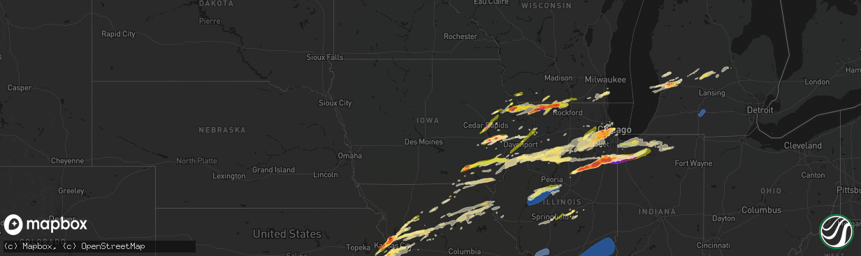
Hail Map in Iowa on March 10, 2026
The weather event in Iowa on March 10, 2026 includes Hail, Tornado, and Wind maps. 11 states and 1,358 cities were impacted and suffered possible damage. The total estimated number of properties impacted is 79,091.
Want more than just the map?
Turn this storm into a full workflow.
- Owner + property data so you know who to knock
- OnDemand branded weather history reports to win the "did we even have hail?" argument
- RoofTrace estimate so reps stop guessing numbers at the door
Bought this map? Upgrade within 7 days and we'll credit the $230. (10-15 min setup call)
Hail
Tornado
Wind
79,091
Estimated number of impacted properties by a 1.00" hail or larger24,302
Estimated number of impacted properties by a 1.75" hail or larger2,862
Estimated number of impacted properties by a 2.50" hail or largerStorm reports in Iowa
Iowa
| Date | Description |
|---|---|
| 03/10/20266:58 PM CDT | Delayed report via social media. Verified by ruler measurement. |
| 03/10/20266:53 PM CDT | A local report indicates 1.25 inch wind near 2 NW Sharon Center |
| 03/10/20266:45 PM CDT | Up to quarter size hail. Time of the event was estimated using radar. |
| 03/10/20266:40 PM CDT | Lasted from 640 to 650 pm. Covered the deck. No wind. |
| 03/10/20266:39 PM CDT | Occurring right now. |
| 03/10/20266:39 PM CDT | Report from mping: quarter |
| 03/10/20266:36 PM CDT | A local report indicates 1.25 inch wind near 3 S Buck Creek |
| 03/10/20266:35 PM CDT | A local report indicates 1.00 inch wind near 2 SE Davenport |
| 03/10/20266:33 PM CDT | At the cardinal high school. Hailed for 6 minutes until 6:39 pm. |
| 03/10/20266:23 PM CDT | A local report indicates 1.50 inch wind near Batavia |
| 03/10/20266:20 PM CDT | Quarter sized hail lasted for 5 minutes. |
| 03/10/20266:10 PM CDT | Pictures of sporadic golf ball sized hail mixed in with smaller hail. |
| 03/10/20266:07 PM CDT | At the cardinal high school. |
| 03/09/20269:50 PM CDT | Kbrl reported a 52 knot wind gust. |
| 03/09/20269:26 PM CDT | An ef1 tornado with max winds near 90 mph begun its 2.1 mile long path with damage to tree branches. The tornado then caused damage to some fascia on a house. It then c |
| 03/09/20269:10 PM CDT | A local report indicates 1.50 inch wind near 2 SW Donnellson |
| 03/09/20269:05 PM CDT | An ef1 tornado with peak winds of 95 to 100 mph begun its 1.5 mile long path by downing some tree branches. The tornado increased in strength causing damage to the door |
| 03/09/20269:05 PM CDT | Cattle shed and feed shed were blown down. Possible tornado. |
| 03/09/20268:09 PM CDT | Report from mping: half dollar |
| 03/09/20268:03 PM CDT | Lots of nickel to quarter. |
| 03/09/20267:39 PM CDT | A local report indicates 1.50 inch wind near 1 NE Rochester |
| 03/09/20267:30 PM CDT | A local report indicates 2.00 inch wind near Bernard |
| 03/09/20267:30 PM CDT | Delayed report via social media. |
| 03/09/20267:25 PM CDT | Time estimated by radar. |
| 03/09/20267:23 PM CDT | A local report indicates 2.75 inch wind near 3 SW West Branch |
| 03/09/20267:21 PM CDT | Report from mping: quarter |
| 03/09/20267:20 PM CDT | 10 minutes of quarter size hail. Hail is covering the ground. |
| 03/09/20267:17 PM CDT | A local report indicates 1.00 inch wind near 1 N Bernard |
| 03/09/20267:16 PM CDT | Report from mping: half dollar |
| 03/09/20267:15 PM CDT | A local report indicates 1.00 inch wind near 2 SE Iowa City |
| 03/09/20267:15 PM CDT | Time estimated by radar. |
| 03/09/20267:15 PM CDT | Size increased since last report. |
| 03/09/20267:13 PM CDT | Occurring right now. |
| 03/09/20267:13 PM CDT | 1 mile east of marion airport. |
| 03/09/20267:10 PM CDT | Delayed report. |
| 03/09/20267:09 PM CDT | A local report indicates 1.25 inch wind near 2 E Dubuque Regional Ar |
| 03/09/20267:09 PM CDT | A local report indicates 1.00 inch wind near 1 E Camanche |
| 03/09/20267:08 PM CDT | Delayed report. Marble to quarter sized hail. |
| 03/09/20267:08 PM CDT | Report from mping: half dollar |
| 03/09/20267:07 PM CDT | A local report indicates 1.00 inch wind near 4 NE Cedar Rapids Munic |
| 03/09/20267:05 PM CDT | Via social media. |
| 03/09/20267:04 PM CDT | A local report indicates 2.50 inch wind near 3 W Iowa City Municipal |
| 03/09/20267:03 PM CDT | Hail sizes between 1 to 2 inches in diameter. Time estimated by radar. |
| 03/09/20267:03 PM CDT | Via social media. |
| 03/09/20267:03 PM CDT | Report from mping: half dollar |
| 03/09/20267:02 PM CDT | Occurring right now. |
| 03/09/20267:00 PM CDT | A local report indicates 1.00 inch wind near 4 NE Cedar Rapids Munic |
| 03/09/20267:00 PM CDT | A local report indicates 1.00 inch wind near Cascade |
All States Impacted by Hail Map on March 10, 2026
Cities Impacted by Hail Map on March 10, 2026
- Dryden, TX
- Shattuck, OK
- Sheffield, TX
- Ozona, TX
- Higgins, TX
- Canadian, TX
- Wingate, TX
- Flanagan, IL
- El Paso, IL
- Minonk, IL
- Graymont, IL
- Pontiac, IL
- Tuscola, TX
- Gridley, IL
- Marseilles, IL
- Ovalo, TX
- Buffalo Gap, TX
- Abilene, TX
- Odell, IL
- Fargo, OK
- Buffalo, OK
- Morris, IL
- Seneca, IL
- Newark, IL
- Del Rio, TX
- May, OK
- Follett, TX
- Booker, TX
- Minooka, IL
- Yorkville, IL
- Trent, TX
- Merkel, TX
- Hawley, TX
- Anson, TX
- Clyde, TX
- Lueders, TX
- Avoca, TX
- Stamford, TX
- Freedom, OK
- Joliet, IL
- Plainfield, IL
- Shorewood, IL
- Oswego, IL
- Kempton, IL
- Emington, IL
- Cabery, IL
- Mertzon, TX
- Comstock, TX
- San Angelo, TX
- Buckingham, IL
- Reddick, IL
- Dwight, IL
- Campus, IL
- Lemont, IL
- Lockport, IL
- Romeoville, IL
- Crest Hill, IL
- Bolingbrook, IL
- Woodridge, IL
- Naperville, IL
- Norton, TX
- Baird, TX
- Eldorado, TX
- Brackettville, TX
- Haskell, TX
- Winters, TX
- Balko, OK
- Herscher, IL
- Alva, OK
- Laughlin Afb, TX
- Downers Grove, IL
- Willowbrook, IL
- Darien, IL
- Westmont, IL
- Coldwater, KS
- Hinsdale, IL
- Clarendon Hills, IL
- Laverne, OK
- Bronte, TX
- Gracemont, OK
- Anadarko, OK
- Oak Brook, IL
- Bonfield, IL
- Union Hill, IL
- Lake City, KS
- Weinert, TX
- Grandfield, OK
- Kankakee, IL
- Moran, TX
- Binger, OK
- Sonora, TX
- Lawn, TX
- Willow Springs, IL
- La Grange, IL
- Western Springs, IL
- Seaton, IL
- Mediapolis, IA
- Oakville, IA
- Hickory Hills, IL
- Justice, IL
- Devol, OK
- Medicine Lodge, KS
- Hillside, IL
- Westchester, IL
- La Grange Park, IL
- Brookfield, IL
- Broadview, IL
- Lyons, IL
- Bourbonnais, IL
- Summit Argo, IL
- Hines, IL
- Maywood, IL
- Forest Park, IL
- Riverside, IL
- Cicero, IL
- Berwyn, IL
- Chicago, IL
- Bradley, IL
- Toulon, IL
- Neponset, IL
- Minco, OK
- Agency, IA
- Eldon, IA
- Ottumwa, IA
- Keithsburg, IL
- Randlett, OK
- West Burlington, IA
- Danville, IA
- Burlington, IA
- Aledo, IL
- Alexis, IL
- Bloomfield, IA
- Middletown, IA
- Sperry, IA
- Goree, TX
- Seymour, TX
- Throckmorton, TX
- Woodhull, IL
- Cambridge, IL
- Altona, IL
- Eudora, KS
- Baldwin City, KS
- Walters, OK
- Hinton, OK
- Calumet, OK
- Bridgeview, IL
- El Reno, OK
- Oak Park, IL
- River Forest, IL
- Bellwood, IL
- Momence, IL
- Union City, OK
- Okarche, OK
- Kingfisher, OK
- Lockridge, IA
- Fairfield, IA
- Kansas City, MO
- Batavia, IA
- Kewanee, IL
- Galva, IL
- Kansas City, KS
- De Soto, KS
- Joy, IL
- Little York, IL
- Saint Anne, IL
- Buda, IL
- New Windsor, IL
- Viola, IL
- Uvalde, TX
- Barksdale, TX
- Rocksprings, TX
- Bonner Springs, KS
- Linwood, KS
- Bradford, IL
- Cisco, TX
- Breckenridge, TX
- Aroma Park, IL
- Yukon, OK
- Dover, OK
- Hennessey, OK
- Grant Park, IL
- Manteno, IL
- Sharon, KS
- Camp Wood, TX
- Rio Frio, TX
- Leakey, TX
- Mustang, OK
- Oquawka, IL
- Princeton, IL
- Tiskilwa, IL
- Wyanet, IL
- Shawnee, KS
- Riverside, MO
- Coggon, IA
- Monticello, IA
- Alpha, IL
- Ophiem, IL
- Libertyville, IA
- Lynn Center, IL
- Electra, TX
- Central City, IA
- Annawan, IL
- Sheffield, IL
- Albany, TX
- Holt, MO
- Temple, OK
- Lawton, OK
- Oklahoma City, OK
- Reynolds, IL
- Illinois City, IL
- Taylor Ridge, IL
- Andalusia, IL
- Milan, IL
- Davenport, IA
- Buffalo, IA
- Blue Grass, IA
- Moline, IL
- Rock Island, IL
- Bettendorf, IA
- Le Claire, IA
- Pleasant Valley, IA
- Eldridge, IA
- Princeton, IA
- Cordova, IL
- Albany, IL
- Rio, IL
- Isabel, KS
- Wilmore, KS
- Attica, KS
- Brighton, IA
- North Henderson, IL
- Caddo, TX
- Zenda, KS
- Nashville, KS
- West Olive, MI
- Zeeland, MI
- Holland, MI
- Mineral, IL
- Lawson, MO
- Lathrop, MO
- Polo, MO
- Amana, IA
- Oxford, IA
- Iowa City, IA
- North Liberty, IA
- Tiffin, IA
- Oneida, IL
- Schneider, IN
- Lake Village, IN
- Lowell, IN
- Ottawa, IL
- Elizabeth, IL
- Hanover, IL
- Mount Pleasant, IA
- Wayland, IA
- Bethany, OK
- Kalona, IA
- Wellman, IA
- Liberty, MO
- Kearney, MO
- Camanche, IA
- Pembroke Township, IL
- Morocco, IN
- Comanche, OK
- Marlow, OK
- Duncan, OK
- Oklaunion, TX
- Harrold, TX
- Davidson, OK
- Swisher, IA
- Fairfax, IA
- Cedar Rapids, IA
- Ely, IA
- Marion, IA
- Mount Vernon, IA
- Springville, IA
- Riverside, IA
- Columbus Junction, IA
- Spivey, KS
- Sheridan, IL
- Sandwich, IL
- Zwingle, IA
- Dubuque, IA
- Stockton, IL
- Wedron, IL
- Serena, IL
- Winfield, IA
- Eden, TX
- Hudsonville, MI
- Jenison, MI
- Cascade, IA
- Bernard, IA
- Frederick, OK
- Peosta, IA
- Kingston, MO
- Hamilton, MO
- Concan, TX
- Coralville, IA
- Solon, IA
- Malden, IL
- Dover, IL
- Kent, IL
- Ranger, TX
- Demotte, IN
- Olds, IA
- Bishop Hill, IL
- Arlington, IL
- West Brooklyn, IL
- Utica, IL
- West Branch, IA
- West Liberty, IA
- Edmond, OK
- Jones, OK
- Spencer, OK
- Atalissa, IA
- Tipton, IA
- Plano, IL
- Paint Rock, TX
- La Motte, IA
- Peru, IL
- Mendota, IL
- Lena, IL
- Morning Sun, IA
- Harper, KS
- Letts, IA
- Wapello, IA
- Utopia, TX
- Anamosa, IA
- Elgin, OK
- Freeport, IL
- Floris, IA
- Selma, IA
- Kingman, KS
- Vanderpool, TX
- Grand Rapids, MI
- Menard, TX
- La Salle, IL
- Shelby, IN
- Hebron, IN
- Thayer, IN
- Prairieburg, IA
- Smithville, MO
- Strawn, TX
- Spring Valley, IL
- Cherry, IL
- Bison, OK
- Mount Union, IA
- Depue, IL
- Atkinson, IL
- La Moille, IL
- Troy Grove, IL
- Erie, IL
- Fulton, IL
- Clinton, IA
- Bristol, IL
- Sugar Grove, IL
- Big Rock, IL
- Aurora, IL
- Montgomery, IL
- Cheney, KS
- Elburn, IL
- North Aurora, IL
- Batavia, IL
- Geneva, IL
- Mooseheart, IL
- Warrenville, IL
- West Chicago, IL
- Norwich, KS
- Murdock, KS
- Excelsior Springs, MO
- Saint Charles, IL
- Breckenridge, MO
- Graford, TX
- Rayville, MO
- Chillicothe, MO
- Galena, IL
- Bellevue, IA
- Medina, TX
- Durand, IL
- McConnell, IL
- Dakota, IL
- Rock City, IL
- Davis, IL
- Leland, IL
- Glenwood, MO
- Lancaster, MO
- Downing, MO
- Grandview, IA
- New Boston, IL
- Macatawa, MI
- East Dubuque, IL
- Wheatfield, IN
- Douds, IA
- Choctaw, OK
- Lisbon, IA
- Vernon, TX
- Wyoming, IL
- Graham, TX
- Coleman, TX
- Seatonville, IL
- Ladd, IL
- Triumph, IL
- La Fayette, IL
- Dalzell, IL
- Birmingham, IA
- Earlville, IL
- Chula, MO
- Somonauk, IL
- Richmond, MO
- Fair Oaks, IN
- Rensselaer, IN
- San Pierre, IN
- Kouts, IN
- La Crosse, IN
- Garden Plain, KS
- Goddard, KS
- Hardin, MO
- Gallatin, MO
- Luther, OK
- Harrah, OK
- Wellston, OK
- Andale, KS
- Mount Hope, KS
- Union Grove, WI
- Twin Lakes, WI
- Burlington, WI
- Memphis, MO
- Beloit, WI
- Nocona, TX
- Sawyer, KS
- Cyril, OK
- Bennett, IA
- Wilton, IA
- Moscow, IA
- Rockton, IL
- Scales Mound, IL
- Santa Anna, TX
- Genoa City, WI
- Wheeling, MO
- Linneus, MO
- Browning, MO
- Purdin, MO
- Orrick, MO
- Mechanicsville, IA
- Pulaski, IA
- Bangs, TX
- Brownwood, TX
- Fletcher, OK
- Henry, IL
- Putnam, IL
- Palo Pinto, TX
- Cedarville, IL
- Brodhead, WI
- Milan, MO
- Milton, KS
- Rush Springs, OK
- Lindsay, OK
- Colwich, KS
- Wichita, KS
- Norborne, MO
- Bristol, WI
- Kansasville, WI
- Sturtevant, WI
- Salem, WI
- Kenosha, WI
- Pearl City, IL
- Kerrville, TX
- Bandera, TX
- Center Point, TX
- Melvin, TX
- Jacksboro, TX
- Mineral Wells, TX
- Milton, IA
- Cantril, IA
- Gordon, TX
- Green Castle, MO
- Green City, MO
- Farley, IA
- Epworth, IA
- Lake Geneva, WI
- McNabb, IL
- Hennepin, IL
- Magnolia, IL
- Geneseo, IL
- Coatsville, MO
- Shirland, IL
- Winnebago, IL
- Warren, IL
- Wyoming, MI
- Kiowa, KS
- Valley Center, KS
- Worthington, IA
- Sparland, IL
- Lone Tree, IA
- Novinger, MO
- North Judson, IN
- Hanna, IN
- Wanatah, IN
- Maize, KS
- Chandler, OK
- Carrollton, MO
- Grandville, MI
- Prophetstown, IL
- Burlington, OK
- Comfort, TX
- Racine, WI
- Perrin, TX
- Mount Sterling, IA
- Arbela, MO
- Orangeville, IL
- Apple River, IL
- Muir, MI
- Ionia, MI
- Weatherford, TX
- Whitt, TX
- Argonia, KS
- Hazelton, KS
- Brookfield, MO
- Salem, IA
- Stockport, IA
- Lostant, IL
- Lacon, IL
- Varna, IL
- Millsap, TX
- Shannon, IL
- Bureau, IL
- Millington, IL
- Millbrook, IL
- Knox, IN
- Sedgwick, KS
- Greentop, MO
- Queen City, MO
- Kechi, KS
- Greenwich, KS
- Benton, KS
- Plymouth, IN
- Hamlet, IN
- Grovertown, IN
- Lenexa, KS
- Basehor, KS
- Olathe, KS
- De Leon, TX
- Comanche, TX
- Waldron, KS
- Winslow, IL
- Conway Springs, KS
- Poolville, TX
- Bridgeport, TX
- Bonaparte, IA
- Farmington, IA
- Luray, MO
- Kahoka, MO
- Newton, KS
- Whitewater, KS
- Dublin, TX
- Streator, IL
- Tonica, IL
- Anthony, KS
- Amorita, OK
- Bucklin, MO
- Hubbardston, MI
- Fowler, MI
- Pewamo, MI
- Keosauqua, IA
- Tampico, IL
- Burns, KS
- Ethel, MO
- Fredericksburg, TX
- Sherrard, IL
- Pocasset, OK
- Springtown, TX
- Stillwater, OK
- Mulhall, OK
- Bogard, MO
- Walkerton, IN
- Augusta, KS
- Andover, KS
- El Dorado, KS
- Towanda, KS
- Bluff City, KS
- Caldwell, KS
- Carmen, OK
- Cherokee, OK
- Durant, IA
- Walcott, IA
- Stockton, IA
- Chico, TX
- Lisle, IL
- Paradise, TX
- Perrinton, MI
- Potwin, KS
- Quenemo, KS
- Bosworth, MO
- Manchester, OK
- Donnellson, IA
- Mendon, MO
- Waverly, KS
- Melvern, KS
- Wellsville, KS
- Pecatonica, IL
- Rockford, IL
- Saint Johns, MI
- Danville, KS
- Leonore, IL
- Ada, MI
- New Cambria, MO
- Deer Grove, IL
- Spring Hill, KS
- Edgerton, KS
- Viola, KS
- Clearwater, KS
- Lebo, KS
- Cottonwood Falls, KS
- Cassoday, KS
- Callao, MO
- Elmer, MO
- Stephenville, TX
- Cedar Point, KS
- Wakita, OK
- Helena, OK
- Freeport, KS
- Overland Park, KS
- Pompeii, MI
- Ashley, MI
- Carson City, MI
- Maple Rapids, MI
- Middleton, MI
- Medford, OK
- Azle, TX
- Dixon, IA
- Donahue, IA
- Pomona, KS
- Marceline, MO
- Bevier, MO
- Atlanta, MO
- Novelty, MO
- La Plata, MO
- Davenport, OK
- Sparks, OK
- Meeker, OK
- Gardner, KS
- Potosi, WI
- Ottawa, KS
- Millersview, TX
- Long Grove, IA
- Jet, OK
- Peck, KS
- Fruitport, MI
- Nunica, MI
- Triplett, MO
- Decatur, TX
- Haysville, KS
- Alvord, TX
- Grand Ridge, IL
- Leon, KS
- Mcconnell Afb, KS
- Ithaca, MI
- Boyd, TX
- West Point, IA
- Stroud, OK
- Lohn, TX
- Ravenna, MI
- Coopersville, MI
- Reading, KS
- Emporia, KS
- Neosho Rapids, KS
- Eureka, KS
- Mulvane, KS
- Conklin, MI
- Independence, MO
- Camden, MO
- Lyndon, KS
- Salisbury, MO
- Leawood, KS
- Nash, OK
- North Liberty, IN
- Homer Glen, IL
- Burbank, IL
- Ransom, IL
- Elsie, MI
- Wellington, KS
- Derby, KS
- Doole, TX
- Leonard, MO
- Rose Hill, KS
- Belle Plaine, KS
- Rhome, TX
- Krum, TX
- Ponder, TX
- Essex, IL
- Bannister, MI
- Lewistown, MO
- La Belle, MO
- Knox City, MO
- Osage City, KS
- Sanger, TX
- Junction, TX
- South Haven, KS
- Madison, KS
- Mayfield, KS
- Darlington, WI
- De Witt, IA
- Macon, MO
- Kinsman, IL
- Orleans, MI
- Greenville, MI
- Casnovia, MI
- Gardner, IL
- Anabel, MO
- Rothville, MO
- Oakley, MI
- Henderson, MI
- Chesaning, MI
- Verona, IL
- Brady, TX
- Era, TX
- Gainesville, TX
- Valley View, TX
- Muenster, TX
- Lindsay, TX
- Whitesboro, TX
- Thackerville, OK
- Marietta, OK
- Sadler, TX
- Rosston, TX
- Lebanon, OK
- Overbrook, OK
- Ardmore, OK
- Kingston, OK
- Burneyville, OK
- Madill, OK
- Gordonville, TX
- Pottsboro, TX
- Braceville, IL
- New London, IA
- Wilmington, IL
- Brant, MI
- Sheridan, MI
- Fenwick, MI
- Hartford, KS
- Clarence, MO
- Excello, MO
- Granville, IL
- Amboy, IL
- Monticello, MO
- Canton, MO
- La Grange, MO
- Rock, KS
- Saint Charles, MI
- Prairie Village, KS
- Stilwell, KS
- Douglass, KS
- Dyer, IN
- Newark, MO
- Shelbyville, MO
- Bethel, MO
- Udall, KS
- Kent City, MI
- Mannsville, OK
- Atlanta, KS
- London, TX
- Paola, KS
- Schererville, IN
- Griffith, IN
- Crown Point, IN
- Merrillville, IN
- Saint John, IN
- Gary, IN
- Highland, IN
- Gridley, KS
- Burlington, KS
- Depew, OK
- Bristow, OK
- Seminole, OK
- Lentner, MO
- Warsaw, IL
- Stanton, MI
- Mansfield, TX
- Prague, OK
- Shawnee, OK
- Mark, IL
- Yarmouth, IA
- Bucyrus, KS
- Lees Summit, MO
- Blue Springs, MO
- Mead, OK
- Durant, OK
- Grain Valley, MO
- Oak Grove, MO
- Lake Station, IN
- Hobart, IN
- Valparaiso, IN
- Chesterton, IN
- Portage, IN
- Grandview, MO
- Philadelphia, MO
- Durham, MO
- Emden, MO
- Ewing, MO
- Latham, KS
- Wheaton, IL
- Oglesby, IL
- Crystal, MI
- Savanna, IL
- Belton, MO
- Hale, MO
- Westville, IN
- La Porte, IN
- Michigan City, IN
- Piedmont, KS
- Bates City, MO
- Napoleon, MO
- Buckner, MO
- Ursa, IL
- Maywood, MO
- Wellington, MO
- Lexington, MO
- Mendon, IL
- Union Mills, IN
- Quincy, IL
- Fowler, IL
- Paloma, IL
- Rantoul, KS
- Osawatomie, KS
- Dover, MO
- Brunswick, MO
- Odessa, MO
- Bixby, OK
- Burt, MI
- Broken Arrow, OK
- Coweta, OK
- Inola, OK
- Hopkinton, IA
- Manhattan, IL
- Elwood, IL
- Pontotoc, TX
- Oak Lawn, IL
- Palos Park, IL
- Lone Jack, MO
- Raymore, MO
- Greenwood, MO
- Tarpley, TX
- Chouteau, OK
- Pryor, OK
- Claremore, OK
- Pipe Creek, TX
- Boerne, TX
- Adair, OK
- Locust Grove, OK
- Llano, TX
- Lampasas, TX
- Buchanan Dam, TX
- Tow, TX
- Burnet, TX
- Bluffton, TX
- Kingsland, TX
- Salina, OK
- Browning, IL
- Bath, IL
- Beardstown, IL
- Lometa, TX
- San Saba, TX
- Cherokee, TX
- Bend, TX
- Valley Spring, TX
- Strang, OK
- Big Cabin, OK
- Vinita, OK
- South Bend, IN
- Kingsford Heights, IN
- Lakeville, IN
- Waverly, MO
- Frankfort, IL
- Ipava, IL
- Astoria, IL
- Pleasant Hill, MO
- Hillsboro, IA
- Goldthwaite, TX
- Bennington, OK
- Boswell, OK
- Alma, MO
- Lewistown, IL
- Canton, IL
- De Witt, MO
- Malta Bend, MO
- Ohio, IL
- Keytesville, MO
- Chandlerville, IL
- Kilbourne, IL
- Topeka, IL
- Easton, IL
- Havana, IL
- Eucha, OK
- Spavinaw, OK
- Rose, OK
- Kempner, TX
- Marble Falls, TX
- Marshall, MI
- Homer, MI
- Manito, IL
- Forest City, IL
- San Jose, IL
- Green Valley, IL
- Mason City, IL
- Jay, OK
- Colcord, OK
- Fort Hood, TX
- Copperas Cove, TX
- Killeen, TX
- Albion, MI
- Delavan, IL
- Miami, MO
- Parsons, KS
- Bremen, IN
- Nappanee, IN
- Wakarusa, IN
- Mishawaka, IN
- Dalton, MO
- Liverpool, IL
- Hamilton, TX
- Evant, TX
- Clifton Hill, MO
- Hugo, OK
- Grant, OK
- Saint Paul, KS
- Nolan, TX
- Deepwater, MO
- Clinton, MO
- Wilburton, OK
- Talihina, OK
- Red Oak, OK
- Tremont, IL
- Mackinaw, IL
- Hopedale, IL
- Minier, IL
- Warsaw, MO
- Maple Park, IL
- Goose Lake, IA
- Bryant, IA
- Onslow, IA
- Preston, IA
- Fort Madison, IA
- Cornell, IL
- Villa Park, IL
- Glen Ellyn, IL
- Lombard, IL
- Palos Hills, IL
- Mokena, IL
- New Lenox, IL
- Mazon, IL
- Pekin, IL
- Comstock Park, MI
- Juda, WI
- Allendale, MI
- Cleveland, MO
- Louisburg, KS
- Fenton, IL
- Morrison, IL
- Goshen, IN
- Wasco, IL
- Tryon, OK
- Milford, IN
- South Wilmington, IL
- Maquoketa, IA
- Delmar, IA
- Moberly, MO
- Cairo, MO
- Bryson, TX
- Madison, MO
- Shelbina, MO
- Marne, MI
- Williams Bay, WI
- Fontana, WI
- Browntown, WI
- Monroe, WI
- South Wayne, WI
- Kirksville, MO
- Belding, MI
- Silver Lake, WI
- Charlotte, IA
- Baileyville, IL
- Dawn, MO
- Monee, IL
- Belmont, MI
- Lincolnwood, IL
- Evanston, IL
- Bourbon, IN
- Tinley Park, IL
- Oak Forest, IL
- Braymer, MO
- Martelle, IA
- New Paris, IN
- Carney, OK
- Bensenville, IL
- Melrose Park, IL
- Franklin Park, IL
- Elmhurst, IL
- Ridott, IL
- Eastland, TX
- Ligonier, IN
- Millersburg, IN
- Homestead, IA
- Middle Amana, IA
- Baldwin, IA
- McCune, KS
- Girard, KS
- Des Plaines, IL
- River Grove, IL
- Elmwood Park, IL
- Schiller Park, IL
- Harwood Heights, IL
- Clinton, WI
- New Vienna, IA
- Sublette, IL
- South Beloit, IL
- Roscoe, IL
- Conesville, IA
- Durango, IA
- Holy Cross, IA
- Welton, IA
- Chicago Ridge, IL
- Berkeley, IL
- Chicago Heights, IL
- Etna Green, IN
- South Pekin, IL
- Peculiar, MO
- Payson, IL
- Hull, IL
- Emden, IL
- Plainville, IL
- Syracuse, IN
- Hunt, TX
- Munday, TX
- Shady Point, OK
- Wister, OK
- Bokoshe, OK
- Spiro, OK
- Cameron, OK
- Wolcottville, IN
- Chester, AR
- Cedarville, AR
- Rudy, AR
- Liberty, IL
- Rochester, IL
- Pocola, OK
- Fort Smith, AR
- Mt Zion, IL
- Decatur, IL
- Macon, IL
- Springfield, IL
- Chatham, IL
- Edinburg, IL
- Mechanicsburg, IL
- Buffalo, IL
- Illiopolis, IL
- Waverly, IL
- Loami, IL
- Dalton City, IL
- Mountainburg, AR
- Bement, IL
- Harristown, IL
- Forsyth, IL
- Oreana, IL
- Elkins, AR
- Combs, AR
- Huntsville, AR
- Witter, AR
- Saint Paul, AR
- Wesley, AR
- Pettigrew, AR
- Kingston, AR
- Berryville, AR
- Ponca, AR
- Compton, AR
- Green Forest, AR
- Alpena, AR
- Harrison, AR
- Mulberry, AR
- Ozark, AR
- Oark, AR
- Alma, AR
- Lavaca, AR
- Van Buren, AR
- Dyer, AR
- Charleston, AR
- Barling, AR
- Cecil, AR
- Montgomery City, MO
- New Florence, MO
- High Hill, MO
- Jonesburg, MO
- Platteville, WI
- Golden Eagle, IL
- Saint Charles, MO
- Brussels, IL
- Grafton, IL
- Portage Des Sioux, MO
- Maroa, IL
- Warrensburg, IL
- Niantic, IL
- Blue Mound, IL
- Hammond, IL
- Cerro Gordo, IL
- Argenta, IL
- Mount Auburn, IL
- Glenarm, IL
- Auburn, IL
- Hartford, IL
- East Alton, IL
- Wood River, IL
- Roxana, IL
- Bethalto, IL
- Cottage Hills, IL
- Moro, IL
- South Roxana, IL
- Edwardsville, IL
- Worden, IL
- Hamel, IL
- Alhambra, IL
- Highland, IL
- Pocahontas, IL
- Walshville, IL
- Sorento, IL
- Livingston, IL
- New Douglas, IL
- Staunton, IL
- Dorsey, IL
- Boody, IL
- Skokie, IL
- Morton Grove, IL
- Stone Park, IL
- Elk Grove Village, IL
- Lenzburg, IL
- Marissa, IL
- New Athens, IL
- Saint Libory, IL
- Okawville, IL
- Addieville, IL
- Oakdale, IL
- Coulterville, IL
- Nashville, IL
- Centralia, IL
- Odin, IL
- Sandoval, IL
- Salem, IL
- Alma, IL
- Kinmundy, IL
- Iuka, IL
- Farina, IL
- Xenia, IL
- Walnut Hill, IL
- Dix, IL
- Kell, IL
- Ashley, IL
- Mount Erie, IL
- Mill Shoals, IL
- Newton, IL
- Dahlgren, IL
- Bonnie, IL
- Ellery, IL
- Tamaroa, IL
- Irvington, IL
- Mount Vernon, IL
- Edgewood, IL
- Du Quoin, IL
- Texico, IL
- Hoyleton, IL
- Willow Hill, IL
- Mason, IL
- Casey, IL
- Dundas, IL
- Opdyke, IL
- Scheller, IL
- Steeleville, IL
- Evansville, IL
- Rinard, IL
- Noble, IL
- Richview, IL
- West Liberty, IL
- Dieterich, IL
- Greenup, IL
- Keenes, IL
- Johnsonville, IL
- Yale, IL
- Wayne City, IL
- Golden Gate, IL
- Tilden, IL
- Waltonville, IL
- Ingraham, IL
- Baldwin, IL
- Cisne, IL
- Sparta, IL
- Geff, IL
- Percy, IL
- Fairfield, IL
- Cutler, IL
- West Salem, IL
- Sims, IL
- Campbell Hill, IL
- Burnt Prairie, IL
- Belle Rive, IL
- Wheeler, IL
- Louisville, IL
- Hidalgo, IL
- Woodlawn, IL
- Flora, IL
- Olney, IL
- Chester, IL
- Du Bois, IL
- Clay City, IL
- Walsh, IL
- Albion, IL
- Sailor Springs, IL
- Bluford, IL
- Barnhill, IL
- Pinckneyville, IL
- Ellis Grove, IL
- Corrigan, TX
- Jewett, IL
- West Union, IL
- Palestine, IL
- Martinsville, IL
- Sainte Marie, IL
- Hutsonville, IL
- Bridgeport, IL
- Flat Rock, IL
- West York, IL
- Oblong, IL
- Stoy, IL
- Annapolis, IL
- Marshall, IL
- Sumner, IL
- Robinson, IL
- Claremont, IL
- Thornton, AR
- Fordyce, AR
- Bearden, AR
- Janesville, WI
- Darien, WI
- Diboll, TX
- Kingsville, MO
- Higginsville, MO
- Brook, IN
- Apache, OK
- Cement, OK
- Argos, IN
- Albion, IN
- Orland, IN
- South Milford, IN
- Hudson, IN
- Corunna, IN
- Howe, IN
- North Webster, IN
- Pleasant Lake, IN
- Shipshewana, IN
- Hamilton, IN
- Leesburg, IN
- Warsaw, IN
- Kendallville, IN
- Ashley, IN
- Waterloo, IN
- Wawaka, IN
- Topeka, IN
- Rome City, IN
- Lagrange, IN
- Cromwell, IN
- Kimmell, IN
- Pierceton, IN
- Angola, IN
- Fremont, IN
- Larwill, IN
- Victoria, IL
- Speer, IL
- Williamsfield, IL
- Gladstone, IL
- Stronghurst, IL
- Wever, IA
- Denmark, IA
- Carman, IL
- Saint Mary, MO
- Leadwood, MO
- Belgrade, MO
- Bonne Terre, MO
- De Soto, MO
- Mineral Point, MO
- Bloomsdale, MO
- Irondale, MO
- Prairie Du Rocher, IL
- Fults, IL
- Modoc, IL
- Farmington, MO
- Valles Mines, MO
- Doe Run, MO
- Red Bud, IL
- Ironton, MO
- Bismarck, MO
- Park Hills, MO
- Potosi, MO
- Festus, MO
- Belleview, MO
- Sainte Genevieve, MO
- French Village, MO
- Caledonia, MO
- Cowgill, MO
- Missouri City, MO
- Garnett, KS
- Westphalia, KS
- Colony, KS
- Richmond, KS
- Welda, KS
- Moran, KS
- Greeley, KS
- Kincaid, KS
- Bronson, KS
- Mound City, KS
- Fontana, KS
- Centerville, KS
- Mapleton, KS
- Blue Mound, KS
- Lane, KS
- La Cygne, KS
- Parker, KS
- Le Roy, KS
- Lowry City, MO
- Collins, MO
- Schell City, MO
- Weaubleau, MO
- El Dorado Springs, MO
- Hermitage, MO
- Quincy, MO
- Rockville, MO
- Montrose, MO
- Butler, MO
- Osceola, MO
- Harwood, MO
- Wheatland, MO
- Appleton City, MO
- Rich Hill, MO
- Walker, MO
- Richards, MO
- Nevada, MO
- Stover, MO
- Preston, MO
- Macks Creek, MO
- Climax Springs, MO
- Edwards, MO
- Gravois Mills, MO
- Roach, MO
- Cross Timbers, MO
- Lincoln, MO
- Valliant, OK
- Garvin, OK
- Idabel, OK
- Broken Bow, OK
- Eagletown, OK
- De Queen, AR
- Gillham, AR
- Crosby, MS


