Hail Map in Weatherford, TX on March 7, 2016
The weather event in Weatherford, TX on March 7, 2016 includes Hail map. 5 states and 121 cities were impacted and suffered possible damage. The total estimated number of properties impacted is 1,222.
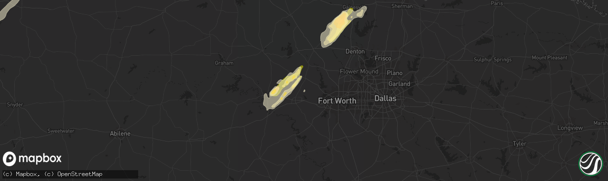
Hail
1,222
Estimated number of impacted properties by a 1.00" hail or larger162
Estimated number of impacted properties by a 1.75" hail or larger0
Estimated number of impacted properties by a 2.50" hail or largerStorm reports in Weatherford, TX
Weatherford, TX
| Date | Description |
|---|---|
| 03/06/20167:15 PM CST | Damage reported 700 block our lane. Roof blown off house. Time estimated. |
| 03/06/20166:37 PM CST | A local report indicates 1.00 inch wind near 6 N WEATHERFORD |
| 03/06/20166:25 PM CST | A local report indicates 1.00 inch wind near 6 N WEATHERFORD |
| 03/06/20166:15 PM CST | Damage reported 700 block our lane. Roof blown off house. Time estimated |
| 03/06/20166:10 PM CST | Structures and multiple cars damaged approx 2 miles east of cool near hwy 180. Winds estimated to be in excess of 50 to 60 mph. |
All Cities Impacted by Hail Map on March 7, 2016
- Mertzon, TX
- Christoval, TX
- San Angelo, TX
- Collinsville, TX
- Mcgregor, MN
- Palisade, MN
- Andrews, TX
- Era, TX
- Gainesville, TX
- Ozona, TX
- Barnsdall, OK
- Paducah, TX
- Bronte, TX
- Ballinger, TX
- Knott, TX
- Stanton, TX
- Seminole, TX
- Robert Lee, TX
- Eldorado, TX
- Welch, TX
- Ira, TX
- Coahoma, TX
- Big Spring, TX
- Gail, TX
- Aitkin, MN
- Valley View, TX
- Hext, TX
- Brady, TX
- Junction, TX
- Melvin, TX
- Mason, TX
- Sonora, TX
- Rocksprings, TX
- Menard, TX
- Roosevelt, TX
- London, TX
- Poolville, TX
- Springtown, TX
- Muenster, TX
- Iraan, TX
- Sadler, TX
- Whitesboro, TX
- Sherman, TX
- Pottsboro, TX
- Del Rio, TX
- Tahoka, TX
- Wilson, TX
- Ralls, TX
- Post, TX
- Millsap, TX
- Weatherford, TX
- Mangum, OK
- Fluvanna, TX
- Lamesa, TX
- Gould, OK
- Fort Stockton, TX
- Barnhart, TX
- Comstock, TX
- Sanger, TX
- Rosston, TX
- Krum, TX
- Decatur, TX
- Mineral Wells, TX
- Big Lake, TX
- Abilene, TX
- Clyde, TX
- Albany, TX
- Dryden, TX
- Carter, OK
- Rochelle, TX
- Forestburg, TX
- Cisco, TX
- Moran, TX
- Odonnell, TX
- Richland Springs, TX
- Sterling, KS
- Granite, OK
- Bridgeport, NE
- Santo, TX
- Paradise, TX
- Eldorado, OK
- Quanah, TX
- Crosbyton, TX
- Lenorah, TX
- Brownwood, TX
- Carlsbad, TX
- Talpa, TX
- Coleman, TX
- Denton, TX
- Eveleth, MN
- May, TX
- Bushnell, NE
- Winters, TX
- Norton, TX
- Miles, TX
- Rowena, TX
- Coats, KS
- Seagraves, TX
- Spur, TX
- Dickens, TX
- Breckenridge, TX
- Millersview, TX
- Foss, OK
- Mountain Park, OK
- Comanche, TX
- Sidney, TX
- De Leon, TX
- Snyder, TX
- Mereta, TX
- Eola, TX
- Tuscola, TX
- Gorman, TX
- Hollis, OK
- Wingate, TX
- Blackwell, TX
- Iuka, KS
- Turon, KS
- Pratt, KS
- Stafford, KS
- Sylvia, KS
- Bartlesville, OK


