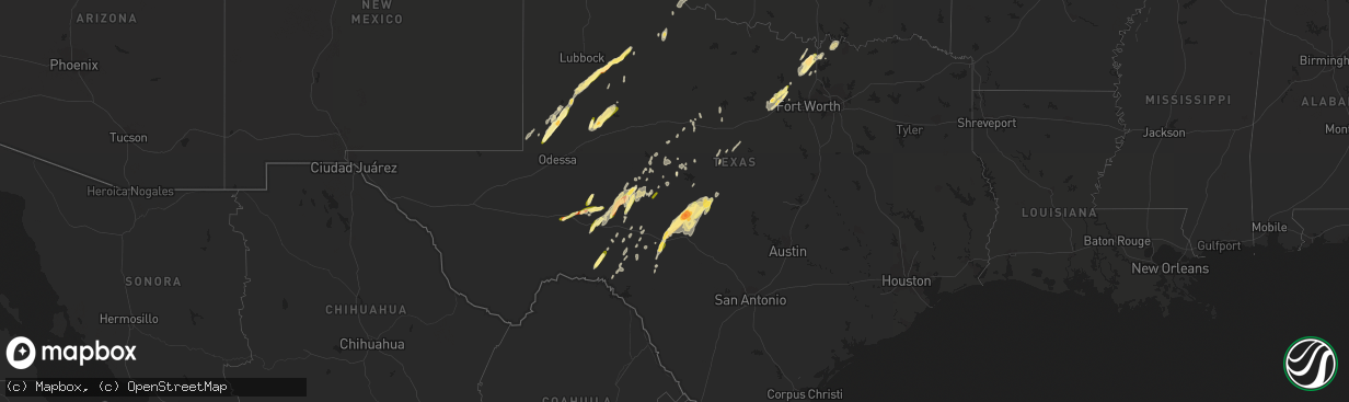
Hail Map in Texas on March 7, 2016
The weather event in Texas on March 7, 2016 includes Hail map. 5 states and 121 cities were impacted and suffered possible damage. The total estimated number of properties impacted is 9,309.
Want more than just the map?
Turn this storm into a full workflow.
- Owner + property data so you know who to knock
- OnDemand branded weather history reports to win the "did we even have hail?" argument
- RoofTrace estimate so reps stop guessing numbers at the door
Bought this map? Upgrade within 7 days and we'll credit the $230. (10-15 min setup call)
Hail
9,309
Estimated number of impacted properties by a 1.00" hail or larger1,581
Estimated number of impacted properties by a 1.75" hail or larger0
Estimated number of impacted properties by a 2.50" hail or largerStorm reports in Texas
Texas
| Date | Description |
|---|---|
| 03/07/20165:30 PM CST | A local report indicates 1.00 inch wind near 26 NW OZONA |
| 03/07/20165:30 AM CST | A boat dock in lake brownwood was lifted out of the water and tossed onto the bank. In addition...the roof was blown off of an outbuilding and several trees were downed |
| 03/07/20164:45 AM CST | Hail broke out a bedroom window. The spotter stated the hail was just under tennis ball size but larger than the size of an egg. |
| 03/07/20164:18 AM CST | A local report indicates 1.00 inch wind near 8 WNW CLEO |
| 03/07/20164:05 AM CST | Large tree uprooted. |
| 03/07/20162:30 AM CST | Portions of the roof were removed from a boat storage facility near knickerbocker road and south concho drive. Debris was scattered across cattail lane and struck an rv |
| 03/07/20162:25 AM CST | Wall blown in and roof blown off of storage shed and onto camper. Additional damage sustained to objects within storage shed. Maximum wind speeds estimated to be 80 mph |
| 03/07/20161:45 AM CST | A local report indicates 1.25 inch wind near MERTZON |
| 03/06/20169:05 PM CST | Outbuildings and power lines down on cemetery road in pottsboro |
| 03/06/20168:45 PM CST | Significant wind damage reported in city of whitesboro at sh377 and spur 153. Sitting rv blown onto car... 18 wheeler blown over... Dumpsters overturned... Power poles snappe |
| 03/06/20168:45 PM CST | Estimated wind gust of 80 mph in whitesboro |
| 03/06/20168:30 PM CST | Barns pushed into road... Power poles snapped... & structures damaged in the lake kiowa area |
| 03/06/20168:18 PM CST | Roof blown off mobile home off cr 209 in woodbine |
| 03/06/20168:18 PM CST | Power pole down in the 800 block of cr 219 |
| 03/06/20168:11 PM CST | Barn destroyed off fm 902 6-7 miles east southeast of gainesville. |
| 03/06/20167:58 PM CST | Quarter to golfball size hail reported in era. |
| 03/06/20167:25 PM CST | 3-5 inch diameter trees broken. 2-4 inch branches broken off a half dozen trees. Time estimated. |
| 03/06/20167:15 PM CST | Damage reported 700 block our lane. Roof blown off house. Time estimated. |
| 03/06/20166:37 PM CST | A local report indicates 1.00 inch wind near 6 N WEATHERFORD |
| 03/06/20166:25 PM CST | A local report indicates 1.00 inch wind near 6 N WEATHERFORD |
| 03/06/20166:15 PM CST | Damage reported 700 block our lane. Roof blown off house. Time estimated |
| 03/06/20166:10 PM CST | Structures and multiple cars damaged approx 2 miles east of cool near hwy 180. Winds estimated to be in excess of 50 to 60 mph. |
Cities Impacted by Hail Map on March 7, 2016
- Mertzon, TX
- Christoval, TX
- San Angelo, TX
- Collinsville, TX
- Mcgregor, MN
- Palisade, MN
- Andrews, TX
- Era, TX
- Gainesville, TX
- Ozona, TX
- Barnsdall, OK
- Paducah, TX
- Bronte, TX
- Ballinger, TX
- Knott, TX
- Stanton, TX
- Seminole, TX
- Robert Lee, TX
- Eldorado, TX
- Welch, TX
- Ira, TX
- Coahoma, TX
- Big Spring, TX
- Gail, TX
- Aitkin, MN
- Valley View, TX
- Hext, TX
- Brady, TX
- Junction, TX
- Melvin, TX
- Mason, TX
- Sonora, TX
- Rocksprings, TX
- Menard, TX
- Roosevelt, TX
- London, TX
- Poolville, TX
- Springtown, TX
- Muenster, TX
- Iraan, TX
- Sadler, TX
- Whitesboro, TX
- Sherman, TX
- Pottsboro, TX
- Del Rio, TX
- Tahoka, TX
- Wilson, TX
- Ralls, TX
- Post, TX
- Millsap, TX
- Weatherford, TX
- Mangum, OK
- Fluvanna, TX
- Lamesa, TX
- Gould, OK
- Fort Stockton, TX
- Barnhart, TX
- Comstock, TX
- Sanger, TX
- Rosston, TX
- Krum, TX
- Decatur, TX
- Mineral Wells, TX
- Big Lake, TX
- Abilene, TX
- Clyde, TX
- Albany, TX
- Dryden, TX
- Carter, OK
- Rochelle, TX
- Forestburg, TX
- Cisco, TX
- Moran, TX
- Odonnell, TX
- Richland Springs, TX
- Sterling, KS
- Granite, OK
- Bridgeport, NE
- Santo, TX
- Paradise, TX
- Eldorado, OK
- Quanah, TX
- Crosbyton, TX
- Lenorah, TX
- Brownwood, TX
- Carlsbad, TX
- Talpa, TX
- Coleman, TX
- Denton, TX
- Eveleth, MN
- May, TX
- Bushnell, NE
- Winters, TX
- Norton, TX
- Miles, TX
- Rowena, TX
- Coats, KS
- Seagraves, TX
- Spur, TX
- Dickens, TX
- Breckenridge, TX
- Millersview, TX
- Foss, OK
- Mountain Park, OK
- Comanche, TX
- Sidney, TX
- De Leon, TX
- Snyder, TX
- Mereta, TX
- Eola, TX
- Tuscola, TX
- Gorman, TX
- Hollis, OK
- Wingate, TX
- Blackwell, TX
- Iuka, KS
- Turon, KS
- Pratt, KS
- Stafford, KS
- Sylvia, KS
- Bartlesville, OK


