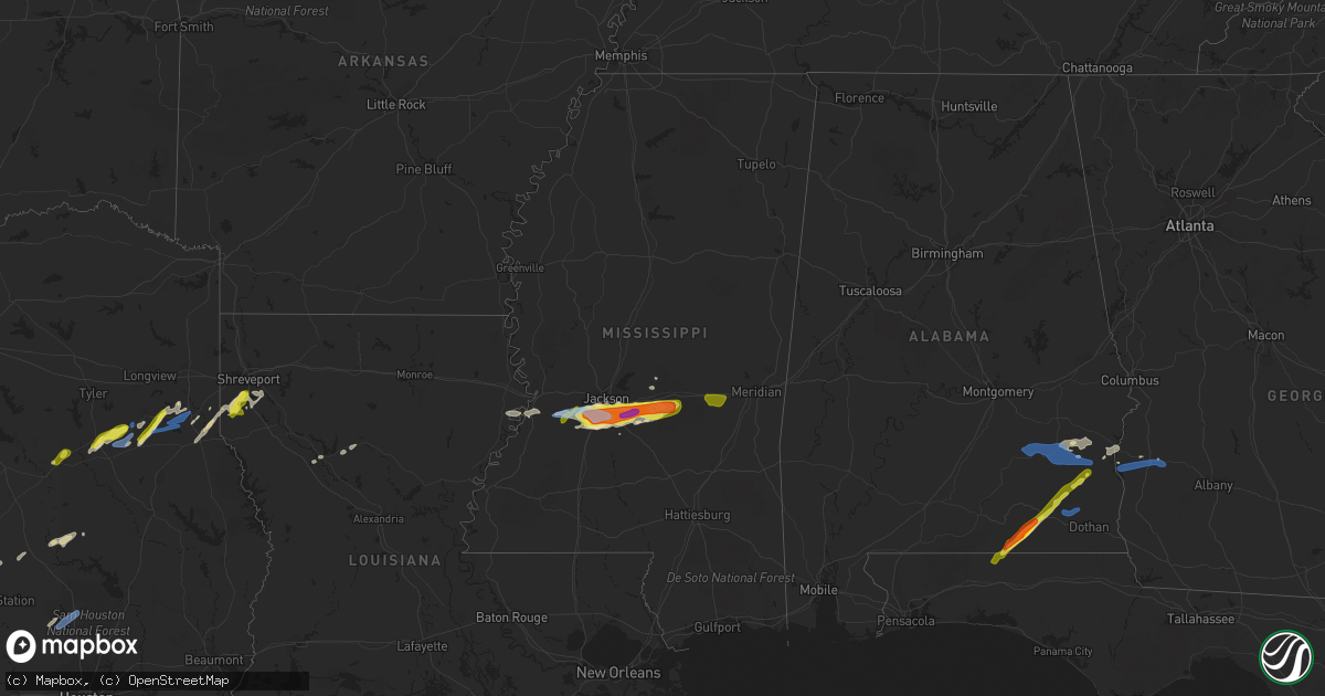
Hail Map in Mississippi on March 4, 2020
Get this storm
March 4 map
$229
one time, instant access
Download today. No call, no setup
Keep the $229
Bought the map and want the full workflow? Apply the entire $229 to a subscription within 7 days. None of it is wasted.
Every map, not just this one
This buys you this map. Subscription and you get every map we run, in the markets you choose from a few cities to whole states to nationwide. Plus real-time alerts the moment a storm fires.
Contact data
Name, contact info, occupancy, even credit band for addresses in the footprint. You go from where it hit to who to call.
Become the source they trust
Unlimited branding weather history reports on demand. You already have the documented answer ready for the property owner, and you are the one who showed up with it.
Property data and RoofTrace estimates
Pull up any address you have got, its value and the exact code rules for that jurisdiction, straight from One Click Code. Then RoofTrace estimates the squares, pitch, and roof value, priced the way you price.
Storm reports in Mississippi
Mississippi
| Date | Description |
|---|---|
| 03/04/202011:45 AM CST | A tree was blown down onto county road 420 near the lauderdale county line. Time estimated from radar. |
| 03/04/202010:24 AM CST | Hail up to the size of golf balls began falling along shiloh road east of brandon. |
| 03/04/202010:22 AM CST | Hail up to the size of quarters was beginning to fall along shiloh road east of brandon. |
| 03/04/202010:20 AM CST | Public report of 2 inch hail near shell oil rd and hwy 18. |
| 03/04/202010:15 AM CST | Hail of nickel up to quarter size was falling at brandon high school. |
| 03/04/202010:14 AM CST | Dime to quarter size hail was falling in the robinhood neighborhood. Report with video relayed via twitter. |
| 03/04/202010:08 AM CST | Hail to slightly larger than quarter size fell in richland. |
| 03/04/202010:08 AM CST | Hail up to the size of quarters was falling at the mississippi state hospital. |
| 03/04/202010:08 AM CST | 1.5 inch hail fell east of richland. |
| 03/04/202010:07 AM CST | Hail up to the size of quarters fell at the mississippi emergency management agency office. |
| 03/04/202010:00 AM CST | Hail up to the size of quarters fell in the cleary heights community. Report with video relayed via twitter. |
| 03/04/20209:57 AM CST | Golf ball size hail was falling in byram. |
| 03/04/20209:55 AM CST | Hail up to the size of golf balls was falling along interstate 55 near terry. Small limbs and quickly ponding water were also on the road. |
| 03/04/20209:53 AM CST | Hail up to the size of quarters west of byram reported via mping. |
| 03/04/20204:51 AM CST | At 1051 AM CST, severe thunderstorms were located along a line extending from 6 miles southeast of Forest to Pineville, moving east at 60 mph. HAZARD...60 mph wind gusts and quarter size hail. SOURCE...Radar indicated. IMPACT...Hail damage to vehicles is expected. Expect wind damage to roofs, siding, and trees. Severe thunderstorms will be near... Lawrence and Roberts around 1100 AM CST. Garlandville around 1105 AM CST. Newton around 1110 AM CST. Rose Hill around 1115 AM CST.Other locations impacted by these severe thunderstorms includeMontrose, Chunky and Hickory. |
| 03/04/20204:08 AM CST | At 1007 AM CST, severe thunderstorms were located along a line extending from Pearl to near Star, moving east at 65 mph. HAZARD...60 mph wind gusts and quarter size hail. SOURCE...Radar indicated. IMPACT...Hail damage to vehicles is expected. Expect wind damage to roofs, siding, and trees. Severe thunderstorms will be near... Cato and Johns around 1020 AM CST. Pelahatchie around 1025 AM CST. White Oak around 1030 AM CST. Pulaski and Burns around 1035 AM CST. Homewood around 1040 AM CST. Pineville around 1045 AM CST.Other locations impacted by these severe thunderstorms includePolkville and Puckett. |
| 03/04/20203:30 AM CST | At 930 AM CST, severe thunderstorms were located along a line extending from near Newman to near Reganton to near Carpenter, moving east at 60 mph. HAZARD...60 mph wind gusts and quarter size hail. SOURCE...Radar indicated. IMPACT...Hail damage to vehicles is expected. Expect wind damage to roofs, siding, and trees. Severe thunderstorms will be near... Utica around 935 AM CST. Dry Grove around 945 AM CST. Raymond around 950 AM CST. Jackson, Clinton, Byram and Terry around 955 AM CST. Whites around 1000 AM CST. Richland, Florence and Monterey around 1005 AM CST. Pearl, Flowood and Star around 1010 AM CST.Other locations impacted by these severe thunderstorms includeLearned. |
| 03/03/202011:15 PM CST | At 515 AM CST, a severe thunderstorm was located near Ellisville, moving east at 40 mph. HAZARD...Golf ball size hail and 60 mph wind gusts. SOURCE...Radar indicated. IMPACT...People and animals outdoors will be injured. Expect hail damage to roofs, siding, windows, and vehicles. Expect wind damage to roofs, siding, and trees. This severe thunderstorm will be near... Ellisville around 520 AM CST. Laurel around 525 AM CST. Tuckers Crossing around 530 AM CST. Sandersville around 535 AM CST. Mill Creek around 545 AM CST.Other locations impacted by this severe thunderstorm include Soso. |
| 03/03/202010:31 PM CST | At 431 AM CST, a severe thunderstorm was located near Goodman, or 10 miles south of Durant, moving east at 55 mph. HAZARD...60 mph wind gusts and quarter size hail. SOURCE...Radar indicated. IMPACT...Hail damage to vehicles is expected. Expect wind damage to roofs, siding, and trees. This severe thunderstorm will be near... Newport around 440 AM CST. Mcadams and Thomastown around 445 AM CST. Kosciusko and Singleton around 450 AM CST. Smyrna around 455 AM CST. Zama around 500 AM CST.Other locations impacted by this severe thunderstorm include Etheland Sallis. |
| 03/03/202010:11 PM CST | At 410 AM CST, severe thunderstorms were located along a line extending from Marion to Zero to near Stonewall, moving east at 60 mph. This storm has a history of producing wind damage. HAZARD...70 mph wind gusts and quarter size hail. SOURCE...Radar indicated. IMPACT...Hail damage to vehicles is expected. Expect considerable tree damage. Wind damage is also likely to mobile homes, roofs, and outbuildings. Locations impacted include... Butler, Lisman and Pennington. |
| 03/03/20209:57 PM CST | At 357 AM CST, a severe thunderstorm was located near Yazoo City, moving east at 65 mph. HAZARD...60 mph wind gusts and half dollar size hail. SOURCE...Radar indicated. IMPACT...Hail damage to vehicles is expected. Expect wind damage to roofs, siding, and trees. This severe thunderstorm will be near... Benton around 405 AM CST. Vaughan around 415 AM CST. Pickens around 420 AM CST. Goodman and Cameron around 425 AM CST. Camden around 430 AM CST. |
| 03/03/20209:44 PM CST | At 344 AM CST, a severe thunderstorm was located over Glancy, or near Hazlehurst, moving east at 35 mph. HAZARD...60 mph wind gusts and half dollar size hail. SOURCE...Radar indicated. IMPACT...Hail damage to vehicles is expected. Expect wind damage to roofs, siding, and trees. This severe thunderstorm will be near... Hazlehurst and Martinsville around 350 AM CST. Wesson around 355 AM CST. Rockport and Oma around 420 AM CST. Union around 425 AM CST. Shivers around 435 AM CST.Other locations impacted by this severe thunderstorm includeBeauregard, New Hebron and Georgetown. |
| 03/03/20209:23 PM CST | At 322 AM CST, a severe thunderstorm was located near Conehatta, or 10 miles east of Forest, moving east at 55 mph. HAZARD...70 mph wind gusts and half dollar size hail. SOURCE...Radar indicated. IMPACT...Hail damage to vehicles is expected. Expect considerable tree damage. Wind damage is also likely to mobile homes, roofs, and outbuildings. This severe thunderstorm will be near... Newton and Decatur around 335 AM CST. Meehan around 350 AM CST. Nellieburg around 355 AM CST. Savoy around 400 AM CST.Other locations impacted by this severe thunderstorm include Chunky,Lake and Hickory. |
| 03/03/20209:10 PM CST | At 310 AM CST, a severe thunderstorm was located near Laurel, moving east at 45 mph. HAZARD...60 mph wind gusts and quarter size hail. SOURCE...Radar indicated. IMPACT...Hail damage to vehicles is expected. Expect wind damage to roofs, siding, and trees. This severe thunderstorm will be near... Sandersville around 320 AM CST. Mill Creek around 325 AM CST. |
| 03/03/20208:52 PM CST | At 252 AM CST, a severe thunderstorm was located over Leesburg, or 10 miles northwest of Morton, moving east at 55 mph. HAZARD...Tennis ball size hail and 70 mph wind gusts. SOURCE...Radar indicated. IMPACT...People and animals outdoors will be injured. Expect hail damage to roofs, siding, windows, and vehicles. Expect considerable tree damage. Wind damage is also likely to mobile homes, roofs, and outbuildings. This severe thunderstorm will be near... Branch and Ludlow around 255 AM CST. Morton and Forkville around 300 AM CST. Forest, Harperville and Hillsboro around 310 AM CST. Steele around 315 AM CST. Lawrence and Conehatta around 325 AM CST.Other locations impacted by this severe thunderstorm include Lena,Walnut Grove, Lake and Sebastopol. |
| 03/03/20208:33 PM CST | At 233 AM CST, a severe thunderstorm was located over Electric Mills, or 17 miles north of Lauderdale, moving east at 60 mph. HAZARD...60 mph wind gusts. SOURCE...Radar indicated. IMPACT...Expect damage to roofs, siding, and trees. Locations impacted include... Livingston, Eutaw, Forkland, Boligee, Gainesville, Epes, Emelle, Boyd, Allison, Walden Quarters, West Greene, The University Of West Alabama, Bluffport, Thornhill, Tishabee, Geiger, New Mount Hebron, Sumterville, Eutaw Municipal Airport and Clinton. |
| 03/03/20208:28 PM CST | At 228 AM CST, a severe thunderstorm was located over Annandale, or near Madison, moving east at 55 mph. HAZARD...60 mph wind gusts and quarter size hail. SOURCE...Radar indicated. IMPACT...Hail damage to vehicles is expected. Expect wind damage to roofs, siding, and trees. This severe thunderstorm will be near... Canton around 235 AM CST. Goshen Springs and Fannin around 245 AM CST. Pisgah around 250 AM CST. Leesburg around 255 AM CST. |
| 03/03/20208:21 PM CST | At 221 AM CST, a severe thunderstorm was located near Liberty, or 10 miles northwest of Meridian Station, moving east at 55 mph. HAZARD...60 mph wind gusts and quarter size hail. SOURCE...Radar indicated. IMPACT...Hail damage to vehicles is expected. Expect wind damage to roofs, siding, and trees. This severe thunderstorm will be near... Porterville, Electric Mills and Tamola around 235 AM CST. |
| 03/03/20208:06 PM CST | At 206 AM CST, a severe thunderstorm was located over Tinsley, or 11 miles south of Yazoo City, moving east at 50 mph. HAZARD...60 mph wind gusts and half dollar size hail. SOURCE...Radar indicated. IMPACT...Hail damage to vehicles is expected. Expect wind damage to roofs, siding, and trees. This severe thunderstorm will be near... Little Yazoo around 210 AM CST. Myrleville around 220 AM CST. Way and Vaughan around 235 AM CST.Other locations impacted by this severe thunderstorm includeBentonia. |
| 03/03/20207:47 PM CST | At 147 AM CST, a severe thunderstorm was located over Dixon, or 9 miles north of Prospect, moving east at 50 mph. HAZARD...60 mph wind gusts and half dollar size hail. SOURCE...Radar indicated. IMPACT...Hail damage to vehicles is expected. Expect wind damage to roofs, siding, and trees. This severe thunderstorm will be near... Philadelphia and Neshoba around 155 AM CST. Bethsaida and House around 205 AM CST. Herbert Springs and Forestdale around 210 AM CST. Damascus and Bluff Springs around 220 AM CST. Liberty and Prismatic around 225 AM CST.Other locations impacted by this severe thunderstorm include Tucker. |
| 03/03/20207:31 PM CST | At 131 AM CST, a severe thunderstorm was located over Onward, or near Valley Park, moving east at 40 mph. HAZARD...60 mph wind gusts and half dollar size hail. SOURCE...Radar indicated. IMPACT...Hail damage to vehicles is expected. Expect wind damage to roofs, siding, and trees. This severe thunderstorm will be near... Valley Park around 140 AM CST. Holly Bluff around 150 AM CST.Other locations impacted by this severe thunderstorm includeSatartia. |
Cities Impacted by Hail Map on March 4, 2020
- Natchitoches, LA
- Hubbard, TX
- Coolidge, TX
- Mount Calm, TX
- Dawson, TX
- Ozark, AL
- Clio, AL
- Skipperville, AL
- Clopton, AL
- Morton, MS
- Florence, MS
- Pelahatchie, MS
- Braxton, MS
- Jackson, MS
- Pearl, MS
- Raymond, MS
- Raleigh, MS
- Terry, MS
- Richland, MS
- Byram, MS
- Pulaski, MS
- Brandon, MS
- Coffee Springs, AL
- Kinston, AL
- Samson, AL
- Cuthbert, GA
- Clayton, AL
- Midway, AL
- Keithville, LA
- Stonewall, LA
- Keatchie, LA
- Vicksburg, MS
- Newellton, LA
- Winnsboro, LA
- Gilbert, LA
- Jacksonville, TX
- Montgomery, TX
- Normangee, TX
- Madisonville, TX
- Defuniak Springs, FL
- Chancellor, AL
- Fort Rucker, AL
- Enterprise, AL
- Florala, AL
- Bryan, TX
- Georgetown, GA
- Eufaula, AL
- Laneville, TX
- Mount Enterprise, TX
- De Berry, TX
- Shreveport, LA
- Gary, TX
- Frierson, LA
- Tenaha, TX
- Gloster, LA
- Carthage, TX
- Crystal Springs, MS
- Cushing, TX
- Beckville, TX
- Henderson, TX
- Midway, TX
- Lovelady, TX
- Utica, MS
- Troup, TX
- Winnfield, LA
- Hearne, TX
- Palestine, TX
- Newton, MS
- Lawrence, MS
- Laurel Hill, FL
- Port Gibson, MS
- Forest, MS
- Lake, MS
- Mendenhall, MS
- Edwards, MS
- Fort Gaines, GA
- Ariton, AL
- Seguin, TX
- Broxton, GA
- Wray, GA
- Ambrose, GA
- Atlanta, LA
- Louisville, AL
- Crockett, TX
- Reklaw, TX
- Kingsbury, TX
- Banks, AL
- Elba, AL
- Long Branch, TX
- Willis, TX
- New Waverly, TX
- Brundidge, AL
- Troy, AL
- Shellman, GA
- Coleman, GA
- Morris, GA
- Midland City, AL
- Newton, AL
- Daleville, AL
- Hickory, MS


