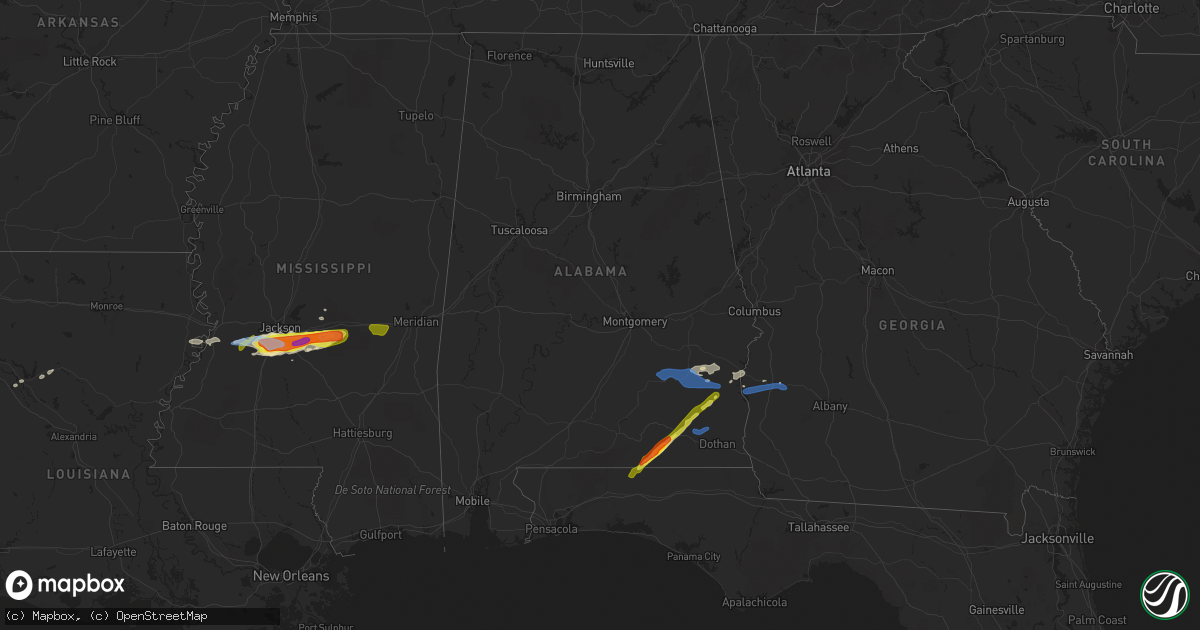
Hail Map in Alabama on March 4, 2020
Get this storm
March 4 map
$229
one time, instant access
Download today. No call, no setup
Keep the $229
Bought the map and want the full workflow? Apply the entire $229 to a subscription within 7 days. None of it is wasted.
Every map, not just this one
This buys you this map. Subscription and you get every map we run, in the markets you choose from a few cities to whole states to nationwide. Plus real-time alerts the moment a storm fires.
Contact data
Name, contact info, occupancy, even credit band for addresses in the footprint. You go from where it hit to who to call.
Become the source they trust
Unlimited branding weather history reports on demand. You already have the documented answer ready for the property owner, and you are the one who showed up with it.
Property data and RoofTrace estimates
Pull up any address you have got, its value and the exact code rules for that jurisdiction, straight from One Click Code. Then RoofTrace estimates the squares, pitch, and roof value, priced the way you price.
Storm reports in Alabama
Alabama
| Date | Description |
|---|---|
| 03/04/20209:08 AM CST | Corrects time of previous tstm wnd dmg report from 2 sw webb. Public report via facebook of a tree snapped along furnie folks road. |
| 03/04/20208:52 AM CST | Power lines down on county road 112 as well as a railroad crossing gate down. Trees down in this area as well. |
| 03/04/20208:45 AM CST | Several trees down and roof off home near newton. |
| 03/04/20208:20 AM CST | Reports of a tree on a car... Damage to houses and a sports complex... Multiple reports of trees down near new brockton and elba. |
| 03/04/20208:10 AM CST | Multiple trees and power lines down on belleville ave and evergreen ave in brewton. Few homes with roof damage. Time estimated by radar and report via social media. |
| 03/04/20208:08 AM CST | Public report via facebook of a tree snapped along furnie folks road. |
| 03/04/20207:56 AM CST | Multiple trees uprooted. Pictures via social media. |
| 03/04/20207:45 AM CST | Tree down on fort browder rd. Tree also down on fox ridge rd. Time estimated. |
| 03/04/20207:45 AM CST | Tree down on woodlawn dr. Time estimated. |
| 03/04/20207:45 AM CST | Tree down on corcoran rd. Time estimated. |
| 03/04/20207:25 AM CST | Corrects previous tstm wnd dmg report from 2 nnw texasville. Trees down on stark bros rd and also on bud gary rd. Time estimated. Corrected for day/time. |
| 03/04/20207:25 AM CST | Tree down on mary c smith rd. Time estimated. |
| 03/04/20207:18 AM CST | Several trees down along hwy 51 between clayton and louisville. Time estimated. |
| 03/04/20207:12 AM CST | Tree down on vacant mobile home near intersection of hwy 239 and cr 44. Trees also down in the vicinity near the intersections of cr 44 and 77 and cr 25 and hwy 239... |
| 03/04/20207:07 AM CST | Trees down on highway 29 in the perote community... And on highway 239 near the pea river... Causing the bridge to be closed. |
| 03/04/20207:04 AM CST | Tree down off cr-35 near us-82. Time estimated. |
| 03/04/20207:02 AM CST | Tree blocking highway 239 near barbour/bullock county line. Time estimated. |
| 03/04/20206:54 AM CST | Trees down on highway 29 south in perote community. Time estimated. |
| 03/04/20206:50 AM CST | Trees down on county road 8. |
| 03/04/20206:45 AM CST | Per the city of troy... Large tree and power pole down along pell ave... Resulting in power outages around troy university. |
| 03/04/20206:41 AM CST | 59mph wind gust recorded by toi asos at 641am. Multiple reports of trees on roadways near the city of troy and the airport. More details to come. |
| 03/04/20206:20 AM CST | Trees down near jordan rd and bradleyton rd. |
| 03/04/20206:05 AM CST | Several trees and a few power lines down in the highland home and panola areas. |
| 03/04/20206:01 AM CST | Corrects previous tstm wnd dmg report from 1 wsw sellers. Trees down on hickory grove rd... Near hwy 331 south. |
| 03/04/20205:45 AM CST | Report relayed via broadcast media on social media. |
| 03/04/20205:00 AM CST | Picture of quarter size hail on social media via wtvm. |
| 03/04/20204:45 AM CST | Corrects previous hail report time from 2 wsw hooper stage field. Report relayed via broadcast media on social media. |
| 03/04/20204:24 AM CST | A local report indicates 1.75 inch wind near SAMSON |
| 03/04/20202:50 AM CST | At 850 AM CST, severe thunderstorms were located along a line extending from 9 miles southwest of Abbeville to near Midland City to Pinckard, moving east at 45 mph. HAZARD...60 mph wind gusts. SOURCE...Radar indicated. IMPACT...Expect damage to roofs, siding, and trees. Locations impacted include... Headland, Dothan, Midland City, Kinsey, Cowarts, Newton, Webb, Pinckard, Grimes, Avon, Newville, Napier Field, Haleburg, Tumbleton, Kirkland Crossroads, Sigma, Grandberry Crossroads, Enon, Barber and Pleasant Plains. |
| 03/04/20202:36 AM CST | At 836 AM CST, severe thunderstorms were located along a line extending from 6 miles southwest of River Falls to 13 miles southwest of Andalusia to 18 miles east of East Brewton, moving east at 45 mph. HAZARD...60 mph wind gusts. SOURCE...Radar indicated. IMPACT...Expect damage to roofs, siding, and trees. Locations impacted include... Andalusia, Opp, River Falls and Heath. |
| 03/04/20202:27 AM CST | At 826 AM EST/726 AM CST/, Doppler radar indicated a line of severe thunderstorms capable of producing quarter size hail and damaging winds in excess of 60 mph. These storms were located along a line extending from Clayton to near Gaino to near Texasville to near Tyler Crossroads, and moving east at 50 mph. Locations impacted include... Fort Gaines, Georgetown, Walter F. George Lock And Dam, Wire Bridge, Walter F George Lake, Edwin, Standleys Store, Watson Crossroads, Scottsboro Crossroads, Double Bridges, Crossroads, Ricks Place, Pecan, Thomas Mill Creek, Hatcher, Morris, Jones Crossing, Bethel, Cotton Hill and Fort Gaines-Clay Airport. |
| 03/04/20201:54 AM CST | At 754 AM CST, severe thunderstorms were located along a line extending from Repton to 4 miles east of I65 And AL 113 to 7 miles northwest of Flomaton, moving east at 45 mph. HAZARD...60 mph wind gusts. SOURCE...Radar indicated. IMPACT...Expect damage to roofs, siding, and trees. Locations impacted include... Brewton, Evergreen, East Brewton, River Falls, Castleberry, Red Level, Repton, Riverview, I65 And US 84 and I65 And AL 113. |
| 03/04/202012:18 AM CST | At 617 AM CST, severe thunderstorms were located along a line extending from 12 miles south of Belknap to near Pine Apple to 8 miles east of Beatrice, moving east at 45 mph. HAZARD...60 mph wind gusts and quarter size hail. SOURCE...Radar indicated. IMPACT...Hail damage to vehicles is expected. Expect wind damage to roofs, siding, and trees. Locations impacted include... Greenville, Luverne, Rutledge, Glenwood, Pine Apple, Petrey and Highland Home. |
| 03/04/202012:14 AM CST | At 613 AM CST, severe thunderstorms were located along a line extending from 7 miles east of Waynesboro to 3 miles northwest of State Line to 11 miles west of Fruitdale, moving east at 50 mph. HAZARD...60 mph wind gusts and quarter size hail. SOURCE...Radar indicated. IMPACT...Hail damage to vehicles is expected. Expect wind damage to roofs, siding, and trees. Locations impacted include... Chatom, Saint Stephens, Wagarville, Leroy, Tibbie, Fruitdale and McIntosh. |
| 03/03/202011:55 PM CST | At 555 AM CST, a severe thunderstorm was located 8 miles south of Clara, or 13 miles northeast of Richton, moving southeast at 60 mph. HAZARD...70 mph wind gusts and half dollar size hail. SOURCE...Radar indicated. IMPACT...Hail damage to vehicles is expected. Expect considerable tree damage. Wind damage is also likely to mobile homes, roofs, and outbuildings. Locations impacted include... State Line and Buckatunna. |
| 03/03/202011:52 PM CST | At 552 AM CST, a severe thunderstorm was located 5 miles northeast of Vredenburgh, or 6 miles south of Camden, moving east at 40 mph. HAZARD...60 mph wind gusts and quarter size hail. SOURCE...Radar indicated. IMPACT...Hail damage to vehicles is expected. Expect wind damage to roofs, siding, and trees. Locations impacted include... Camden and Pine Apple. |
| 03/03/202011:32 PM CST | At 531 AM CST, a severe thunderstorm was located near Gordonville, or 7 miles southwest of Mosses, moving east at 50 mph. HAZARD...60 mph wind gusts and quarter size hail. SOURCE...Radar indicated. IMPACT...Hail damage to vehicles is expected. Expect wind damage to roofs, siding, and trees. Locations impacted include... Fort Deposit, Mosses, Hayneville, Meadville, Gordonville, Pine Level, Beechwood, Dublin, Grady, Sellers, Davenport, Ramer, Pintlala, Lowndes County Airport, Strata, Naftel, Logan, Sprague, Lapine and Calhoun. |
| 03/03/202011:31 PM CST | At 530 AM CST, a severe thunderstorm was located over Tuckers Crossing, or 6 miles southeast of Laurel, moving east at 55 mph. HAZARD...Golf ball size hail and 60 mph wind gusts. SOURCE...Radar indicated. IMPACT...People and animals outdoors will be injured. Expect hail damage to roofs, siding, windows, and vehicles. Expect wind damage to roofs, siding, and trees. Locations impacted include... Waynesboro, Clara and Buckatunna. |
| 03/03/202011:15 PM CST | At 514 AM CST, a severe thunderstorm was located over Thomasville, moving east at 40 mph. HAZARD...60 mph wind gusts and quarter size hail. SOURCE...Radar indicated. IMPACT...Hail damage to vehicles is expected. Expect wind damage to roofs, siding, and trees. Locations impacted include... Camden, Pine Hill and Yellow Bluff. |
| 03/03/202010:55 PM CST | At 455 AM CST, a severe thunderstorm was located 8 miles northeast of Coffeeville, or 16 miles west of Thomasville, moving east at 45 mph. HAZARD...60 mph wind gusts and quarter size hail. SOURCE...Radar indicated. IMPACT...Hail damage to vehicles is expected. Expect wind damage to roofs, siding, and trees. Locations impacted include... Thomasville. |
| 03/03/202010:20 PM CST | At 420 AM CST, a severe thunderstorm was located over Alamucha, or 8 miles southwest of Cuba, moving east at 50 mph. HAZARD...60 mph wind gusts. SOURCE...Radar indicated. IMPACT...Expect damage to roofs, siding, and trees. Locations impacted include... Cuba, Kinterbish, Bellamy, I 20 Welcome Center At Cuba, Ward and Whitfield. |
| 03/03/20209:57 PM CST | At 356 AM CST, a severe thunderstorm was located 8 miles north of Waynesboro, moving east at 45 mph. HAZARD...Ping pong ball size hail and 60 mph wind gusts. SOURCE...Radar indicated. IMPACT...People and animals outdoors will be injured. Expect hail damage to roofs, siding, windows, and vehicles. Expect wind damage to roofs, siding, and trees. Locations impacted include... Silas, Gilbertown and Toxey. |
| 03/03/20209:56 PM CST | At 355 AM CST, a severe thunderstorm was located over Meehan, or near Meridian, moving east at 55 mph. HAZARD...70 mph wind gusts and quarter size hail. SOURCE...Radar indicated. IMPACT...Hail damage to vehicles is expected. Expect considerable tree damage. Wind damage is also likely to mobile homes, roofs, and outbuildings. This severe thunderstorm will be near... Meridian and Savoy around 400 AM CST. Marion around 405 AM CST. Zero around 410 AM CST. Increase and Toomsuba around 415 AM CST. Alamucha around 420 AM CST. |
| 03/03/20209:18 PM CST | At 318 AM CST, a severe thunderstorm was located near Sandersville, or 6 miles northeast of Laurel, moving east at 40 mph. HAZARD...60 mph wind gusts and quarter size hail. SOURCE...Radar indicated. IMPACT...Hail damage to vehicles is expected. Expect wind damage to roofs, siding, and trees. Locations impacted include... Waynesboro. |
Cities Impacted by Hail Map on March 4, 2020
- Natchitoches, LA
- Hubbard, TX
- Coolidge, TX
- Mount Calm, TX
- Dawson, TX
- Ozark, AL
- Clio, AL
- Skipperville, AL
- Clopton, AL
- Morton, MS
- Florence, MS
- Pelahatchie, MS
- Braxton, MS
- Jackson, MS
- Pearl, MS
- Raymond, MS
- Raleigh, MS
- Terry, MS
- Richland, MS
- Byram, MS
- Pulaski, MS
- Brandon, MS
- Coffee Springs, AL
- Kinston, AL
- Samson, AL
- Cuthbert, GA
- Clayton, AL
- Midway, AL
- Keithville, LA
- Stonewall, LA
- Keatchie, LA
- Vicksburg, MS
- Newellton, LA
- Winnsboro, LA
- Gilbert, LA
- Jacksonville, TX
- Montgomery, TX
- Normangee, TX
- Madisonville, TX
- Defuniak Springs, FL
- Chancellor, AL
- Fort Rucker, AL
- Enterprise, AL
- Florala, AL
- Bryan, TX
- Georgetown, GA
- Eufaula, AL
- Laneville, TX
- Mount Enterprise, TX
- De Berry, TX
- Shreveport, LA
- Gary, TX
- Frierson, LA
- Tenaha, TX
- Gloster, LA
- Carthage, TX
- Crystal Springs, MS
- Cushing, TX
- Beckville, TX
- Henderson, TX
- Midway, TX
- Lovelady, TX
- Utica, MS
- Troup, TX
- Winnfield, LA
- Hearne, TX
- Palestine, TX
- Newton, MS
- Lawrence, MS
- Laurel Hill, FL
- Port Gibson, MS
- Forest, MS
- Lake, MS
- Mendenhall, MS
- Edwards, MS
- Fort Gaines, GA
- Ariton, AL
- Seguin, TX
- Broxton, GA
- Wray, GA
- Ambrose, GA
- Atlanta, LA
- Louisville, AL
- Crockett, TX
- Reklaw, TX
- Kingsbury, TX
- Banks, AL
- Elba, AL
- Long Branch, TX
- Willis, TX
- New Waverly, TX
- Brundidge, AL
- Troy, AL
- Shellman, GA
- Coleman, GA
- Morris, GA
- Midland City, AL
- Newton, AL
- Daleville, AL
- Hickory, MS


