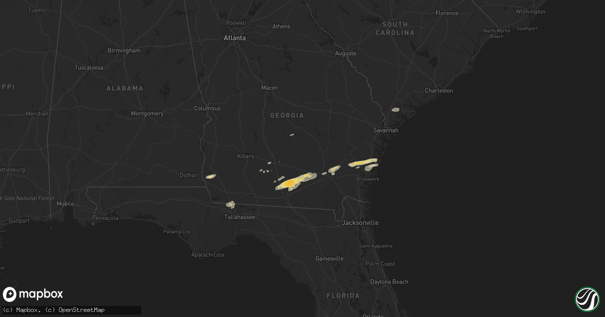
Hail Map in Georgia on March 3, 2012
Get this storm
March 3 map
$229
one time, instant access
Download today. No call, no setup
Keep the $229
Bought the map and want the full workflow? Apply the entire $229 to a subscription within 7 days. None of it is wasted.
Every map, not just this one
This buys you this map. Subscription and you get every map we run, in the markets you choose from a few cities to whole states to nationwide. Plus real-time alerts the moment a storm fires.
Contact data
Name, contact info, occupancy, even credit band for addresses in the footprint. You go from where it hit to who to call.
Become the source they trust
Unlimited branding weather history reports on demand. You already have the documented answer ready for the property owner, and you are the one who showed up with it.
Property data and RoofTrace estimates
Pull up any address you have got, its value and the exact code rules for that jurisdiction, straight from One Click Code. Then RoofTrace estimates the squares, pitch, and roof value, priced the way you price.
Storm reports in Georgia
Georgia
| Date | Description |
|---|---|
| 03/03/20121:28 PM CST | Tree down in the road at 1304 pinehurst ct. |
| 03/03/20121:20 PM CST | Ware county emergency manager reported trees down on powerlines in the sunnyside area. Time estimated from radar. |
| 03/03/20121:00 PM CST | Trained spotter reported quater size hail. |
| 03/03/201212:57 PM CST | A tree and a power line were blown down onto blues reach road. Time was estimated from radar. |
| 03/03/201212:40 PM CST | Tree down at 4800 block lori street. |
| 03/03/201212:40 PM CST | Ware county emergency manager reported trees down on powerlines in the millwood area. Time estimated from radar. |
| 03/03/201212:11 PM CST | Two mobile homes flipped. Power lines and trees down. Barn damaged. On beatty mill creek. |
| 03/03/201212:10 PM CST | Trees and power lines down near hwy 122 and hwy 37 |
| 03/03/201212:08 PM CST | Extensive roof damge to the hospital. Out buildings have damage. No power and gas leak. |
| 03/03/201212:08 PM CST | Roof damage to hospital and out buildings. No power and gas leak. |
| 03/03/201212:00 PM CST | Reports of homes off their foundations |
| 03/03/201212:00 PM CST | A number of medium size tree limbs were reported down and signs blown over. Time estimated based on radar. |
| 03/03/201212:00 PM CST | Report of homes off their foundations |
| 03/03/201212:00 PM CST | Two mobile homes flipped. Power lines and trees down. Barn damaged. On beatty mill creek. |
| 03/03/201211:55 AM CST | Trees were reported down near plant avenue and one large tree fell on a fence of a residence. Time of damage estimated from radar. |
| 03/03/201211:55 AM CST | Public estimated hail up to golf ball sized on bemiss rd north of moody afb. Most stones were quarter sized but a few were golf ball. |
| 03/03/201211:35 AM CST | Numerous power lines and trees down 7 miles north of dupont in northwest clinch county on tomlinson road near state roads 122 and 168. |
| 03/03/201211:22 AM CST | Trees and street signs reported down near cogdell highway. Funnel cloud also spotted but not certain it was touching ground. |
| 03/03/201210:40 AM CST | A tree was blown down onto a camper at 6941 pine circle. |
| 03/03/201210:25 AM CST | Roof blown off of a house and two irrigation pivots flipped. |
| 03/03/201210:18 AM CST | 2 trees down |
| 03/03/201210:04 AM CST | Law enforcement reported 1 tree down in rincon georgia. |
| 03/03/201210:04 AM CST | Trained spotter reported one tree down and several branches down in yard. Time estimated by radar. |
| 03/03/20129:53 AM CST | Law enforcement reported 1 tree down near the intersection of little mccall road and mockingbird lane. |
| 03/03/20129:53 AM CST | Fire department reported one tree down on a house and two trees snapped in half along shirley drive. |
| 03/03/20129:44 AM CST | A few trees were blown down around boston. |
| 03/03/20129:06 AM CST | Ema reported powerlines down in west green. |
| 03/03/20129:00 AM CST | Ema reports straight line winds with structure damage to commercial building with 1/4 of a roof taken off. Some damage to a few homes. Trees and powerlines reported dow |
| 03/03/20128:25 AM CST | A few trees were blown down along spruce road. |
| 03/03/20127:55 AM CST | Trees reported down at 2100 spence rd. |
| 03/03/20127:39 AM CST | Trees and power lines down. Possible tornado. |
| 03/03/20127:36 AM CST | Possible tornado. Damage confirmed. |
| 03/03/20127:35 AM CST | Trees reported down at 2100 spence rd. |
| 03/03/20127:30 AM CST | An nws survey confirmed an ef0 tornado touched down near vada road and moved northeastward around 3.37 miles with intermittent damage before lifting near 31.07n and 84. |
| 03/03/20127:15 AM CST | Roof blown off of a house and two irrigation pivots flipped. |
| 03/03/20126:20 AM CST | Nws storm survey confirms an ef0 briefly touched down on cooktown road. Damage to one home with the tin roof and front porch torn off. Several pine trees were also snap |
All States Impacted by Hail Map on March 3, 2012
Cities Impacted by Hail Map on March 3, 2012
- Tifton, GA
- Valdosta, GA
- Pearson, GA
- Barney, GA
- Millwood, GA
- Quitman, GA
- Ray City, GA
- Axson, GA
- Moody Afb, GA
- Adel, GA
- Morven, GA
- Willacoochee, GA
- Lakeland, GA
- Homerville, GA
- Manor, GA
- Nashville, GA
- Naylor, GA
- Hahira, GA
- Darien, GA
- Patterson, GA
- Blackshear, GA
- Brunswick, GA
- Sapelo Island, GA
- Ty Ty, GA
- Townsend, GA
- Blakely, GA
- Doerun, GA
- Moultrie, GA
- Hortense, GA
- Jesup, GA
- Quincy, FL
- Attapulgus, GA
- Havana, FL
- Norman Park, GA
- Donalsonville, GA
- Colquitt, GA
- Jakin, GA
- Ridgeland, SC
- Rhine, GA
- Milan, GA
- Omega, GA
- Waycross, GA


