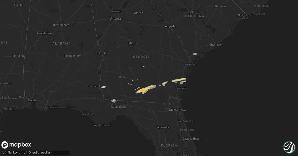
Hail Map in Florida on March 3, 2012
Get this storm
March 3 map
$229
one time, instant access
Download today. No call, no setup
Keep the $229
Bought the map and want the full workflow? Apply the entire $229 to a subscription within 7 days. None of it is wasted.
Every map, not just this one
This buys you this map. Subscription and you get every map we run, in the markets you choose from a few cities to whole states to nationwide. Plus real-time alerts the moment a storm fires.
Contact data
Name, contact info, occupancy, even credit band for addresses in the footprint. You go from where it hit to who to call.
Become the source they trust
Unlimited branding weather history reports on demand. You already have the documented answer ready for the property owner, and you are the one who showed up with it.
Property data and RoofTrace estimates
Pull up any address you have got, its value and the exact code rules for that jurisdiction, straight from One Click Code. Then RoofTrace estimates the squares, pitch, and roof value, priced the way you price.
Storm reports in Florida
Florida
| Date | Description |
|---|---|
| 03/03/20122:15 PM CST | Residents near the jefferson/brooks county line report trees down near highway 221. Reported obtained from wtxl news article. Time of event estimated by radar. |
| 03/03/20121:45 PM CST | Tree and power line down on tram road. |
| 03/03/20121:40 PM CST | Tree down on house |
| 03/03/20121:40 PM CST | Tree down on house. |
| 03/03/20128:25 AM CST | 20-25 trees down no structual damage. |
| 03/03/20128:25 AM CST | 20-25 trees down. Witness claims he saw a tornado. |
| 03/03/20128:04 AM CST | A tree was blown down onto a power line near 5437 stricklin road. |
| 03/03/20127:36 AM CST | At state road 267 and 1 mile south past old federal road a tree was reported down. |
| 03/03/20127:25 AM CST | A large tree was blown down on highway 177. |
| 03/03/20124:20 AM CST | Several trees down at 1191 south county road 3 in pierson. |
| 03/03/20124:15 AM CST | Tree on house and car on south moore st. In bunnell. |
| 03/03/20124:10 AM CST | Portion of roof on apartment building torn off and one large tree next to building snapped off. Apartment complex located near the intersection of busch blvd and armeni |
| 03/03/20123:40 AM CST | A power line and a few tree limbs reported down. |
| 03/03/20123:15 AM CST | Pool screen destroyed and stop sign bent near the corner of westwinds dr and cardinal trail. |
All States Impacted by Hail Map on March 3, 2012
Cities Impacted by Hail Map on March 3, 2012
- Tifton, GA
- Valdosta, GA
- Pearson, GA
- Barney, GA
- Millwood, GA
- Quitman, GA
- Ray City, GA
- Axson, GA
- Moody Afb, GA
- Adel, GA
- Morven, GA
- Willacoochee, GA
- Lakeland, GA
- Homerville, GA
- Manor, GA
- Nashville, GA
- Naylor, GA
- Hahira, GA
- Darien, GA
- Patterson, GA
- Blackshear, GA
- Brunswick, GA
- Sapelo Island, GA
- Ty Ty, GA
- Townsend, GA
- Blakely, GA
- Doerun, GA
- Moultrie, GA
- Hortense, GA
- Jesup, GA
- Quincy, FL
- Attapulgus, GA
- Havana, FL
- Norman Park, GA
- Donalsonville, GA
- Colquitt, GA
- Jakin, GA
- Ridgeland, SC
- Rhine, GA
- Milan, GA
- Omega, GA
- Waycross, GA


