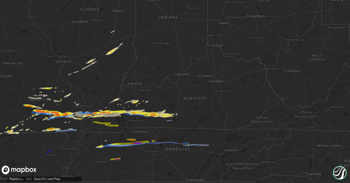
Hail Map in Kentucky on March 2, 2020
Get this storm
March 2 map
$229
one time, instant access
Download today. No call, no setup
Keep the $229
Bought the map and want the full workflow? Apply the entire $229 to a subscription within 7 days. None of it is wasted.
Every map, not just this one
This buys you this map. Subscription and you get every map we run, in the markets you choose from a few cities to whole states to nationwide. Plus real-time alerts the moment a storm fires.
Contact data
Name, contact info, occupancy, even credit band for addresses in the footprint. You go from where it hit to who to call.
Become the source they trust
Unlimited branding weather history reports on demand. You already have the documented answer ready for the property owner, and you are the one who showed up with it.
Property data and RoofTrace estimates
Pull up any address you have got, its value and the exact code rules for that jurisdiction, straight from One Click Code. Then RoofTrace estimates the squares, pitch, and roof value, priced the way you price.
Storm reports in Kentucky
Kentucky
| Date | Description |
|---|---|
| 03/02/20205:57 PM CST | Reported in downtown paducah. Relayed via twitter. Time estimated by radar. |
| 03/02/20205:49 PM CST | Time estimated from radar. Relayed via twitter. |
| 03/02/20205:19 PM CST | A local report indicates 1.00 inch wind near KEVIL |
| 03/02/20205:15 PM CST | Report relayed via twitter. Time estimated. |
| 03/02/20205:10 AM CST | At 1110 PM CST, a severe thunderstorm was located near East Prairie, moving east at 50 mph. HAZARD...60 mph wind gusts and quarter size hail. SOURCE...Radar indicated. IMPACT...Hail damage to vehicles is expected. Expect wind damage to roofs, siding, and trees. Locations impacted include... Charleston, East Prairie, Miner, Wyatt, Anniston and Wilson City. This includes the following highways... Interstate 57 in Missouri between Mile Markers 2 and 3, and betweenMile Markers 10 and 11. Interstate 55 between Mile Markers 57 and 66. |
| 03/02/20203:58 AM CST | At 958 PM CST, a severe thunderstorm was located over Plum Springs, moving east at 35 mph. HAZARD...60 mph wind gusts and quarter size hail. SOURCE...Radar indicated. IMPACT...Hail damage to vehicles is expected. Expect wind damage to roofs, siding, and trees. Locations impacted include... Bowling Green, Plum Springs, Crestmoor, Memphis Junction, Mount Victor, Smiths Grove, Oakland, Bristow, Hardcastle and Pondsville. |
| 03/02/20203:30 AM CST | At 930 PM CST, a severe thunderstorm was located 8 miles north of Bowling Green, moving east at 45 mph. HAZARD...60 mph wind gusts and quarter size hail. SOURCE...Radar indicated. IMPACT...Hail damage to vehicles is expected. Expect wind damage to roofs, siding, and trees. Locations impacted include... Bowling Green, Brownsville, Smiths Grove, Oakland, Chalybeate, Girkin, Rockland, Tuckertown, Straw and Asphalt. |
| 03/02/20203:04 AM CST | At 904 PM CST, severe thunderstorms were located along a line extending from near Tamms to near Horseshoe Lake Conservation Area to near Bertrand, moving east at 55 mph. HAZARD...60 mph wind gusts and quarter size hail. SOURCE...Radar indicated. IMPACT...Hail damage to vehicles is expected. Expect wind damage to roofs, siding, and trees. Locations impacted include... Charleston, Cairo, La Center, Miner, Bardwell, Wickliffe, Bertrand, Mounds, Barlow, Tamms, Mound City, Wyatt, Olive Branch, Horseshoe Lake Conservation Area, Ullin, Kevil, Olmsted, Arlington, New Grand Chain and Pulaski.This includes the following highways... Interstate 57 in Illinois between Mile Markers 1 and 19. Interstate 57 in Missouri between Mile Markers 3 and 21. Interstate 55 between Mile Markers 68 and 71. |
| 03/02/20203:02 AM CST | At 902 PM CST, a severe thunderstorm was located 12 miles south of Morgantown, moving east at 45 mph. HAZARD...60 mph wind gusts and half dollar size hail. SOURCE...Radar indicated. IMPACT...Hail damage to vehicles is expected. Expect wind damage to roofs, siding, and trees. Locations impacted include... Bowling Green, Plum Springs, Crestmoor, Memphis Junction, Mount Victor, Dimple, Leetown, Rockland, Buffalo Fork and Sharer. |
| 03/02/20202:00 AM CST | A tree was blown down. |
| 03/02/20201:13 AM CST | At 713 PM CST, a severe thunderstorm was located over Princeton, moving east at 30 mph. HAZARD...60 mph wind gusts and quarter size hail. SOURCE...Radar indicated. IMPACT...Hail damage to vehicles is expected. Expect wind damage to roofs, siding, and trees. Locations impacted include... Princeton, Dawson Springs, Farmersville and Hawkins. This includes Interstate 69 in Kentucky between Mile Markers 74 and98. |
| 03/02/202012:23 AM CST | Multiple trees down near cemetery road and shockley road. |
| 03/02/202012:17 AM CST | Multiple trees down... Significant roof damage to two homes. |
| 03/02/202012:15 AM CST | Ef-2 tornado that had an overall path length of 2.2 miles as it traveled into far northwest allen county. At its widest point it was 250 yards and it was on the ground |
| 03/01/202011:45 PM CST | Viewer report...with pictures...of a large tree uprooted along with some structural damage. Time approximated from radar and viewers estimate. |
| 03/01/202010:05 PM CST | A local report indicates 1.00 inch wind near 2 ESE PLUM SPRINGS |
| 03/01/20209:57 PM CST | A local report indicates 1.00 inch wind near PLUM SPRINGS |
| 03/01/20209:50 PM CST | Report from mping: quarter |
| 03/01/20209:46 PM CST | Report from mping: 1-inch tree limbs broken; shingles blown off. |
| 03/01/20209:35 PM CST | A local report indicates 1.00 inch wind near HANSON |
| 03/01/20209:17 PM CST | Near davis crossroads. Hail up to quarter size... But dime size hail covering ground. |
| 03/01/20208:02 PM CST | Tornado witnessed by meteorologist just south of crofton. Carport destroyed. Possible roof and sign damage. |
| 03/01/20208:02 PM CST | A local report indicates 1.00 inch wind near 1 S CROFTON |
| 03/01/20208:00 PM CST | Nws storm survey found an ef-1 tornado with estimated peak winds of 90 mph occurred south of crofton. The tornado began at 800 pm and ended at 806 pm. The maximum torna |
| 03/01/20207:05 PM CST | . |
| 03/01/20206:55 PM CST | New marina was moved 20 feet by thunderstorm winds. A boat docked in the marina was damaged. Time estimated by radar. |
| 03/01/20206:40 PM CST | A local report indicates 1.00 inch wind near EDDYVILLE |
Cities Impacted by Hail Map on March 2, 2020
- Newton, IL
- Wheeler, IL
- Mason, IL
- Ingraham, IL
- Farina, IL
- Louisville, IL
- Dieterich, IL
- Crofton, KY
- Dawson Springs, KY
- White Plains, KY
- Greenville, KY
- Nortonville, KY
- Elkton, KY
- Hopkinsville, KY
- Saint Charles, KY
- Cumberland Furnace, TN
- Vanleer, TN
- Dickson, TN
- Manila, AR
- Leachville, AR
- Cerulean, KY
- Kuttawa, KY
- Princeton, KY
- Ledbetter, KY
- Fredonia, KY
- Calvert City, KY
- Tiline, KY
- Lewisburg, KY
- Morgantown, KY
- Marion, KY
- Oakland, KY
- Paducah, KY
- Smithland, KY
- Metropolis, IL
- Sharon Grove, KY
- West Paducah, KY
- Dunmor, KY
- Bowling Green, KY
- Grand Rivers, KY
- Gilbertsville, KY
- Eddyville, KY
- Smiths Grove, KY
- Brookport, IL
- Russellville, KY
- Wickliffe, KY
- Auburn, KY
- La Center, KY
- Rockfield, KY
- Barlow, KY
- Belton, KY
- Roundhill, KY
- Kevil, KY
- Cave In Rock, IL
- Elizabethtown, IL
- Cape Girardeau, MO
- Jackson, MO
- Perryville, MO
- Caulfield, MO
- Pottersville, MO
- Carlyle, IL
- Sandoval, IL
- Centralia, IL
- Gepp, AR
- Winona, MO
- Dudley, MO
- Bloomfield, MO
- Mill Spring, MO
- Sturdivant, MO
- Wappapello, MO
- Ellington, MO
- Williamsville, MO
- Greenville, MO
- Puxico, MO
- Piedmont, MO
- Ellsinore, MO
- Zalma, MO
- McGee, MO
- Advance, MO
- Van Buren, MO
- Eminence, MO
- Brownwood, MO
- Gainesville, MO
- Odin, IL
- Doniphan, MO
- Neelyville, MO
- Harviell, MO
- Poplar Bluff, MO
- Naylor, MO
- Oxly, MO
- Manitou, KY
- Hanson, KY
- Madisonville, KY
- Cairo, IL
- Sikeston, MO
- Charleston, MO
- Steelville, MO
- Belgrade, MO
- Potosi, MO
- Mineral Point, MO
- Irondale, MO
- Bismarck, MO
- Vanduser, MO
- Brownsville, KY
- Scott City, MO
- Bell City, MO
- Chaffee, MO
- Essex, MO
- Benton, MO
- Fremont, MO
- Park City, KY
- Benton, KY
- Bertrand, MO
- Oran, MO
- Miller City, IL
- Pomona, MO
- West Plains, MO
- Bakersfield, MO
- Gamaliel, AR
- Ironton, MO
- Annapolis, MO
- Lesterville, MO
- Rosiclare, IL
- Patton, MO
- Arcadia, MO
- Fredericktown, MO
- Grandin, MO
- Dyer, TN
- Trenton, TN
- Bradford, TN
- Monette, AR
- Bixby, MO
- White Bluff, TN
- Burns, TN
- Salem, MO
- Nebo, KY
- Millersville, MO
- Burfordville, MO
- Yale, IL
- Hidalgo, IL
- Okawville, IL
- Nashville, IL
- Addieville, IL
- Patoka, IL
- Thayer, MO
- Koshkonong, MO
- Bon Aqua, TN
- Big Sandy, TN
- Parma, MO
- Campbell, MO
- Malden, MO
- Gleason, TN
- Dresden, TN
- Atwood, TN
- Viola, AR
- Doe Run, MO
- Park Hills, MO
- Clarkridge, AR
- Udall, MO
- Island, KY
- Central City, KY
- Centertown, KY
- Red Bud, IL
- Birch Tree, MO
- Hollow Rock, TN
- Huntingdon, TN
- Mansfield, TN
- Bruceton, TN
- McKenzie, TN
- Providence, KY
- Slaughters, KY
- Clay, KY
- Dixon, KY
- Henderson, AR
- Black, MO
- Belleview, MO
- Golconda, IL
- Redford, MO
- Moody, MO
- Glasgow, KY
- Cave City, KY
- Myrtle, MO
- Oakland, AR
- Yellville, AR
- Mattoon, IL
- Boss, MO
- Hartshorn, MO
- Salem, KY
- New Athens, IL
- Marissa, IL
- Lenzburg, IL
- Sturkie, AR
- Hoyleton, IL
- Salem, IL
- Couch, MO
- Dexter, MO
- Farmington, MO
- Hampton, KY
- Gatewood, MO
- Sainte Genevieve, MO
- Mountain Home, AR
- Erin, TN
- Bunker, MO
- McEwen, TN
- Ashland City, TN
- Henry, TN
- Waverly, TN
- Charlotte, TN
- Eva, TN
- Camden, TN
- Tennessee Ridge, TN
- Stewart, TN
- Cumberland City, TN
- Nashville, TN
- Whites Creek, TN
- Huron, TN
- Lexington, TN
- Darden, TN
- Parsons, TN
- Cookeville, TN
- Bono, AR
- Jonesboro, AR
- Lancing, TN
- Deer Lodge, TN
- Crossville, TN
- Mound City, IL
- Alvaton, KY
- Scottsville, KY
- Patterson, MO
- Zanoni, MO
- Caledonia, MO
- Fairdealing, MO
- Bardwell, KY
- Kirksey, KY
- Fancy Farm, KY
- Arlington, KY
- Mayfield, KY
- Clinton, KY
- Dexter, KY
- Farmington, KY
- Almo, KY
- Murray, KY
- Mount Juliet, TN
- Gordonsville, TN
- Kingston Springs, TN
- Greenfield, TN
- Milan, TN
- Pegram, TN
- Brush Creek, TN
- Lebanon, TN
- Watertown, TN
- Hickman, TN
- Hermitage, TN
- Buffalo Valley, TN
- Baxter, TN
- Silver Point, TN
- Monterey, TN
- Mounds, IL
- Lilbourn, MO
- Catron, MO
- Qulin, MO


