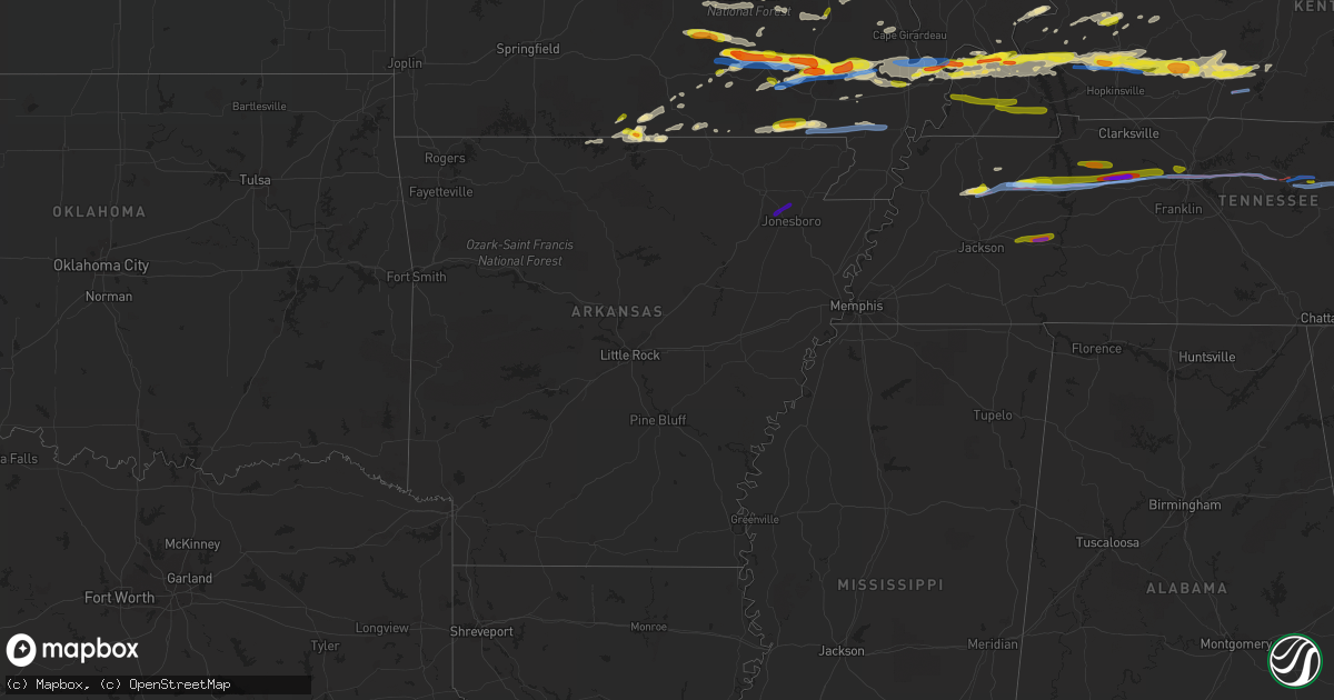
Hail Map in Arkansas on March 2, 2020
Get this storm
March 2 map
$229
one time, instant access
Download today. No call, no setup
Keep the $229
Bought the map and want the full workflow? Apply the entire $229 to a subscription within 7 days. None of it is wasted.
Every map, not just this one
This buys you this map. Subscription and you get every map we run, in the markets you choose from a few cities to whole states to nationwide. Plus real-time alerts the moment a storm fires.
Contact data
Name, contact info, occupancy, even credit band for addresses in the footprint. You go from where it hit to who to call.
Become the source they trust
Unlimited branding weather history reports on demand. You already have the documented answer ready for the property owner, and you are the one who showed up with it.
Property data and RoofTrace estimates
Pull up any address you have got, its value and the exact code rules for that jurisdiction, straight from One Click Code. Then RoofTrace estimates the squares, pitch, and roof value, priced the way you price.
Storm reports in Arkansas
Arkansas
| Date | Description |
|---|---|
| 03/02/20205:56 AM CST | At 1155 PM CST, a severe thunderstorm was located near Swifton, or 13 miles northeast of Newport, moving east at 45 mph. HAZARD...60 mph wind gusts and quarter size hail. SOURCE...Radar indicated. IMPACT...Hail damage to vehicles is expected. Expect wind damage to roofs, siding, and trees. Locations impacted include... Jonesboro, Paragould, Bono, Lake City, Bay, Brookland, Cash, Egypt, Hergett, Apt, Valley View, Schug, Gum Point, Farrville, Dorothy, Lester, Winesburg, Bethel, Lache Lake and Herndon. |
| 03/02/20201:05 AM CST | Golfball size hail just outside of leachville. |
| 03/02/202012:30 AM CST | Hail up to the size of quarters along highway 351. |
| 03/02/202012:16 AM CST | Pea to quarter size hail |
Cities Impacted by Hail Map on March 2, 2020
- Newton, IL
- Wheeler, IL
- Mason, IL
- Ingraham, IL
- Farina, IL
- Louisville, IL
- Dieterich, IL
- Crofton, KY
- Dawson Springs, KY
- White Plains, KY
- Greenville, KY
- Nortonville, KY
- Elkton, KY
- Hopkinsville, KY
- Saint Charles, KY
- Cumberland Furnace, TN
- Vanleer, TN
- Dickson, TN
- Manila, AR
- Leachville, AR
- Cerulean, KY
- Kuttawa, KY
- Princeton, KY
- Ledbetter, KY
- Fredonia, KY
- Calvert City, KY
- Tiline, KY
- Lewisburg, KY
- Morgantown, KY
- Marion, KY
- Oakland, KY
- Paducah, KY
- Smithland, KY
- Metropolis, IL
- Sharon Grove, KY
- West Paducah, KY
- Dunmor, KY
- Bowling Green, KY
- Grand Rivers, KY
- Gilbertsville, KY
- Eddyville, KY
- Smiths Grove, KY
- Brookport, IL
- Russellville, KY
- Wickliffe, KY
- Auburn, KY
- La Center, KY
- Rockfield, KY
- Barlow, KY
- Belton, KY
- Roundhill, KY
- Kevil, KY
- Cave In Rock, IL
- Elizabethtown, IL
- Cape Girardeau, MO
- Jackson, MO
- Perryville, MO
- Caulfield, MO
- Pottersville, MO
- Carlyle, IL
- Sandoval, IL
- Centralia, IL
- Gepp, AR
- Winona, MO
- Dudley, MO
- Bloomfield, MO
- Mill Spring, MO
- Sturdivant, MO
- Wappapello, MO
- Ellington, MO
- Williamsville, MO
- Greenville, MO
- Puxico, MO
- Piedmont, MO
- Ellsinore, MO
- Zalma, MO
- McGee, MO
- Advance, MO
- Van Buren, MO
- Eminence, MO
- Brownwood, MO
- Gainesville, MO
- Odin, IL
- Doniphan, MO
- Neelyville, MO
- Harviell, MO
- Poplar Bluff, MO
- Naylor, MO
- Oxly, MO
- Manitou, KY
- Hanson, KY
- Madisonville, KY
- Cairo, IL
- Sikeston, MO
- Charleston, MO
- Steelville, MO
- Belgrade, MO
- Potosi, MO
- Mineral Point, MO
- Irondale, MO
- Bismarck, MO
- Vanduser, MO
- Brownsville, KY
- Scott City, MO
- Bell City, MO
- Chaffee, MO
- Essex, MO
- Benton, MO
- Fremont, MO
- Park City, KY
- Benton, KY
- Bertrand, MO
- Oran, MO
- Miller City, IL
- Pomona, MO
- West Plains, MO
- Bakersfield, MO
- Gamaliel, AR
- Ironton, MO
- Annapolis, MO
- Lesterville, MO
- Rosiclare, IL
- Patton, MO
- Arcadia, MO
- Fredericktown, MO
- Grandin, MO
- Dyer, TN
- Trenton, TN
- Bradford, TN
- Monette, AR
- Bixby, MO
- White Bluff, TN
- Burns, TN
- Salem, MO
- Nebo, KY
- Millersville, MO
- Burfordville, MO
- Yale, IL
- Hidalgo, IL
- Okawville, IL
- Nashville, IL
- Addieville, IL
- Patoka, IL
- Thayer, MO
- Koshkonong, MO
- Bon Aqua, TN
- Big Sandy, TN
- Parma, MO
- Campbell, MO
- Malden, MO
- Gleason, TN
- Dresden, TN
- Atwood, TN
- Viola, AR
- Doe Run, MO
- Park Hills, MO
- Clarkridge, AR
- Udall, MO
- Island, KY
- Central City, KY
- Centertown, KY
- Red Bud, IL
- Birch Tree, MO
- Hollow Rock, TN
- Huntingdon, TN
- Mansfield, TN
- Bruceton, TN
- McKenzie, TN
- Providence, KY
- Slaughters, KY
- Clay, KY
- Dixon, KY
- Henderson, AR
- Black, MO
- Belleview, MO
- Golconda, IL
- Redford, MO
- Moody, MO
- Glasgow, KY
- Cave City, KY
- Myrtle, MO
- Oakland, AR
- Yellville, AR
- Mattoon, IL
- Boss, MO
- Hartshorn, MO
- Salem, KY
- New Athens, IL
- Marissa, IL
- Lenzburg, IL
- Sturkie, AR
- Hoyleton, IL
- Salem, IL
- Couch, MO
- Dexter, MO
- Farmington, MO
- Hampton, KY
- Gatewood, MO
- Sainte Genevieve, MO
- Mountain Home, AR
- Erin, TN
- Bunker, MO
- McEwen, TN
- Ashland City, TN
- Henry, TN
- Waverly, TN
- Charlotte, TN
- Eva, TN
- Camden, TN
- Tennessee Ridge, TN
- Stewart, TN
- Cumberland City, TN
- Nashville, TN
- Whites Creek, TN
- Huron, TN
- Lexington, TN
- Darden, TN
- Parsons, TN
- Cookeville, TN
- Bono, AR
- Jonesboro, AR
- Lancing, TN
- Deer Lodge, TN
- Crossville, TN
- Mound City, IL
- Alvaton, KY
- Scottsville, KY
- Patterson, MO
- Zanoni, MO
- Caledonia, MO
- Fairdealing, MO
- Bardwell, KY
- Kirksey, KY
- Fancy Farm, KY
- Arlington, KY
- Mayfield, KY
- Clinton, KY
- Dexter, KY
- Farmington, KY
- Almo, KY
- Murray, KY
- Mount Juliet, TN
- Gordonsville, TN
- Kingston Springs, TN
- Greenfield, TN
- Milan, TN
- Pegram, TN
- Brush Creek, TN
- Lebanon, TN
- Watertown, TN
- Hickman, TN
- Hermitage, TN
- Buffalo Valley, TN
- Baxter, TN
- Silver Point, TN
- Monterey, TN
- Mounds, IL
- Lilbourn, MO
- Catron, MO
- Qulin, MO


