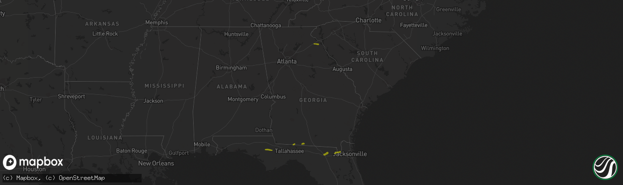
Hail Map in Georgia on March 1, 2019
The weather event in Georgia on March 1, 2019 includes Hail map. 2 states and 35 cities were impacted and suffered possible damage. The total estimated number of properties impacted is 1,697.
Want more than just the map?
Turn this storm into a full workflow.
- Owner + property data so you know who to knock
- OnDemand branded weather history reports to win the "did we even have hail?" argument
- RoofTrace estimate so reps stop guessing numbers at the door
Bought this map? Upgrade within 7 days and we'll credit the $230. (10-15 min setup call)
Hail
1,697
Estimated number of impacted properties by a 1.00" hail or larger0
Estimated number of impacted properties by a 1.75" hail or larger0
Estimated number of impacted properties by a 2.50" hail or largerStorm reports in Georgia
Georgia
| Date | Description |
|---|---|
| 03/01/20193:04 PM CST | Several trees and powerlines down near 3844 wiley rd... 3852 berkshire ridge dr... And casper dr. Also some minor roof damage to a barn near wiley rd and some siding da |
| 03/01/201912:58 PM CST | A tree reported down along sr-121 near mile marker 7 |
| 03/01/201910:58 AM CST | Tree reported down along highway 129 near mile marker 13. Time of event estimated. |
| 03/01/20196:27 AM CST | At 1227 PM EST, severe thunderstorms were located along a line extending from 15 miles south of Quitman to 11 miles west of Madison to 16 miles north of Perry, moving east at 50 mph. HAZARD...60 mph wind gusts. SOURCE...Radar indicated. IMPACT...Expect damage to roofs, siding, and trees. Locations impacted include... Madison, Greenville, Lee, Moseley Hall, Ebb, Hopewell, Cherry Lake, Hamburg, Hanson, Pinetta and Sirmans. |
| 03/01/20196:26 AM CST | At 1226 PM EST, a severe thunderstorm was located 10 miles south of Homerville, moving east at 35 mph. HAZARD...60 mph wind gusts and quarter size hail. SOURCE...Radar indicated. IMPACT...Hail damage to vehicles is expected. Expect wind damage to roofs, siding, and trees. Locations impacted include... Stephen Foster State Park. |
| 03/01/20196:01 AM CST | At 1201 PM EST, a severe thunderstorm was located near Mayday, or 10 miles northeast of Statenville, moving east at 40 mph. HAZARD...60 mph wind gusts and quarter size hail. SOURCE...Radar indicated. IMPACT...Hail damage to vehicles is expected. Expect wind damage to roofs, siding, and trees. This severe thunderstorm will remain over mainly rural areas of north central Echols and west central Clinch Counties. |
| 03/01/20194:45 AM CST | At 1045 AM EST, a severe thunderstorm was located 8 miles north of Monticello, moving east at 35 mph. HAZARD...60 mph wind gusts and nickel size hail. SOURCE...Radar indicated. IMPACT...Expect damage to roofs, siding, and trees. Locations impacted include... Monticello, Quitman, Boston, Alma, Dixie, Dills, Grooverville, Cherry Lake, Everett, Hamburg, Pidcock, Lovett, Nankin, Empress, Brooks Co A/p, Blue Springs, Ashville and Jarrott. |
| 02/28/201910:54 PM CST | At 453 PM EST, a severe thunderstorm was located 6 miles west of Hartwell, or near Bowersville, moving east at 25 mph. HAZARD...60 mph wind gusts and quarter size hail. SOURCE...Radar indicated. IMPACT...Minor hail damage to vehicles is expected. Expect wind damage to trees and power lines. Locations impacted include... Hartwell, Reed Creek, Bowersville, Rock Branch, Nuberg, Sadlers Creek State Park, Royston, Lake Hartwell and Canon. |
| 02/28/20198:33 PM CST | At 233 PM EST, severe thunderstorms were located along a line extending from 7 miles southwest of Kingsland to 7 miles southeast of Sanderson, moving east at 40 mph. HAZARD...60 mph wind gusts and quarter size hail. SOURCE...Radar indicated. IMPACT...Hail damage to vehicles is expected. Expect wind damage to roofs, siding, and trees. Locations impacted include... Jacksonville, St. Marys, Kingsland, Fernandina Beach, Hilliard, Callahan, Jacksonville International Arpt, Unf, Kings Bay Base and Arlington. |
| 02/28/20198:09 PM CST | At 209 PM EST, a severe thunderstorm was located 7 miles north of Glen St. Mary, or 21 miles north of Raiford, moving northeast at 35 mph. HAZARD...60 mph wind gusts and quarter size hail. SOURCE...Radar indicated. IMPACT...Hail damage to vehicles is expected. Expect wind damage to roofs, siding, and trees. Locations impacted include... Callahan, Macclenny, Nassau Village-Ratliff, St. George, Ratliff and Bryceville. |
| 02/28/20197:56 PM CST | At 156 PM EST, a severe thunderstorm was located 10 miles northeast of Winfield, or 12 miles northeast of Lake City, moving northeast at 40 mph. HAZARD...60 mph wind gusts and quarter size hail. SOURCE...Radar indicated. IMPACT...Hail damage to vehicles is expected. Expect wind damage to roofs, siding, and trees. Locations impacted include... Taylor. |
Cities Impacted by Hail Map on March 1, 2019
- Thomasville, GA
- Tallahassee, FL
- Quitman, GA
- Dixie, GA
- Lake City, FL
- White Springs, FL
- Bryceville, FL
- Sanderson, FL
- Saint George, GA
- Glen Saint Mary, FL
- Macclenny, FL
- Clarksville, FL
- Altha, FL
- Blountstown, FL
- Bowersville, GA
- Carnesville, GA
- Canon, GA
- Lavonia, GA
- Fountain, FL
- Monticello, FL
- Boston, GA
- Quincy, FL
- Du Pont, GA
- Statenville, GA
- Lake Park, GA
- Stockton, GA
- Fargo, GA
- Valdosta, GA
- Hosford, FL
- Marianna, FL
- Alford, FL
- Youngstown, FL
- Chipley, FL
- Wewahitchka, FL
- Naylor, GA


