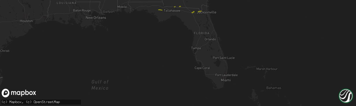
Hail Map in Florida on March 1, 2019
The weather event in Florida on March 1, 2019 includes Hail map. 2 states and 35 cities were impacted and suffered possible damage. The total estimated number of properties impacted is 3,227.
Want more than just the map?
Turn this storm into a full workflow.
- Owner + property data so you know who to knock
- OnDemand branded weather history reports to win the "did we even have hail?" argument
- RoofTrace estimate so reps stop guessing numbers at the door
Bought this map? Upgrade within 7 days and we'll credit the $230. (10-15 min setup call)
Hail
3,227
Estimated number of impacted properties by a 1.00" hail or larger0
Estimated number of impacted properties by a 1.75" hail or larger0
Estimated number of impacted properties by a 2.50" hail or largerStorm reports in Florida
Florida
| Date | Description |
|---|---|
| 03/01/20193:43 PM CST | Palm coast fire department passed on a report of several trees down near royal palms and belle terre parkway in palm coast. |
| 03/01/20192:00 PM CST | Tree fell and damaged a fence in the millhopper subdivision. Time was estimated based on radar. |
| 03/01/201912:33 PM CST | Social media relayed a photo of quarter size hail in white springs. Time estimated by radar. |
| 03/01/201911:47 AM CST | Fallen trees or limbs resulted in a power outage to 704 customers along sw state route 14. Report via duke energy outage map. |
| 03/01/20199:50 AM CST | Penny to quarter size hail along fulford road about 2 miles east of highway 19. |
| 03/01/20194:50 AM CST | Estimated on the road between blountstown and altha. |
| 03/01/20194:21 AM CST | At 1020 AM EST, a severe thunderstorm was located 12 miles northwest of Monticello, moving east at 40 mph. HAZARD...60 mph wind gusts and quarter size hail. SOURCE...Radar indicated. IMPACT...Hail damage to vehicles is expected. Expect wind damage to roofs, siding, and trees. Locations impacted include... Monticello, Alma, Fincher, Festus, Lois, Everett, Miccosukee, Moccasin Gap, Casa Blanco, Jarrott, Montivilla, Metcalf and Lake Miccosukee. |
| 03/01/20194:20 AM CST | Several trees were snapped at the base. |
| 03/01/20194:20 AM CST | Report of golf ball size hail in northwest calhoun county. |
| 02/28/201910:23 PM CST | At 422 PM EST, a severe thunderstorm was located near Andalusia, moving east at 30 mph. HAZARD...60 mph wind gusts and penny size hail. SOURCE...Radar indicated. IMPACT...Expect damage to roofs, siding, and trees. Locations impacted include... Palm Coast, Flagler Beach, Bunnell, Marineland, Crescent Beach, Beverly Beach and Espanola. |
| 02/28/20197:23 PM CST | At 122 PM EST, a severe thunderstorm was located over Wellborn, or 8 miles southwest of White Springs, moving northeast at 25 mph. HAZARD...60 mph wind gusts. SOURCE...Radar indicated. IMPACT...Expect damage to roofs, siding, and trees. Locations impacted include... Lake City, White Springs, Wellborn, Five Points, Winfield and Suwannee Valley. |
Cities Impacted by Hail Map on March 1, 2019
- Thomasville, GA
- Tallahassee, FL
- Quitman, GA
- Dixie, GA
- Lake City, FL
- White Springs, FL
- Bryceville, FL
- Sanderson, FL
- Saint George, GA
- Glen Saint Mary, FL
- Macclenny, FL
- Clarksville, FL
- Altha, FL
- Blountstown, FL
- Bowersville, GA
- Carnesville, GA
- Canon, GA
- Lavonia, GA
- Fountain, FL
- Monticello, FL
- Boston, GA
- Quincy, FL
- Du Pont, GA
- Statenville, GA
- Lake Park, GA
- Stockton, GA
- Fargo, GA
- Valdosta, GA
- Hosford, FL
- Marianna, FL
- Alford, FL
- Youngstown, FL
- Chipley, FL
- Wewahitchka, FL
- Naylor, GA


