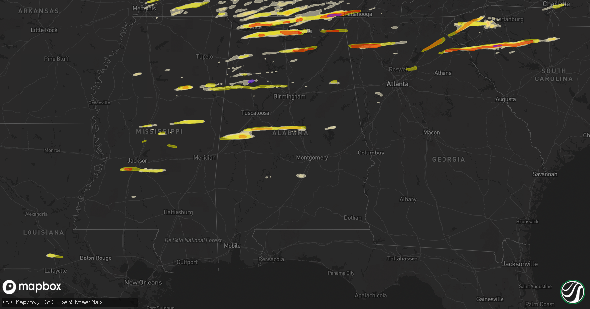
Hail Map in Alabama on March 1, 2017
Get this storm
March 1 map
$229
one time, instant access
Download today. No call, no setup
Keep the $229
Bought the map and want the full workflow? Apply the entire $229 to a subscription within 7 days. None of it is wasted.
Every map, not just this one
This buys you this map. Subscription and you get every map we run, in the markets you choose from a few cities to whole states to nationwide. Plus real-time alerts the moment a storm fires.
Contact data
Name, contact info, occupancy, even credit band for addresses in the footprint. You go from where it hit to who to call.
Become the source they trust
Unlimited branding weather history reports on demand. You already have the documented answer ready for the property owner, and you are the one who showed up with it.
Property data and RoofTrace estimates
Pull up any address you have got, its value and the exact code rules for that jurisdiction, straight from One Click Code. Then RoofTrace estimates the squares, pitch, and roof value, priced the way you price.
Storm reports in Alabama
Alabama
| Date | Description |
|---|---|
| 03/01/20175:57 PM CST | Clarke county 911 has reports of multiple trees down on campbells landing rd. |
| 03/01/20175:44 PM CST | Trees downed onto powerlines in wind creek state park; pea- to dime-sized hail also fell. |
| 03/01/20174:56 PM CST | Quarter-sized hail reported. |
| 03/01/20174:40 PM CST | Section of wooden yard fence panels and posts blown down. |
| 03/01/20174:37 PM CST | Tree downed. |
| 03/01/20174:08 PM CST | A few trees... Power lines downed in the area. |
| 03/01/20174:06 PM CST | Trees... Power lines downed. |
| 03/01/20174:06 PM CST | Tree downed onto powerlines. |
| 03/01/20173:49 PM CST | Tree down on cr 137 near violet hill. |
| 03/01/20173:47 PM CST | Quarter-sized hail reported in the gardendale area. |
| 03/01/20173:46 PM CST | Barn damage on county road 50 near fyffe. |
| 03/01/20173:40 PM CST | Tree and power lines down on bakers chapel road. |
| 03/01/20173:37 PM CST | . |
| 03/01/20173:33 PM CST | Trees downed in a few areas. |
| 03/01/20173:30 PM CST | Trees downed. |
| 03/01/20173:21 PM CST | A lot of quarter-sized hail falling along i-22 in cordova. . |
| 03/01/20172:52 PM CST | Trees down at willow lake and burroughs dr. |
| 03/01/20172:49 PM CST | Trees down on a house on burroughs loop. |
| 03/01/20172:43 PM CST | Power lines and trees down near quarry rd. And union grove rd. |
| 03/01/20172:41 PM CST | . |
| 03/01/20172:30 PM CST | One inch hail was reported. |
| 03/01/20172:30 PM CST | Windows broken out by golf ball hail near hwy 431 and claysville school and the airport. |
| 03/01/20172:27 PM CST | Quarter-sized hail reported. |
| 03/01/20172:24 PM CST | Penny- to quarter-sized hail reported. |
| 03/01/20172:20 PM CST | Quarter size hail and 56 mph wind gust in hebron. |
| 03/01/20172:13 PM CST | In ryan crossroads area--location approximate. Relayed via local news media. |
| 03/01/20172:04 PM CST | Quarter-sized hail reported in winfield. |
| 03/01/20172:01 PM CST | Nickel-sized hail with a few quarters mixed in. |
| 03/01/20172:00 PM CST | Quarter-sized hail reported in winfield. |
| 03/01/20171:35 PM CST | . |
| 03/01/20171:30 PM CST | Half dollar sized hail in creekwood subdivision near creekwood park in huntsville. |
| 03/01/20171:30 PM CST | Near the corner of whitesburg and drake. |
| 03/01/20171:28 PM CST | Observed at nws office/uah cramer hall/swirll. 40 mph wind also observed by uah mips. |
| 03/01/20171:23 PM CST | 50 mph winds also reported. |
| 03/01/20171:23 PM CST | Tree reported down across al241. |
| 03/01/20171:21 PM CST | Metal community center building and batting cages damaged near the intersection of us 231 and carriger rd. |
| 03/01/20171:13 PM CST | Report of quarter-sized hail along al241 near bear creek. |
| 03/01/20171:13 PM CST | Dime- to quarter-sized hail reported in bear creek. |
| 03/01/20171:07 PM CST | Roof damage and trees down near ready section road at pulaski pike. Shed also damaged in this area. |
| 03/01/20171:05 PM CST | Delayed report from mar-1 storms: limestone county ema relayed a report from a deputy of quarter size hail near the intersection of brownsferry rd and cowford rd. |
| 03/01/20171:01 PM CST | . |
| 03/01/20171:00 PM CST | Relayed via social media. |
| 03/01/201712:52 PM CST | . |
| 03/01/201712:50 PM CST | . |
| 03/01/201712:42 PM CST | . |
| 03/01/201712:42 PM CST | . |
| 03/01/201712:35 PM CST | . |
| 03/01/201712:25 PM CST | . |
| 03/01/201712:19 PM CST | . |
| 03/01/201712:06 PM CST | Relayed via social media. |
| 03/01/201712:00 PM CST | . |
| 03/01/201711:57 AM CST | . |
| 03/01/201710:58 AM CST | Emergency manager reports two trees blown down near pinehill. One fell onto a home. |
| 02/28/20176:16 PM CST | Emergency manager reports two trees blown down near pinehill. One fell onto a home. |
All States Impacted by Hail Map on March 1, 2017
Cities Impacted by Hail Map on March 1, 2017
- Ball Ground, GA
- Canton, GA
- Pickens, MS
- Smiths Grove, KY
- Brownsville, KY
- Clinton, SC
- Laurens, SC
- Sallis, MS
- Mantee, MS
- Mathiston, MS
- Bellefontaine, MS
- Eupora, MS
- Maben, MS
- West Point, MS
- Columbus, MS
- Ardmore, TN
- Taft, TN
- Prospect, TN
- Kannapolis, NC
- Lincolnton, NC
- Bessemer City, NC
- Iron Station, NC
- Mount Holly, NC
- Davidson, NC
- Concord, NC
- Rockwell, NC
- Stanley, NC
- Dallas, NC
- Alexis, NC
- Huntersville, NC
- Courtland, AL
- Town Creek, AL
- Leighton, AL
- Tuscumbia, AL
- Ethel, MS
- Kosciusko, MS
- Louisville, MS
- Macon, MS
- Noxapater, MS
- McCool, MS
- Alexander City, AL
- Jacksons Gap, AL
- Statesville, NC
- Harmony, NC
- Olin, NC
- Mocksville, NC
- Greenville, SC
- Liberty, SC
- Salem, SC
- Pickens, SC
- Central, SC
- Easley, SC
- Taylors, SC
- Seneca, SC
- Six Mile, SC
- Blackstock, SC
- Great Falls, SC
- Lancaster, SC
- Heath Springs, SC
- Michie, TN
- Counce, TN
- Tullahoma, TN
- Manchester, TN
- Altamont, TN
- Pelham, TN
- Prairie, MS
- Hamilton, MS
- Aberdeen, MS
- Caledonia, MS
- Savannah, TN
- Shiloh, TN
- Sawyerville, AL
- Boligee, AL
- Eutaw, AL
- Blanchester, OH
- Clarksville, OH
- Morrow, OH
- Gruetli Laager, TN
- Hillsboro, TN
- Coalmont, TN
- Estill Springs, TN
- Tracy City, TN
- Washington, NC
- Waynesboro, TN
- South Pittsburg, TN
- Jasper, TN
- Sherwood, TN
- Guin, AL
- Winfield, AL
- Randleman, NC
- Climax, NC
- Lexington, NC
- Pleasant Garden, NC
- Franklinville, NC
- Staley, NC
- High Point, NC
- Sophia, NC
- Trinity, NC
- Liberty, NC
- Thomasville, NC
- Greensboro, NC
- Julian, NC
- Snow Camp, NC
- Florence, AL
- Brent, AL
- Moundville, AL
- Mountville, SC
- Kinards, SC
- Joanna, SC
- Fayetteville, TN
- Dellrose, TN
- Gardendale, AL
- Graysville, AL
- Dora, AL
- Hickory, NC
- Conover, NC
- Walhalla, SC
- Quinton, AL
- Charlotte, NC
- College Grove, TN
- Olivehill, TN
- Hohenwald, TN
- Clifton, TN
- Franklin, TN
- Nolensville, TN
- Ethridge, TN
- Lawrenceburg, TN
- Vardaman, MS
- Charleston, MS
- Cleveland, NC
- Catawba, NC
- Claremont, NC
- Stony Point, NC
- Centreville, AL
- Gurley, AL
- Carnesville, GA
- Columbia, TN
- Eagleville, TN
- Chapel Hill, TN
- Lewisburg, TN
- Goodman, MS
- Lexington, MS
- Waterloo, SC
- Hodges, SC
- Fayette, AL
- Kennedy, AL
- Vernon, AL
- Millport, AL
- Dadeville, AL
- Berry, AL
- Alexandria, TN
- Liberty, TN
- Dowelltown, TN
- Watertown, TN
- Auburntown, TN
- Morton, MS
- Brandon, MS
- Mendenhall, MS
- Braxton, MS
- Raleigh, MS
- Florence, MS
- Whitwell, TN
- Decherd, TN
- Newnan, GA
- Huntsville, AL
- Shelbyville, TN
- Tremont, MS
- Saint Joseph, TN
- Iron City, TN
- Loretto, TN
- Advance, NC
- Woodleaf, NC
- Cooleemee, NC
- Russellville, AL
- Madison, AL
- Hillsboro, AL
- Tanner, AL
- Athens, AL
- Trinity, AL
- Brownsboro, AL
- Owens Cross Roads, AL
- Decatur, AL
- Carthage, MS
- Memphis, TN
- Leoma, TN
- Goodspring, TN
- Killen, AL
- Five Points, TN
- Minor Hill, TN
- Anderson, AL
- Rogersville, AL
- Hackleburg, AL
- Hamilton, AL
- Muscle Shoals, AL
- Lester, AL
- Elkmont, AL
- Honea Path, SC
- Belton, SC
- Ware Shoals, SC
- Donalds, SC
- Whitmire, SC
- Hazel Green, AL
- New London, NC
- Denton, NC
- Greer, SC
- Starr, SC
- Richburg, SC
- Carlisle, SC
- Bowersville, GA
- Chester, SC
- Union, SC
- Hartwell, GA
- Blair, SC
- Winnsboro, SC
- Anderson, SC
- Iva, SC
- Adairsville, GA
- Calhoun, GA
- Sulligent, AL
- Phil Campbell, AL
- Bear Creek, AL
- Double Springs, AL
- Graham, NC
- Opelousas, LA
- Church Point, LA
- Camden, AL
- Pikeville, KY
- Sidney, KY
- Tamassee, SC
- Somerville, TN
- La Grange, TN
- Hornsby, TN
- Hickory Valley, TN
- Bethel Springs, TN
- Middleton, TN
- Saulsbury, TN
- Williston, TN
- Grand Junction, TN
- Whiteville, TN
- Bolivar, TN
- Moscow, TN
- Mauldin, SC
- Simpsonville, SC
- Ellijay, GA
- Cherry Log, GA
- Pulaski, TN
- Lynnville, TN
- Union Grove, AL
- Eva, AL
- Falkville, AL
- Hartselle, AL
- Somerville, AL
- Tutwiler, MS
- Jemison, AL
- Thorsby, AL
- Randolph, AL
- Rome, GA
- Armuchee, GA
- Lavonia, GA
- Crouse, NC
- Decatur, TN
- Lascassas, TN
- Huntland, TN
- Toney, AL
- Belvidere, TN
- Stevenson, AL
- New Market, AL
- Estillfork, AL
- Ardmore, AL
- Sequatchie, TN
- Coffeeville, MS
- Bruce, MS
- Thomaston, GA
- Molena, GA
- Meansville, GA
- Rossville, GA
- Burlington, NC
- Hildebran, NC
- Linwood, NC
- Salisbury, NC
- Jasper, AL
- Shelby, NC
- Lawndale, NC
- Cherryville, NC
- Rockvale, TN
- Murfreesboro, TN
- Alexandria, AL
- Weaver, AL
- Anniston, AL
- Jacksonville, AL
- Cypress Inn, TN
- West Union, SC
- Sunset, SC
- Fort Deposit, AL
- Monteagle, TN
- Beersheba Springs, TN
- Mcminnville, TN
- Petersburg, TN
- Maplesville, AL
- Lawley, AL
- Clanton, AL
- Akron, AL
- Arley, AL
- Addison, AL
- Sontag, MS
- Brookhaven, MS
- Beaverton, AL
- Alto, GA
- Baileyton, AL
- Woodruff, SC
- Travelers Rest, SC
- Marietta, SC
- Mountain Rest, SC
- Piedmont, SC
- Westminster, SC
- Troy, NC
- Mount Gilead, NC
- Candor, NC
- Biscoe, NC
- Albemarle, NC
- Star, NC
- Morrison, TN
- Gainesville, AL
- Epes, AL
- Greensboro, AL
- Forrest City, AR
- Valdese, NC
- Morganton, NC
- Scottsboro, AL
- Cornersville, TN
- Kelso, TN
- Lutts, TN
- Lexington, AL
- Waterloo, AL
- Westpoint, TN
- Winchester, TN
- Frankewing, TN
- Mulberry, TN
- Kimberly, AL
- Pinson, AL
- Warrior, AL
- Mebane, NC
- Chapel Hill, NC
- Winston Salem, NC
- Asheboro, NC
- Connelly Springs, NC
- Bankston, AL
- Oakman, AL
- Pleasant Plain, OH
- Oregonia, OH
- Meridianville, AL
- Ranger, GA
- Fairmount, GA
- Letohatchee, AL
- Dickson, TN
- Bon Aqua, TN
- Nunnelly, TN
- Bath Springs, TN
- Linden, TN
- Collinwood, TN
- Dunlap, TN
- Danville, AL
- Brentwood, TN
- Weogufka, AL
- Arlington, TN
- Forkland, AL
- Emelle, AL
- Cedarbluff, MS
- Carbon Hill, AL
- Nauvoo, AL
- Old Fort, TN
- Milton, TN
- Seagrove, NC
- Goshen, OH
- Loveland, OH
- Talking Rock, GA
- Burnsville, MS
- Selmer, TN
- Corinth, MS
- Clover, SC
- Belmont, NC
- Odenville, AL
- McDonald, TN
- Cleveland, TN
- Elora, TN
- Bridgeport, AL
- Sewanee, TN
- Cherokee, AL
- Flintville, TN
- Harvest, AL
- Heth, AR
- Proctor, AR
- Northport, AL
- Fountain Inn, SC
- Gray Court, SC
- Culleoka, TN
- Canon, GA
- Commerce, GA
- Detroit, AL
- Crane Hill, AL
- Bremen, AL
- McEwen, TN
- Lyles, TN
- Cordova, AL
- Parrish, AL
- Only, TN
- Waverly, TN
- Burns, TN
- Hurricane Mills, TN
- Port Allen, LA
- Terry, MS
- Raymond, MS
- Utica, MS
- Crump, TN
- Adamsville, TN
- Morris Chapel, TN
- Belfast, TN
- Wartrace, TN
- Mount Pleasant, NC
- Kings Mountain, NC
- Holly Pond, AL
- Cullman, AL
- Lynchburg, TN
- Eldridge, AL
- Douglasville, GA
- Whitesburg, GA
- Winston, GA
- Palmetto, GA
- Unionville, TN
- Duncan, SC
- Lyman, SC
- Millington, TN
- Pinetown, NC
- Toxey, AL
- Smyrna, TN
- Fairview, TN
- Arab, AL
- Guntersville, AL
- Nashville, TN
- Antioch, TN
- Cornelius, NC
- Richfield, NC
- Gold Hill, NC
- Summerville, GA
- Dahlonega, GA
- Marble Hill, GA
- Dawsonville, GA
- Jasper, GA
- Plainville, GA
- Lebanon, OH
- Haleyville, AL
- Hodges, AL
- Olive Branch, MS
- Moulton, AL
- Vinemont, AL
- Houston, AL
- Grandview, TN
- Widener, AR
- Mount Pleasant, TN
- Benton, MS
- Salyersville, KY
- Pikeville, NC
- Goldsboro, NC
- Siler City, NC
- Bear Creek, NC
- Bennett, NC
- Ramseur, NC
- Cowan, TN
- Palmer, TN
- Fulton, MS
- Wesson, MS
- Niota, TN
- Annville, KY
- Guild, TN
- Whiteside, TN
- Lupton City, TN
- Signal Mountain, TN
- Chattanooga, TN
- Joppa, AL
- Grant, AL
- Langston, AL
- Valley Head, AL
- Ider, AL
- Menlo, GA
- Rising Fawn, GA
- Flat Rock, AL
- Hollywood, AL
- Pisgah, AL
- Steens, MS
- Mount Olive, AL
- Townley, AL
- Sumiton, AL
- Eagle Springs, NC
- Lebanon, TN
- Monterey, TN
- Hico, WV
- Lansing, WV
- Victor, WV
- Nallen, WV
- Quinwood, WV
- Rainelle, WV
- Canton, MS
- Camden, MS
- Byram, MS
- Union, MS
- Lena, MS
- Sebastopol, MS
- Walnut Grove, MS
- Forest, MS
- Lyerly, GA
- Cornelia, GA
- Toccoa, GA
- Lula, GA
- Gainesville, GA
- Mount Airy, GA
- Baldwin, GA
- Martin, GA
- Homer, GA
- Duluth, GA
- Suwanee, GA
- Alpharetta, GA
- Buford, GA
- Lawrenceville, GA
- Arnaudville, LA
- Port Barre, LA
- Cadiz, KY
- Herndon, KY
- Gracey, KY
- Pembroke, KY
- Hopkinsville, KY
- Indian Mound, TN
- Big Sandy, TN
- Greenbrier, TN
- Chapmansboro, TN
- Adairville, KY
- White House, TN
- Westmoreland, TN
- Cottontown, TN
- Portland, TN
- Palmyra, TN
- Cross Plains, TN
- Ashland City, TN
- Franklin, KY
- Dover, TN
- Clarksville, TN
- Springville, TN
- Orlinda, TN
- Elkton, KY
- Allensville, KY
- Scottsville, KY
- Fort Campbell, KY
- Olmstead, KY
- Pleasant View, TN
- Cedar Hill, TN
- Buchanan, TN
- Cumberland City, TN
- Oak Grove, KY
- Russellville, KY
- Guthrie, KY
- Stewart, TN
- Tennessee Ridge, TN
- Adolphus, KY
- Cunningham, TN
- Springfield, TN
- Woodlawn, TN
- Trenton, KY
- Adams, TN
- Big Rock, TN
- Hendersonville, TN
- Castalian Springs, TN
- Gallatin, TN
- Madison, TN
- Whites Creek, TN
- Goodlettsville, TN
- Kingston Springs, TN
- Charlotte, TN
- Southside, TN
- Erin, TN
- Hermitage, TN
- Mount Juliet, TN
- Pegram, TN
- Joelton, TN
- White Bluff, TN
- Vanleer, TN
- Cumberland Furnace, TN
- Old Hickory, TN
- Lancaster, TN
- Silver Point, TN
- Baxter, TN
- Smithville, TN
- La Vergne, TN
- Cookeville, TN
- Chestnut Mound, TN
- Centerville, TN
- Buffalo Valley, TN
- Primm Springs, TN
- Elmwood, TN
- Bloomington Springs, TN
- Carthage, TN
- Brush Creek, TN
- Sparta, TN
- Hickman, TN
- Gordonsville, TN
- Duck River, TN
- Bowling Green, KY


