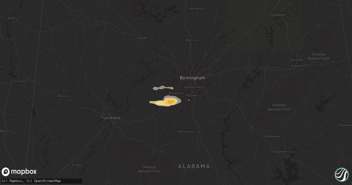
Hail Map in Bessemer, AL on March 1, 2016
Get this storm
March 1 map
$229
one time, instant access
Download today. No call, no setup
Keep the $229
Bought the map and want the full workflow? Apply the entire $229 to a subscription within 7 days. None of it is wasted.
Every map, not just this one
This buys you this map. Subscription and you get every map we run, in the markets you choose from a few cities to whole states to nationwide. Plus real-time alerts the moment a storm fires.
Contact data
Name, contact info, occupancy, even credit band for addresses in the footprint. You go from where it hit to who to call.
Become the source they trust
Unlimited branding weather history reports on demand. You already have the documented answer ready for the property owner, and you are the one who showed up with it.
Property data and RoofTrace estimates
Pull up any address you have got, its value and the exact code rules for that jurisdiction, straight from One Click Code. Then RoofTrace estimates the squares, pitch, and roof value, priced the way you price.
Storm reports in Bessemer, AL
Bessemer, AL
| Date | Description |
|---|---|
| 03/01/20165:50 PM CST | Tree down blocking road. Corrected time. End point of nws storm survey. |
| 03/01/20165:49 PM CST | Trees down blocking roadway. Time estimated by radar. |
| 03/01/20165:49 PM CST | Tree reported down. Tin off of roof and tree limbs reported in the vicinity. Time estimated by radar. |
| 03/01/20165:49 PM CST | Tree reported down. Tin off of roof and tree limbs reported in the vicinity. Time estimated by radar. Updated event type. |
| 03/01/20165:48 PM CST | Cedar tree down... Estimated 20 to 30 inch diameter. Time estimated. Corrected diameter. |
| 03/01/20165:46 PM CST | Report of trees and power lines down. Road impassable. Corrected time. |
| 03/01/20165:45 PM CST | Tree reported down. Updated event type. |
| 03/01/20165:45 PM CST | Tree reported down. |
| 03/01/20165:44 PM CST | Significant damage reported at bent brook golf course. Possible damage to vehicles. Several trees down. County road 52 blocked by downed trees. Time estimated by radar. |
| 03/01/20165:43 PM CST | Significant damage reported at bent brook golf course. Possible damage to vehicles. Several trees down. County road 52 blocked by downed trees. Time estimated by radar. |
| 03/01/20165:43 PM CST | Tree down blocking road. Time estimated by radar. |
| 03/01/20165:43 PM CST | Report of four residents injured. Updated information according to jefferson county ema. Corrected time. |
| 03/01/20165:43 PM CST | Tree damage reported. Corrected time. Updated information. |
| 03/01/20165:42 PM CST | *** 4 inj *** report of four residents injured. Updated information according to jefferson county ema. Time estimated by radar. |
| 03/01/20165:42 PM CST | Report of trees and power lines down. Road impassable. |
| 03/01/20165:42 PM CST | Tree damage reported. Time estimated by radar. |
All States Impacted by Hail Map on March 1, 2016
All Cities Impacted by Hail Map on March 1, 2016
- Wisner, LA
- Fort Necessity, LA
- Winnsboro, LA
- Columbia, LA
- Grayson, LA
- Pollock, LA
- Trout, LA
- McCalla, AL
- Birmingham, AL
- Adger, AL
- Bessemer, AL
- Brookwood, AL
- State Line, MS
- Georgetown, LA
- Dry Prong, LA
- Jena, LA
- Vance, AL
- Tullos, LA
- Winnfield, LA
- Dodson, LA
- Sikes, LA
- Olla, LA
- Livingston, TN
- Alpine, TN
- Monroe, TN
- Jonesville, LA
- Harrisonburg, LA
- Marion Junction, AL
- Selma, AL
- Columbus, IN
- Sicily Island, LA
- Maynardville, TN
- Rickman, TN
- Hilham, TN
- Cookeville, TN
- Jamestown, TN
- Byrdstown, TN
- Pall Mall, TN
- Adamsville, AL


