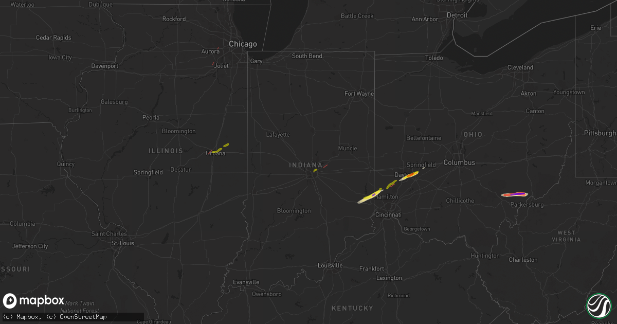
Hail Map in Indiana on February 27, 2023
Get this storm
February 27 map
$229
one time, instant access
Download today. No call, no setup
Keep the $229
Bought the map and want the full workflow? Apply the entire $229 to a subscription within 7 days. None of it is wasted.
Every map, not just this one
This buys you this map. Subscription and you get every map we run, in the markets you choose from a few cities to whole states to nationwide. Plus real-time alerts the moment a storm fires.
Contact data
Name, contact info, occupancy, even credit band for addresses in the footprint. You go from where it hit to who to call.
Become the source they trust
Unlimited branding weather history reports on demand. You already have the documented answer ready for the property owner, and you are the one who showed up with it.
Property data and RoofTrace estimates
Pull up any address you have got, its value and the exact code rules for that jurisdiction, straight from One Click Code. Then RoofTrace estimates the squares, pitch, and roof value, priced the way you price.
Storm reports in Indiana
Indiana
| Date | Description |
|---|---|
| 02/27/20231:58 PM CST | Delayed report. A few trees downed and some roof damage to a residence. Time estimated from radar. Report relayed to nws by wane tv. |
| 02/27/20231:55 PM CST | Tree down at west jefferson and homestead road. |
| 02/27/20231:55 PM CST | Tree down in the area of us 24 and redding drive. |
| 02/27/20231:50 PM CST | Roof damage near churubusco. Report of a metal roof blowing off of a commercial structure on us 33 at the allen/whitley county border. No injuries. Parts of the metal r |
| 02/27/20231:40 PM CST | Delayed report. A few trees downed. Some shingle damage and siding damage to a residence. Time estimated from radar. |
| 02/27/20231:33 PM CST | 1 to 3 inch in diameter limbs blown down. Some of the limbs had rot in them. Time estimated by radar. |
| 02/27/20231:20 PM CST | Photo verified. |
| 02/27/20231:09 PM CST | Photo verified. |
| 02/27/20231:02 PM CST | Report from mping: 1-inch tree limbs broken; shingles blown off. |
| 02/27/202312:53 PM CST | Trees and powerlines blown down. |
| 02/27/202312:53 PM CST | Trees and powerlines blown down. |
| 02/27/202312:53 PM CST | Trees and powerlines down. |
| 02/27/202312:50 PM CST | Trees and powerlines down across northern sections of the county. |
| 02/27/202312:49 PM CST | A local report indicates 59 MPH wind near 3 SSW KEMPTON |
| 02/27/202312:45 PM CST | Report from mping: 3-inch tree limbs broken; power poles broken. |
| 02/27/202312:40 PM CST | Collapsed barn. Reported via social media. Time estimated via radar. |
| 02/27/202312:35 PM CST | Trees and power lines downed. Reported by county ema. Time estimated via radar. |
| 02/27/202312:35 PM CST | Late report of second ef-1 tornado with estimated 100 mph peak winds. 0.30 mile long track. 50 yards maximum width. |
| 02/27/202312:28 PM CST | Late report of ef-1 tornado with estimated 110 mph peak winds. 3.34 mile long track. 50 yards maximum width. |
| 02/27/202312:25 PM CST | Power lines sheared. Twitter post and pictures. Time and duration estimated. |
| 02/27/202312:21 PM CST | Report from mping: 1-inch tree limbs broken; shingles blown off. |
| 02/27/202312:05 PM CST | Report of nickel to quarter size hail falling 7.5 miles west of rochester on state road 14 in western fulton county... In. |
| 02/27/202311:06 AM CST | Potential tornado damage. Outbuildings with roof damage. Time estimated from radar imagery. |
Cities Impacted by Hail Map on February 27, 2023
- Champaign, IL
- Urbana, IL
- Saint Joseph, IL
- Ogden, IL
- Penfield, IL
- Indianapolis, IN
- Mccordsville, IN
- Fortville, IN
- Brookville, IN
- Cedar Grove, IN
- Oxford, OH
- Hamilton, OH
- Joliet, IL
- Somerville, OH
- Trenton, OH
- Middletown, OH
- Camden, OH
- Germantown, OH
- Plainfield, IL
- Naperville, IL
- Lebanon, OH
- Dayton, OH
- Oregonia, OH
- Waynesville, OH
- Xenia, OH
- Fairborn, OH
- Yellow Springs, OH
- Okeana, OH
- Batesville, IN
- Sunman, IN
- Miamisburg, OH
- Millfield, OH
- Amesville, OH
- Chesterhill, OH
- Cutler, OH
- Stockport, OH
- Vincent, OH
- Waterford, OH
- Fleming, OH
- Marietta, OH
- Athens, OH
- Springfield, OH


