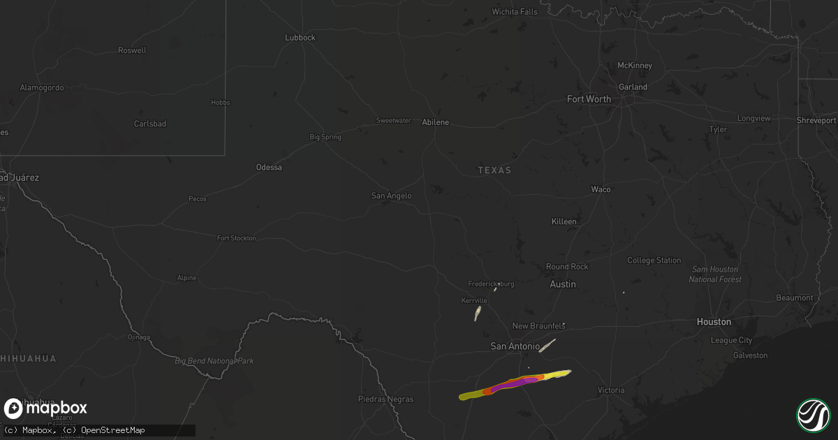
Hail Map in Texas on February 25, 2018
Get this storm
February 25 map
$229
one time, instant access
Download today. No call, no setup
Keep the $229
Bought the map and want the full workflow? Apply the entire $229 to a subscription within 7 days. None of it is wasted.
Every map, not just this one
This buys you this map. Subscription and you get every map we run, in the markets you choose from a few cities to whole states to nationwide. Plus real-time alerts the moment a storm fires.
Contact data
Name, contact info, occupancy, even credit band for addresses in the footprint. You go from where it hit to who to call.
Become the source they trust
Unlimited branding weather history reports on demand. You already have the documented answer ready for the property owner, and you are the one who showed up with it.
Property data and RoofTrace estimates
Pull up any address you have got, its value and the exact code rules for that jurisdiction, straight from One Click Code. Then RoofTrace estimates the squares, pitch, and roof value, priced the way you price.
Storm reports in Texas
Texas
| Date | Description |
|---|---|
| 02/25/20186:45 AM CST | Public reported 1 inch hail observed. |
| 02/25/20186:35 AM CST | Karnes electric co-op reported power lines down. |
| 02/25/20186:32 AM CST | Thunderstorm winds blew over a grain bin and some yard fixtures. Time estimated with radar. |
| 02/25/20186:20 AM CST | Local public reported ping pong sized hail. |
| 02/25/20186:10 AM CST | A local report indicates 1.00 inch wind near FALLS CITY |
| 02/25/201812:43 AM CST | At 642 AM CST, a severe thunderstorm was located over Cestohowa, or near Kosciusko, moving east at 35 mph. HAZARD...60 mph wind gusts and half dollar size hail. SOURCE...Radar indicated. IMPACT...Hail damage to vehicles is expected. Expect wind damage to roofs, siding, and trees. Locations impacted include... Yorktown, Kosciusko, Cestohowa, Gillett, Cotton Patch, Gruenau, New Davy, Ecleto, Paweleville, Helena and Pana Maria. |
| 02/25/201812:10 AM CST | At 610 AM CST, a severe thunderstorm was located 13 miles southwest of Poth, moving east at 35 mph. HAZARD...Ping pong ball size hail and 60 mph wind gusts. SOURCE...Radar indicated. IMPACT...People and animals outdoors will be injured. Expect hail damage to roofs, siding, windows, and vehicles. Expect wind damage to roofs, siding, and trees. Locations impacted include... Karnes City, Poth, Kosciusko, Falls City, Cestohowa, Hobson, Paweleville, Deweesville and Pana Maria. |
| 02/24/201811:41 PM CST | At 541 AM CST, a severe thunderstorm was located over Charlotte, moving east at 35 mph. HAZARD...Up to ping pong ball size hail and 60 mph wind gusts. SOURCE...Radar indicated. IMPACT...People and animals outdoors will be injured. Expect hail damage to roofs, siding, windows, and vehicles. Expect wind damage to roofs, siding, and trees. Locations impacted include... Pleasanton, Jourdanton, Charlotte, Christine, Coughran, Dobrowolski, McCoy and Davis. |
| 02/24/201811:30 PM CST | At 530 AM CST, a severe thunderstorm was located near D'Hanis, or 10 miles west of Hondo, moving north at 45 mph. HAZARD...60 mph wind gusts and quarter size hail. SOURCE...Radar indicated. IMPACT...Hail damage to vehicles is expected. Expect wind damage to roofs, siding, and trees. Locations impacted include... Medina, Hondo, Bandera, Tarpley, D'Hanis, Hill Country State Natural Area, Bandera Falls, Pipe Creek, Lakehills and Lake Medina Shores. |
| 02/24/201811:04 PM CST | At 504 AM CST, a severe thunderstorm was located near Derby, or 8 miles south of Pearsall, moving east at 35 mph. HAZARD...60 mph wind gusts and quarter size hail. SOURCE...Radar indicated. IMPACT...Hail damage to vehicles is expected. Expect wind damage to roofs, siding, and trees. Locations impacted include... Pearsall, Charlotte, Goldfinch, Derby, Hindes and Davis. |
| 02/24/201810:43 PM CST | At 443 AM CST, a severe thunderstorm was located over Divot, or near Dilley, moving northeast at 50 mph. HAZARD...Ping pong ball size hail and 60 mph wind gusts. SOURCE...Radar indicated. IMPACT...People and animals outdoors will be injured. Expect hail damage to roofs, siding, windows, and vehicles. Expect wind damage to roofs, siding, and trees. Locations impacted include... Pearsall, Dilley, Divot, Derby and Bluff. |
| 02/24/201810:30 PM CST | At 427 AM CST, a severe thunderstorm was located near Big Wells, moving northeast at 35 mph. HAZARD...Quarter size hail. SOURCE...Radar indicated. IMPACT...Damage to vehicles is expected. Locations impacted include... Pearsall, Dilley, Divot, Derby and Bluff. |
Cities Impacted by Hail Map on February 25, 2018
- Bandera, TX
- Kerrville, TX
- Center Point, TX
- Floresville, TX
- Falls City, TX
- Pleasanton, TX
- Hobson, TX
- Grand Chenier, LA
- Yorktown, TX
- Karnes City, TX
- Ecleto, TX
- Poth, TX
- Gillett, TX
- La Vernia, TX
- Seguin, TX
- Fredericksburg, TX
- Luling, TX
- Evangeline, LA
- Jennings, LA
- Ledbetter, TX
- Dilley, TX
- Charlotte, TX
- Jourdanton, TX
- Pearsall, TX


