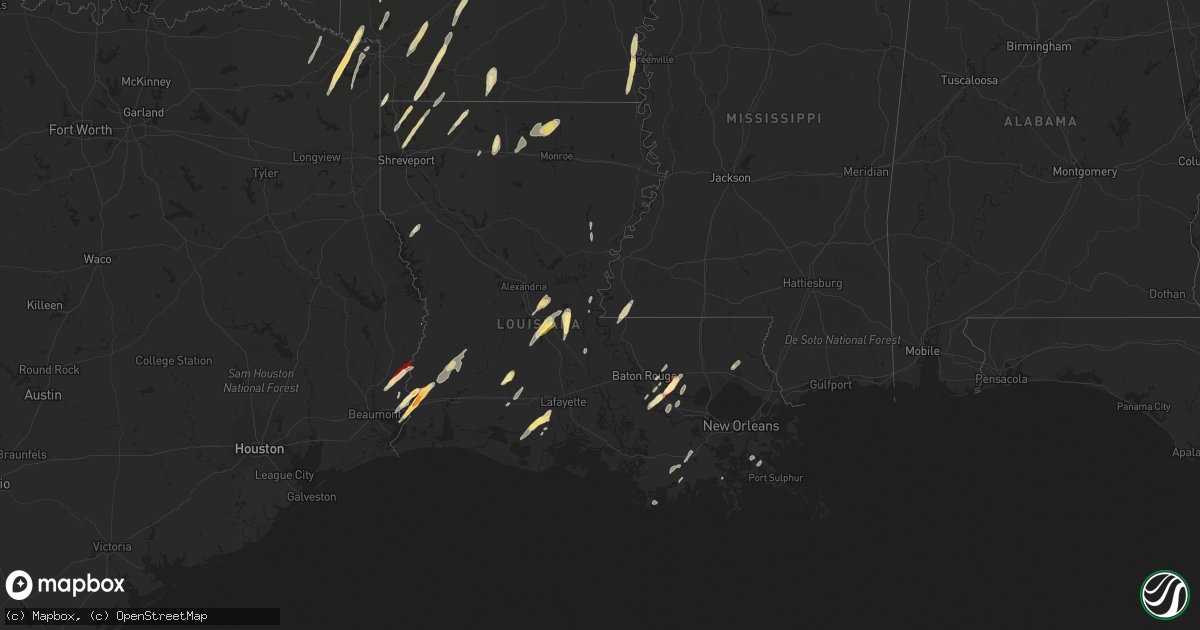
Hail Map in Louisiana on February 25, 2013
Get this storm
February 25 map
$229
one time, instant access
Download today. No call, no setup
Keep the $229
Bought the map and want the full workflow? Apply the entire $229 to a subscription within 7 days. None of it is wasted.
Every map, not just this one
This buys you this map. Subscription and you get every map we run, in the markets you choose from a few cities to whole states to nationwide. Plus real-time alerts the moment a storm fires.
Contact data
Name, contact info, occupancy, even credit band for addresses in the footprint. You go from where it hit to who to call.
Become the source they trust
Unlimited branding weather history reports on demand. You already have the documented answer ready for the property owner, and you are the one who showed up with it.
Property data and RoofTrace estimates
Pull up any address you have got, its value and the exact code rules for that jurisdiction, straight from One Click Code. Then RoofTrace estimates the squares, pitch, and roof value, priced the way you price.
Storm reports in Louisiana
Louisiana
| Date | Description |
|---|---|
| 02/25/20134:41 PM CST | A weak tornado touched down on an intermittent path from main port rd...just of industrial rd...extending northeast to the intersction of grand caillou rd and industria |
| 02/25/20134:41 PM CST | Vehicles damaged and power lines down near grand caillou road and industrial boulevard. Possible tornado. Event time estimated by radar. |
| 02/25/20132:40 PM CST | A local report indicates 1.75 inch wind near 9 S WALKER |
| 02/25/20132:36 PM CST | A local report indicates 1.00 inch wind near GONZALES |
| 02/25/20132:33 PM CST | Golf ball hail fell around the galvez community |
| 02/25/20132:30 PM CST | A local report indicates 1.00 inch wind near 3 N GONZALES |
| 02/25/20131:57 PM CST | A local report indicates 1.00 inch wind near SPRINGHILL |
| 02/25/20131:22 PM CST | A local report indicates 1.00 inch wind near PLAIN DEALING |
| 02/25/20131:00 PM CST | Public reports golf ball size hail near vinton |
| 02/25/201312:45 PM CST | Public reports quarter size hail near vinton |
| 02/25/201312:40 PM CST | Calcasieu parish sheriff reports golf ball size hail four miles west of vinton |
All States Impacted by Hail Map on February 25, 2013
Cities Impacted by Hail Map on February 25, 2013
- Mena, AR
- Vinton, LA
- Ashdown, AR
- Marietta, TX
- Simms, TX
- Naples, TX
- New Boston, TX
- Hooks, TX
- Gilliam, LA
- Plain Dealing, LA
- Hope, AR
- Morrilton, AR
- Atkins, AR
- Hattieville, AR
- Geismar, LA
- Gonzales, LA
- Abbeville, LA
- Kaplan, LA
- Maurice, LA
- Melville, LA
- Murfreesboro, AR
- Covington, LA
- Moreauville, LA
- Evergreen, LA
- Plaucheville, LA
- Morrow, LA
- Cottonport, LA
- Raceland, LA
- Houma, LA
- El Dorado, AR
- Junction City, AR
- Smackover, AR
- Ragley, LA
- Dequincy, LA
- Longville, LA
- Booneville, AR
- Havana, AR
- Blue Mountain, AR
- Magazine, AR
- Paris, AR
- Prescott, AR
- Arkadelphia, AR
- Gurdon, AR
- Madison, FL
- Lee, FL
- Wellborn, FL
- Live Oak, FL
- Lake Village, AR
- Waldo, AR
- Willisville, AR
- Bradley, AR
- Taylor, AR
- Lewisville, AR
- Stamps, AR
- Buckner, AR
- Bunkie, LA
- Ville Platte, LA
- Saint Landry, LA
- Donaldsonville, LA
- Gueydan, LA
- Rayne, LA
- Jacksonville, FL
- Hughes Springs, TX
- Rodessa, LA
- Doddridge, AR
- Ida, LA
- Marion, LA
- Sterlington, LA
- Farmerville, LA
- Bossier City, LA
- Benton, LA
- Dermott, AR
- Eudora, AR
- Portland, AR
- Arkansas City, AR
- Rohwer, AR
- Marksville, LA
- Lecompte, LA
- Alexandria, LA
- Pineville, LA
- Cheneyville, LA
- Hessmer, LA
- New Blaine, AR
- Scranton, AR
- Sanderson, FL
- Glen Saint Mary, FL
- Maud, TX
- Saint Amant, LA
- Mansura, LA
- Charleston, AR
- Fort Smith, AR
- Hodgen, OK
- Heavener, OK
- Mansfield, AR
- Waldron, AR
- Huntington, AR
- Hartford, AR
- Greenwood, AR
- Prairieville, LA
- French Settlement, LA
- Denham Springs, LA
- Emerson, AR
- Shongaloo, LA
- Sarepta, LA
- Springhill, LA
- Ardmore, OK
- Mill Creek, OK
- Darrow, LA
- Livingston, LA
- Donaldson, AR
- Mannsville, OK
- Sulphur, OK
- Woodville, MS
- Buna, TX
- Burkeville, TX
- Baton Rouge, LA
- Casa, AR
- Jennings, LA
- Saint Francisville, LA
- Braithwaite, LA
- Port Sulphur, LA
- Ruston, LA
- Dubach, LA
- Simsboro, LA
- Downsville, LA
- Converse, LA
- Cotton Valley, LA
- Shreveport, LA
- Lake City, FL
- Scotland, AR
- Clinton, AR
- Fox, AR
- Belcher, LA
- White Springs, FL
- Coalgate, OK
- Mineral Springs, AR
- Sicily Island, LA
- Orange, TX
- Cleveland, AR
- Pelican, LA
- Arcadia, LA
- Basile, LA
- Elton, LA
- Wewoka, OK
- Homer, LA
- Mayo, FL
- Day, FL
- Perry, FL
- Macclenny, FL
- De Kalb, TX
- Avery, TX
- Theriot, LA
- Norman, AR
- Walker, LA
- Starks, LA
- Clayton, OK
- Malvern, AR
- Deweyville, TX
- Call, TX
- Dennard, AR
- Maurepas, LA
- Emmet, AR
- Deridder, LA
- Dry Creek, LA
- Iota, LA
- Crowley, LA
- Egan, LA
- Evangeline, LA
- Convent, LA
- Sorrento, LA
- Paulina, LA
- Ozark, AR
- Bush, LA
- Haynesville, LA
- Minden, LA
- Broaddus, TX
- Nashville, AR
- Galliano, LA
- Cut Off, LA
- Texarkana, TX
- Douglassville, TX
- Atlanta, TX
- Saint Gabriel, LA
- Cecil, AR
- Merryville, LA
- Choudrant, LA
- Hartshorne, OK
- Broken Bow, OK
- Hardeeville, SC
- Rosston, AR
- Rattan, OK
- Maud, OK
- Washington, LA
- Eufaula, OK
- Sulphur, LA
- Bridge City, TX
- Centrahoma, OK
- Grambling, LA
- Eunice, LA
- Newhope, AR
- Bryceville, FL


