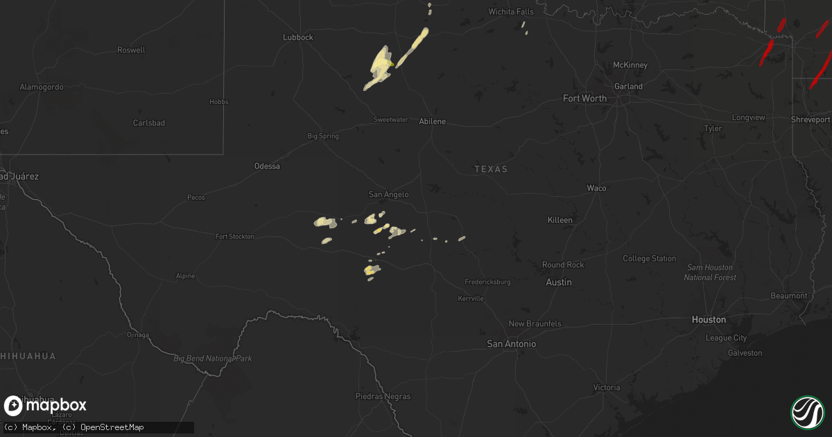
Hail Map in Texas on February 24, 2013
Get this storm
February 24 map
$229
one time, instant access
Download today. No call, no setup
Keep the $229
Bought the map and want the full workflow? Apply the entire $229 to a subscription within 7 days. None of it is wasted.
Every map, not just this one
This buys you this map. Subscription and you get every map we run, in the markets you choose from a few cities to whole states to nationwide. Plus real-time alerts the moment a storm fires.
Contact data
Name, contact info, occupancy, even credit band for addresses in the footprint. You go from where it hit to who to call.
Become the source they trust
Unlimited branding weather history reports on demand. You already have the documented answer ready for the property owner, and you are the one who showed up with it.
Property data and RoofTrace estimates
Pull up any address you have got, its value and the exact code rules for that jurisdiction, straight from One Click Code. Then RoofTrace estimates the squares, pitch, and roof value, priced the way you price.
Storm reports in Texas
Texas
| Date | Description |
|---|---|
| 02/23/201310:05 PM CST | A local report indicates 1.00 inch wind near JAYTON |
| 02/23/201310:02 PM CST | At the intersection of hywy 380 and 70... Received quarter and half-dollar sized hail. |
| 02/23/201310:02 PM CST | At the intersection of hywy 380 and 70... Received quarter and half-dollar sized hail. |
All States Impacted by Hail Map on February 24, 2013
Cities Impacted by Hail Map on February 24, 2013
- Kiln, MS
- Pass Christian, MS
- Valdosta, GA
- Pascagoula, MS
- Gulfport, MS
- Christoval, TX
- Sonora, TX
- Eldorado, TX
- Violet, LA
- Belle Chasse, LA
- New Orleans, LA
- Quitman, GA
- Morven, GA
- Dixie, GA
- Boston, GA
- Des Allemands, LA
- Belle Rose, LA
- Plattenville, LA
- Paulina, LA
- Convent, LA
- Gramercy, LA
- Napoleonville, LA
- Pierre Part, LA
- Saint James, LA
- Garyville, LA
- Lutcher, LA
- Maurepas, LA
- Springfield, LA
- Perry, FL
- Lamont, FL
- Saint Bernard, LA
- Ozona, TX
- Aspermont, TX
- Old Glory, TX
- Lafitte, LA
- Galliano, LA
- Marrero, LA
- Harvey, LA
- Gretna, LA
- Ama, LA
- Meraux, LA
- Braithwaite, LA
- Westwego, LA
- Ponchatoula, LA
- Saucier, MS
- Thibodaux, LA
- Mason, TX
- Seymour, TX
- Paducah, TX
- Sulphur, OK
- French Settlement, LA
- Livingston, LA
- Morgan City, LA
- Theriot, LA
- Lockport, LA
- Jayton, TX
- Frederick, OK
- Mertzon, TX
- Monticello, FL
- Tallahassee, FL
- Gibson, LA
- Houma, LA
- Schriever, LA
- Sorrento, LA
- Saint Amant, LA
- Raceland, LA
- Gray, LA
- Chalmette, LA
- Walters, OK
- Crawfordville, FL
- Big Lake, TX
- Menard, TX
- Vernon, TX
- Prairieville, LA
- Gonzales, LA
- Greenville, FL
- Berwick, LA
- San Angelo, TX
- Vacherie, LA
- Henrietta, TX
- Ville Platte, LA
- Barnhart, TX
- Davidson, OK
- Snyder, TX
- La Place, LA
- Geismar, LA
- Reserve, LA
- Hammond, LA
- Donaldsonville, LA
- Ada, OK
- Stratford, OK
- Thomasville, GA
- Crowell, TX
- Loveland, OK
- Roff, OK
- Metairie, LA
- Gheens, LA
- Mathews, LA
- Leland, MS
- Granite, OK
- Mangum, OK
- Randlett, OK
- Gulf Breeze, FL
- Washington, LA
- Naples, TX
- New Boston, TX
- Simms, TX
- Marietta, TX
- Ashdown, AR
- Taylor, AR
- Lewisville, AR
- Waldo, AR
- Rosston, AR
- Buckner, AR
- Stamps, AR
- Willisville, AR
- Bradley, AR
- Plain Dealing, LA
- Emmet, AR
- Hope, AR
- Prescott, AR
- Boutte, LA
- Paradis, LA


