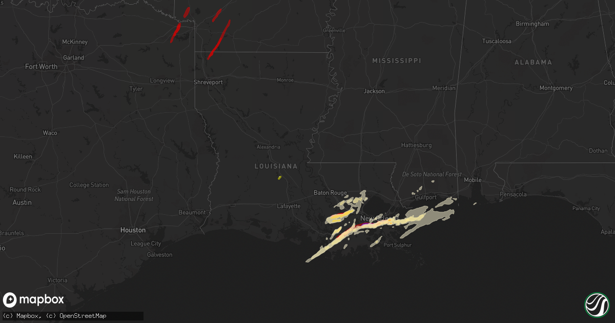
Hail Map in Louisiana on February 24, 2013
Get this storm
February 24 map
$229
one time, instant access
Download today. No call, no setup
Keep the $229
Bought the map and want the full workflow? Apply the entire $229 to a subscription within 7 days. None of it is wasted.
Every map, not just this one
This buys you this map. Subscription and you get every map we run, in the markets you choose from a few cities to whole states to nationwide. Plus real-time alerts the moment a storm fires.
Contact data
Name, contact info, occupancy, even credit band for addresses in the footprint. You go from where it hit to who to call.
Become the source they trust
Unlimited branding weather history reports on demand. You already have the documented answer ready for the property owner, and you are the one who showed up with it.
Property data and RoofTrace estimates
Pull up any address you have got, its value and the exact code rules for that jurisdiction, straight from One Click Code. Then RoofTrace estimates the squares, pitch, and roof value, priced the way you price.
Storm reports in Louisiana
Louisiana
| Date | Description |
|---|---|
| 02/24/201312:10 AM CST | Public reported golf ball sized hail in st. James parish via facebook page. |
| 02/24/201312:10 AM CST | Hail lasted approximately 15 minutes. |
| 02/23/20139:18 PM CST | A local report indicates 1.50 inch wind near VIOLET |
| 02/23/20139:15 PM CST | Nws co-op observer reports ping pong ball sized hail a terrytonw. |
| 02/23/20139:15 PM CST | Quarter sized hail reported in the lower garden district. |
| 02/23/20139:15 PM CST | Fire station 86 near lapalco and westwood reported golfball size hail. |
| 02/23/20139:09 PM CST | Media report of dimes to quarter sized hail near ville platte |
| 02/23/20139:09 PM CST | Media report of dimes to quarter sized hail near ville platte |
| 02/23/20138:40 PM CST | Public reports quarter sized hail in des allemands. |
| 02/23/20138:32 PM CST | Power lines down. Shed destroyed. Possible tornado. |
| 02/23/20137:37 PM CST | Hail lasted 15 to 20 minutes. Report from facebook. |
| 02/23/20137:35 PM CST | Golfball size hail reported in gibson/bayou black area. |
All States Impacted by Hail Map on February 24, 2013
Cities Impacted by Hail Map on February 24, 2013
- Kiln, MS
- Pass Christian, MS
- Valdosta, GA
- Pascagoula, MS
- Gulfport, MS
- Christoval, TX
- Sonora, TX
- Eldorado, TX
- Violet, LA
- Belle Chasse, LA
- New Orleans, LA
- Quitman, GA
- Morven, GA
- Dixie, GA
- Boston, GA
- Des Allemands, LA
- Belle Rose, LA
- Plattenville, LA
- Paulina, LA
- Convent, LA
- Gramercy, LA
- Napoleonville, LA
- Pierre Part, LA
- Saint James, LA
- Garyville, LA
- Lutcher, LA
- Maurepas, LA
- Springfield, LA
- Perry, FL
- Lamont, FL
- Saint Bernard, LA
- Ozona, TX
- Aspermont, TX
- Old Glory, TX
- Lafitte, LA
- Galliano, LA
- Marrero, LA
- Harvey, LA
- Gretna, LA
- Ama, LA
- Meraux, LA
- Braithwaite, LA
- Westwego, LA
- Ponchatoula, LA
- Saucier, MS
- Thibodaux, LA
- Mason, TX
- Seymour, TX
- Paducah, TX
- Sulphur, OK
- French Settlement, LA
- Livingston, LA
- Morgan City, LA
- Theriot, LA
- Lockport, LA
- Jayton, TX
- Frederick, OK
- Mertzon, TX
- Monticello, FL
- Tallahassee, FL
- Gibson, LA
- Houma, LA
- Schriever, LA
- Sorrento, LA
- Saint Amant, LA
- Raceland, LA
- Gray, LA
- Chalmette, LA
- Walters, OK
- Crawfordville, FL
- Big Lake, TX
- Menard, TX
- Vernon, TX
- Prairieville, LA
- Gonzales, LA
- Greenville, FL
- Berwick, LA
- San Angelo, TX
- Vacherie, LA
- Henrietta, TX
- Ville Platte, LA
- Barnhart, TX
- Davidson, OK
- Snyder, TX
- La Place, LA
- Geismar, LA
- Reserve, LA
- Hammond, LA
- Donaldsonville, LA
- Ada, OK
- Stratford, OK
- Thomasville, GA
- Crowell, TX
- Loveland, OK
- Roff, OK
- Metairie, LA
- Gheens, LA
- Mathews, LA
- Leland, MS
- Granite, OK
- Mangum, OK
- Randlett, OK
- Gulf Breeze, FL
- Washington, LA
- Naples, TX
- New Boston, TX
- Simms, TX
- Marietta, TX
- Ashdown, AR
- Taylor, AR
- Lewisville, AR
- Waldo, AR
- Rosston, AR
- Buckner, AR
- Stamps, AR
- Willisville, AR
- Bradley, AR
- Plain Dealing, LA
- Emmet, AR
- Hope, AR
- Prescott, AR
- Boutte, LA
- Paradis, LA


