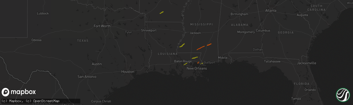
Hail Map in Louisiana on February 21, 2013
The weather event in Louisiana on February 21, 2013 includes Hail map. 3 states and 30 cities were impacted and suffered possible damage. The total estimated number of properties impacted is 11,677.
Want more than just the map?
Turn this storm into a full workflow.
- Owner + property data so you know who to knock
- OnDemand branded weather history reports to win the "did we even have hail?" argument
- RoofTrace estimate so reps stop guessing numbers at the door
Bought this map? Upgrade within 7 days and we'll credit the $230. (10-15 min setup call)
Hail
11,677
Estimated number of impacted properties by a 1.00" hail or larger0
Estimated number of impacted properties by a 1.75" hail or larger0
Estimated number of impacted properties by a 2.50" hail or largerStorm reports in Louisiana
Louisiana
| Date | Description |
|---|---|
| 02/21/20135:12 PM CST | Nws storm survey found an ef1 tornado with maximum winds of 90mph...maximum width of 75yds and path length of 2.5 miles. The tornado touched down near highway 65 where |
| 02/21/20135:10 PM CST | Roof was blown off a house along hwy 65 near clayton. |
| 02/21/20135:10 PM CST | Roof was blown off a house along hwy 65 near clayton. Likely tornado based off photo. |
| 02/21/20134:21 PM CST | Tree down on highway 84 3 miles west of the highway 84 and 459 intersection on the west side of jena. |
| 02/21/20133:07 PM CST | Large tree snapped and a few broken branches across kisatchie-mora rd and was rated an ef-1 |
| 02/21/20133:01 PM CST | Ft polk doppler radar using dual polarization confirmed tornadic debris signature near kurthwood. |
| 02/21/20133:00 PM CST | Nws storm survey did find damage from a ef1 tornado in the alco area...east of of kurthwood. More details will be issued this afternoon in a pns. |
All States Impacted by Hail Map on February 21, 2013
Cities Impacted by Hail Map on February 21, 2013
- Roxie, MS
- Natchez, MS
- Columbia, MS
- Ellisville, MS
- Moselle, MS
- Laurel, MS
- Ovett, MS
- Tylertown, MS
- Sumrall, MS
- Hattiesburg, MS
- Kokomo, MS
- Foxworth, MS
- Camden, AR
- Hampton, AR
- Bay Saint Louis, MS
- Slidell, LA
- Lacombe, LA
- Saint Amant, LA
- French Settlement, LA
- Denham Springs, LA
- Donaldsonville, LA
- Prairieville, LA
- Geismar, LA
- Gonzales, LA
- Franklinton, LA
- Loranger, LA
- Independence, LA
- Covington, LA
- Bogalusa, LA
- Folsom, LA


