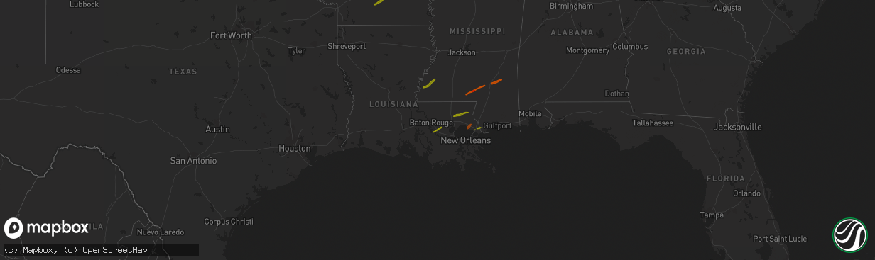
Hail Map on February 21, 2013
The weather event on February 21, 2013 includes Hail map. 3 states and 30 cities were impacted and suffered possible damage. The total estimated number of properties impacted is 18,027.
Want more than just the map?
Turn this storm into a full workflow.
- Owner + property data so you know who to knock
- OnDemand branded weather history reports to win the "did we even have hail?" argument
- RoofTrace estimate so reps stop guessing numbers at the door
Bought this map? Upgrade within 7 days and we'll credit the $230. (10-15 min setup call)
Hail
18,027
Estimated number of impacted properties by a 1.00" hail or larger1,114
Estimated number of impacted properties by a 1.75" hail or larger0
Estimated number of impacted properties by a 2.50" hail or largerStates Impacted by Hail Map on February 21, 2013
Storm reports
Arkansas
| Date | Description |
|---|---|
| 02/21/20139:18 AM CST | Quarter sized hail at interstate 430 and colonel glenn road. |
| 02/21/20138:16 AM CST | A local report indicates 1.00 inch wind near 1 S PINEBERGEN |
| 02/21/20137:31 AM CST | Half dollar sized hail east of camden. |
Louisiana
| Date | Description |
|---|---|
| 02/21/20135:12 PM CST | Nws storm survey found an ef1 tornado with maximum winds of 90mph...maximum width of 75yds and path length of 2.5 miles. The tornado touched down near highway 65 where |
| 02/21/20135:10 PM CST | Roof was blown off a house along hwy 65 near clayton. Likely tornado based off photo. |
| 02/21/20135:10 PM CST | Roof was blown off a house along hwy 65 near clayton. |
| 02/21/20134:21 PM CST | Tree down on highway 84 3 miles west of the highway 84 and 459 intersection on the west side of jena. |
| 02/21/20133:07 PM CST | Large tree snapped and a few broken branches across kisatchie-mora rd and was rated an ef-1 |
| 02/21/20133:01 PM CST | Ft polk doppler radar using dual polarization confirmed tornadic debris signature near kurthwood. |
| 02/21/20133:00 PM CST | Nws storm survey did find damage from a ef1 tornado in the alco area...east of of kurthwood. More details will be issued this afternoon in a pns. |
Texas
| Date | Description |
|---|---|
| 02/21/20131:40 PM CST | *** 1 fatal *** numerous trees downed along centerview road near the sabine/san augustine county line. Other trees were downed along highway 96 a few miles north of pin |
| 02/21/20131:35 PM CST | Several homes damaged near strickland crossing and 2 injuries reported |
| 02/21/20131:17 PM CST | Jasper sheriff relayed a public report of trees blown down about 8 miles west of jasper tx. Time estimated by radar |
| 02/21/20131:10 PM CST | *** 1 fatal *** ef-1 tornado damage found from the intersection of charlie forse rd and fm-1 to fm-2024 and strickland crossing west rd. Path length was 4.5 miles...max |
| 02/21/201312:54 PM CST | Tyler county sheriff reports widespread wind gusts in excess of 60 mph and hail of unknown size. |
| 02/21/201312:19 PM CST | Trees down on windham ranch road. |
| 02/21/201312:16 PM CST | Barn damaged in goodrich. |
| 02/21/201311:45 AM CST | Trees and powerlines down and damage to a residence and nearby barn on fm 1911 near intersection with fm 1247 |
| 02/21/201311:07 AM CST | Lumber yard building sustained structural damage with tin panels bent and a roof panel picked up and thrown onto the ground. Also tree limbs down around town. |
Mississippi
| Date | Description |
|---|---|
| 02/21/20133:50 PM CST | Pine tree snapped along hwy 84. |
| 02/21/20133:25 PM CST | 2 trees down...one on liberty rd and cranfield rd. |
| 02/20/201311:00 PM CST | This brief tornado moved along mcdonald chapel rd...a chicken house had part of the roof torn off...a mobile home had some skirting blown out and several trees were sna |
| 02/20/201310:59 PM CST | Along mcdonald chapel rd a chicken house had roughly 100 ft of the roof torn off...a home under construction had some windows blown out and insulation removed...a few t |
| 02/20/201310:34 PM CST | Update...tornado reported near greens creek community. Preliminary reports of mobile home with heavy damage along davis lane...tree across house on dyess road...numerou |
| 02/20/201310:31 PM CST | The tornado started along smith lane and moved ne...the tornado peaked as it moved along green creek rd and carson-bunker hill rd. Two well built frame homes were heavi |
| 02/20/20137:50 PM CST | Tree was blown down on hwy 51 |
Cities Impacted by Hail Map on February 21, 2013
- Roxie, MS
- Natchez, MS
- Columbia, MS
- Ellisville, MS
- Moselle, MS
- Laurel, MS
- Ovett, MS
- Tylertown, MS
- Sumrall, MS
- Hattiesburg, MS
- Kokomo, MS
- Foxworth, MS
- Camden, AR
- Hampton, AR
- Bay Saint Louis, MS
- Slidell, LA
- Lacombe, LA
- Saint Amant, LA
- French Settlement, LA
- Denham Springs, LA
- Donaldsonville, LA
- Prairieville, LA
- Geismar, LA
- Gonzales, LA
- Franklinton, LA
- Loranger, LA
- Independence, LA
- Covington, LA
- Bogalusa, LA
- Folsom, LA