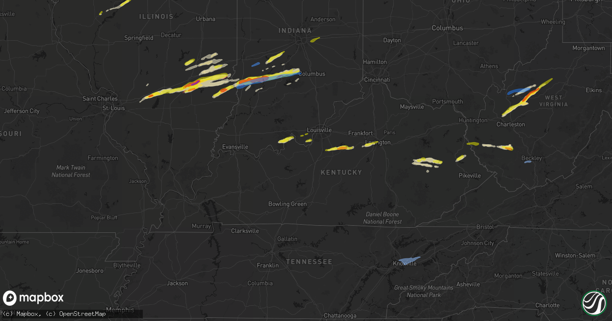
Hail Map in Kentucky on February 19, 2026
Get this storm
February 19 map
$229
one time, instant access
Download today. No call, no setup
Keep the $229
Bought the map and want the full workflow? Apply the entire $229 to a subscription within 7 days. None of it is wasted.
Every map, not just this one
This buys you this map. Subscription and you get every map we run, in the markets you choose from a few cities to whole states to nationwide. Plus real-time alerts the moment a storm fires.
Contact data
Name, contact info, occupancy, even credit band for addresses in the footprint. You go from where it hit to who to call.
Become the source they trust
Unlimited branding weather history reports on demand. You already have the documented answer ready for the property owner, and you are the one who showed up with it.
Property data and RoofTrace estimates
Pull up any address you have got, its value and the exact code rules for that jurisdiction, straight from One Click Code. Then RoofTrace estimates the squares, pitch, and roof value, priced the way you price.
Storm reports in Kentucky
Kentucky
| Date | Description |
|---|---|
| 02/19/20263:48 PM CST | A tree was reported to have been blown down onto powerlines between mm 10 and mm 12 of ky 1812. |
| 02/19/20263:32 PM CST | Social media user shared approximately quarter-sized hailstones. Time estimated from radar. |
| 02/19/20263:28 PM CST | Social media user reports tree down on road. |
| 02/19/20263:24 PM CST | Quarter size hail was estimated to have fallen. |
| 02/19/20263:03 PM CST | A local report indicates 1.00 inch wind near 3 WSW Lexington |
| 02/19/20262:56 PM CST | Report from mping: quarter |
| 02/19/20262:54 PM CST | A local report indicates 1.00 inch wind near Lexington |
| 02/19/20262:54 PM CST | A local report indicates 1.00 inch wind near 3 WSW Lexington |
| 02/19/20262:52 PM CST | Report from mping: quarter |
| 02/19/20262:03 PM CST | A local report indicates 1.00 inch wind near Bloomfield |
| 02/19/20261:50 PM CST | A local report indicates 1.00 inch wind near 1 N Coxs Creek |
| 02/19/20261:40 PM CST | Hail a little larger than quarter size. |
| 02/19/202612:44 AM CST | Trees and powerlines were downed onto cressmont road between todds road and ky 399 closing the roadway for a period of time. The event time is radar estimated. |
All States Impacted by Hail Map on February 19, 2026
Cities Impacted by Hail Map on February 19, 2026
- Logansport, IN
- Royal Center, IN
- Francesville, IN
- Rensselaer, IN
- Medaryville, IN
- Winamac, IN
- Bourbon, IN
- Etna Green, IN
- Goshen, IN
- New Paris, IN
- Millersburg, IN
- Villa Ridge, MO
- Union, MO
- Pacific, MO
- Roann, IN
- North Manchester, IN
- Urbana, IN
- Servia, IN
- Lagro, IN
- Huntington, IN
- Andrews, IN
- Markle, IN
- Roanoke, IN
- Cannelton, IN
- Battletown, KY
- Leavenworth, IN
- Uniondale, IN
- Ossian, IN
- Derby, IN
- Leopold, IN
- Tell City, IN
- Payneville, KY
- Corydon, IN
- Lanesville, IN
- Coxs Creek, KY
- Taylorsville, KY
- Bloomfield, KY
- Fairfield, KY
- Laconia, IN
- Elizabeth, IN
- Chaplin, KY
- Lawrenceburg, KY
- Mount Eden, KY
- Spencer, WV
- Gandeeville, WV
- Walton, WV
- Shepherdsville, KY
- Looneyville, WV
- Willisburg, KY
- Versailles, KY
- Lexington, KY
- Nicholasville, KY
- Edgewood, IL
- Mason, IL
- Watson, IL
- Stewardson, IL
- Strasburg, IL
- Windsor, IL
- Campton, KY
- Rogers, KY
- Slade, KY
- Beattyville, KY
- Farina, IL
- Winchester, KY
- Louisa, KY
- Fort Gay, WV
- Genoa, WV
- Dunlow, WV
- Dieterich, IL
- Effingham, IL
- Gays, IL
- Mattoon, IL
- Zoe, KY
- Pine Ridge, KY
- Neoga, IL
- Wheeler, IL
- Auxier, KY
- Prestonsburg, KY
- East Point, KY
- Hazel Green, KY
- Vancleve, KY
- Jackson, KY
- Debord, KY
- Van Lear, KY
- Harts, WV
- Toledo, IL
- Jewett, IL
- Salyersville, KY
- Hagerhill, KY
- Meally, KY
- Boons Camp, KY
- Tomahawk, KY
- Newton, IL
- Montrose, IL
- Hidalgo, IL
- Bays, KY
- Rousseau, KY
- Olney, IL
- Claremont, IL
- Greenup, IL
- Dundas, IL
- Salvisa, KY
- Willow Hill, IL
- Oblong, IL
- Sumner, IL
- Robinson, IL
- Casey, IL
- Chapmanville, WV
- Yale, IL
- Ashmore, IL
- Charleston, IL
- Westfield, IL
- Flat Rock, IL
- Martinsville, IL
- Annapolis, IL
- Kansas, IL
- West York, IL
- Palestine, IL
- Hutsonville, IL
- Merom, IN
- Sullivan, IN
- Bob White, WV
- Jeffrey, WV
- Clothier, WV
- Hewett, WV
- Bim, WV
- Yolyn, WV
- Lake, WV
- Van, WV
- Marshall, IL
- Spencer, IN
- Poland, IN
- Quincy, IN
- Cloverdale, IN
- Gosport, IN
- Madison, WV
- Gordon, WV
- Twilight, WV
- Carlisle, IN
- West Union, IL
- Martinsville, IN
- Dugger, IN
- Jasonville, IN
- Linton, IN
- Greenville, IL
- Pocahontas, IL
- Paragon, IN
- Keyesport, IL
- Monrovia, IN
- Stilesville, IN
- Poca, WV
- Charleston, WV
- Elkview, WV
- Kenna, WV
- Vandalia, IL
- Smithboro, IL
- Mulberry Grove, IL
- Worthington, IN
- Switz City, IN
- Cory, IN
- Advent, WV
- Clay City, IN
- Centerpoint, IN
- Shobonier, IL
- Coal City, IN
- Bloomfield, IN
- Freedom, IN
- Solsberry, IN
- Bloomington, IN
- Brownstown, IL
- Saint Peter, IL
- Saint Elmo, IL
- Louisville, IL
- Arnoldsburg, WV
- Astoria, IL
- Rushville, IL
- Mount Zion, WV
- Grantsville, WV
- Nashville, IN
- Unionville, IN
- Coxs Mills, WV
- Big Springs, WV
- Morgantown, IN
- Nineveh, IN
- Havana, IL
- Topeka, IL
- Lewistown, IL
- Manito, IL
- Sigel, IL
- Green Valley, IL
- Pekin, IL
- Lerna, IL
- Trilla, IL
- South Pekin, IL
- Tremont, IL
- Peoria, IL
- Mapleton, IL
- Xenia, OH
- Creston, WV
- Palestine, WV
- Reedy, WV
- Sylvester, WV
- Seth, WV
- Greenfield, IN
- Columbus, IN
- Hope, IN
- Lyons, IN
- Sandborn, IN
- Canton, IL
- Bowling Green, IN
- Donnellson, IL
- Glasford, IL
- Newberry, IN
- Danville, WV
- Browning, IL
- Ipava, IL
- Highland, IL
- New Palestine, IN
- Heltonville, IN
- Norman, IN
- Glenville, WV
- New Milton, WV
- Troy, WV
- Millstone, WV
- Elizabeth, WV
- Big Bend, WV
- Le Roy, WV
- Gay, WV
- Munday, WV
- Strawberry Plains, TN
- Powell, TN
- New Market, TN
- Knoxville, TN
- Daniels, WV
- Beaver, WV
- Slab Fork, WV
- Coal City, WV
- Crab Orchard, WV
- Lester, WV
- Glen White, WV
- Sophia, WV
- Midway, WV
- Shady Spring, WV
- Ripley, WV
- Sandyville, WV


