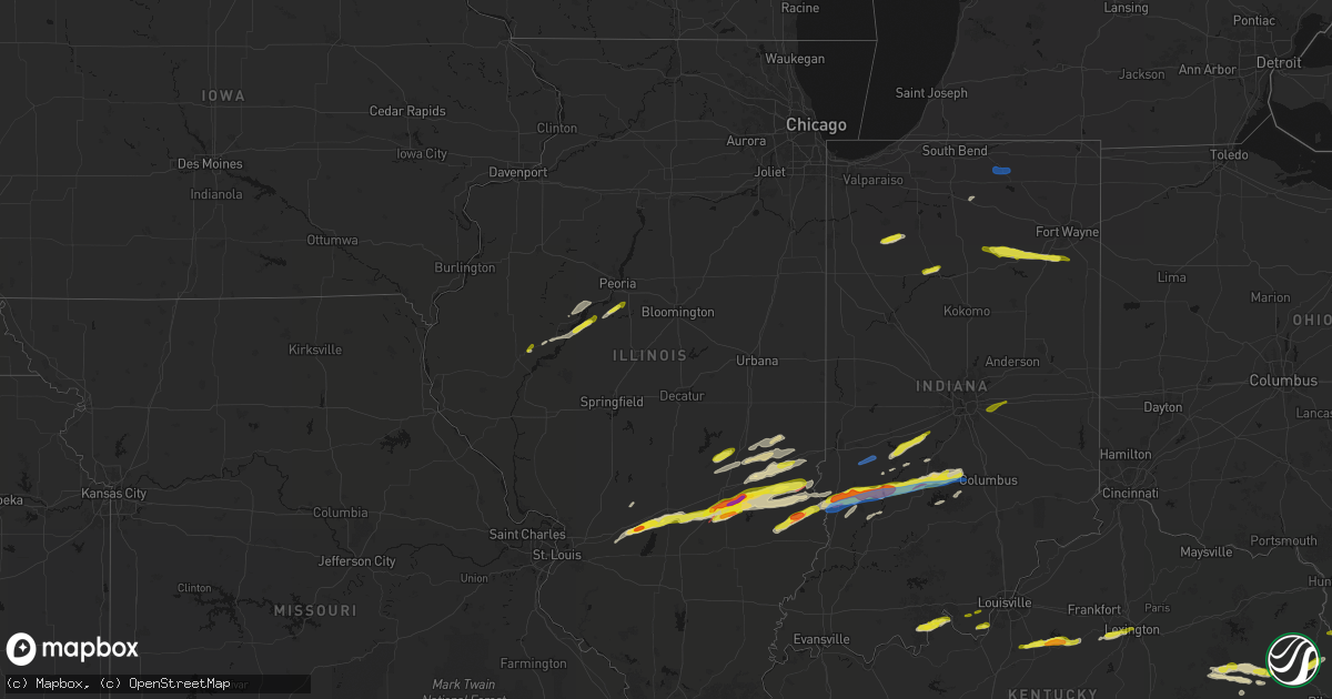
Hail Map in Illinois on February 19, 2026
Get this storm
February 19 map
$229
one time, instant access
Download today. No call, no setup
Keep the $229
Bought the map and want the full workflow? Apply the entire $229 to a subscription within 7 days. None of it is wasted.
Every map, not just this one
This buys you this map. Subscription and you get every map we run, in the markets you choose from a few cities to whole states to nationwide. Plus real-time alerts the moment a storm fires.
Contact data
Name, contact info, occupancy, even credit band for addresses in the footprint. You go from where it hit to who to call.
Become the source they trust
Unlimited branding weather history reports on demand. You already have the documented answer ready for the property owner, and you are the one who showed up with it.
Property data and RoofTrace estimates
Pull up any address you have got, its value and the exact code rules for that jurisdiction, straight from One Click Code. Then RoofTrace estimates the squares, pitch, and roof value, priced the way you price.
Storm reports in Illinois
Illinois
| Date | Description |
|---|---|
| 02/19/20265:39 PM CST | A local report indicates 1.00 inch wind near Shobonier |
| 02/19/20265:15 PM CST | A local report indicates 1.75 inch wind near 1 NE Dudleyville |
| 02/19/20264:25 PM CST | Social media report. Copious amounts of hail. |
| 02/19/20264:25 PM CST | Tornado report relayed by lawrence county emergency manager. |
| 02/19/20264:25 PM CST | House destroyed with occupants trapped. |
| 02/19/20264:24 PM CST | Mobile home rolled over with occupants trapped. Three houses with roof off. |
| 02/19/20264:21 PM CST | Social media report. Time estimated from radar. |
| 02/19/20264:16 PM CST | A local report indicates 1.00 inch wind near Hardinville |
| 02/19/20264:16 PM CST | Delayed report. Quarter size hail reported via social media. Time estimated from radar. |
| 02/19/20264:12 PM CST | A local report indicates a tornado near 2.5 N Chauncey |
| 02/19/20264:12 PM CST | Delayed report. Time estimated by radar. Report relayed by broadcast media. |
| 02/19/20264:01 PM CST | Pea to quarter size hail for about 4 minutes and covering the ground. |
| 02/19/20263:44 PM CST | Half dollar to ping pong size hail with some golf ball size hailstones. |
| 02/19/20263:39 PM CST | Report from mping: half dollar |
| 02/19/20263:38 PM CST | A local report indicates 2.00 inch wind near Dieterich |
| 02/19/20263:38 PM CST | Report from mping: quarter |
| 02/19/20263:37 PM CST | Delayed report. Time estimated by radar. Report relayed by broadcast media. |
| 02/19/20263:16 PM CST | *** 1 inj *** corrects previous tstm wnd dmg report from 1.5 sw watson. Seven vehicle accident due to thunderstorm winds. 1 injury. |
| 02/19/20263:07 PM CST | A local report indicates a tornado near Mason |
| 02/19/20263:07 PM CST | Corrects previous tornado report from mason. Corrected location. |
| 02/19/20262:59 PM CST | Ef0... Peak wind speed 75 mph... Path length 3.0 miles. The tornado touched down just south of the clay and effingham county line... Near the edgewood rd. Curve... And |
| 02/18/20267:59 PM CST | A local report indicates 1.00 inch wind near 2 W Tremont |
| 02/18/20267:45 PM CST | A local report indicates 1.00 inch wind near Bellevue |
| 02/18/20267:25 PM CST | Half dollar size hail at sand ridge state forest. |
| 02/18/20266:28 PM CST | A local report indicates 1.00 inch wind near Ray |
| 02/18/20266:21 PM CST | A local report indicates a tornado near 4 N Bible Grove |
| 02/18/20266:15 PM CST | Ef0... 75 mph... Path length 4.1 miles. Much of the damage was concentrated at a farmstead along the clay/effingham county line east of 1800th st. Metal from the top of |
All States Impacted by Hail Map on February 19, 2026
Cities Impacted by Hail Map on February 19, 2026
- Logansport, IN
- Royal Center, IN
- Francesville, IN
- Rensselaer, IN
- Medaryville, IN
- Winamac, IN
- Bourbon, IN
- Etna Green, IN
- Goshen, IN
- New Paris, IN
- Millersburg, IN
- Villa Ridge, MO
- Union, MO
- Pacific, MO
- Roann, IN
- North Manchester, IN
- Urbana, IN
- Servia, IN
- Lagro, IN
- Huntington, IN
- Andrews, IN
- Markle, IN
- Roanoke, IN
- Cannelton, IN
- Battletown, KY
- Leavenworth, IN
- Uniondale, IN
- Ossian, IN
- Derby, IN
- Leopold, IN
- Tell City, IN
- Payneville, KY
- Corydon, IN
- Lanesville, IN
- Coxs Creek, KY
- Taylorsville, KY
- Bloomfield, KY
- Fairfield, KY
- Laconia, IN
- Elizabeth, IN
- Chaplin, KY
- Lawrenceburg, KY
- Mount Eden, KY
- Spencer, WV
- Gandeeville, WV
- Walton, WV
- Shepherdsville, KY
- Looneyville, WV
- Willisburg, KY
- Versailles, KY
- Lexington, KY
- Nicholasville, KY
- Edgewood, IL
- Mason, IL
- Watson, IL
- Stewardson, IL
- Strasburg, IL
- Windsor, IL
- Campton, KY
- Rogers, KY
- Slade, KY
- Beattyville, KY
- Farina, IL
- Winchester, KY
- Louisa, KY
- Fort Gay, WV
- Genoa, WV
- Dunlow, WV
- Dieterich, IL
- Effingham, IL
- Gays, IL
- Mattoon, IL
- Zoe, KY
- Pine Ridge, KY
- Neoga, IL
- Wheeler, IL
- Auxier, KY
- Prestonsburg, KY
- East Point, KY
- Hazel Green, KY
- Vancleve, KY
- Jackson, KY
- Debord, KY
- Van Lear, KY
- Harts, WV
- Toledo, IL
- Jewett, IL
- Salyersville, KY
- Hagerhill, KY
- Meally, KY
- Boons Camp, KY
- Tomahawk, KY
- Newton, IL
- Montrose, IL
- Hidalgo, IL
- Bays, KY
- Rousseau, KY
- Olney, IL
- Claremont, IL
- Greenup, IL
- Dundas, IL
- Salvisa, KY
- Willow Hill, IL
- Oblong, IL
- Sumner, IL
- Robinson, IL
- Casey, IL
- Chapmanville, WV
- Yale, IL
- Ashmore, IL
- Charleston, IL
- Westfield, IL
- Flat Rock, IL
- Martinsville, IL
- Annapolis, IL
- Kansas, IL
- West York, IL
- Palestine, IL
- Hutsonville, IL
- Merom, IN
- Sullivan, IN
- Bob White, WV
- Jeffrey, WV
- Clothier, WV
- Hewett, WV
- Bim, WV
- Yolyn, WV
- Lake, WV
- Van, WV
- Marshall, IL
- Spencer, IN
- Poland, IN
- Quincy, IN
- Cloverdale, IN
- Gosport, IN
- Madison, WV
- Gordon, WV
- Twilight, WV
- Carlisle, IN
- West Union, IL
- Martinsville, IN
- Dugger, IN
- Jasonville, IN
- Linton, IN
- Greenville, IL
- Pocahontas, IL
- Paragon, IN
- Keyesport, IL
- Monrovia, IN
- Stilesville, IN
- Poca, WV
- Charleston, WV
- Elkview, WV
- Kenna, WV
- Vandalia, IL
- Smithboro, IL
- Mulberry Grove, IL
- Worthington, IN
- Switz City, IN
- Cory, IN
- Advent, WV
- Clay City, IN
- Centerpoint, IN
- Shobonier, IL
- Coal City, IN
- Bloomfield, IN
- Freedom, IN
- Solsberry, IN
- Bloomington, IN
- Brownstown, IL
- Saint Peter, IL
- Saint Elmo, IL
- Louisville, IL
- Arnoldsburg, WV
- Astoria, IL
- Rushville, IL
- Mount Zion, WV
- Grantsville, WV
- Nashville, IN
- Unionville, IN
- Coxs Mills, WV
- Big Springs, WV
- Morgantown, IN
- Nineveh, IN
- Havana, IL
- Topeka, IL
- Lewistown, IL
- Manito, IL
- Sigel, IL
- Green Valley, IL
- Pekin, IL
- Lerna, IL
- Trilla, IL
- South Pekin, IL
- Tremont, IL
- Peoria, IL
- Mapleton, IL
- Xenia, OH
- Creston, WV
- Palestine, WV
- Reedy, WV
- Sylvester, WV
- Seth, WV
- Greenfield, IN
- Columbus, IN
- Hope, IN
- Lyons, IN
- Sandborn, IN
- Canton, IL
- Bowling Green, IN
- Donnellson, IL
- Glasford, IL
- Newberry, IN
- Danville, WV
- Browning, IL
- Ipava, IL
- Highland, IL
- New Palestine, IN
- Heltonville, IN
- Norman, IN
- Glenville, WV
- New Milton, WV
- Troy, WV
- Millstone, WV
- Elizabeth, WV
- Big Bend, WV
- Le Roy, WV
- Gay, WV
- Munday, WV
- Strawberry Plains, TN
- Powell, TN
- New Market, TN
- Knoxville, TN
- Daniels, WV
- Beaver, WV
- Slab Fork, WV
- Coal City, WV
- Crab Orchard, WV
- Lester, WV
- Glen White, WV
- Sophia, WV
- Midway, WV
- Shady Spring, WV
- Ripley, WV
- Sandyville, WV


