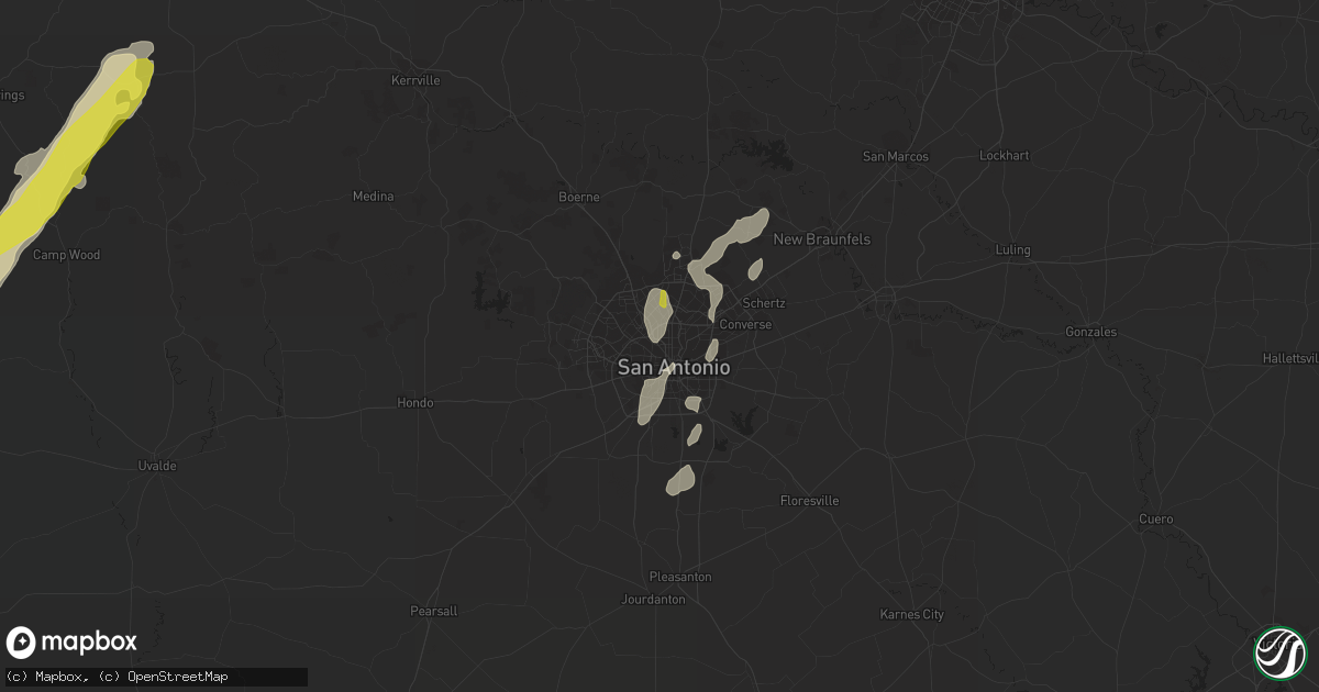
Hail Map in San Antonio, TX on February 19, 2017
Get this storm
February 19 map
$229
one time, instant access
Download today. No call, no setup
Keep the $229
Bought the map and want the full workflow? Apply the entire $229 to a subscription within 7 days. None of it is wasted.
Every map, not just this one
This buys you this map. Subscription and you get every map we run, in the markets you choose from a few cities to whole states to nationwide. Plus real-time alerts the moment a storm fires.
Contact data
Name, contact info, occupancy, even credit band for addresses in the footprint. You go from where it hit to who to call.
Become the source they trust
Unlimited branding weather history reports on demand. You already have the documented answer ready for the property owner, and you are the one who showed up with it.
Property data and RoofTrace estimates
Pull up any address you have got, its value and the exact code rules for that jurisdiction, straight from One Click Code. Then RoofTrace estimates the squares, pitch, and roof value, priced the way you price.
Storm reports in San Antonio, TX
San Antonio, TX
| Date | Description |
|---|---|
| 02/18/201710:55 PM CST | Possible tornado confirmed. Caller reported trees down... Homes damaged... Power lines down. |
| 02/18/201710:50 PM CST | Possible tornado damage reported. Apartment complex with roof blown off... 2-3 house with serious damage and several others with moderate to minor damage. |
| 02/18/201710:50 PM CST | Caller reported large trees in the road and traffic lights down. Possible tornado |
| 02/18/201710:50 PM CST | Report via social media... Large power tower mangled. |
| 02/18/201710:50 PM CST | Social media report possible tornado damage... Roof caved in. |
| 02/18/201710:45 PM CST | Possible tornado damage broadway and nacogdoches... Apartment roof blown off... Power lines to the ground. |
| 02/18/201710:45 PM CST | Report via social media near woodridge elementary... Roofs blown off... Trees down. |
| 02/18/201710:43 PM CST | Ef-1 damage was found along a path from 3nw of windcrest to 5wnw of universal city. |
| 02/18/201710:42 PM CST | Ef-0 damage was found along a path from 5sw of universal city to 3sw of universal city. |
| 02/18/201710:36 PM CST | Ef-1 damage was found along a path from 5n of san antonio to 3nne of terrell hills. |
| 02/18/201710:10 PM CST | Spotter reported quarter sized hail and heavy rain.. 2 inches. |
All Cities Impacted by Hail Map on February 19, 2017
- Uvalde, TX
- Batesville, TX
- La Pryor, TX
- Wimberley, TX
- Franklin, TX
- Quemado, TX
- Brackettville, TX
- Barksdale, TX
- Henrietta, TX
- Eldorado, TX
- Doole, TX
- Sonora, TX
- Eden, TX
- Voss, TX
- Junction, TX
- Fort McKavett, TX
- Menard, TX
- Millersview, TX
- Brady, TX
- San Ygnacio, TX
- Paint Rock, TX
- Leakey, TX
- Rocksprings, TX
- Encinal, TX
- Zapata, TX
- Cisco, TX
- Cross Plains, TX
- Brownwood, TX
- Rising Star, TX
- Asherton, TX
- Laredo, TX
- Canyon Lake, TX
- Spring Branch, TX
- San Antonio, TX
- Frederick, OK
- Snyder, OK
- Woodson, TX
- Albany, TX
- Throckmorton, TX
- Sabinal, TX
- Talpa, TX
- Ballinger, TX
- Roosevelt, TX
- Baird, TX
- Clyde, TX
- Moran, TX
- Floresville, TX
- Pleasanton, TX
- Eastland, TX
- Bigfoot, TX
- Charlotte, TX
- Poteet, TX
- Camp Wood, TX
- Fairmont, OK
- Mirando City, TX
- Bruni, TX
- Oilton, TX
- Elgin, OK
- D Hanis, TX
- Encino, TX
- Ranger, TX
- Caddo, TX
- Breckenridge, TX
- Crystal City, TX
- Hollister, OK
- Realitos, TX
- Hebbronville, TX
- Von Ormy, TX
- Rio Grande City, TX
- Coleman, TX
- Cotulla, TX
- Jbsa Lackland, TX
- Santa Elena, TX
- Bellevue, TX
- Dripping Springs, TX
- New Braunfels, TX
- Bulverde, TX
- Bangs, TX
- Santa Anna, TX
- Maysville, OK
- Schertz, TX
- Olney, TX
- Marshall, OK
- Bison, OK
- Hennessey, OK
- Mountain Park, OK
- Rowena, TX
- Jacksboro, TX
- Windthorst, TX
- Marlow, OK
- Bryson, TX
- Jourdanton, TX
- Bowie, TX
- Nardin, OK
- Braman, OK
- Melvin, TX
- Roosevelt, OK


