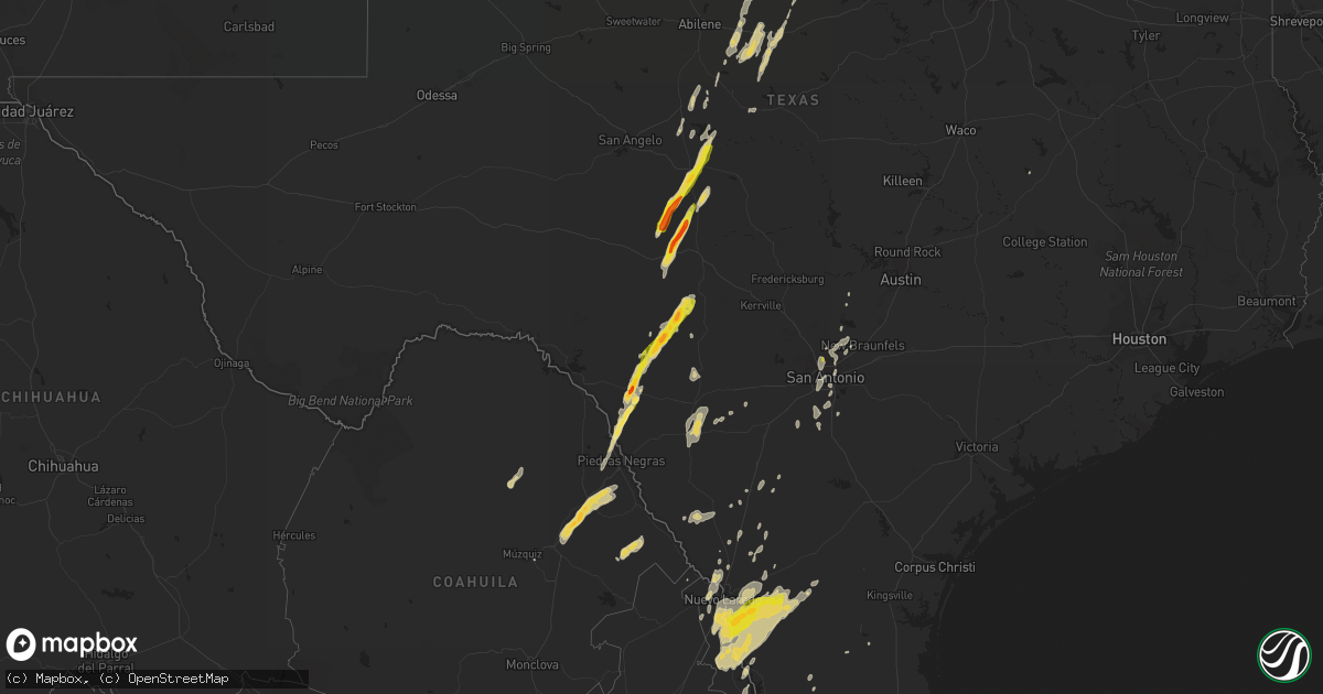
Hail Map on February 19, 2017
Get this storm
February 19 map
$229
one time, instant access
Download today. No call, no setup
Keep the $229
Bought the map and want the full workflow? Apply the entire $229 to a subscription within 7 days. None of it is wasted.
Every map, not just this one
This buys you this map. Subscription and you get every map we run, in the markets you choose from a few cities to whole states to nationwide. Plus real-time alerts the moment a storm fires.
Contact data
Name, contact info, occupancy, even credit band for addresses in the footprint. You go from where it hit to who to call.
Become the source they trust
Unlimited branding weather history reports on demand. You already have the documented answer ready for the property owner, and you are the one who showed up with it.
Property data and RoofTrace estimates
Pull up any address you have got, its value and the exact code rules for that jurisdiction, straight from One Click Code. Then RoofTrace estimates the squares, pitch, and roof value, priced the way you price.
Storm reports
Texas
| Date | Description |
|---|---|
| 02/19/20175:45 PM CST | Public reported hail falling approx quarter sized |
| 02/19/20175:45 PM CST | Power lines downs approx 2 miles south of fm 1665 and us 277 |
| 02/19/20175:41 PM CST | Received video via social media of hail up to the size of golfballs falling along us hwy 90 in brackettville |
| 02/19/20174:25 AM CST | Trees down blocking fm 782 as well as fm 2011 in northern rusk county. |
| 02/19/20174:15 AM CST | Trees down blocking county road 186 and fm 2276 just southeast of kilgore in northern rusk county. |
| 02/19/20174:15 AM CST | Power lines down in northwest longview. |
| 02/19/20173:50 AM CST | Power lines down near new london. |
| 02/19/20173:30 AM CST | Multiple trees down...powerlines down |
| 02/19/20173:30 AM CST | Multiple trees and power lines reported down in flint area |
| 02/19/20173:30 AM CST | Trees and power lines reported down in northern part of county in several locations |
| 02/19/20173:30 AM CST | Power lines down in whitehouse. |
| 02/19/20173:00 AM CST | Power lines down... Trees down on highway 7 west between crockett and the county line. |
| 02/19/20172:50 AM CST | Delayed report - columbia scientific balloon facility recorded wind gust of 68 mph. |
| 02/19/20172:30 AM CST | Trees and powerlines down across anderson county. Time estimated from radar. |
| 02/19/20172:22 AM CST | Trees down between kosse and bremond on hwy 14 |
| 02/19/20172:11 AM CST | An 18 wheeler hit a downed tree near normangee. Injuries unknown |
| 02/19/20172:01 AM CST | Trees down on fm 489 |
| 02/19/20171:55 AM CST | Off cr351. Several 40 plus feet pines toppled. Front wall of double wide torn from structure and now in the back yard. |
| 02/19/20171:46 AM CST | Trees were knocked down along highway 7 |
| 02/19/20171:45 AM CST | Approximately 30 trees were knocked down along cr 386. Other downed trees were reported across the county. |
| 02/19/20171:45 AM CST | Xrpr - lake limestone raws site |
| 02/19/20171:45 AM CST | Delayed report---metal roof panel torn off over asphalt decking of brick veneer home. |
| 02/19/20171:45 AM CST | A barn ended up in the middle of highway 7 near marquez |
| 02/19/20171:45 AM CST | The roofs of 6 chicken houses were blown off and other debris was scattered in the area |
| 02/19/20171:43 AM CST | Trees down on hwy 79 |
| 02/19/20171:42 AM CST | Delayed report---franklin vfd reported damage to outbuildings and damage to shingles. Numerous trees were snapped/uprooted as well as utility poles north of franklin. T |
| 02/19/20171:41 AM CST | Barn and shop flattened on cr431. |
| 02/19/20171:33 AM CST | Carport torn up and pickup damaged hwy 14 and lcr 277 |
| 02/19/20171:30 AM CST | Delayed report---picture of a trailer overturned at lsp trucking facility. Report relayed via wfo houston/galveston. Time estimated via radar. |
| 02/19/20171:20 AM CST | Heavy wind damage reported between blue ridge and bremond |
| 02/19/20171:15 AM CST | Roof off at least one house in calvert. Trees down across the county. |
| 02/19/20171:00 AM CST | Large trees down blocking cr 120 fm3058 road southeast of caldwell. |
| 02/19/20171:00 AM CST | Large trees down blocking 7500 cr 319 road... West of chriesman. |
| 02/19/201712:55 AM CST | Several large |
| 02/19/201712:45 AM CST | Awnings over the gas pumps damaged at the cefco |
| 02/19/201712:43 AM CST | Delayed report---milam county oem reported roof damage to a few structures in rockdale. Time estimated via radar. |
| 02/19/201712:41 AM CST | Tree blown across hwy 77 north of lexington. Wind gust measured at 78 mph. Time estimated from radar. |
| 02/19/201712:36 AM CST | Media and social medial reporting train derailment. Picture shows at least one car tipped over. |
| 02/19/201712:35 AM CST | Delayed report---thorndale co-op observer estimates 40 ft. Tall tree down on house in thorndale with damage to the eave of house. Time estimated via radar. |
| 02/19/201712:28 AM CST | *** 2 inj *** at least 10 homes were significantly damaged along a path from 2nw of thrall to 2n of thrall. In addition...at least a dozen farm outbuildings...mobile ho |
| 02/19/201712:28 AM CST | Ef-2 damage was found in the vicinity of thrall. The most significant damage was to a 3-bin grain storage facility where the bins were completely destroyed and swept fr |
| 02/19/201712:25 AM CST | Multiple power poles down with isolated tree and roof damage across the southern portion of elgin. |
| 02/19/201712:25 AM CST | A tornado caused damage from 5 wsw of thrall to 4 ene of thrall. The most significant damage was to a metal building system home...at least five other single family hom |
| 02/19/201712:24 AM CST | Media viewer reported house siding and roof damage. |
| 02/19/201712:15 AM CST | Report via the web reporting roof was blown off and debris scattered over 5 acres. |
| 02/19/201712:10 AM CST | Em reported damage to several trees with large limbs down. Also significant damage to a garage or car port. |
| 02/19/201712:00 AM CST | Media viewer reported porch awning ripped off. |
| 02/18/201711:50 PM CST | Media viewer reported shed destroyed... Power lines down... Roof busted. |
| 02/18/201711:47 PM CST | Metal roof damaged from a large shop |
| 02/18/201711:40 PM CST | Public report of damage to a barn roof and front porch awning as well as a 100 year old tree down. |
| 02/18/201711:14 PM CST | An rv shop had several rvs overturned. |
| 02/18/201711:06 PM CST | Mostly juniper and cedar tree damage. Diameter of limbs from 5 inches up to over 1 foot. |
| 02/18/201711:00 PM CST | Large highway sign down along interstate 35 at schertz parkway |
| 02/18/201711:00 PM CST | Multiple reports of damage in this area along a half mile stretch of cedar creek drive. Several power lines down with small trees on roofs. |
| 02/18/201711:00 PM CST | Ef-0 damage was found along a path from 3ne of garden ridge to 4ne of garden ridge. |
| 02/18/201710:55 PM CST | Possible tornado confirmed. Caller reported trees down... Homes damaged... Power lines down. |
| 02/18/201710:50 PM CST | Possible tornado damage reported. Apartment complex with roof blown off... 2-3 house with serious damage and several others with moderate to minor damage. |
| 02/18/201710:50 PM CST | Caller reported large trees in the road and traffic lights down. Possible tornado |
| 02/18/201710:50 PM CST | Report via social media... Large power tower mangled. |
| 02/18/201710:50 PM CST | Social media report possible tornado damage... Roof caved in. |
| 02/18/201710:45 PM CST | Report via social media near woodridge elementary... Roofs blown off... Trees down. |
| 02/18/201710:45 PM CST | Possible tornado damage broadway and nacogdoches... Apartment roof blown off... Power lines to the ground. |
| 02/18/201710:43 PM CST | Ef-1 damage was found along a path from 3nw of windcrest to 5wnw of universal city. |
| 02/18/201710:42 PM CST | Ef-0 damage was found along a path from 5sw of universal city to 3sw of universal city. |
| 02/18/201710:36 PM CST | Ef-1 damage was found along a path from 5n of san antonio to 3nne of terrell hills. |
| 02/18/201710:10 PM CST | Spotter reported quarter sized hail and heavy rain.. 2 inches. |
| 02/18/20179:35 PM CST | Newspaper received report of a few sheds blown over north of the city of devine. |
| 02/18/20178:10 PM CST | Video from kgns-tv showed damage to laredo public works department building. Roof was blown off and tower was blown over. |
| 02/18/20178:10 PM CST | 76 mph wind gust at klrd |
| 02/18/20178:00 PM CST | Several trees reported down on lagos and bustamante streets |
Oklahoma
| Date | Description |
|---|---|
| 02/18/20179:55 PM CST | Light pole down in roadway |
| 02/18/20179:45 PM CST | Trees down blocking roadway |
| 02/18/20178:25 PM CST | Measured at the army air station |
| 02/18/20178:22 PM CST | Roof damage and 2-inch tree limbs downed |
Cities Impacted by Hail Map on February 19, 2017
- Uvalde, TX
- Batesville, TX
- La Pryor, TX
- Wimberley, TX
- Franklin, TX
- Quemado, TX
- Brackettville, TX
- Barksdale, TX
- Henrietta, TX
- Eldorado, TX
- Doole, TX
- Sonora, TX
- Eden, TX
- Voss, TX
- Junction, TX
- Fort McKavett, TX
- Menard, TX
- Millersview, TX
- Brady, TX
- San Ygnacio, TX
- Paint Rock, TX
- Leakey, TX
- Rocksprings, TX
- Encinal, TX
- Zapata, TX
- Cisco, TX
- Cross Plains, TX
- Brownwood, TX
- Rising Star, TX
- Asherton, TX
- Laredo, TX
- Canyon Lake, TX
- Spring Branch, TX
- San Antonio, TX
- Frederick, OK
- Snyder, OK
- Woodson, TX
- Albany, TX
- Throckmorton, TX
- Sabinal, TX
- Talpa, TX
- Ballinger, TX
- Roosevelt, TX
- Baird, TX
- Clyde, TX
- Moran, TX
- Floresville, TX
- Pleasanton, TX
- Eastland, TX
- Bigfoot, TX
- Charlotte, TX
- Poteet, TX
- Camp Wood, TX
- Fairmont, OK
- Mirando City, TX
- Bruni, TX
- Oilton, TX
- Elgin, OK
- D Hanis, TX
- Encino, TX
- Ranger, TX
- Caddo, TX
- Breckenridge, TX
- Crystal City, TX
- Hollister, OK
- Realitos, TX
- Hebbronville, TX
- Von Ormy, TX
- Rio Grande City, TX
- Coleman, TX
- Cotulla, TX
- Jbsa Lackland, TX
- Santa Elena, TX
- Bellevue, TX
- Dripping Springs, TX
- New Braunfels, TX
- Bulverde, TX
- Bangs, TX
- Santa Anna, TX
- Maysville, OK
- Schertz, TX
- Olney, TX
- Marshall, OK
- Bison, OK
- Hennessey, OK
- Mountain Park, OK
- Rowena, TX
- Jacksboro, TX
- Windthorst, TX
- Marlow, OK
- Bryson, TX
- Jourdanton, TX
- Bowie, TX
- Nardin, OK
- Braman, OK
- Melvin, TX
- Roosevelt, OK