Hail Map in Kilgore, TX on February 18, 2013
The weather event in Kilgore, TX on February 18, 2013 includes Hail map. 4 states and 131 cities were impacted and suffered possible damage. The total estimated number of properties impacted is 2,816.
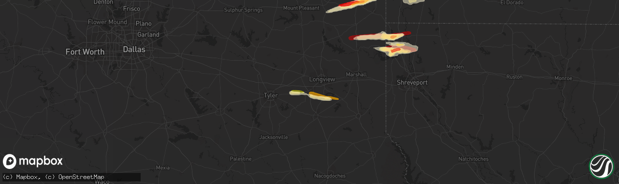
Hail
2,816
Estimated number of impacted properties by a 1.00" hail or larger2,559
Estimated number of impacted properties by a 1.75" hail or larger0
Estimated number of impacted properties by a 2.50" hail or largerStorm reports in Kilgore, TX
Kilgore, TX
| Date | Description |
|---|---|
| 02/18/20135:18 PM CST | A brief ef-0 tornado snapped the tops out of several pine trees along hwy 322 near barnes creek. The path length was 30 yds...the path width was 20 yds...and the estima |
| 02/18/20135:09 PM CST | An ef-0 tornado snapped several large branches and a hardwood tree along county roads 281 and 283. The path length was 0.75 mi...the path width was 30 yds...and maximum |
All Cities Impacted by Hail Map on February 18, 2013
- Malvern, AR
- Pearcy, AR
- Hot Springs National Park, AR
- Bismarck, AR
- Columbus, AR
- Okolona, AR
- Mineral Springs, AR
- Prescott, AR
- Blevins, AR
- Nashville, AR
- Gurdon, AR
- Hope, AR
- Ozan, AR
- Clarksville, AR
- Hagarville, AR
- Lamar, AR
- Huntsville, AR
- Berryville, AR
- Star City, AR
- Naples, TX
- Douglassville, TX
- Fouke, AR
- Queen City, TX
- Texarkana, AR
- Marietta, TX
- Atlanta, TX
- Spiro, OK
- Mount Ida, AR
- Bonnerdale, AR
- Glenwood, AR
- Caddo Gap, AR
- Norman, AR
- Sallisaw, OK
- Muldrow, OK
- Laneville, TX
- Jefferson, TX
- Oil City, LA
- Belcher, LA
- Vivian, LA
- Mooringsport, LA
- Hartman, AR
- Ozark, AR
- Ozone, AR
- Benton, LA
- Winslow, AR
- West Fork, AR
- Fayetteville, AR
- Vian, OK
- Garland City, AR
- Bunch, OK
- Kilgore, TX
- Bivins, TX
- Avinger, TX
- Newhope, AR
- Langley, AR
- Umpire, AR
- Cove, AR
- Grannis, AR
- Mena, AR
- Wickes, AR
- Gore, OK
- Cleveland, TX
- Ida, LA
- Hosston, LA
- Compton, AR
- Porum, OK
- Stigler, OK
- Lockesburg, AR
- Tyler, TX
- Overton, TX
- Fordyce, AR
- Sparkman, AR
- Emmet, AR
- Talihina, OK
- Gans, OK
- Henderson, TX
- Mulberry, AR
- Mountainburg, AR
- Gillham, AR
- Smithville, OK
- Watson, OK
- Mount Enterprise, TX
- Daingerfield, TX
- Tatum, TX
- Lewisville, AR
- Taylor, AR
- Stamps, AR
- Magnolia, AR
- Carthage, AR
- Livingston, LA
- Holden, LA
- Maud, TX
- Gilliam, LA
- Troup, TX
- Beckville, TX
- Ashdown, AR
- Fulton, AR
- Longview, TX
- Kirby, AR
- Pocola, OK
- Fort Smith, AR
- Bokoshe, OK
- Keota, OK
- Delight, AR
- Hammond, LA
- Springfield, LA
- Alma, AR
- Plain Dealing, LA
- Van Buren, AR
- Amity, AR
- Alexander, AR
- Benton, AR
- Red Oak, OK
- Wister, OK
- Roland, OK
- Arkadelphia, AR
- Lavaca, AR
- Abbeville, LA
- Kingston, AR
- Tucker, AR
- Rudy, AR
- Knoxville, AR
- London, AR
- Royal, AR
- Webbers Falls, OK
- Uniontown, AR
- Timpson, TX
- Garrison, TX
- Long Branch, TX
- Winona, TX
- McCaskill, AR


