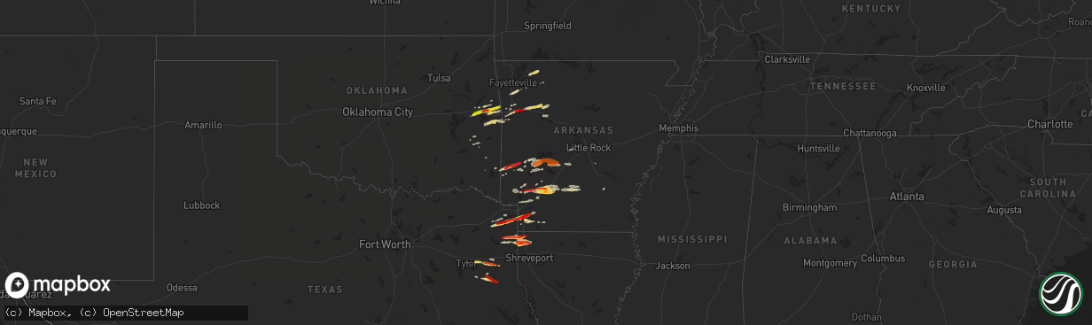
Hail Map on February 18, 2013
The weather event on February 18, 2013 includes Hail map. 4 states and 131 cities were impacted and suffered possible damage. The total estimated number of properties impacted is 36,564.
Want more than just the map?
Turn this storm into a full workflow.
- Owner + property data so you know who to knock
- OnDemand branded weather history reports to win the "did we even have hail?" argument
- RoofTrace estimate so reps stop guessing numbers at the door
Bought this map? Upgrade within 7 days and we'll credit the $230. (10-15 min setup call)
Hail
36,564
Estimated number of impacted properties by a 1.00" hail or larger14,263
Estimated number of impacted properties by a 1.75" hail or larger0
Estimated number of impacted properties by a 2.50" hail or largerStorm reports
Arkansas
| Date | Description |
|---|---|
| 02/18/20135:45 PM CST | Several trees are down in sparkman. |
| 02/18/20135:45 PM CST | Multiple trees and power lines are down in and around the des arc area. There was also some roofing and siding taken off of several buildings. |
| 02/18/20135:45 PM CST | A local report indicates 1.00 inch wind near SPARKMAN |
| 02/18/20135:40 PM CST | A roof was removed from a house due to severe winds in the lynn community. In addition...several trees were uprooted in the area. This report was from a volunteer fire |
| 02/18/20135:29 PM CST | Reported at the air force base. |
| 02/18/20135:27 PM CST | A local report indicates 1.00 inch wind near JACKSONVILLE |
| 02/18/20135:24 PM CST | Tree down on interstate 30...with one lane blocked. |
| 02/18/20135:23 PM CST | A local report indicates 1.00 inch wind near SHERWOOD |
| 02/18/20135:15 PM CST | Hail fell for 15 minutes in redland community |
| 02/18/20135:12 PM CST | A tree fell on a car but there were no injuries. |
| 02/18/20134:59 PM CST | A tree was blown over by the wind and fell on a moving vehicle. This tree shattered the windshield of the vehicle. |
| 02/18/20134:50 PM CST | Trees and power lines are down along hwy 84 at morgan road. Update...a house was destroyed and several cars were flipped. |
| 02/18/20134:43 PM CST | A local report indicates 1.00 inch wind near HOT SPRINGS |
| 02/18/20134:38 PM CST | *** 1 inj *** house slid off foundation and collapsed as a result of severe thunderstorm winds estimated at 80-90 mph. |
| 02/18/20134:38 PM CST | Strong wind gusts toppled several trees along hwy 84 west of biskmark. |
| 02/18/20134:36 PM CST | A local report indicates 1.00 inch wind near PARON |
| 02/18/20134:30 PM CST | Trees and powerlines down in town due to thunderstorms. |
| 02/18/20134:25 PM CST | A large tree was downed along highway 84 outside of amity. |
| 02/18/20134:25 PM CST | A local report indicates 1.25 inch wind near 2 N TOLLETTE |
| 02/18/20134:20 PM CST | Trees and powerlines down in town due to thunderstomers. |
| 02/18/20134:10 PM CST | Hail was reported on pigeon roost road. |
| 02/18/20134:03 PM CST | A fence was damaged due to strong winds knocking brances off of a tree. |
| 02/18/20133:36 PM CST | A tree is across highway 8 at the caddo hills school area. |
| 02/18/20133:36 PM CST | A local report indicates 1.00 inch wind near 2 E SCRANTON |
| 02/18/20133:30 PM CST | A brief ef-0 snapped several hardwood branches and a small hardwood tree along hwy 134. The path length was 40 yds...the path width was 20 yds...and maximum winds were |
| 02/18/20133:22 PM CST | A local report indicates 1.75 inch wind near 4 N FOUKE |
| 02/18/20133:22 PM CST | Near genoa |
| 02/18/20133:15 PM CST | A local report indicates 1.75 inch wind near 2 NW CLARKSVILLE |
| 02/18/20133:10 PM CST | Quarter sized hail reported in the community of owley. |
| 02/18/20132:53 PM CST | A local report indicates 1.00 inch wind near OZARK |
| 02/18/20132:43 PM CST | A local report indicates 1.00 inch wind near 5 W OZARK |
| 02/18/20132:15 PM CST | A local report indicates 1.00 inch wind near WICKES |
| 02/17/20137:11 PM CST | Reports of hail on hwy 425 south of star city. |
| 02/17/20136:43 PM CST | A local report indicates 1.00 inch wind near RISON |
| 02/17/20136:13 PM CST | Trees and power lines are down across des arc and the surrounding areas. A house had some roofing and siding damage. |
| 02/17/20136:00 PM CST | Several trees down across southeast portions of lawrence county along highway 67 and highway 25. This damage was roughly between alicia and minturn. In addition...a bar |
Missouri
| Date | Description |
|---|---|
| 02/18/20132:40 PM CST | Two small barns destroyed...one tree down...time of event estimated from radar |
Texas
| Date | Description |
|---|---|
| 02/18/20135:57 PM CST | An ef-0 tornado snapped numerous large limbs and a few trees along fm 1794. Several pictures and a video of the tornado were captured by the public. The path length was |
| 02/18/20135:48 PM CST | An ef1 tornado snapped trees and large branches along county road 3156. It moved southeastward and overturned a travel trailer and ripped the roof off of a metal barn a |
| 02/18/20135:33 PM CST | A local report indicates 1.00 inch wind near 13 SE LONGVIEW |
| 02/18/20135:27 PM CST | An ef0 tornado uprooted several trees and snapped large branches along fm 1798 and fm 839 near cat creek. The path length was 1.15 miles...the path width was 0.15 miles |
| 02/18/20135:27 PM CST | An ef-0 tornado uprooted and snapped the tops of several pine trees long county road 2126 and fm 782. The path length was 1.5 miles...the path width was 30 yds...and th |
| 02/18/20135:18 PM CST | A brief ef-0 tornado snapped the tops out of several pine trees along hwy 322 near barnes creek. The path length was 30 yds...the path width was 20 yds...and the estima |
| 02/18/20135:09 PM CST | An ef-0 tornado snapped several large branches and a hardwood tree along county roads 281 and 283. The path length was 0.75 mi...the path width was 30 yds...and maximum |
| 02/18/20133:10 PM CST | Half dollar sized hail fell in domino. |
| 02/18/20132:39 PM CST | A local report indicates 1.75 inch wind near DOUGLASSVILLE |
| 02/18/20132:30 PM CST | Homes damaged and trees down near shepherd texas |
| 02/18/20132:03 PM CST | Home and trees damaged.barn destroyed. Worst damage consistent with ef1 level winds. |
| 02/18/20132:00 PM CST | Homes damaged and trees down near shepherd texas |
| 02/17/20136:37 PM CST | A brief ef0 tornado snapped several large limbs along county road 4916 and us hwy 59. The path length was 0.15 miles...the path width was 10 yards...and maximum winds w |
| 02/17/20136:25 PM CST | Quarter size hail reported in the deberry community. |
| 02/17/20136:22 PM CST | Tree limbs three inces in diameter were down along cr 3185 |
| 02/17/20136:19 PM CST | An ef1 tornado peeled the roof of a metal building back...damaged the roof on a mobile home...and snapped a few trees along us hwy 84 in the community of caledonia. The |
| 02/17/20136:19 PM CST | An ef-0 tornado snapped two pine trees along fm 31 near the county road 316 intersection. The path length was 30 yds...the path width was 20 yds...and maximum winds wer |
| 02/17/20136:13 PM CST | A brief ef-0 tornado snapped a small hardwood tree along county road 307. The path length was 20 yds...the path width was 10 yds...and maximum winds were estimated at 7 |
| 02/17/20136:12 PM CST | A brief ef0 tornado snapped trees and wrapped an above-ground swimming pool around a tree along fm 95. The path length was 50 yards...the path width was 20 yards...and |
| 02/17/20136:09 PM CST | Telephone and powerlines down on 1794 |
| 02/17/20136:05 PM CST | An ef-0 tornado snapped numerous large limbs and a few pine trees along fm 1794 just south of the sabine river. The path length was 0.80 miles...the path width was 30 y |
| 02/17/20136:01 PM CST | A brief ef0 tornado snapped large hardwood branches along hwy 315. The path length was 20 yds...the path width was 10 yds...and maximum winds were estimated at 70 mph. |
Oklahoma
| Date | Description |
|---|---|
| 02/18/20132:30 PM CST | A local report indicates 1.25 inch wind near SPIRO |
| 02/18/20132:05 PM CST | Quarter size hail covering the ground. |
| 02/18/20132:00 PM CST | Nickel and quarter size hail covering the ground in akins. |
| 02/18/20131:45 PM CST | A local report indicates 1.75 inch wind near 4 WNW SALLISAW |
Louisiana
| Date | Description |
|---|---|
| 02/18/20135:55 PM CST | Golf ball and quarter size hail |
| 02/18/20135:45 PM CST | A local report indicates 1.00 inch wind near MOORINGSPORT |
| 02/18/20134:57 PM CST | A local report indicates 1.75 inch wind near VIVIAN |
| 02/18/20132:38 PM CST | An ef0 tornado snapped several large branches along hudson darby rd. And hwy 513. The path length was 2 miles...the path width was 10 yds...and maximum winds were estim |
| 02/17/20136:08 PM CST | An ef-0 tornado briefly touched down and snapped several hardwood branches along dixie shreveport road. The path length was 40 yards with a path width of 20 yards. Maxi |
| 02/17/20136:01 PM CST | An ef-0 tornado briefly touched down and snapped several hardwood branches along gamm road. The path length was 115 yards with a path width of 25 yards. Maximum winds w |
Cities Impacted by Hail Map on February 18, 2013
- Malvern, AR
- Pearcy, AR
- Hot Springs National Park, AR
- Bismarck, AR
- Columbus, AR
- Okolona, AR
- Mineral Springs, AR
- Prescott, AR
- Blevins, AR
- Nashville, AR
- Gurdon, AR
- Hope, AR
- Ozan, AR
- Clarksville, AR
- Hagarville, AR
- Lamar, AR
- Huntsville, AR
- Berryville, AR
- Star City, AR
- Naples, TX
- Douglassville, TX
- Fouke, AR
- Queen City, TX
- Texarkana, AR
- Marietta, TX
- Atlanta, TX
- Spiro, OK
- Mount Ida, AR
- Bonnerdale, AR
- Glenwood, AR
- Caddo Gap, AR
- Norman, AR
- Sallisaw, OK
- Muldrow, OK
- Laneville, TX
- Jefferson, TX
- Oil City, LA
- Belcher, LA
- Vivian, LA
- Mooringsport, LA
- Hartman, AR
- Ozark, AR
- Ozone, AR
- Benton, LA
- Winslow, AR
- West Fork, AR
- Fayetteville, AR
- Vian, OK
- Garland City, AR
- Bunch, OK
- Kilgore, TX
- Bivins, TX
- Avinger, TX
- Newhope, AR
- Langley, AR
- Umpire, AR
- Cove, AR
- Grannis, AR
- Mena, AR
- Wickes, AR
- Gore, OK
- Cleveland, TX
- Ida, LA
- Hosston, LA
- Compton, AR
- Porum, OK
- Stigler, OK
- Lockesburg, AR
- Tyler, TX
- Overton, TX
- Fordyce, AR
- Sparkman, AR
- Emmet, AR
- Talihina, OK
- Gans, OK
- Henderson, TX
- Mulberry, AR
- Mountainburg, AR
- Gillham, AR
- Smithville, OK
- Watson, OK
- Mount Enterprise, TX
- Daingerfield, TX
- Tatum, TX
- Lewisville, AR
- Taylor, AR
- Stamps, AR
- Magnolia, AR
- Carthage, AR
- Livingston, LA
- Holden, LA
- Maud, TX
- Gilliam, LA
- Troup, TX
- Beckville, TX
- Ashdown, AR
- Fulton, AR
- Longview, TX
- Kirby, AR
- Pocola, OK
- Fort Smith, AR
- Bokoshe, OK
- Keota, OK
- Delight, AR
- Hammond, LA
- Springfield, LA
- Alma, AR
- Plain Dealing, LA
- Van Buren, AR
- Amity, AR
- Alexander, AR
- Benton, AR
- Red Oak, OK
- Wister, OK
- Roland, OK
- Arkadelphia, AR
- Lavaca, AR
- Abbeville, LA
- Kingston, AR
- Tucker, AR
- Rudy, AR
- Knoxville, AR
- London, AR
- Royal, AR
- Webbers Falls, OK
- Uniontown, AR
- Timpson, TX
- Garrison, TX
- Long Branch, TX
- Winona, TX
- McCaskill, AR