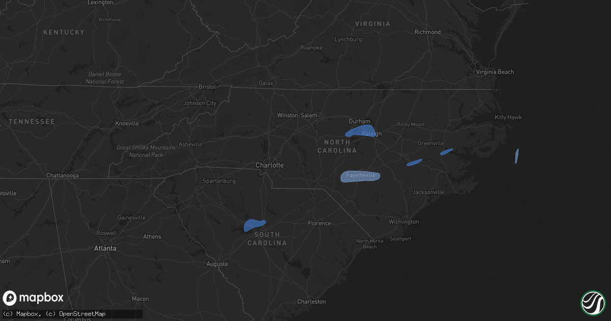
Hail Map in North Carolina on February 16, 2025
Get this storm
February 16 map
$229
one time, instant access
Download today. No call, no setup
Keep the $229
Bought the map and want the full workflow? Apply the entire $229 to a subscription within 7 days. None of it is wasted.
Every map, not just this one
This buys you this map. Subscription and you get every map we run, in the markets you choose from a few cities to whole states to nationwide. Plus real-time alerts the moment a storm fires.
Contact data
Name, contact info, occupancy, even credit band for addresses in the footprint. You go from where it hit to who to call.
Become the source they trust
Unlimited branding weather history reports on demand. You already have the documented answer ready for the property owner, and you are the one who showed up with it.
Property data and RoofTrace estimates
Pull up any address you have got, its value and the exact code rules for that jurisdiction, straight from One Click Code. Then RoofTrace estimates the squares, pitch, and roof value, priced the way you price.
Storm reports in North Carolina
North Carolina
| Date | Description |
|---|---|
| 02/16/202512:33 PM CST | Avon ocean - xavo weatherflow station reported 50kt gust. |
| 02/16/202512:26 PM CST | Avon sound wxflow recorded a 60 mph wind gust. |
| 02/16/202512:15 PM CST | Tree on a house on saunders lane reported at 115 pm est. Based on nearby wind observations the tree could have fallen between 1230 and 115 pm with gradient winds... Or |
| 02/16/202512:03 PM CST | Tempest station on dory rd recorded a 50 kt wind gust. |
| 02/16/202512:01 PM CST | Tree down and blocking road at sulphur springs rd and sharpe mill rd reported at 101 pm est. Based on nearby wind observations the tree could have fallen between 1230 a |
| 02/16/202510:38 AM CST | Tideland emc reports widespread power outages across western hyde county due to trees down on powerlines. |
| 02/16/202510:33 AM CST | Tideland emc reports power outages throughout eastern beaufort county from trees down on powerlines. |
| 02/16/202510:27 AM CST | Mping report of 3-inch tree limbs broken. |
| 02/16/202510:20 AM CST | Multiple structures damaged including a tree through a trailer. |
| 02/16/202510:15 AM CST | A 14x40 shed was moved 40-50 ft and had its windows blown out and roof caved in. |
| 02/16/202510:01 AM CST | Report of structural damage to roof of barn. Time estimated by radar. |
| 02/16/202510:00 AM CST | Local broadcast meteorologist relays report of power lines down near hwy13 and nash joyner rd. |
| 02/16/202510:00 AM CST | Pitt county 911 call center reports multiple power poles down. |
| 02/16/20259:40 AM CST | Tri-county electric membership corporation reporting outages north of beulaville due to downed trees and power lines affecting over 1000 customers. |
| 02/16/20259:40 AM CST | Spotter reports widespread wind damage across duplin county including power outages and roads blocked due to downed trees. |
| 02/16/20259:30 AM CST | Tri-county electric membership corporation reports power outages due to downed trees and power lines in la grange... Nc along and near hwy70. |
| 02/16/20259:20 AM CST | Report from mping: trees uprooted or snapped. |
| 02/16/20259:20 AM CST | A personal weather station in white lake... Nc reported a wind gust to 63 mph. |
| 02/16/20259:12 AM CST | Roof blown off building which impacted and caused structural damage to a mobile home. |
| 02/16/20259:12 AM CST | Corrects previous tstm wnd dmg report from 4 nne walnut creek. Damage to turkey farm... Singlewide mobile home and vehicles due to suspected straight-line winds. Signif |
| 02/16/20259:10 AM CST | Plethora of trees and powerlines reported down in this vicinity by wayne county em. |
| 02/16/20258:51 AM CST | Tree down at paul sledge rd near the nash county line. |
| 02/16/20258:49 AM CST | Report from mping: trees uprooted or snapped. |
| 02/16/20258:41 AM CST | Tree down at 1600 e river rd. |
| 02/16/20258:40 AM CST | Power outages due to downed trees on power lines. |
| 02/16/20258:34 AM CST | Power outages caused by fallen trees on lines. |
| 02/16/20258:25 AM CST | Tree down at tollie weldon rd and us highway 401. |
| 02/16/20258:24 AM CST | 59 mph gust measured at krdu. |
| 02/16/20258:23 AM CST | 61 mph gust measured at kfay. |
| 02/16/20258:15 AM CST | Trees down at the 160 and 1600 blocks of gordon moore rd. |
| 02/16/20258:14 AM CST | Structure damage reported near 116 south main street in red springs... Nc. Time estimated via radar. |
| 02/16/20258:00 AM CST | Tree down in roadway at the 700 block of chelsea dr. |
| 02/16/20257:53 AM CST | Numerous reports of trees down and power outages all throughout scotland county. So far there have been 14 calls regarding trees in roadways and 5 calls for power outag |
| 02/16/20257:42 AM CST | Very large tree down on doctor neal rd. |
| 02/16/20257:40 AM CST | Power lines down on cotten rd. |
| 02/16/20257:32 AM CST | A local report indicates 60 MPH wind near 3 N Bynum |
| 02/16/20257:31 AM CST | Power lines down at the 400 block of amos bridges rd. |
| 02/16/20257:25 AM CST | Tree down at bethlehem church rd and nc highway 24-27. |
| 02/16/20257:18 AM CST | Tree down at oak ridge rd and nc highway 705. |
| 02/16/20257:15 AM CST | Tree down at the 15400 block of nc highway 24-27. |
| 02/16/20257:11 AM CST | Tree down at nc highway 22/42 and brush creek rd. |
| 02/16/20257:09 AM CST | Tree and power lines down at the 6800 block of nc highway 49 s. Several other trees down throughout the county as well. |
| 02/16/20256:55 AM CST | Tree on a house on short st. Time estimated. |
| 02/16/20256:55 AM CST | Tree down on a house on travis ln. Occupant trapped but not injured. Time estimated. |
| 02/16/20256:54 AM CST | Tree down at barker st and mill st. |
| 02/16/20256:52 AM CST | 1000 power outages from trees down. |
| 02/16/20256:37 AM CST | Power outage attributed to fallen trees or limbs near intersection of wilgrove mint hill rd and truelight church rd. |
| 02/16/20256:32 AM CST | Power lines down at old highway 29 and turner rd. |
| 02/16/20256:25 AM CST | Power outage due to fallen trees or limbs in downtown mooresville. Time estimated. |
All States Impacted by Hail Map on February 16, 2025
Cities Impacted by Hail Map on February 16, 2025
- Utica, MS
- Crystal Springs, MS
- Terry, MS
- Raymond, MS
- Byram, MS
- Little Mountain, SC
- Chapin, SC
- Lexington, SC
- Gilbert, SC
- Irmo, SC
- Jenkinsville, SC
- Columbia, SC
- Winnsboro, SC
- Blythewood, SC
- Raeford, NC
- Fort Bragg, NC
- Shannon, NC
- Red Springs, NC
- Fayetteville, NC
- Hope Mills, NC
- Lumber Bridge, NC
- Parkton, NC
- Chapel Hill, NC
- Pittsboro, NC
- Apex, NC
- Cary, NC
- Durham, NC
- Morrisville, NC
- Raleigh, NC
- Garner, NC
- Salemburg, NC
- Stedman, NC
- Wade, NC
- Autryville, NC
- Roseboro, NC
- Lumberton, NC
- Fairmont, NC
- Orrum, NC
- Bladenboro, NC
- Elizabethtown, NC
- White Oak, NC
- Tar Heel, NC
- Clarkton, NC
- Wallace, NC
- Harrells, NC
- Garland, NC
- Ivanhoe, NC
- Willard, NC
- Teachey, NC
- Goldsboro, NC
- La Grange, NC
- Dudley, NC
- Snow Hill, NC
- Hookerton, NC
- Seven Springs, NC
- Kinston, NC
- Vanceboro, NC
- Chocowinity, NC
- Grimesland, NC
- Blounts Creek, NC
- Washington, NC
- Salvo, NC
- Waves, NC
- Buxton, NC
- Avon, NC
- Hatteras, NC
- Ocracoke, NC
- Frisco, NC


