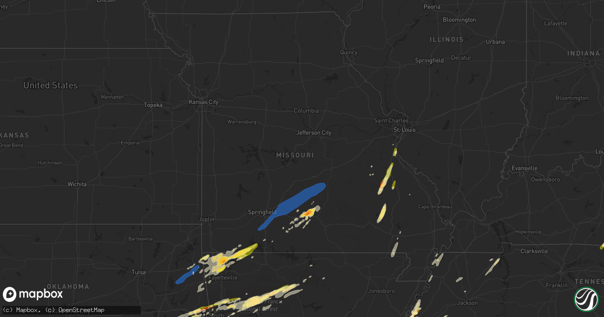
Hail Map in Missouri on February 15, 2023
Get this storm
February 15 map
$229
one time, instant access
Download today. No call, no setup
Keep the $229
Bought the map and want the full workflow? Apply the entire $229 to a subscription within 7 days. None of it is wasted.
Every map, not just this one
This buys you this map. Subscription and you get every map we run, in the markets you choose from a few cities to whole states to nationwide. Plus real-time alerts the moment a storm fires.
Contact data
Name, contact info, occupancy, even credit band for addresses in the footprint. You go from where it hit to who to call.
Become the source they trust
Unlimited branding weather history reports on demand. You already have the documented answer ready for the property owner, and you are the one who showed up with it.
Property data and RoofTrace estimates
Pull up any address you have got, its value and the exact code rules for that jurisdiction, straight from One Click Code. Then RoofTrace estimates the squares, pitch, and roof value, priced the way you price.
Storm reports in Missouri
Missouri
| Date | Description |
|---|---|
| 02/15/20233:10 AM CST | Report from mping: quarter |
| 02/15/20233:10 AM CST | A local report indicates 1.25 inch wind near FESTUS |
| 02/15/20233:08 AM CST | Hailed for approximately 2 minutes. Variety of hail sizes with largest stones to 1.25 inches. |
| 02/15/20232:49 AM CST | County dispatch received a report of a tree down on highway n. Time estimated from radar. |
| 02/15/20232:35 AM CST | County dispatch received a report of three trees down along long spring road in steelville. Time estimated from radar. |
| 02/15/20232:35 AM CST | Report from mping: quarter |
| 02/15/20232:32 AM CST | Via photo on facebook with hail also covering large portion of ground. |
| 02/15/20232:27 AM CST | County dispatch received a report of a tree down along highway m. Time estimated from radar. |
| 02/15/20232:24 AM CST | Report from mping: quarter |
| 02/15/20232:03 AM CST | Measured wind speed of 58 mph resulted in the breaking of 1 to 2 inch diameter tree branches 7 miles to the south of newburg. Time estimated from radar. |
| 02/15/20231:29 AM CST | A local report indicates 2.00 inch wind near MOUNTAIN GROVE |
| 02/15/20231:28 AM CST | Pictures showing hail of nickel to quarter size in mountain grove near old highway 60. Time estimated from radar. |
| 02/15/202312:59 AM CST | 7 miles east of niangua pea size hail and limbs down |
| 02/15/202312:27 AM CST | 59.6mph measured wind gust at 1227am cdt |
| 02/15/202312:12 AM CST | Reports of small limbs down and power out. Estimated 60 plus mph. |
| 02/15/202312:12 AM CST | Mills rd s of country thyme a downed cedar tree in highlandville. |
| 02/14/202311:49 PM CST | A local report indicates 1.00 inch wind near KIMBERLING CITY |
| 02/14/202311:45 PM CST | A local report indicates 1.00 inch wind near 5 ESE GOLDEN |
| 02/14/202311:41 PM CST | Near stone/barry line off yy. |
| 02/14/202311:37 PM CST | Report from mping: quarter |
| 02/14/202311:32 PM CST | Report from mping: quarter |
| 02/14/202311:28 PM CST | . |
All States Impacted by Hail Map on February 15, 2023
Cities Impacted by Hail Map on February 15, 2023
- Duncan, OK
- Davis, OK
- Stratford, OK
- Wynnewood, OK
- Hennepin, OK
- Sulphur, OK
- Ada, OK
- Sasakwa, OK
- Konawa, OK
- Ratliff City, OK
- Tussy, OK
- Elmore City, OK
- Allen, OK
- Holdenville, OK
- Atwood, OK
- Fitzhugh, OK
- Stonewall, OK
- Centrahoma, OK
- Tupelo, OK
- Mcalester, OK
- Coalgate, OK
- Calvin, OK
- Stuart, OK
- Roff, OK
- Indianola, OK
- Van Buren, AR
- Gans, OK
- Sallisaw, OK
- Uniontown, AR
- Muldrow, OK
- Wilburton, OK
- Red Oak, OK
- Hartshorne, OK
- Haileyville, OK
- Fort Smith, AR
- Pocola, OK
- Cameron, OK
- Hackett, AR
- Shady Point, OK
- Poteau, OK
- Springer, OK
- Kansas, OK
- Rose, OK
- Hulbert, OK
- Tahlequah, OK
- Oaks, OK
- Colcord, OK
- De Kalb, TX
- Sulphur Springs, AR
- Jay, OK
- Gravette, AR
- Maysville, AR
- Lowell, AR
- Springdale, AR
- Rogers, AR
- Kimberling City, MO
- Reeds Spring, MO
- Golden, MO
- Lampe, MO
- Eagle Rock, MO
- Eureka Springs, AR
- Shell Knob, MO
- Garfield, AR
- Cassville, MO
- Berryville, AR
- Mulberry, AR
- Mountainburg, AR
- Ozark, AR
- Charleston, AR
- Lavaca, AR
- Patterson, MO
- Piedmont, MO
- Mill Spring, MO
- Des Arc, MO
- Mountain Grove, MO
- Farmington, MO
- Fredericktown, MO
- Park Hills, MO
- Bismarck, MO
- Belleview, MO
- Bonne Terre, MO
- Ironton, MO
- Middle Brook, MO
- De Soto, MO
- Pilot Knob, MO
- Valles Mines, MO
- Herculaneum, MO
- Pevely, MO
- Festus, MO
- Crystal City, MO
- Proctor, AR
- Hughes, AR
- Marion, AR
- Memphis, TN
- Millington, TN
- Drummonds, TN
- Burlison, TN
- Lake Cormorant, MS
- Brighton, TN
- West Memphis, AR
- Tompkinsville, KY
- Gamaliel, KY
- Lafayette, TN
- Red Boiling Springs, TN
- Plato, MO
- Ozark, MO
- Sparta, MO
- Fort Leonard Wood, MO
- Newburg, MO
- Nixa, MO
- Licking, MO
- Ponce De Leon, MO
- Niangua, MO
- Galena, MO
- Lebanon, MO
- Beulah, MO
- Seymour, MO
- Grovespring, MO
- Edgar Springs, MO
- Fordland, MO
- Roby, MO
- Waynesville, MO
- Mansfield, MO
- Laquey, MO
- Falcon, MO
- Rogersville, MO
- Hartville, MO
- Highlandville, MO
- Duke, MO
- Lynchburg, MO
- Marshfield, MO
- Potosi, MO
- Ava, MO
- Melbourne, AR
- Taneyville, MO
- Broseley, MO
- Poplar Bluff, MO
- Kissee Mills, MO
- Forsyth, MO
- Green Forest, AR
- Walnut Shade, MO
- Branson, MO
- Roland, OK
- Drury, MO
- Vanzant, MO
- Belgrade, MO
- Patton, MO
- Puryear, TN
- Paris, TN
- Calico Rock, AR
- Lincoln, AR
- Imperial, MO
- Arcadia, MO
- Heavener, OK
- Howe, OK
- Wister, OK
- Keota, OK
- Bucyrus, MO
- Houston, MO
- Cabool, MO
- Norwood, MO
- Tiptonville, TN
- Corning, AR
- Pollard, AR
- Neelyville, MO
- Union City, TN
- Ridgely, TN
- Fisk, MO
- Macomb, MO
- Olive Branch, MS
- Humboldt, TN
- Summers, AR
- Eads, TN
- Oakland, TN
- Talihina, OK
- Arkoma, OK
- Canadian, OK
- Clayton, OK
- Talco, TX
- Lamar, AR
- Clarksville, AR
- Simms, TX
- Annapolis, MO
- Ellsinore, MO
- Watts, OK
- Huggins, MO
- Southaven, MS
- Petrolia, TX
- Big Flat, AR
- Greenwood, AR
- Hiwasse, AR
- Bentonville, AR
- Centerton, AR
- Leslie, AR
- Springville, TN
- Hollow Rock, TN
- Mansfield, TN
- McKenzie, TN
- Porum, OK
- Eufaula, OK
- Stigler, OK
- Vian, OK
- Quinton, OK
- Dyer, TN
- Trenton, TN
- Hector, AR
- Lamar, OK
- Wardville, OK
- Witts Springs, AR
- Marshall, AR
- Dover, AR
- Pittsburg, OK
- Tuskahoma, OK
- Bokoshe, OK
- Germantown, TN
- Cordova, TN
- Chester, AR
- Rudy, AR
- Cedarville, AR
- Alma, AR
- Dennard, AR
- Tilly, AR
- Ringling, OK
- Waurika, OK
- Ryan, OK
- Tishomingo, OK
- Blanco, OK
- Como, MS
- Ozone, AR
- Oark, AR
- Gentry, AR
- Siloam Springs, AR
- Spiro, OK
- Robinsonville, MS
- Walls, MS
- Hagarville, AR
- Westville, OK
- Stilwell, OK
- Mount Judea, AR
- Cookville, TX
- Collierville, TN
- Cecil, AR
- Kinta, OK
- Mill Creek, OK
- Pea Ridge, AR
- Bella Vista, AR
- Cave Springs, AR
- Fayetteville, AR
- Decatur, AR
- Seligman, MO
- Comanche, OK
- Wilson, OK
- Somerville, TN
- Henning, TN
- Kiowa, OK
- Hartman, AR
- Altus, AR
- Deer, AR
- Healdton, OK
- Pettigrew, AR
- Coldwater, MS
- Ardmore, OK
- Senatobia, MS
- Sardis, MS
- Finley, TN
- Pelsor, AR
- Dyer, AR
- Osceola, AR
- Tunica, MS
- Graham, OK
- Loco, OK
- Henrietta, TX
- Krebs, OK
- Terral, OK
- Lone Grove, OK
- Saint Joe, AR


