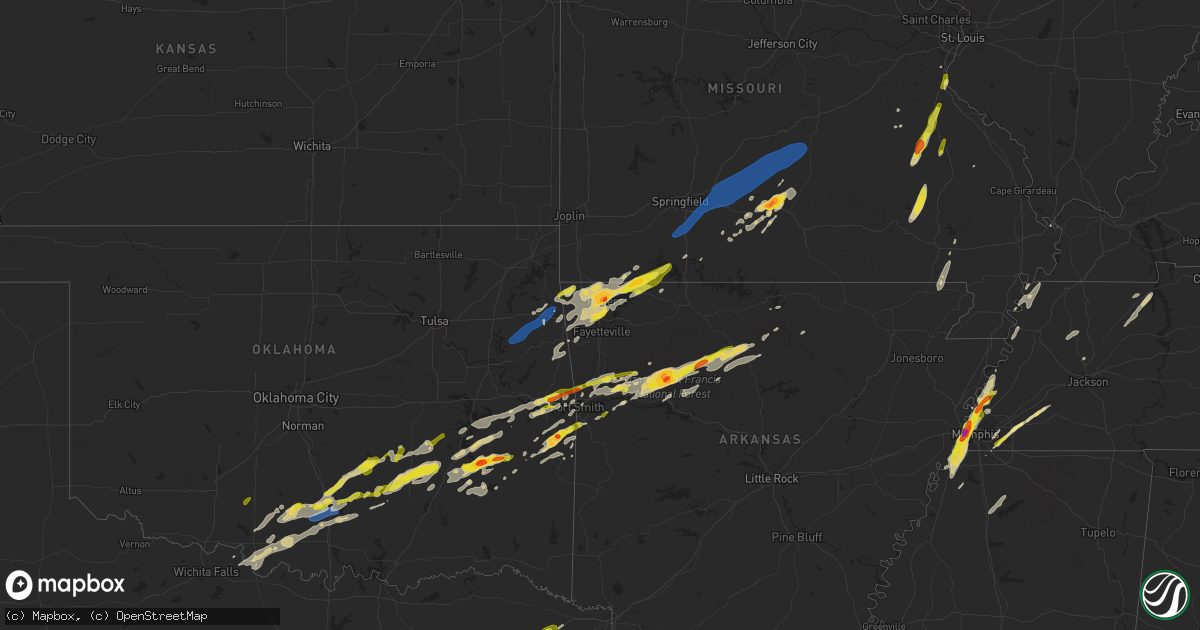
Hail Map on February 15, 2023
Get this storm
February 15 map
$229
one time, instant access
Download today. No call, no setup
Keep the $229
Bought the map and want the full workflow? Apply the entire $229 to a subscription within 7 days. None of it is wasted.
Every map, not just this one
This buys you this map. Subscription and you get every map we run, in the markets you choose from a few cities to whole states to nationwide. Plus real-time alerts the moment a storm fires.
Contact data
Name, contact info, occupancy, even credit band for addresses in the footprint. You go from where it hit to who to call.
Become the source they trust
Unlimited branding weather history reports on demand. You already have the documented answer ready for the property owner, and you are the one who showed up with it.
Property data and RoofTrace estimates
Pull up any address you have got, its value and the exact code rules for that jurisdiction, straight from One Click Code. Then RoofTrace estimates the squares, pitch, and roof value, priced the way you price.
States Impacted by Hail Map on February 15, 2023
Storm reports
Missouri
| Date | Description |
|---|---|
| 02/15/20233:10 AM CST | A local report indicates 1.25 inch wind near FESTUS |
| 02/15/20233:10 AM CST | Report from mping: quarter |
| 02/15/20233:08 AM CST | Hailed for approximately 2 minutes. Variety of hail sizes with largest stones to 1.25 inches. |
| 02/15/20232:49 AM CST | County dispatch received a report of a tree down on highway n. Time estimated from radar. |
| 02/15/20232:35 AM CST | County dispatch received a report of three trees down along long spring road in steelville. Time estimated from radar. |
| 02/15/20232:35 AM CST | Report from mping: quarter |
| 02/15/20232:32 AM CST | Via photo on facebook with hail also covering large portion of ground. |
| 02/15/20232:27 AM CST | County dispatch received a report of a tree down along highway m. Time estimated from radar. |
| 02/15/20232:24 AM CST | Report from mping: quarter |
| 02/15/20232:03 AM CST | Measured wind speed of 58 mph resulted in the breaking of 1 to 2 inch diameter tree branches 7 miles to the south of newburg. Time estimated from radar. |
| 02/15/20231:29 AM CST | A local report indicates 2.00 inch wind near MOUNTAIN GROVE |
| 02/15/20231:28 AM CST | Pictures showing hail of nickel to quarter size in mountain grove near old highway 60. Time estimated from radar. |
| 02/15/202312:59 AM CST | 7 miles east of niangua pea size hail and limbs down |
| 02/15/202312:27 AM CST | 59.6mph measured wind gust at 1227am cdt |
| 02/15/202312:12 AM CST | Mills rd s of country thyme a downed cedar tree in highlandville. |
| 02/15/202312:12 AM CST | Reports of small limbs down and power out. Estimated 60 plus mph. |
| 02/14/202311:49 PM CST | A local report indicates 1.00 inch wind near KIMBERLING CITY |
| 02/14/202311:45 PM CST | A local report indicates 1.00 inch wind near 5 ESE GOLDEN |
| 02/14/202311:41 PM CST | Near stone/barry line off yy. |
| 02/14/202311:37 PM CST | Report from mping: quarter |
| 02/14/202311:32 PM CST | Report from mping: quarter |
| 02/14/202311:28 PM CST | . |
Tennessee
| Date | Description |
|---|---|
| 02/15/20234:38 AM CST | Multiple trees down across old dyersburg rd and on a house |
| 02/14/202310:29 PM CST | Twitter report image. |
| 02/14/20239:43 PM CST | Report from mping. |
| 02/14/20239:25 PM CST | Corrects previous hail report from 7 w millington. Social media report. |
Arkansas
| Date | Description |
|---|---|
| 02/15/20233:15 AM CST | A local report indicates 62 MPH wind near CONWAY REGIONAL AIRPORT |
| 02/15/20232:10 AM CST | Damage to homes in the area as well as downed powerlines. Possible tornado. |
| 02/15/20232:01 AM CST | Debris was noted along with downed trees near fallsville. Possible tornado. |
| 02/15/20232:00 AM CST | Intital reports of trees and power lines downed. Several homes sustained roof damage. Possible tornado. |
| 02/15/20231:16 AM CST | A local report indicates 1.75 inch wind near OZONE |
| 02/15/202312:37 AM CST | Relayed by em. |
| 02/14/202311:51 PM CST | A local report indicates 60 MPH wind near VAN BUREN |
| 02/14/202311:35 PM CST | Report from mping: quarter |
| 02/14/202311:32 PM CST | Report from mping: half dollar |
| 02/14/202311:30 PM CST | Via sw mo media...time estimated by radar. |
| 02/14/202311:29 PM CST | A local report indicates 1.00 inch wind near 1 N SPRINGDALE |
| 02/14/202311:25 PM CST | Time estimated by radar. |
| 02/14/202311:24 PM CST | Report from mping: quarter |
| 02/14/202311:15 PM CST | Nickels to quarters reported. |
| 02/14/202311:14 PM CST | Report from mping: quarter |
| 02/14/202311:02 PM CST | Report and photo |
| 02/14/202310:31 PM CST | Broken windshield from fallen hail on twitter. Estimated 1.25in. |
| 02/14/202310:27 PM CST | A local report indicates 1.00 inch wind near 2 SE MAYSVILLE |
| 02/14/20239:10 PM CST | Corrects previous hail report from 2 ene west memphis. Broken windshield from fallen hail reported on social media. |
| 02/14/20239:10 PM CST | Hail report on twitter from @tristenwright3 slightly larger than a quarter. |
| 02/14/20239:07 PM CST | Hen egg sized hail reported on twitter. |
Oklahoma
| Date | Description |
|---|---|
| 02/15/202312:39 AM CST | A local report indicates 1.00 inch wind near CAMERON |
| 02/15/202312:37 AM CST | A local report indicates 1.00 inch wind near 1 WSW SCULLYVILLE |
| 02/15/202312:33 AM CST | A local report indicates 1.75 inch wind near 2 W POTEAU |
| 02/14/202311:38 PM CST | Hail reported 8 miles west of wilburton by tribal pd. |
| 02/14/202310:35 PM CST | Redbud housing in oaks lost a roof... Many trees down... Power outages reported. |
| 02/14/202310:15 PM CST | Delaware county emergency management reports widespread wind damage between colcord and kansas... Including roofs off buildings. |
| 02/14/202310:00 PM CST | Relayed by broadcast media. |
| 02/14/20239:54 PM CST | A local report indicates 69 MPH wind near HULBERT |
| 02/14/20238:43 PM CST | Quarter-sized hail reported in byng. |
| 02/14/20238:37 PM CST | Quarter-sized hail reported on northwest side of ada. |
Kentucky
| Date | Description |
|---|---|
| 02/15/202312:25 AM CST | A picture from the county emergency manager shows some quarter size hail mixed in with smaller hail on a deck. Time estimated from radar and it fits the em general sugg |
Cities Impacted by Hail Map on February 15, 2023
- Duncan, OK
- Davis, OK
- Stratford, OK
- Wynnewood, OK
- Hennepin, OK
- Sulphur, OK
- Ada, OK
- Sasakwa, OK
- Konawa, OK
- Ratliff City, OK
- Tussy, OK
- Elmore City, OK
- Allen, OK
- Holdenville, OK
- Atwood, OK
- Fitzhugh, OK
- Stonewall, OK
- Centrahoma, OK
- Tupelo, OK
- Mcalester, OK
- Coalgate, OK
- Calvin, OK
- Stuart, OK
- Roff, OK
- Indianola, OK
- Van Buren, AR
- Gans, OK
- Sallisaw, OK
- Uniontown, AR
- Muldrow, OK
- Wilburton, OK
- Red Oak, OK
- Hartshorne, OK
- Haileyville, OK
- Fort Smith, AR
- Pocola, OK
- Cameron, OK
- Hackett, AR
- Shady Point, OK
- Poteau, OK
- Springer, OK
- Kansas, OK
- Rose, OK
- Hulbert, OK
- Tahlequah, OK
- Oaks, OK
- Colcord, OK
- De Kalb, TX
- Sulphur Springs, AR
- Jay, OK
- Gravette, AR
- Maysville, AR
- Lowell, AR
- Springdale, AR
- Rogers, AR
- Kimberling City, MO
- Reeds Spring, MO
- Golden, MO
- Lampe, MO
- Eagle Rock, MO
- Eureka Springs, AR
- Shell Knob, MO
- Garfield, AR
- Cassville, MO
- Berryville, AR
- Mulberry, AR
- Mountainburg, AR
- Ozark, AR
- Charleston, AR
- Lavaca, AR
- Patterson, MO
- Piedmont, MO
- Mill Spring, MO
- Des Arc, MO
- Mountain Grove, MO
- Farmington, MO
- Fredericktown, MO
- Park Hills, MO
- Bismarck, MO
- Belleview, MO
- Bonne Terre, MO
- Ironton, MO
- Middle Brook, MO
- De Soto, MO
- Pilot Knob, MO
- Valles Mines, MO
- Herculaneum, MO
- Pevely, MO
- Festus, MO
- Crystal City, MO
- Proctor, AR
- Hughes, AR
- Marion, AR
- Memphis, TN
- Millington, TN
- Drummonds, TN
- Burlison, TN
- Lake Cormorant, MS
- Brighton, TN
- West Memphis, AR
- Tompkinsville, KY
- Gamaliel, KY
- Lafayette, TN
- Red Boiling Springs, TN
- Plato, MO
- Ozark, MO
- Sparta, MO
- Fort Leonard Wood, MO
- Newburg, MO
- Nixa, MO
- Licking, MO
- Ponce De Leon, MO
- Niangua, MO
- Galena, MO
- Lebanon, MO
- Beulah, MO
- Seymour, MO
- Grovespring, MO
- Edgar Springs, MO
- Fordland, MO
- Roby, MO
- Waynesville, MO
- Mansfield, MO
- Laquey, MO
- Falcon, MO
- Rogersville, MO
- Hartville, MO
- Highlandville, MO
- Duke, MO
- Lynchburg, MO
- Marshfield, MO
- Potosi, MO
- Ava, MO
- Melbourne, AR
- Taneyville, MO
- Broseley, MO
- Poplar Bluff, MO
- Kissee Mills, MO
- Forsyth, MO
- Green Forest, AR
- Walnut Shade, MO
- Branson, MO
- Roland, OK
- Drury, MO
- Vanzant, MO
- Belgrade, MO
- Patton, MO
- Puryear, TN
- Paris, TN
- Calico Rock, AR
- Lincoln, AR
- Imperial, MO
- Arcadia, MO
- Heavener, OK
- Howe, OK
- Wister, OK
- Keota, OK
- Bucyrus, MO
- Houston, MO
- Cabool, MO
- Norwood, MO
- Tiptonville, TN
- Corning, AR
- Pollard, AR
- Neelyville, MO
- Union City, TN
- Ridgely, TN
- Fisk, MO
- Macomb, MO
- Olive Branch, MS
- Humboldt, TN
- Summers, AR
- Eads, TN
- Oakland, TN
- Talihina, OK
- Arkoma, OK
- Canadian, OK
- Clayton, OK
- Talco, TX
- Lamar, AR
- Clarksville, AR
- Simms, TX
- Annapolis, MO
- Ellsinore, MO
- Watts, OK
- Huggins, MO
- Southaven, MS
- Petrolia, TX
- Big Flat, AR
- Greenwood, AR
- Hiwasse, AR
- Bentonville, AR
- Centerton, AR
- Leslie, AR
- Springville, TN
- Hollow Rock, TN
- Mansfield, TN
- McKenzie, TN
- Porum, OK
- Eufaula, OK
- Stigler, OK
- Vian, OK
- Quinton, OK
- Dyer, TN
- Trenton, TN
- Hector, AR
- Lamar, OK
- Wardville, OK
- Witts Springs, AR
- Marshall, AR
- Dover, AR
- Pittsburg, OK
- Tuskahoma, OK
- Bokoshe, OK
- Germantown, TN
- Cordova, TN
- Chester, AR
- Rudy, AR
- Cedarville, AR
- Alma, AR
- Dennard, AR
- Tilly, AR
- Ringling, OK
- Waurika, OK
- Ryan, OK
- Tishomingo, OK
- Blanco, OK
- Como, MS
- Ozone, AR
- Oark, AR
- Gentry, AR
- Siloam Springs, AR
- Spiro, OK
- Robinsonville, MS
- Walls, MS
- Hagarville, AR
- Westville, OK
- Stilwell, OK
- Mount Judea, AR
- Cookville, TX
- Collierville, TN
- Cecil, AR
- Kinta, OK
- Mill Creek, OK
- Pea Ridge, AR
- Bella Vista, AR
- Cave Springs, AR
- Fayetteville, AR
- Decatur, AR
- Seligman, MO
- Comanche, OK
- Wilson, OK
- Somerville, TN
- Henning, TN
- Kiowa, OK
- Hartman, AR
- Altus, AR
- Deer, AR
- Healdton, OK
- Pettigrew, AR
- Coldwater, MS
- Ardmore, OK
- Senatobia, MS
- Sardis, MS
- Finley, TN
- Pelsor, AR
- Dyer, AR
- Osceola, AR
- Tunica, MS
- Graham, OK
- Loco, OK
- Henrietta, TX
- Krebs, OK
- Terral, OK
- Lone Grove, OK
- Saint Joe, AR