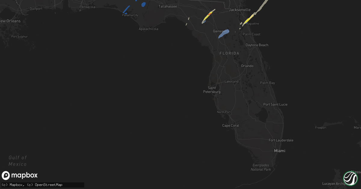
Hail Map in Florida on February 15, 2021
Get this storm
February 15 map
$229
one time, instant access
Download today. No call, no setup
Keep the $229
Bought the map and want the full workflow? Apply the entire $229 to a subscription within 7 days. None of it is wasted.
Every map, not just this one
This buys you this map. Subscription and you get every map we run, in the markets you choose from a few cities to whole states to nationwide. Plus real-time alerts the moment a storm fires.
Contact data
Name, contact info, occupancy, even credit band for addresses in the footprint. You go from where it hit to who to call.
Become the source they trust
Unlimited branding weather history reports on demand. You already have the documented answer ready for the property owner, and you are the one who showed up with it.
Property data and RoofTrace estimates
Pull up any address you have got, its value and the exact code rules for that jurisdiction, straight from One Click Code. Then RoofTrace estimates the squares, pitch, and roof value, priced the way you price.
Storm reports in Florida
Florida
| Date | Description |
|---|---|
| 02/15/20215:42 PM CST | Trees and power lines down at boston highway and still rd. |
| 02/15/20214:42 PM CST | Corrects time of previous tstm wnd dmg report from 3 ese alma. Trees and power lines down at boston highway and still rd. |
| 02/15/20213:41 PM CST | Deputy em in st. Johns county reported large hail about 1 inch in diameter just north of st. Augustine airport. Timing estimated based on radar data. |
| 02/15/20213:30 PM CST | Quarter and dime sized hail reported near wynwood ranch. |
| 02/15/20213:15 PM CST | Public sent photo via social media of golf ball sized hail in lake city... Fl. Estimated timing based on radar ata. |
| 02/15/20213:12 PM CST | Possible tornado damage. Roof damage to a couple structures and fencing blown through the window of a house. Timing estimated from radar. |
| 02/15/20213:12 PM CST | Possible tornado damage. Barn leveled on pinemount rd. Timing estimated based on radar. |
| 02/15/20213:10 PM CST | Public sent drone video of possible tornado damage via social media. Damage include fencing panel moved approximately 750 ft from original location and minor structural |
| 02/15/20213:10 PM CST | Wind damage was reported to at least |
| 02/15/20213:10 PM CST | Jackson county em advises that a mobile home sustained roof damage on green acres lane in alford. No displacements or injuries were reported. |
| 02/15/20213:09 PM CST | A local report indicates 58 MPH wind near MARIANNA MUNICIPAL A/P |
| 02/15/20213:00 PM CST | Trees down on highway 73 in northern calhoun county near the jackson county line. |
| 02/15/20213:00 PM CST | Tree down across all lanes of highway 71. |
| 02/15/20212:57 PM CST | Tree down on a trailer along nw county road 274. |
| 02/15/20212:41 PM CST | Photo of a snapped tree and other debris scattered in the area associated with a brief tds on radar. |
| 02/15/20212:30 PM CST | Report of some damage to a farm with a car port destroyed. Also some damage to nearby homes. |
| 02/15/20212:30 PM CST | Powerlines down on the west end of panama city beach. |
| 02/15/20212:30 PM CST | Three outages related to tree debris on power lines in the taylor and madison county areas. |
| 02/15/20212:25 PM CST | Carport destroyed by strong winds in southport. Report via social media. |
| 02/15/20212:21 PM CST | Social media report of a tree down on spikes road. |
| 02/15/20212:20 PM CST | Social media report of windows blown out and a small greenhouse destroyed near deane bozeman school. |
| 02/15/20212:20 PM CST | Trees across the roadway near highway 388 and burnt mill creek road. |
| 02/15/20212:05 PM CST | Social media report of multiple trees down in palmetto trace. |
| 02/15/20212:03 PM CST | Photo of power lines down near runway island in the panama city beach area. |
| 02/15/20216:55 AM CST | At 1255 PM CST, severe thunderstorms were located along a line extending from 4 miles south of Baker to Mary Esther to 28 miles south of Destin, moving northeast at 50 mph. HAZARD...60 mph wind gusts and quarter size hail. SOURCE...Radar indicated. IMPACT...Hail damage to vehicles is expected. Expect wind damage to roofs, siding, and trees. Locations impacted include... Wright, Fort Walton Beach, Crestview, Niceville, Destin, Eglin AFB, Valparaiso, Mary Esther, Ocean City, Lake Lorraine, Baker, Shalimar, Laurel Hill and Cinco Bayou. |
| 02/15/20216:53 AM CST | At 1253 PM CST, severe thunderstorms were located along a line extending from near Baker to 15 miles south of Mary Esther, moving northeast at 80 mph. HAZARD...60 mph wind gusts and quarter size hail. SOURCE...Radar indicated. IMPACT...Hail damage to vehicles is expected. Expect wind damage to roofs, siding, and trees. Locations impacted include... Santa Rosa Beach, De Funiak Springs, Eglin Air Force Base, Union, Liberty, Freeport, Paxton, Pond Creek, Oakwood Hills, Cluster Springs, Gaskin, Portland, Alpine Heights, Villa Tasso, Darlington, Blue Mountain Beach, De Funiak Spring Airport, Seaside, Rock Hill and Glendale. |
| 02/15/20215:11 AM CST | At 1111 PM EST, a severe thunderstorm was located near Loop Road Ee Center, or 26 miles east of Chokoloskee, moving northeast at 20 mph. HAZARD...60 mph wind gusts. SOURCE...Radar indicated. IMPACT...Expect damage to roofs, siding, and trees. Locations impacted include... Dade-Collier Training Airport. |
| 02/15/20211:07 AM CST | At 707 PM EST, severe thunderstorms were located along a line extending from 7 miles southeast of Mayo to 6 miles west of Fowlers Bluff, moving northeast at 60 mph. HAZARD...60 mph wind gusts and quarter size hail. SOURCE...Radar indicated. IMPACT...Hail damage to vehicles is expected. Expect wind damage to roofs, siding, and trees. Locations impacted include... Mayo, Cross City, Suwannee, Horseshoe Beach, Shamrock, Cross City Airport, Shired Island, Old Town, Guaranto Springs, Alton, Hines, Hatch Bend, Eugene, Fletcher, Yellow Jacket, San Pedro Junction, Fletcher Springs and Fanning Springs. |
| 02/15/202112:40 AM CST | At 640 PM EST, severe thunderstorms were located along a line extending from near Steinhatchee to 27 miles southwest of Horseshoe Point, moving northeast at 60 mph. HAZARD...60 mph wind gusts and quarter size hail. SOURCE...Radar indicated. IMPACT...Hail damage to vehicles is expected. Expect wind damage to roofs, siding, and trees. Locations impacted include... Cross City, Steinhatchee, Horseshoe Point, Suwannee, Horseshoe Beach, Tennille, Shamrock, Clara, Cross City Airport, Shired Island, Old Town, Guaranto Springs, Jena, Hines, Jonesboro, Eugene, Fletcher, Yellow Jacket and Fanning Springs. |
| 02/15/202112:31 AM CST | At 630 PM EST, a severe thunderstorm was located over Avalon Park, moving northeast at 40 mph. HAZARD...60 mph wind gusts. SOURCE...Radar indicated. IMPACT...Expect damage to roofs, siding, and trees. Locations impacted include... Orlando, Titusville, Oviedo, New Smyrna Beach and Wedgefield. |
| 02/14/202111:59 PM CST | At 558 PM EST, a severe thunderstorm was located over Saint Cloud, moving northeast at 40 mph. HAZARD...60 mph wind gusts. SOURCE...Radar indicated. IMPACT...Expect damage to roofs, siding, and trees. Locations impacted include... Orlando, Kissimmee, Saint Cloud, Wedgefield and Orlando International Airport. |
| 02/14/202111:53 PM CST | At 553 PM EST, severe thunderstorms were located along a line extending from 8 miles west of Madison to 11 miles south of Perry, moving northeast at 55 mph. HAZARD...60 mph wind gusts and quarter size hail. SOURCE...Radar indicated. IMPACT...Hail damage to vehicles is expected. Expect wind damage to roofs, siding, and trees. Locations impacted include... Mayo, Madison, Perry, Lee, Pinland, Hamburg, Buckville, Pinetta, Dekle Beach, Foley, Hanson, Perry-Foley Airport, San Pedro Junction, Moseley Hall, Chancey, Boyd, Smith, Hopewell, Cherry Lake and Carbur. |
| 02/14/202111:11 PM CST | At 510 PM EST, severe thunderstorms were located along a line extending from 10 miles east of St. Marks to 37 miles west of Steinhatchee, moving northeast at 70 mph. HAZARD...60 mph wind gusts and quarter size hail. SOURCE...Radar indicated. IMPACT...Hail damage to vehicles is expected. Expect wind damage to roofs, siding, and trees. Locations impacted include... Monticello, Perry, Greenville, Alma, Jug Island, Drifton, Scanlon, Lovett, Foley, Perry-Foley Airport, Hampton Springs, Lake Miccosukee, Iddo, Moseley Hall, Festus, Secotan, Boyd, Aucilla, Lois and Adams Beach. |
| 02/14/202110:44 PM CST | At 444 PM EST, a severe thunderstorm was located 12 miles north of Olustee, or 15 miles northeast of Lake City, moving northeast at 40 mph. HAZARD...60 mph wind gusts and quarter size hail. SOURCE...Radar indicated. IMPACT...Hail damage to vehicles is expected. Expect wind damage to roofs, siding, and trees. Locations impacted include... Taylor. |
| 02/14/202110:21 PM CST | At 421 PM EST, a severe thunderstorm was located over World Golf Village, or 9 miles southeast of Fruit Cove, moving northeast at 15 mph. HAZARD...60 mph wind gusts and quarter size hail. SOURCE...Radar indicated. IMPACT...Hail damage to vehicles is expected. Expect wind damage to roofs, siding, and trees. Locations impacted include... Ponte Vedra Beach, World Golf Village, Bostwick, Palm Valley, Sawgrass, Nocatee, South Ponte Vedra, Bayard, Durbin and Picolata. |
| 02/14/202110:01 PM CST | At 401 PM EST/301 PM CST/, severe thunderstorms were located along a line extending from 6 miles west of Fort Gaines to 7 miles east of Cottonwood, moving northeast at 75 mph. HAZARD...60 mph wind gusts and quarter size hail. SOURCE...Radar indicated. IMPACT...Hail damage to vehicles is expected. Expect wind damage to roofs, siding, and trees. Locations impacted include... Colquitt, Fort Gaines, Morgan, Blakely, Dawson, Cuthbert, Donalsonville, Edison, Arlington, Shellman, Columbia, Leary, Douglasville, Centerville, Gordon, Iron City, Damascus, Parrott, Jakin and Bellville. |
| 02/14/20219:41 PM CST | At 341 PM EST, a severe thunderstorm was located over Hollister, or 7 miles east of Interlachen, moving northeast at 15 mph. HAZARD...60 mph wind gusts and quarter size hail. SOURCE...Radar indicated. IMPACT...Hail damage to vehicles is expected. Expect wind damage to roofs, siding, and trees. Locations impacted include... Palatka, Interlachen, Hastings, East Palatka, World Golf Village, Picolata, Bostwick, Federal Point, Saint Augustine Shores and Orange Mills. |
| 02/14/20218:43 PM CST | At 243 PM EST, a severe thunderstorm was located 17 miles west of Steinhatchee, moving north at 55 mph. HAZARD...60 mph wind gusts and quarter size hail. SOURCE...Radar indicated. IMPACT...Hail damage to vehicles is expected. Expect wind damage to roofs, siding, and trees. Locations impacted include... Mayo, Perry, Steinhatchee, Greenville, Pinland, Jug Island, Ebb, Buckville, Dekle Beach, Jack Lee Island, Foley, Salem, Perry-Foley Airport, San Pedro Junction, Hampton Springs, Sirmans, Shady Grove, Cedar Island, Fish Creek and Cooks Hammock. |
| 02/14/20218:37 PM CST | At 237 PM CST, severe thunderstorms were located along a line extending from near Blue Springs State Park to 7 miles northeast of Chipley, moving northeast at 50 mph. HAZARD...60 mph wind gusts and quarter size hail. SOURCE...Radar indicated. IMPACT...Hail damage to vehicles is expected. Expect wind damage to roofs, siding, and trees. Locations impacted include... Abbeville, Cottonwood, Fort Gaines, Headland, Dothan, Ozark, Taylor, Midland City, Kinsey, Ashford, Slocomb, Cowarts, Newton, Webb, Columbia, Pinckard, Malvern, Rehobeth, Grimes and Avon. |
| 02/14/20218:08 PM CST | At 207 PM CST, severe thunderstorms were located along a line extending from 8 miles west of Ariton to near Geneva, moving northeast at 70 mph. HAZARD...60 mph wind gusts and quarter size hail. SOURCE...Radar indicated. IMPACT...Hail damage to vehicles is expected. Expect wind damage to roofs, siding, and trees. Locations impacted include... Geneva, Enterprise, Fort Rucker, New Brockton, Coffee Springs, Chancellor, Mixons Crossroads, Lytle, Lucile, Turner Crossroads, Lowry Mill, Central City, Geneva Municipal A/P, Clintonville, Roeton, Camp Alaflo Bsa, Clowers Crossroads, Arcus, Enterprise Municipal A/P and Woodland Grove Church. |
| 02/14/20217:57 PM CST | At 157 PM CST, severe thunderstorms were located along a line extending from 12 miles southwest of Brundidge to 11 miles northeast of De Funiak Springs, moving northeast at 80 mph. HAZARD...60 mph wind gusts and quarter size hail. SOURCE...Radar indicated. IMPACT...Hail damage to vehicles is expected. Expect wind damage to roofs, siding, and trees. Locations impacted include... Daleville, Headland, Dothan, Fort Rucker, Ozark, Enterprise, Hartford, Taylor, Midland City, Kinsey, Level Plains, Slocomb, Cowarts, Newton, Webb, Ariton, Pinckard, Malvern, Rehobeth and Clayhatchee. |
| 02/14/20217:36 PM CST | At 136 PM CST, severe thunderstorms were located along a line extending from 8 miles east of Florala to 20 miles southwest of Panama City Beach, moving east at 50 mph. HAZARD...60 mph wind gusts. SOURCE...Radar indicated. IMPACT...Expect damage to roofs, siding, and trees. Locations impacted include... Panama City, Lynn Haven, Panama City Beach, Callaway, Vernon, Bonifay, Chipley, Graceville, Springfield, Hiland Park, Tyndall Air Force Base, Bradford, Live Oak, Parker, Ponce De Leon, Caryville, Wausau, Esto, Westville and Ebro. |
| 02/14/20217:34 PM CST | At 134 PM CST, severe thunderstorms were located along a line extending from near Opp to 11 miles southeast of Florala, moving northeast at 80 mph. HAZARD...60 mph wind gusts and quarter size hail. SOURCE...Radar indicated. IMPACT...Hail damage to vehicles is expected. Expect wind damage to roofs, siding, and trees. Locations impacted include... Elba, Geneva, Enterprise, Fort Rucker, Samson, New Brockton, Lee, Kinston, Coffee Springs, Mixons Crossroads, Curtis, Carl Folsom A/p, Central City, Logan Field Municipal A/P, Camp Humming Hills, Clintonville, Roeton, Camp Alaflo Bsa, Arcus and Enterprise Municipal A/P. |
| 02/14/20216:15 PM CST | There were a few reports of trees blown down in dixie county. |
All States Impacted by Hail Map on February 15, 2021
Cities Impacted by Hail Map on February 15, 2021
- Soperton, GA
- Adrian, GA
- Wrightsville, GA
- Rockledge, GA
- Kite, GA
- Saint Augustine, FL
- Ponte Vedra Beach, FL
- Lake City, FL
- Wellborn, FL
- McAlpin, FL
- O'Brien, FL
- Interlachen, FL
- Ridgeland, SC
- Pineland, SC
- Tillman, SC
- Richmond Hill, GA
- Midway, GA
- Riceboro, GA
- Varnville, SC
- Branford, FL
- Savannah, GA
- Pooler, GA
- Port Wentworth, GA
- Cottonwood, AL
- Rincon, GA
- Townsend, GA
- Bloomingdale, GA
- Delco, NC
- Green Cove Springs, FL
- Palatka, FL
- Sparta, GA
- Perry, FL
- Burgaw, NC
- Slocomb, AL
- Hardeeville, SC
- Panama City, FL
- Chipley, FL
- Panama City Beach, FL
- Altha, FL
- Clarksville, FL
- Arlington, GA
- Colquitt, GA
- Damascus, GA
- Leary, GA
- Greenwood, FL
- Bascom, FL
- Alford, FL
- Marianna, FL
- Cottondale, FL
- Melrose, FL
- Earleton, FL
- Gainesville, FL
- Williston, FL
- Micanopy, FL
- Hawthorne, FL
- Bainbridge, GA
- Brinson, GA
- Newton, AL
- Hartford, AL
- Glenwood, GA
- Fort Stewart, GA
- Shallotte, NC
- Ash, NC
- Leland, NC
- Ocean Isle Beach, NC
- Sunset Beach, NC
- Riegelwood, NC
- Supply, NC
- Calabash, NC
- Currie, NC
- Rocky Point, NC


